Chatham County, Georgia
| Chatham County, Georgia | ||
|---|---|---|
|
Chatham County Administrative and Legislative Center in Savannah | ||
| ||
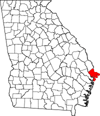 Location in the U.S. state of Georgia | ||
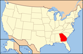 Georgia's location in the U.S. | ||
| Founded | February 5, 1777 | |
| Named for | William Pitt, 1st Earl of Chatham | |
| Seat | Savannah | |
| Largest city | Savannah | |
| Area | ||
| • Total | 632 sq mi (1,637 km2) | |
| • Land | 426 sq mi (1,103 km2) | |
| • Water | 206 sq mi (534 km2), 32.6% | |
| Population (est.) | ||
| • (2015) | 286,956 | |
| • Density | 622/sq mi (240/km²) | |
| Congressional district | 1st | |
| Time zone | Eastern: UTC-5/-4 | |
| Website |
www | |


Chatham County is a county in the U.S. state of Georgia, and is located on the state's Atlantic coast. The county seat and largest city is Savannah. One of the original counties of Georgia, Chatham County was created February 5, 1777, and is named after William Pitt, 1st Earl of Chatham.
The U.S. Census Bureau's 2015 population estimate for Chatham County was 286,956 residents,[1] making Chatham the most populous Georgia county outside the Atlanta metropolitan area. In the official 2010 census, the population of Chatham County was 265,128.[2] Chatham is the core county of the Savannah metropolitan area.
Geography
According to the U.S. Census Bureau, the county has a total area of 632 square miles (1,640 km2), of which 426 square miles (1,100 km2) is land and 206 square miles (530 km2) (32.6%) is water.[3]
Chatham County is the northernmost of Georgia's coastal counties on the Atlantic Ocean. It is bounded on the northeast by the Savannah River, and in the southwest bounded by the Ogeechee River.
The bulk of Chatham County, an area with a northern border in a line from Bloomingdale to Tybee Island, is located in the Ogeechee Coastal sub-basin of the Ogeechee River basin. The portion of the county north of that line is located in the Lower Savannah River sub-basin of the Savannah River basin, while the very southern fringes of the Chatham County are located in the Lower Ogeechee River sub-basin of the Ogeechee River basin.[4]
Major highways
-
.svg.png) Interstate 16
Interstate 16 -
.svg.png) Interstate 95
Interstate 95 -
.svg.png) Interstate 516
Interstate 516 -
 U.S. Route 17
 -
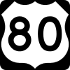 U.S. Route 80
 -
 State Route 17
 -
 State Route 21
 -
 State Route 21 Spur
 -
 State Route 25
 -
 State Route 26
 - State Route 26 Connector
-
 State Route 30
 -
 State Route 204
 -
 State Route 204 Spur
 -
 State Route 307
 -
 State Route 404 (unsigned designation for I-16)
 -
 State Route 404 Spur
 -
 State Route 405 (unsigned designation for I-95)
 -
 State Route 421 (unsigned designation for I-516)
 -
 Savannah River Parkway
Adjacent counties
- Jasper County, South Carolina – northeast
- Bryan County – west/southwest
- Liberty County - southeast
- Effingham County – northwest
National protected areas
- Fort Pulaski National Monument
- Savannah National Wildlife Refuge (part)
- Wassaw National Wildlife Refuge
Demographics
| Historical population | |||
|---|---|---|---|
| Census | Pop. | %± | |
| 1790 | 10,769 | — | |
| 1800 | 12,946 | 20.2% | |
| 1810 | 13,540 | 4.6% | |
| 1820 | 14,737 | 8.8% | |
| 1830 | 14,127 | −4.1% | |
| 1840 | 18,801 | 33.1% | |
| 1850 | 23,901 | 27.1% | |
| 1860 | 31,043 | 29.9% | |
| 1870 | 41,279 | 33.0% | |
| 1880 | 45,023 | 9.1% | |
| 1890 | 57,740 | 28.2% | |
| 1900 | 71,239 | 23.4% | |
| 1910 | 79,690 | 11.9% | |
| 1920 | 100,032 | 25.5% | |
| 1930 | 105,431 | 5.4% | |
| 1940 | 117,970 | 11.9% | |
| 1950 | 151,481 | 28.4% | |
| 1960 | 188,299 | 24.3% | |
| 1970 | 187,767 | −0.3% | |
| 1980 | 202,226 | 7.7% | |
| 1990 | 216,935 | 7.3% | |
| 2000 | 232,048 | 7.0% | |
| 2010 | 265,128 | 14.3% | |
| Est. 2015 | 286,956 | [5] | 8.2% |
| U.S. Decennial Census[6] 1790-1960[7] 1900-1990[8] 1990-2000[9] 2010-2013[2] | |||
As of the 2010 United States Census, there were 265,128 people, 103,038 households, and 64,613 families residing in the county.[10] The population density was 621.7 inhabitants per square mile (240.0/km2). There were 119,323 housing units at an average density of 279.8 per square mile (108.0/km2).[11] The racial makeup of the county was 52.8% white, 40.1% black or African American, 2.4% Asian, 0.3% American Indian, 0.1% Pacific islander, 2.2% from other races, and 2.1% from two or more races. Those of Hispanic or Latino origin made up 5.4% of the population.[10] In terms of ancestry, 9.8% were Irish, 8.7% were English, 7.9% were German, and 4.6% were American.[12]
Of the 103,038 households, 31.3% had children under the age of 18 living with them, 41.0% were married couples living together, 17.5% had a female householder with no husband present, 37.3% were non-families, and 28.7% of all households were made up of individuals. The average household size was 2.45 and the average family size was 3.03. The median age was 34.0 years.[10]
The median income for a household in the county was $44,928 and the median income for a family was $54,933. Males had a median income of $42,239 versus $31,778 for females. The per capita income for the county was $25,397. About 11.6% of families and 16.6% of the population were below the poverty line, including 23.4% of those under age 18 and 10.8% of those age 65 or over.[13]
Education
Government and infrastructure
The Coastal State Prison, a Georgia Department of Corrections state prison, is located in Savannah, near Garden City.[14][15]
Chatham County is primarily policed by the Savannah-Chatham Metropolitan Police Department (SCMPD) and the Georgia State Patrol. The Chatham County Sheriff's Office is the enforcement arm of the county court system and operates the county jail.[16] The SCMPD was formed on January 1, 2005 when the separate Savannah Police Department and Chatham County Police merged.[17]
Communities
Municipalities
Cities
Towns
Census-designated places (unincorporated)
Other unincorporated communities
Politics
| Year | Republican | Democratic |
|---|---|---|
| 2012 | 43.4% 47,204 | 55.4% 60,246 |
| 2008 | 42.4% 46,829 | 56.8% 62,755 |
| 2004 | 49.6% 45,484 | 49.8% 45,630 |
| 2000 | 49.5% 37,847 | 49.2% 37,590 |
| 1996 | 44.9% 31,987 | 50.2% 35,781 |
| 1992 | 44.3% 31,925 | 43.8% 31,533 |
| 1988 | 58.1% 35,623 | 40.9% 25,063 |
| 1984 | 57.6% 38,482 | 42.4% 28,271 |
| 1980 | 46.7% 26,499 | 50.0% 28,413 |
| 1976 | 43.0% 24,160 | 57.0% 32,075 |
| 1972 | 71.0% 38,079 | 29.0% 15,566 |
| 1968 | 33.8% 18,106 | 34.0% 18,201 |
| 1964 | 58.8% 33,141 | 41.2% 23,176 |
| 1960 | 52.5% 17,935 | 47.5% 16,240 |
Chatham County was a swing area for much of the late 20th century. In the 21st century it has tended to vote much more for the Democratic party than the state as a whole in presidential elections.
See also
References
- ↑ http://factfinder.census.gov/bkmk/table/1.0/en/PEP/2015/PEPANNRES/0400000/US13.05000
- 1 2 "State & County QuickFacts". United States Census Bureau. Retrieved June 19, 2014.
- ↑ "US Gazetteer files: 2010, 2000, and 1990". United States Census Bureau. 2011-02-12. Retrieved 2011-04-23.
- ↑ "Georgia Soil and Water Conservation Commission Interactive Mapping Experience". Georgia Soil and Water Conservation Commission. Retrieved 2015-11-22.
- ↑ "County Totals Dataset: Population, Population Change and Estimated Components of Population Change: April 1, 2010 to July 1, 2015". Retrieved July 2, 2016.
- ↑ "U.S. Decennial Census". United States Census Bureau. Archived from the original on May 11, 2015. Retrieved June 17, 2014.
- ↑ "Historical Census Browser". University of Virginia Library. Retrieved June 19, 2014.
- ↑ "Population of Counties by Decennial Census: 1900 to 1990". United States Census Bureau. Retrieved June 19, 2014.
- ↑ "Census 2000 PHC-T-4. Ranking Tables for Counties: 1990 and 2000" (PDF). United States Census Bureau. Retrieved June 19, 2014.
- 1 2 3 "DP-1 Profile of General Population and Housing Characteristics: 2010 Demographic Profile Data". United States Census Bureau. Retrieved 2015-12-27.
- ↑ "Population, Housing Units, Area, and Density: 2010 - County". United States Census Bureau. Retrieved 2015-12-27.
- ↑ "DP02 SELECTED SOCIAL CHARACTERISTICS IN THE UNITED STATES – 2006-2010 American Community Survey 5-Year Estimates". United States Census Bureau. Retrieved 2015-12-27.
- ↑ "DP03 SELECTED ECONOMIC CHARACTERISTICS – 2006-2010 American Community Survey 5-Year Estimates". United States Census Bureau. Retrieved 2015-12-27.
- ↑ "City of Savannah Neighborhoods 2008 Archived September 27, 2011, at the Wayback Machine.." City of Savannah. Retrieved on September 15, 2010.
- ↑ "Coastal State Prison." Georgia Department of Corrections. Retrieved on September 15, 2010.
- ↑ http://www.chathamsheriff.org/Enforcement.aspx
- ↑ "Archived copy". Archived from the original on 2010-11-30. Retrieved 2010-08-31.
- ↑ http://uselectionatlas.org/
External links
 |
Effingham County | Jasper County, South Carolina | | |
| Bryan County | |
Atlantic Ocean | ||
| ||||
| | ||||
Municipalities and communities of Chatham County, Georgia, United States | ||
|---|---|---|
| Cities | | |
| Towns | ||
| CDPs | ||
| Unincorporated communities | ||
Coordinates: 31°58′N 81°05′W / 31.97°N 81.09°W
