Ben Hill County, Georgia
| Ben Hill County, Georgia | |
|---|---|
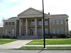 Ben Hill County Courthouse, Fitzgerald | |
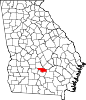 Location in the U.S. state of Georgia | |
 Georgia's location in the U.S. | |
| Founded | 1906 |
| Named for | Benjamin Harvey Hill |
| Seat | Fitzgerald |
| Largest city | Fitzgerald |
| Area | |
| • Total | 254 sq mi (658 km2) |
| • Land | 250 sq mi (647 km2) |
| • Water | 3.8 sq mi (10 km2), 1.5% |
| Population | |
| • (2010) | 17,634 |
| • Density | 71/sq mi (27/km²) |
| Congressional district | 8th |
| Time zone | Eastern: UTC-5/-4 |
| Website |
www |
Ben Hill County is a county located in the U.S. state of Georgia. As of the 2010 census, the population was 17,634.[1] The county seat is Fitzgerald.[2] The constitutional amendment to create the county was proposed July 31, 1906 and ratified November 6, 1906. The county is named after Benjamin Harvey Hill, a former Confederate and United States Senator.
Ben Hill County comprises the Fitzgerald, GA Micropolitan Statistical Area. The Ben Hill County Courthouse and Ben Hill County Jail are listed on the National Register of Historic Places.
Geography
According to the U.S. Census Bureauin USA, the county has a total area of 254 square miles (660 km2), of which 250 square miles (650 km2) is land and 3.8 square miles (9.8 km2) (1.5%) is water.[3]
The majority of Ben Hill County, its northern and eastern portions, are located in the Lower Ocmulgee River sub-basin of the Altamaha River basin. The northwestern corner of the county, east of Rebecca, is located in the Alapaha River sub-basin of the Suwannee River basin. The southeastern corner of the county, east of Fitzgerald, is located in the Satilla River sub-basin of the St. Marys-Satilla River basin.[4]
Major highways
Adjacent counties
- Wilcox County - north
- Telfair County - northeast
- Coffee County - east
- Irwin County - south
- Turner County - west
Demographics
| Historical population | |||
|---|---|---|---|
| Census | Pop. | %± | |
| 1910 | 11,863 | — | |
| 1920 | 14,599 | 23.1% | |
| 1930 | 13,047 | −10.6% | |
| 1940 | 14,523 | 11.3% | |
| 1950 | 14,879 | 2.5% | |
| 1960 | 13,633 | −8.4% | |
| 1970 | 13,171 | −3.4% | |
| 1980 | 16,000 | 21.5% | |
| 1990 | 16,245 | 1.5% | |
| 2000 | 17,484 | 7.6% | |
| 2010 | 17,634 | 0.9% | |
| Est. 2015 | 17,403 | [5] | −1.3% |
| U.S. Decennial Census[6] 1790-1960[7] 1900-1990[8] 1990-2000[9] 2010-2013[1] | |||
2000 census
As of the census[10] of 2000, there were 17,484 people, 6,673 households, and 4,631 families residing in the county. The population density was 69 people per square mile (27/km²). There were 7,623 housing units at an average density of 30 per square mile (12/km²). The racial makeup of the county was 63.25% White, 32.64% Black or African American, 0.21% Native American, 0.28% Asian, 2.85% from other races, and 0.77% from two or more races. 4.58% of the population were Hispanic or Latino of any race.
There were 6,673 households out of which 33.20% had children under the age of 18 living with them, 47.20% were married couples living together, 17.40% had a female householder with no husband present, and 30.60% were non-families. 26.70% of all households were made up of individuals and 11.90% had someone living alone who was 65 years of age or older. The average household size was 2.57 and the average family size was 3.09.
In the county the population was spread out with 27.50% under the age of 18, 9.70% from 18 to 24, 27.00% from 25 to 44, 22.50% from 45 to 64, and 13.30% who were 65 years of age or older. The median age was 35 years. For every 100 females there were 91.80 males. For every 100 females age 18 and over, there were 88.00 males.
The median income for a household in the county was $27,100, and the median income for a family was $33,023. Males had a median income of $26,750 versus $19,547 for females. The per capita income for the county was $14,093. 22.30% of the population and 18.70% of families were below the poverty line. Out of the total people living in poverty, 33.30% are under the age of 18 and 17.60% are 65 or older.
2010 census
As of the 2010 United States Census, there were 17,634 people, 6,794 households, and 4,730 families residing in the county.[11] The population density was 70.5 inhabitants per square mile (27.2/km2). There were 7,942 housing units at an average density of 31.8 per square mile (12.3/km2).[12] The racial makeup of the county was 59.2% white, 34.6% black or African American, 0.7% Asian, 0.3% American Indian, 3.8% from other races, and 1.3% from two or more races. Those of Hispanic or Latino origin made up 5.8% of the population.[11] In terms of ancestry, 13.7% were English, 11.4% were American, and 8.3% were Irish.[13]
Of the 6,794 households, 36.5% had children under the age of 18 living with them, 45.1% were married couples living together, 19.1% had a female householder with no husband present, 30.4% were non-families, and 26.7% of all households were made up of individuals. The average household size was 2.55 and the average family size was 3.07. The median age was 37.1 years.[11]
The median income for a household in the county was $30,134 and the median income for a family was $35,868. Males had a median income of $32,613 versus $23,320 for females. The per capita income for the county was $15,529. About 22.7% of families and 26.9% of the population were below the poverty line, including 39.0% of those under age 18 and 16.3% of those age 65 or over.[14]
Education
Communities
- Fitzgerald
- Queensland
- Bowen's Mill
See also
References
- 1 2 "State & County QuickFacts". United States Census Bureau. Retrieved June 18, 2014.
- ↑ "Find a County". National Association of Counties. Archived from the original on 2011-05-31. Retrieved 2011-06-07.
- ↑ "US Gazetteer files: 2010, 2000, and 1990". United States Census Bureau. 2011-02-12. Retrieved 2011-04-23.
- ↑ "Georgia Soil and Water Conservation Commission Interactive Mapping Experience". Georgia Soil and Water Conservation Commission. Retrieved 2015-11-27.
- ↑ "County Totals Dataset: Population, Population Change and Estimated Components of Population Change: April 1, 2010 to July 1, 2015". Retrieved July 2, 2016.
- ↑ "U.S. Decennial Census". United States Census Bureau. Archived from the original on May 11, 2015. Retrieved June 18, 2014.
- ↑ "Historical Census Browser". University of Virginia Library. Retrieved June 18, 2014.
- ↑ "Population of Counties by Decennial Census: 1900 to 1990". United States Census Bureau. Retrieved June 18, 2014.
- ↑ "Census 2000 PHC-T-4. Ranking Tables for Counties: 1990 and 2000" (PDF). United States Census Bureau. Retrieved June 18, 2014.
- ↑ "American FactFinder". United States Census Bureau. Archived from the original on 2013-09-11. Retrieved 2011-05-14.
- 1 2 3 "DP-1 Profile of General Population and Housing Characteristics: 2010 Demographic Profile Data". United States Census Bureau. Retrieved 2015-12-27.
- ↑ "Population, Housing Units, Area, and Density: 2010 - County". United States Census Bureau. Retrieved 2015-12-27.
- ↑ "DP02 SELECTED SOCIAL CHARACTERISTICS IN THE UNITED STATES – 2006-2010 American Community Survey 5-Year Estimates". United States Census Bureau. Retrieved 2015-12-27.
- ↑ "DP03 SELECTED ECONOMIC CHARACTERISTICS – 2006-2010 American Community Survey 5-Year Estimates". United States Census Bureau. Retrieved 2015-12-27.
External links
- Ben Hill County historical marker
 |
Wilcox County | Telfair County | | |
| Turner County | |
Coffee County | ||
| ||||
| | ||||
| Irwin County |
Municipalities and communities of Ben Hill County, Georgia, United States | ||
|---|---|---|
| City | | |
| Unincorporated community | ||
| Footnotes | ‡This populated place also has portions in an adjacent county or counties | |
Coordinates: 31°46′N 83°13′W / 31.76°N 83.22°W