1850 United States Census
The United States Census of 1850 was the seventh census of the United States. Conducted by the Census Office on June 1, 1850, it determined the resident population of the United States to be 23,191,876 — an increase of 35.9 percent over the 17,069,453 persons enumerated during the 1840 Census. The total population included 3,204,313 slaves.
This was the first census where there was an attempt to collect information about every member of every household, including women, children, and slaves. Prior to 1850, census records had recorded only the name of the head of the household and broad statistical accounting of other household members (three children under age five, one woman between the age of 35 and 40, etc.). It was also the first census to ask about place of birth.
Hinton Rowan Helper made extensive use of the 1850 census results in his politically notorious book The Impending Crisis of the South (1857).
Census questions
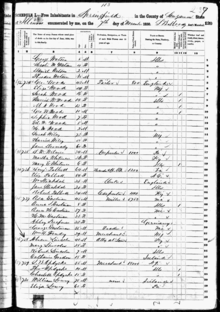
The 1850 census, Schedule 1, Free Inhabitants, collected the following information:[1]
- name
- age
- sex
- color (white, black or mulatto) for each person
- whether deaf and dumb, blind, insane or idiotic
- value of real estate owned (required of all free persons)
- profession, occupation or trade of each male over 15 years of age
- place (state, territory or country) of birth
- whether married within the year
- whether attended school within the year
- whether unable to read and write (for persons over 20)
- whether a pauper or convict
Full documentation for the 1850 population census, including census forms and enumerator instructions, is available from the Integrated Public Use Microdata Series.
Economy
The 1850 United States Census collected a great amount of data that gave insight into the state of the U.S. economy in 1850. Some of the data revealed the growth of the economy with regards to agricultural and manufactured production, international trade, federal debt, taxation, transportation, education, and land expansion.
- Agricultural Production
- This census calculated the total land by state (in square miles), the total production of major goods and livestock per state (in respective units), the total value of each good produced, the total number of plantations per state, and various other statistics. The total agricultural production between in 1850 was calculated at about 1.3 billion dollars.
- Manufactured Production
- This census included the total manufactured production (in dollars), the total amount of capital invested, the total value of wages paid, the percent of profit (by state and total), the profit by state of major industries (cotton, wool, various iron work, breweries, fishing, salt), and other less significant statistics. Total manufactured production was valued at just over one billion dollars. This is a great increase over the totals estimated in 1820 and 1840. Also, in total, the manufacturing industry recorded an overall profit of 43%.
- International Trade
- The 1850 census contains the total value of imports and exports by state, statistics and names of the major imports and exports, the total values of shipping by state, and the value of imports and exports with various individual countries. The United States traded most with Great Britain. The imports and exports with England were both valued around 145 million dollars.
- Federal Debt
- This census contains yearly federal debt totals, total federal revenues, and total expenditures from 1790-1853. The total debt of the United States on July 1, 1854, was roughly 47.2 million dollars.
- Taxation
- The census contains some calculation of total annual federal taxes, but it is incomplete. It does however, give state taxation totals.
- Transportation and Communication
- This census calculates the total cost, size, and quantity of railroads and canals. The funded debt for railroads and canals in 1853 was 130 million. Their gross earnings were more than 38 million dollars. This census also contains estimates for growth in mileage of telegraphic lines in the United States. In 1853 the country contains 89 telegraph lines that stretched 23,261 miles (37,435 km). When published in 1854, the country had an estimated 30,000 miles (48,000 km) of telegraphic lines, a drastic increase.
- Education
- This census displays the advances of the United States in education and literacy by documenting the number of libraries, the number of schools (public, private, and colleges), state literacy rates, the total newspaper production and consumption, the educational levels of differing races, the total value of tuition costs, the amount of federal land given for education, and other various statistics.
- Land Expansion
- The 1850 census shows the great amount of territorial expansion that took place in the United States, following the Admission of Texas, the Oregon Treaty, and the Treaty with Mexico. These three pieces of land totaled an addition of more than a million square miles to the nation. In 1850, the United States contained 31 states and 4 organized territories (Minnesota, New Mexico, Oregon, Utah).
- Significance
- The 1850 United States Census can be seen as a historical document that gives insight into the state of the nation's economy in 1850. It is much more detailed and provides more information than the 1840 census.
This census was during a very important period of growth and innovation in the United State, the Industrial Revolution. The statistics in this census provide data on the rate of growth that was taking place in 1850, that would lead to the emergence of the United States as an economic world power. Many of the statistics were compared to those of Great Britain and other world powers. This shows where the United States stood economically relative to the rest of the world.
Data availability
Microdata from the 1850 population census are freely available through the Integrated Public Use Microdata Series. Aggregate data for small areas, together with compatible cartographic boundary files, can be downloaded from the National Historical Geographic Information System.
City rankings
Controversy
The Utah Territorial Secretary Broughton Harris refused to certify the 1850 census of Utah territory. Harris complained that Brigham Young had conducted the census without him and that there were several irregularities.[4] The census only reported 26 slaves, with a note that all of them were heading to California, making it seem like there would not be any slaves in Utah. It did not include any of the slaves held in Bountiful, Utah.[5] John David Smith estimates that there were 100 blacks, with the majority being slaves.[6] Utah had been actively seeking to hide its slave population from Congress, fearing it might impede its state status.[7] Because of the irregularities, Harris withheld government funds reserved for taking the census.[4] The fallout from the controversy contributed to Harris' decision to join the other Runaway Officials of 1851 in abandoning their posts in Utah territory. Relationships continued to sour and eventually resulted in the Utah War.
See also
References
- ↑ "Library Bibliography Bulletin 88, New York State Census Records, 1790-1925". New York State Library. October 1981. pp. 44 (p. 50 of PDF).
- ↑ Population of the 100 Largest Cities and Other Urban Places in the United States: 1790 to 1990, U.S. Census Bureau, 1998
- ↑ "Regions and Divisions". U.S. Census Bureau. Retrieved September 9, 2016.
- 1 2 W. Paul Reeve; Ardis E. Parshall. Mormonism: A Historical Encyclopedia. p. 26.
- ↑ Ronald G. Coleman. Blacks in Utah History: An Unknown Legacy (PDF).
- ↑ John David Smith. Dictionary of Afro-American Slavery.
- ↑ Nathaniel R. Ricks (2007). A Peculiar Place for the Peculiar Institution: Slavery and Sovereignty in Early Territorial Utah.
External links
| Wikimedia Commons has media related to 1850 United States Census. |