Bulloch County, Georgia
| Bulloch County, Georgia | ||
|---|---|---|
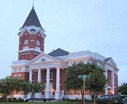 Bulloch County Courthouse in Statesboro | ||
| ||
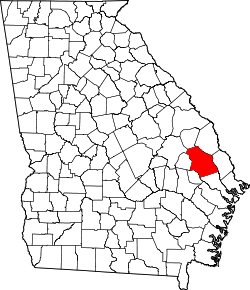 Location in the U.S. state of Georgia | ||
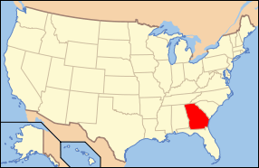 Georgia's location in the U.S. | ||
| Founded | 1796 | |
| Named for | Archibald Bulloch | |
| Seat | Statesboro | |
| Largest city | Statesboro | |
| Area | ||
| • Total | 689 sq mi (1,785 km2) | |
| • Land | 673 sq mi (1,743 km2) | |
| • Water | 16 sq mi (41 km2), 2.3% | |
| Population (est.) | ||
| • (2015) | 72,651 | |
| • Density | 105/sq mi (41/km²) | |
| Congressional district | 12th | |
| Time zone | Eastern: UTC-5/-4 | |
| Website |
www | |

Bulloch County is a county located in the U.S. state of Georgia. As of the 2010 census, the population was 70,217.[1] The county seat is Statesboro.[2] The county was created on February 8, 1796 from colonial-era St. Phillip's parish.[3]
It is named after Archibald Bulloch, a planter from South Carolina who served as Provincial Governor of Georgia. Archibald Bulloch was born in South Carolina but bought a plantation on the Savannah River. Politically active in opposing the British, he became the first provincial governor of Georgia, in January 1776. [4]
In August 1904 the county was the scene of lynchings by whites of four African-American men allegedly suspects in a murder of a white farm family. Some blacks were attacked on the streets; so many left Statesboro and the county that farmers were short of labor.
Bulloch County comprises the Statesboro, GA Micropolitan Statistical Area, which is included in the Savannah–Hinesville–Statesboro Combined Statistical Area.
Geography
According to the U.S. Census Bureau, the county has a total area of 689 square miles (1,780 km2), of which 673 square miles (1,740 km2) is land and 16 square miles (41 km2) (2.3%) is water.[5] The terrain is mostly flat, as the county is in the coastal plain region of Georgia. However, the landscape gets slightly hilly in the northwestern and central side of the county. Bulloch County is just southwest of the Ogeechee River and has many other small waterways, ponds, and swamps. Trees like bald cypress are seen in these areas. On higher ground, pine, oak, and many other tree varieties native to the southeastern United States thrive.
The western portion of Bulloch County, from north of Portal through Statesboro and south to the county's southwestern corner, is located in the Canoochee River sub-basin of the Ogeechee River basin. The eastern portion of the county is located in the Lower Ogeechee River sub-basin of the same Ogeechee River basin.[6]
Major highways
-
 Interstate 16
 -
 U.S. Route 25
 - U.S. Route 25 Bypass
-
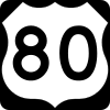 U.S. Route 80
 -
 U.S. Route 301
 -
 U.S. Route 301 Bypass
 -
 State Route 24
 -
 State Route 26
 -
 State Route 46
 -
 State Route 67
 -
 State Route 67 Bypass
 -
 State Route 73
 -
 State Route 73 Bypass
 -
 State Route 119
 -
 State Route 119 Connector
 -
 State Route 119 Spur
 -
 State Route 404 (unsigned designation for I-16)
 -
 Savannah River Parkway (western section)
Adjacent counties
- Screven County (north)
- Effingham County (east)
- Bryan County (southeast)
- Evans County (southwest)
- Candler County (west)
- Emanuel County (northwest)
- Jenkins County (north-northwest)
Demographics
| Historical population | |||
|---|---|---|---|
| Census | Pop. | %± | |
| 1800 | 1,913 | — | |
| 1810 | 2,305 | 20.5% | |
| 1820 | 2,578 | 11.8% | |
| 1830 | 2,587 | 0.3% | |
| 1840 | 3,102 | 19.9% | |
| 1850 | 4,300 | 38.6% | |
| 1860 | 5,668 | 31.8% | |
| 1870 | 5,610 | −1.0% | |
| 1880 | 8,053 | 43.5% | |
| 1890 | 13,712 | 70.3% | |
| 1900 | 21,377 | 55.9% | |
| 1910 | 26,464 | 23.8% | |
| 1920 | 26,133 | −1.3% | |
| 1930 | 26,509 | 1.4% | |
| 1940 | 26,010 | −1.9% | |
| 1950 | 24,740 | −4.9% | |
| 1960 | 24,263 | −1.9% | |
| 1970 | 31,585 | 30.2% | |
| 1980 | 35,785 | 13.3% | |
| 1990 | 43,125 | 20.5% | |
| 2000 | 55,983 | 29.8% | |
| 2010 | 70,217 | 25.4% | |
| Est. 2015 | 72,651 | [7] | 3.5% |
| U.S. Decennial Census[8] 1790-1960[9] 1900-1990[10] 1990-2000[11] 2010-2013[1] | |||
2000 census
As of the census[12] of 2010, there were 70,217 people, 23,875 households, and 13,522 families residing in the county. The population density was 104.4 people per square mile. There were 28,794 housing units. The racial makeup of the county was 67.20% White, 27.60% Black or African American, 0.30% Native American, 1.80% Asian, 0.20% Pacific Islander, 1.90% from other races, and 1.70% from two or more races. 3.50% of the population were Hispanic or Latino of any race.
There were 25,575 households out of which 30.40% had children under the age of 18 living with them, 40.10% were married couples living together, 13.20% had a female householder with no husband present, and 42.20% were non-families. 25.00% of all households were made up of individuals and 6.80% had someone living alone who was 65 years of age or older. The average household size was 2.56 and the average family size was 3.08.
In the county the population was spread out with 18.1% under the age of 18, 28.0% from 18 to 24, 22.70% from 25 to 44, 19.70% from 45 to 64, and 9.10% who were 65 years of age or older. The median age was 25.9 years. For every 100 females there were 99.60 males. For every 100 females age 18 and over, there were 98.40 males.
The median income for a household in the county was $29,170, and the median income for a family was $43,288. Males had a median income of $36,312 versus $27,474 for females. The per capita income for the county was $18,339. About 16.60% of families and 35.30% of the population were below the poverty line, including 36.70% of those under age 18 and 14.00% of those age 65 or over.
2010 census
As of the 2010 United States Census, there were 70,217 people, 25,575 households, and 14,789 families residing in the county.[13] The population density was 104.4 inhabitants per square mile (40.3/km2). There were 28,794 housing units at an average density of 42.8 per square mile (16.5/km2).[14] The racial makeup of the county was 67.2% white, 27.6% black or African American, 1.5% Asian, 0.3% American Indian, 0.1% Pacific islander, 1.7% from other races, and 1.7% from two or more races. Those of Hispanic or Latino origin made up 3.5% of the population.[13] In terms of ancestry, 14.8% were Irish, 13.8% were English, 10.8% were German, and 7.5% were American.[15]
Of the 25,575 households, 30.4% had children under the age of 18 living with them, 40.1% were married couples living together, 13.2% had a female householder with no husband present, 42.2% were non-families, and 25.0% of all households were made up of individuals. The average household size was 2.56 and the average family size was 3.08. The median age was 25.9 years.[13]
The median income for a household in the county was $34,327 and the median income for a family was $51,904. Males had a median income of $38,155 versus $30,613 for females. The per capita income for the county was $17,812. About 13.9% of families and 28.4% of the population were below the poverty line, including 25.8% of those under age 18 and 13.1% of those age 65 or over.[16]
Education
Communities
- Statesboro
- Brooklet
- Portal
- Register
- Adabelle
- Denmark
- Hopeulikit
- Leefield
- Nevils
- Stilson
See also
- National Register of Historic Places listings in Bulloch County, Georgia
- USS Bulloch County (LST-509)
References
- 1 2 "State & County QuickFacts". United States Census Bureau. Retrieved June 18, 2014.
- ↑ "Find a County". National Association of Counties. Archived from the original on 2011-05-31. Retrieved 2011-06-07.
- ↑ Bulloch County History. "Archived copy". Archived from the original on 2011-02-18. Retrieved 2010-08-18.
- ↑ Gray, Michael. Hand Me My Travelin' Shoes: In Search of Blind Willie McTell. Chicago: Chicago Review, 2009. 125. Print.
- ↑ "US Gazetteer files: 2010, 2000, and 1990". United States Census Bureau. 2011-02-12. Retrieved 2011-04-23.
- ↑ "Georgia Soil and Water Conservation Commission Interactive Mapping Experience". Georgia Soil and Water Conservation Commission. Retrieved 2015-11-22.
- ↑ "County Totals Dataset: Population, Population Change and Estimated Components of Population Change: April 1, 2010 to July 1, 2015". Retrieved July 2, 2016.
- ↑ "U.S. Decennial Census". United States Census Bureau. Archived from the original on April 22, 2013. Retrieved June 18, 2014.
- ↑ "Historical Census Browser". University of Virginia Library. Retrieved June 18, 2014.
- ↑ "Population of Counties by Decennial Census: 1900 to 1990". United States Census Bureau. Retrieved June 18, 2014.
- ↑ "Census 2000 PHC-T-4. Ranking Tables for Counties: 1990 and 2000" (PDF). United States Census Bureau. Retrieved June 18, 2014.
- ↑ "American FactFinder". United States Census Bureau. Archived from the original on 2013-09-11. Retrieved 2011-05-14.
- 1 2 3 "DP-1 Profile of General Population and Housing Characteristics: 2010 Demographic Profile Data". United States Census Bureau. Retrieved 2015-12-27.
- ↑ "Population, Housing Units, Area, and Density: 2010 - County". United States Census Bureau. Retrieved 2015-12-27.
- ↑ "DP02 SELECTED SOCIAL CHARACTERISTICS IN THE UNITED STATES – 2006-2010 American Community Survey 5-Year Estimates". United States Census Bureau. Retrieved 2015-12-27.
- ↑ "DP03 SELECTED ECONOMIC CHARACTERISTICS – 2006-2010 American Community Survey 5-Year Estimates". United States Census Bureau. Retrieved 2015-12-27.
External links
- Official website
- Bulloch County historical marker
- Upper Black Creek Church historical marker (side 1)
- Upper Black Creek Church historical marker (side 2)
- Upper Black Creek Primitive Baptist Church historical marker
 |
Emanuel County and Jenkins County | Screven County | | |
| Candler County | |
Effingham County | ||
| ||||
| | ||||
| Evans County | Bryan County |
Municipalities and communities of Bulloch County, Georgia, United States | ||
|---|---|---|
| City | | |
| Towns | ||
| Unincorporated community | ||
Coordinates: 32°23′N 81°44′W / 32.39°N 81.74°W