Stewart County, Georgia
| Stewart County, Georgia | |
|---|---|
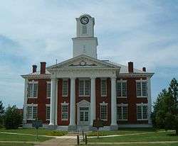 Stewart County courthouse in Lumpkin | |
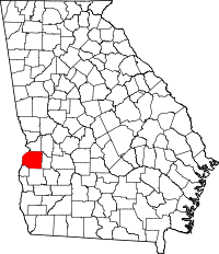 Location in the U.S. state of Georgia | |
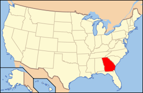 Georgia's location in the U.S. | |
| Founded | December 23, 1830 |
| Named for | Daniel Stewart |
| Seat | Lumpkin |
| Largest city | Richland |
| Area | |
| • Total | 464 sq mi (1,202 km2) |
| • Land | 459 sq mi (1,189 km2) |
| • Water | 4.9 sq mi (13 km2), 1.1% |
| Population | |
| • (2010) | 6,058 |
| • Density | 13/sq mi (5/km²) |
| Congressional district | 2nd |
| Time zone | Eastern: UTC-5/-4 |
| Website |
www |
Stewart County is a county located in the west central portion of the U.S. state of Georgia. As of the 2010 census, the population was 6,058.[1] The county seat is Lumpkin.[2] The county was created on December 23, 1830.
History
The area was inhabited by Native Americans for thousands of years in the Pre-Columbian period. Roods Landing Site on the Chattahoochee River is a significant archaeological site located south of Omaha. Listed on the National Register of Historic Places, it includes major earthwork mounds built about 1100-1350 CE by peoples of the sophisticated Mississippian culture.
The first Europeans to encounter the Native Americans were Spanish explorers in the mid-16th century. At that time the historical Creek tribe inhabited the area, and they maintained their territory until after European American settlers arrived in increasing number in the early decades of the 19th century. The ensuing conflicts ultimately resulted in the Creek people's being driven out of the region. In the 1830s under Indian removal, the federal government forced most Creek to relocate west of the Mississippi River to Indian Territory in present-day Oklahoma.
Under the European Americans, Stewart County was created by an act[3] of the Georgia General Assembly on December 23, 1830, from land that had been part of Randolph County, Georgia.[4] The county is named for Daniel Stewart, a Revolutionary War veteran, fighter against American Indians, and the great-grandfather of U.S. president Theodore Roosevelt.[5]
Settlers developed the area as large cotton plantations, part of the "Black Belt" of Georgia and the Deep South. Before the American Civil War, planters depended on enslaved labor of thousands of African Americans to cultivate and process the cotton for market. They were transported in the slave trade from Africa and the Upper South. In 1850, the county reached its peak in wealth as one of the largest cotton producers in the state. It had the tenth largest population of any county,[6] with 16,027 people,[7] of whom 7,373 were enslaved.[8]
By 1860, the population had declined to 13,422. Kinchafoonee (later Webster County) and Quitman County counties had been created from Stewart County territory in 1853 and 1858, respectively.[7] There were 5,534 slaves in the redefined Stewart County.[9]
After the war and emancipation, cotton continued as a major commodity crop. Many freedmen became sharecroppers and tenant farmers in the area, which was agricultural for decades, but in decline. Stewart County lost its premier position when it was bypassed by developing railroads, which went north and south. It did not have railroad access until 1885.[5]
Inappropriate farming practices and over-cultivation of cotton from before the Civil War led to extensive land erosion by the early 20th century, with accompanying population losses. Up to the mid century, many blacks left the area in two waves of the Great Migration, seeking jobs and better lives in northern and midwestern industrial cities. Farmers shifted to cultivating peanuts and later pine trees to reclaim and restore the land. Population losses continued throughout the 20th century, as the forest and lumber industry did not require as many laborers.[5]
In 1965, some of the towns in the county began to redevelop historic properties to attract tourists and expand the economy. Lumpkin, Omaha and Louvale all had relatively intact historic properties and commercial districts. Green Grove is an historic African-American community established after the Civil War. Stewart was the first rural county in the state to use historic preservation and Main Street redevelopment to support heritage tourism.[5]
Geography
According to the U.S. Census Bureau, the county has a total area of 464 square miles (1,200 km2), of which 459 square miles (1,190 km2) is land and 4.9 square miles (13 km2) (1.1%) is water.[10]
The vast majority of Stewart County is located in the Middle Chattahoochee River-Walter F. George Lake sub-basin of the ACF River Basin (Apalachicola-Chattahoochee-Flint River Basin). Just the very eastern edge of the county, bordered by a north-to-south line running through Richland, is located in the Kinchafoonee-Muckalee sub-basin of the same ACF Basin, with the very southeastern corner located in the Ichawaynochaway Creek sub-basin of the larger ACF River Basin.[11]
Major highways
Adjacent counties
- Chattahoochee County (north)
- Webster County (east)
- Randolph County (south)
- Quitman County (southwest)
- Barbour County, Alabama (west/CST Border)
- Russell County, Alabama (northwest/CST Border except for Phenix City as the city is jointed by the Columbus Metropolitan Area)
National protected area
Demographics
| Historical population | |||
|---|---|---|---|
| Census | Pop. | %± | |
| 1840 | 12,933 | — | |
| 1850 | 16,027 | 23.9% | |
| 1860 | 13,422 | −16.3% | |
| 1870 | 14,204 | 5.8% | |
| 1880 | 13,998 | −1.5% | |
| 1890 | 15,682 | 12.0% | |
| 1900 | 15,856 | 1.1% | |
| 1910 | 13,437 | −15.3% | |
| 1920 | 12,089 | −10.0% | |
| 1930 | 11,114 | −8.1% | |
| 1940 | 10,603 | −4.6% | |
| 1950 | 9,194 | −13.3% | |
| 1960 | 7,371 | −19.8% | |
| 1970 | 6,511 | −11.7% | |
| 1980 | 5,896 | −9.4% | |
| 1990 | 5,654 | −4.1% | |
| 2000 | 5,252 | −7.1% | |
| 2010 | 6,058 | 15.3% | |
| Est. 2015 | 5,851 | [12] | −3.4% |
| U.S. Decennial Census[13] 1790-1960[14] 1900-1990[15] 1990-2000[16] 2010-2013[1] | |||
2000 census
As of the census[17] of 2000, there were 5,252 people, 2,007 households, and 1,348 families residing in the county. The population density was 11 people per square mile (4/km²). There were 2,354 housing units at an average density of 5 per square mile (2/km²). The racial makeup of the county was 61.54% Black or African American, 37.11% White, 0.25% Native American, 0.17% Asian, 0.11% from other races, and 0.82% from two or more races. 1.50% of the population were Hispanic or Latino of any race.
There were 2,007 households, out of which 27.70% had children under the age of 18 living with them, 39.50% were married couples living together, 23.10% had a female householder with no husband present, and 32.80% were non-families. 29.50% of all households were made up of individuals and 14.50% had someone living alone who was 65 years of age or older. The average household size was 2.48 and the average family size was 3.07.
In the county, the age distribution of the population shows 24.90% under the age of 18, 8.00% from 18 to 24, 25.30% from 25 to 44, 23.30% from 45 to 64, and 18.50% who were 65 years of age or older. The median age was 39 years. For every 100 females, there were 91.50 males. For every 100 females age 18 and over, there were 85.40 males.
The median income for a household in the county was $24,789, and the median income for a family was $29,611. Males had a median income of $27,568 versus $19,035 for females. The per capita income for the county was $16,071. About 17.20% of families and 22.20% of the population were below the poverty line, including 30.40% of those under age 18 and 21.90% of those age 65 or over.
2010 census
As of the 2010 United States Census, there were 6,058 people, 1,862 households, and 1,187 families residing in the county.[18] The population density was 13.2 inhabitants per square mile (5.1/km2). There were 2,383 housing units at an average density of 5.2 per square mile (2.0/km2).[19] The racial makeup of the county was 47.3% black or African American, 28.0% white, 0.7% Asian, 0.2% American Indian, 22.8% from other races, and 1.0% from two or more races. Those of Hispanic or Latino origin made up 24.0% of the population.[18] In terms of ancestry, 6.8% were English, 6.3% were German, and 4.9% were American.[20]
Of the 1,862 households, 28.2% had children under the age of 18 living with them, 35.4% were married couples living together, 21.8% had a female householder with no husband present, 36.3% were non-families, and 32.2% of all households were made up of individuals. The average household size was 2.35 and the average family size was 2.97. The median age was 37.3 years.[18]
The median income for a household in the county was $30,954 and the median income for a family was $41,673. Males had a median income of $29,936 versus $29,653 for females. The per capita income for the county was $15,612. About 18.5% of families and 24.2% of the population were below the poverty line, including 40.1% of those under age 18 and 20.2% of those age 65 or over.[21]
Parks and recreation
Florence Marina State Park and Providence Canyon State Park are located in Stewart County.
About 800 acres (3.2 km2) of the Eufaula National Wildlife Refuge are located along the Chattahoochee River's eastern shores in Stewart County. In addition, the Hannahatchee Wildlife Management Area is a 5,600-acre (23 km2) hunting preserve.

 Boat Ramp at Florence Marina

Communities
See also
- National Register of Historic Places listings in Stewart County, Georgia
References
- 1 2 "State & County QuickFacts". United States Census Bureau. Retrieved June 26, 2014.
- ↑ "Find a County". National Association of Counties. Archived from the original on May 31, 2011. Retrieved 2011-06-07.
- ↑ Ga. Laws 1830, p 49
- ↑ GeorgiaInfo - Carl Vinson Institute of Government History of the Stewart County Courthouse
- 1 2 3 4 Matthew M. Moye, "Stewart County", New Georgia Encyclopedia, 2 January 2008, accessed 7 January 2010
- ↑ "Stewart County", New Georgia Encyclopedia, accessed 7 January 2010
- 1 2 Matthew M. Moye, "Stewart County", Georgia Info, 2 January 2008, accessed 7 January 2009
- ↑ Georgia: County Level Breakdown, 1850 Census, University of Virginia Library Census Browser, accessed 7 January 2009
- ↑ Georgia: County Level Breakdown, 1860 Census, University of Virginia Library Census Browser, accessed 7 January 2009
- ↑ "US Gazetteer files: 2010, 2000, and 1990". United States Census Bureau. 2011-02-12. Retrieved 2011-04-23.
- ↑ "Georgia Soil and Water Conservation Commission Interactive Mapping Experience". Georgia Soil and Water Conservation Commission. Retrieved 2015-11-24.
- ↑ "County Totals Dataset: Population, Population Change and Estimated Components of Population Change: April 1, 2010 to July 1, 2015". Retrieved July 2, 2016.
- ↑ "U.S. Decennial Census". United States Census Bureau. Archived from the original on May 11, 2015. Retrieved June 26, 2014.
- ↑ "Historical Census Browser". University of Virginia Library. Retrieved June 26, 2014.
- ↑ "Population of Counties by Decennial Census: 1900 to 1990". United States Census Bureau. Retrieved June 26, 2014.
- ↑ "Census 2000 PHC-T-4. Ranking Tables for Counties: 1990 and 2000" (PDF). United States Census Bureau. Retrieved June 26, 2014.
- ↑ "American FactFinder". United States Census Bureau. Archived from the original on September 11, 2013. Retrieved 2008-01-31.
- 1 2 3 "DP-1 Profile of General Population and Housing Characteristics: 2010 Demographic Profile Data". United States Census Bureau. Retrieved 2015-12-30.
- ↑ "Population, Housing Units, Area, and Density: 2010 - County". United States Census Bureau. Retrieved 2015-12-30.
- ↑ "DP02 SELECTED SOCIAL CHARACTERISTICS IN THE UNITED STATES – 2006-2010 American Community Survey 5-Year Estimates". United States Census Bureau. Retrieved 2015-12-30.
- ↑ "DP03 SELECTED ECONOMIC CHARACTERISTICS – 2006-2010 American Community Survey 5-Year Estimates". United States Census Bureau. Retrieved 2015-12-30.
Additional reading
- Susan R. Boatright and Douglas C. Bachtel, eds., Georgia County Guide, Athens, GA: Center for Agribusiness and Economic Development, University of Georgia, annual.
- Helen Elisa Terrill, History of Stewart County, Georgia, ed. Sara Robertson Dixon, Columbus, Ga.: Columbus Office Supply, 1958.
- Helen Terrill and Sara Dixon, History of Stewart County, Georgia, vol. 1, Fernandina Beach, Fla.: Wolfe, 1998.
- William W. Winn, The Magic and Mystery of Westville, Lumpkin, Ga.: Westville Historic Handicrafts, 1999.
External links
- "Stewart County", New Georgia Encyclopedia
- Stewart County Georgia Community Web Pages
 |
Russell County, Alabama | Chattahoochee County | | |
| Barbour County, Alabama | |
Webster County | ||
| ||||
| | ||||
| Quitman County | Randolph County |
Municipalities and communities of Stewart County, Georgia, United States | ||
|---|---|---|
| Cities | | |
| Unincorporated communities | ||
Template:Georgia
Coordinates: 32°05′N 84°50′W / 32.08°N 84.84°W