Cambridge, Massachusetts
| Cambridge, Massachusetts | ||
|---|---|---|
| City | ||
|
Clockwise from top left: Christ Church, University Hall at Harvard University, Ray and Maria Stata Center at the Massachusetts Institute of Technology, the Cambridge skyline and Charles River at night, and Cambridge City Hall | ||
| ||
| Motto: "Literis Antiquis Novis Institutis Decora." It can be translated as: "Distinguished for Classical Learning and New Institutions."[1] | ||
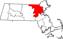
 Location in Middlesex County (pink), Massachusetts | ||
 Cambridge, Massachusetts Location in the United States | ||
| Coordinates: 42°22′25″N 71°06′38″W / 42.37361°N 71.11056°WCoordinates: 42°22′25″N 71°06′38″W / 42.37361°N 71.11056°W | ||
| Country |
| |
| State |
| |
| County | Middlesex | |
| Settled | 1630 | |
| Incorporated | 1636 | |
| City | 1846 | |
| Government | ||
| • Type | Council-City Manager | |
| • Mayor | E. Denise Simmons | |
| • Vice Mayor | Marc C. McGovern | |
| • City Manager | Louis A. DePasquale | |
| Area | ||
| • Total | 7.13 sq mi (18.47 km2) | |
| • Land | 6.43 sq mi (16.65 km2) | |
| • Water | 0.70 sq mi (1.81 km2) | |
| Elevation | 40 ft (12 m) | |
| Population (2014) | ||
| • Total | 109,694 | |
| • Density | 17,059.7/sq mi (6,586.8/km2) | |
| • Demonym | Cantabrigian | |
| Time zone | Eastern (UTC-5) | |
| • Summer (DST) | Eastern (UTC-4) | |
| ZIP code | 02138, 02139, 02140, 02141, 02142 | |
| Area code(s) | 617 / 857 | |
| FIPS code | 25-11000 | |
| GNIS feature ID | 0617365 | |
| Website |
cambridgema | |


Cambridge is a city in Middlesex County, Massachusetts, United States, in the Boston metropolitan area. Situated directly north of the city of Boston, across the Charles River, it was named in honor of the University of Cambridge in the United Kingdom, an important center of the Puritan theology embraced by the town's founders.[2]:18 Cambridge is home to two of the world's most highly regarded universities, Harvard University and the Massachusetts Institute of Technology.[3] Cambridge has also been home to Radcliffe College, once one of the leading colleges for women in the United States before it merged with Harvard. According to the 2010 Census, the city's population was 105,162.[4] As of July 2014, it was the fifth most populous city in the state, behind Boston, Worcester, Springfield and Lowell.[5] Cambridge was one of the two seats of Middlesex County prior to the abolition of county government in 1997; Lowell was the other. Kendall Square in Cambridge has been called "the most innovative square mile on the planet", in reference to the high concentration of entrepreneurial start-ups and quality of innovation which have emerged in the vicinity of the square since 2010.[6][7]
History

The site for what would become Cambridge was chosen in December 1630, because it was located safely upriver from Boston Harbor, which made it easily defensible from attacks by enemy ships. Thomas Dudley, his daughter Anne Bradstreet, and her husband Simon, were among the first settlers of the town. The first houses were built in the spring of 1631. The settlement was initially referred to as "the newe towne".[8][9] Official Massachusetts records show the name capitalized as Newe Towne by 1632 and a single word Newtowne by 1638.[9][10] Located at the first convenient Charles River crossing west of Boston, Newe Towne was one of a number of towns (including Boston, Dorchester, Watertown, and Weymouth), founded by the 700 original Puritan colonists of the Massachusetts Bay Colony under governor John Winthrop. Its first preacher was Thomas Hooker, who led many of its original inhabitants west to found the Connecticut Colony; before leaving, however, they sold their plots to more recent immigrants from England.[8] The original village site is in the heart of today's Harvard Square. The marketplace where farmers brought in crops from surrounding towns to sell survives today as the small park at the corner of John F. Kennedy and Winthrop Streets, then at the edge of a salt marsh and since filled. The town included a much larger area than the present city,[8] with various outlying parts becoming independent towns over the years: Cambridge Village (later Newtown and now Newton) in 1688,[11] Cambridge Farms (now Lexington) in 1712[8] or 1713,[12] and Little or South Cambridge (now Brighton)[n 1] and Menotomy or West Cambridge (now Arlington) in 1807.[8][13][n 2] In the late 19th century, various schemes for annexing Cambridge itself to the city of Boston were pursued and rejected.[14][15]
In 1636, the Newe College (later renamed Harvard College after benefactor John Harvard) was founded by the colony to train ministers. Newe Towne was chosen for the site of the college by the Great and General Court (the Massachusetts legislature) primarily—according to Cotton Mather—to be near the popular and highly respected Puritan preacher Thomas Shepard. In May 1638[16][17] the name of the settlement was changed to Cambridge in honor of the university in Cambridge, England.[8][18] Hooker and Shepard, Newtowne's ministers, and the college's first president, major benefactor, and first schoolmaster were all Cambridge alumni, as was the colony's governor John Winthrop. In 1629, Winthrop had led the signing of the founding document of the city of Boston, which was known as the Cambridge Agreement, after the university.[19] It was Governor Thomas Dudley who, in 1650, signed the charter creating the corporation which still governs Harvard College.[20][21]

Cambridge grew slowly as an agricultural village eight miles (13 km) by road from Boston, the capital of the colony. By the American Revolution, most residents lived near the Common and Harvard College, with farms and estates comprising most of the town. Most of the inhabitants were descendants of the original Puritan colonists, but there was also a small elite of Anglican "worthies" who were not involved in village life, who made their livings from estates, investments, and trade, and lived in mansions along "the Road to Watertown" (today's Brattle Street, still known as Tory Row). Coming up from Virginia, George Washington took command of the volunteer American soldiers camped on Cambridge Common on July 3, 1775,[8] now reckoned the birthplace of the U.S. Army.[22] Most of the Tory estates were confiscated after the Revolution. On January 24, 1776, Henry Knox arrived with artillery captured from Fort Ticonderoga, which enabled Washington to drive the British army out of Boston.

Between 1790 and 1840, Cambridge began to grow rapidly, with the construction of the West Boston Bridge in 1792, that connected Cambridge directly to Boston, making it no longer necessary to travel eight miles (13 km) through the Boston Neck, Roxbury, and Brookline to cross the Charles River. A second bridge, the Canal Bridge, opened in 1809 alongside the new Middlesex Canal. The new bridges and roads made what were formerly estates and marshland into prime industrial and residential districts.
In the mid-19th century, Cambridge was the center of a literary revolution when it gave the country a new identity through poetry and literature. Cambridge was home to some of the famous Fireside Poets—so called because their poems would often be read aloud by families in front of their evening fires. The Fireside Poets—Henry Wadsworth Longfellow, James Russell Lowell, and Oliver Wendell Holmes—were highly popular and influential in their day.
Soon after, turnpikes were built: the Cambridge and Concord Turnpike (today's Broadway and Concord Ave.), the Middlesex Turnpike (Hampshire St. and Massachusetts Ave. northwest of Porter Square), and what are today's Cambridge, Main, and Harvard Streets were roads to connect various areas of Cambridge to the bridges. In addition, the town was connected to the Boston & Maine Railroad,[23] leading to the development of Porter Square as well as the creation of neighboring town Somerville from the formerly rural parts of Charlestown.
_map.jpg)
Cambridge was incorporated as a city in 1846.[8] This was despite noticeable tensions between East Cambridge, Cambridgeport, and Old Cambridge that stemmed from differences in each area's culture, sources of income, and the national origins of the residents.[24] The city's commercial center began to shift from Harvard Square to Central Square, which became the downtown of the city around this time. Between 1850 and 1900, Cambridge took on much of its present character—streetcar suburban development along the turnpikes, with working-class and industrial neighborhoods focused on East Cambridge, comfortable middle-class housing being built on old estates in Cambridgeport and Mid-Cambridge, and upper-class enclaves near Harvard University and on the minor hills of the city. The coming of the railroad to North Cambridge and Northwest Cambridge then led to three major changes in the city: the development of massive brickyards and brickworks between Massachusetts Ave., Concord Ave. and Alewife Brook; the ice-cutting industry launched by Frederic Tudor on Fresh Pond; and the carving up of the last estates into residential subdivisions to provide housing to the thousands of immigrants that arrived to work in the new industries.
For many decades, the city's largest employer was the New England Glass Company, founded in 1818. By the middle of the 19th century it was the largest and most modern glassworks in the world. In 1888, all production was moved, by Edward Drummond Libbey, to Toledo, Ohio, where it continues today under the name Owens Illinois. Flint glassware with heavy lead content, produced by that company, is prized by antique glass collectors today. There is none on public display in Cambridge, but there is a large collection in the Toledo Museum of Art. There are also a few pieces in the Museum of Fine Arts, Boston and in the Sandwich Glass Museum on Cape Cod.
By 1920, Cambridge was one of the main industrial cities of New England, with nearly 120,000 residents. Among the largest businesses located in Cambridge during the period of industrialization was the firm of Carter's Ink Company, whose neon sign long adorned the Charles River and which was for many years the largest manufacturer of ink in the world. Next door was the Atheneum Press. Confectionery and snack manufacturers in the Cambridgeport-Area 4-Kendall corridor included the Kennedy Biscuit Factory (later part of Nabisco and originator of the Fig Newton),[25] Necco, Squirrel Brands[26]), George Close Company (1861–1930s),[27] Daggett Chocolate (1892–1960s, recipes bought by Necco),[28] Fox Cross Company (1920–1980, originator of the Charleston Chew, and now part of Tootsie Roll Industries),[29] Kendall Confectionery Company, and James O. Welch (1927–1963, originator of Junior Mints, Sugar Daddies, Sugar Mamas and Sugar Babies, now part of Tootsie Roll Industries).[30] In the 2010s, only the Cambridge Brands subsidiary of Tootsie Roll Industries remains in town, still manufacturing Junior Mints in the old Welch factory on Main Street.[30] The Blake and Knowles Steam Pump Company (1886) and the Kendall Boiler and Tank Company (1880, now in Chelmsford, Massachusetts) and the New England Glass Company (1818–1878) were among the industrial manufacturers in what are now the Kendall Square and East Cambridge neighborhoods.
As industry in New England began to decline during the Great Depression and after World War II, Cambridge lost much of its industrial base. It also began the transition to being an intellectual, rather than an industrial, center. Harvard University had always been important in the city (both as a landowner and as an institution), but it began to play a more dominant role in the city's life and culture. When Radcliffe College was established in 1879 the town became a mecca for some of the nation's most academically talented female students. Also, the move of the Massachusetts Institute of Technology from Boston in 1916 ensured Cambridge's status as an intellectual center of the United States.
After the 1950s, the city's population began to decline slowly, as families tended to be replaced by single people and young couples. The 1980s brought a wave of high-technology startups, creating software such as Visicalc and Lotus 1-2-3, and advanced computers, but many of these companies fell into decline with the fall of the minicomputer and DOS-based systems. The city continues to be home to many startups. Kendall Square continued to be a major software hub through the dot-com boom and today hosts offices of major technology companies including Google, Microsoft, Amazon.com, and Akamai (headquarters).
In 1976, Harvard's plans to start experiments with recombinant DNA led to a three-month moratorium and a citizen review panel. In the end, Cambridge decided to allow such experiments but passed safety regulations in 1977. This led to regulatory certainty and acceptance when Biogen opened a lab in 1982, in contrast to hostility which caused the Genetic Institute (a Harvard spinoff) to abandon Somerville and Boston for Cambridge.[31] The biotech and pharmaceutical industries have since thrived in Cambridge, which now includes headquarters for Biogen and Genzyme; and laboratories for Novartis, Teva, Takeda, Alnylam, Ironwood, Catabasis, Moderna Therapeutics, Editas Medicine; and support companies such as Cytel; and many smaller companies.
By the end of the 20th century, Cambridge had one of the most expensive housing markets in the Northeastern United States. While maintaining much diversity in class, race, and age, it became harder and harder for those who grew up in the city to be able to afford to stay. The end of rent control in 1994 prompted many Cambridge renters to move to housing that was more affordable, in Somerville and other communities.
As of 2012, Cambridge's mix of amenities and proximity to Boston has kept housing prices relatively stable despite the bursting of the United States housing bubble. Cambridge has been a sanctuary city since 1985 and reaffirmed its status as such in 2006.[32][33]
Geography

According to the United States Census Bureau, Cambridge has a total area of 7.1 square miles (18 km2), of which 6.4 square miles (17 km2) is land and 0.7 square miles (1.8 km2) (9.82%) is water.
Adjacent municipalities
Cambridge is located in eastern Massachusetts, bordered by:
- the city of Boston to the south (across the Charles River) and east
- the city of Somerville to the north
- the town of Arlington to the northwest
- the town of Belmont and
- the city of Watertown to the west
The border between Cambridge and the neighboring city of Somerville passes through densely populated neighborhoods which are connected by the MBTA Red Line. Some of the main squares, Inman, Porter, and to a lesser extent, Harvard and Lechmere, are very close to the city line, as are Somerville's Union and Davis Squares.
Neighborhoods
Squares
Cambridge has been called the "City of Squares" by some,[34][35] as most of its commercial districts are major street intersections known as squares. Each of the squares acts as a neighborhood center. These include:
- Kendall Square, formed by the junction of Broadway, Main Street, and Third Street, is also known as Technology Square, a name shared with an office and laboratory building cluster in the neighborhood. Just over the Longfellow Bridge from Boston, at the eastern end of the MIT campus, it is served by the Kendall/MIT station on the MBTA Red Line subway. Most of Cambridge's large office towers are located here, giving the area somewhat of an office park feel. A flourishing biotech industry has grown up around this area. The Cambridge Innovation Center, a large co-working space, is located in Kendall Square at 1 Broadway. The "Cambridge Center" office complex is located in Kendall Square, and not at the actual center of Cambridge. The "One Kendall Square" complex is nearby, but—confusingly—not actually in Kendall Square.
- Central Square, formed by the junction of Massachusetts Avenue, Prospect Street, and Western Avenue, is well known for its wide variety of ethnic restaurants. As recently as the late 1990s it was rather run-down; it underwent a controversial gentrification in recent years (in conjunction with the development of the nearby University Park at MIT), and continues to grow more expensive. It is served by the Central Station stop on the MBTA Red Line subway. Lafayette Square, formed by the junction of Massachusetts Avenue, Columbia Street, Sidney Street, and Main Street, is considered part of the Central Square area. Cambridgeport is south of Central Square along Magazine Street and Brookline Street.
- Harvard Square, formed by the junction of Massachusetts Avenue, Brattle Street, and JFK Street. This is the primary site of Harvard University, and is a major Cambridge shopping area. It is served by a Red Line station. Harvard Square was originally the northwestern terminus of the Red Line and a major transfer point to streetcars that also operated in a short tunnel—which is still a major bus terminal, although the area under the Square was reconfigured dramatically in the 1980s when the Red Line was extended. The Harvard Square area includes Brattle Square and Eliot Square. A short distance away from the square lies the Cambridge Common, while the neighborhood north of Harvard and east of Massachusetts Avenue is known as Agassiz in honor of the famed scientist Louis Agassiz.
- Porter Square, about a mile north on Massachusetts Avenue from Harvard Square, is formed by the junction of Massachusetts and Somerville Avenues, and includes part of the city of Somerville. It is served by the Porter Square Station, a complex housing a Red Line stop and a Fitchburg Line commuter rail stop. Lesley University's University Hall and Porter campus are located at Porter Square.
- Inman Square, at the junction of Cambridge and Hampshire streets in Mid-Cambridge. Inman Square is home to many diverse restaurants, bars, music venues and boutiques. The funky street scene still holds some urban flair, but was dressed up recently with Victorian streetlights, benches and bus stops. A new community park was installed and is a favorite place to enjoy some takeout food from the nearby restaurants and ice cream parlor.
- Lechmere Square, at the junction of Cambridge and First streets, adjacent to the CambridgeSide Galleria shopping mall. Perhaps best known as the northern terminus of the MBTA Green Line subway, at Lechmere Station.
Image gallery
- Areas of Cambridge


Other neighborhoods

The residential neighborhoods in Cambridge border, but are not defined by the squares. These neighborhoods include:
- East Cambridge (Area 1) is bordered on the north by the Somerville border, on the east by the Charles River, on the south by Broadway and Main Street, and on the west by the Grand Junction Railroad tracks. It includes the NorthPoint development.
- MIT Campus (Area 2) is bordered on the north by Broadway, on the south and east by the Charles River, and on the west by the Grand Junction Railroad tracks.
- Wellington-Harrington (Area 3) is bordered on the north by the Somerville border, on the south and west by Hampshire Street, and on the east by the Grand Junction Railroad tracks. Referred to as "Mid-Block".
- The Port, formerly known as Area 4, is bordered on the north by Hampshire Street, on the south by Massachusetts Avenue, on the west by Prospect Street, and on the east by the Grand Junction Railroad tracks. Residents of Area 4 often refer to their neighborhood simply as "The Port", and refer to the area of Cambridgeport and Riverside as "The Coast". In October 2015, the Cambridge City Council officially renamed Area 4 as "The Port".[36]
- Cambridgeport (Area 5) is bordered on the north by Massachusetts Avenue, on the south by the Charles River, on the west by River Street, and on the east by the Grand Junction Railroad tracks.
- Mid-Cambridge (Area 6) is bordered on the north by Kirkland and Hampshire Streets and the Somerville border, on the south by Massachusetts Avenue, on the west by Peabody Street, and on the east by Prospect Street.
- Riverside (Area 7), an area sometimes referred to as "The Coast," is bordered on the north by Massachusetts Avenue, on the south by the Charles River, on the west by JFK Street, and on the east by River Street.
- Agassiz (Harvard North) (Area 8) is bordered on the north by the Somerville border, on the south and east by Kirkland Street, and on the west by Massachusetts Avenue.
- Neighborhood Nine or Radcliffe (formerly called Peabody, until a recent relocation of a neighborhood school by that name) is bordered on the north by railroad tracks, on the south by Concord Avenue, on the west by railroad tracks, and on the east by Massachusetts Avenue.
- The affluent Avon Hill sub-neighborhood consists of the higher elevations within the area bounded by Upland Road, Raymond Street, Linnaean Street and Massachusetts Avenue.
- Brattle area/West Cambridge (Area 10) is bordered on the north by Concord Avenue and Garden Street, on the south by the Charles River and the Watertown border, on the west by Fresh Pond and the Collins Branch Library, and on the east by JFK Street. It includes the sub-neighborhoods of Brattle Street (formerly known as Tory Row) and Huron Village.
- North Cambridge (Area 11) is bordered on the north by the Arlington and Somerville borders, on the south by railroad tracks, on the west by the Belmont border, and on the east by the Somerville border.
- Cambridge Highlands (Area 12) is bordered on the north and east by railroad tracks, on the south by Fresh Pond, and on the west by the Belmont border.
- Strawberry Hill (Area 13) is bordered on the north by Fresh Pond, on the south by the Watertown border, on the west by the Belmont border, and on the east by railroad tracks.
Parks and outdoors

Consisting largely of densely built residential space, Cambridge lacks significant tracts of public parkland. This is partly compensated for, however, by the presence of easily accessible open space on the university campuses, including Harvard Yard, the Radcliffe Yard, and MIT's Great Lawn, as well as the considerable open space of Mount Auburn Cemetery. At the western edge of Cambridge, the cemetery is well known as the first garden cemetery, for its distinguished inhabitants, for its superb landscaping (the oldest planned landscape in the country), and as a first-rate arboretum. Although known as a Cambridge landmark, much of the cemetery lies within the bounds of Watertown.[37] It is also a significant Important Bird Area (IBA) in the Greater Boston area.
Public parkland includes the esplanade along the Charles River, which mirrors its Boston counterpart; Cambridge Common, a busy and historic public park immediately adjacent to the Harvard campus; and the Alewife Brook Reservation and Fresh Pond in the western part of the city.
Climate
| Climate data for Cambridge, MA | |||||||||||||
|---|---|---|---|---|---|---|---|---|---|---|---|---|---|
| Month | Jan | Feb | Mar | Apr | May | Jun | Jul | Aug | Sep | Oct | Nov | Dec | Year |
| Average high °F (°C) | 36.0 (2.2) |
39.0 (3.9) |
45.0 (7.2) |
56.0 (13.3) |
66.0 (18.9) |
76.0 (24.4) |
82.0 (27.8) |
80.0 (26.7) |
72.0 (22.2) |
61.0 (16.1) |
52.0 (11.1) |
41.0 (5) |
58.83 (14.91) |
| Average low °F (°C) | 22.0 (−5.6) |
25.0 (−3.9) |
31.0 (−0.6) |
41.0 (5) |
50.0 (10) |
60.0 (15.6) |
65.0 (18.3) |
65.0 (18.3) |
57.0 (13.9) |
47.0 (8.3) |
38.0 (3.3) |
28.0 (−2.2) |
44.08 (6.71) |
| Source: Weather.com"Monthly averages from The Weather Channel". Cambridge, MA Weather Data. Open Publishing. Retrieved 24 February 2014. | |||||||||||||
Demographics
| Historical population | ||
|---|---|---|
| Year | Pop. | ±% |
| 1790 | 2,115 | — |
| 1800 | 2,453 | +16.0% |
| 1810 | 2,323 | −5.3% |
| 1820 | 3,295 | +41.8% |
| 1830 | 6,072 | +84.3% |
| 1840 | 8,409 | +38.5% |
| 1850 | 15,215 | +80.9% |
| 1860 | 26,060 | +71.3% |
| 1870 | 39,634 | +52.1% |
| 1880 | 52,669 | +32.9% |
| 1890 | 70,028 | +33.0% |
| 1900 | 91,886 | +31.2% |
| 1910 | 104,839 | +14.1% |
| 1920 | 109,694 | +4.6% |
| 1930 | 113,643 | +3.6% |
| 1940 | 110,879 | −2.4% |
| 1950 | 120,740 | +8.9% |
| 1960 | 107,716 | −10.8% |
| 1970 | 100,361 | −6.8% |
| 1980 | 95,322 | −5.0% |
| 1990 | 95,802 | +0.5% |
| 2000 | 101,355 | +5.8% |
| 2010 | 105,162 | +3.8% |
| 2015 | 110,402 | +5.0% |
Source: United States Census records and Population Estimates Program data.[38][39][40][41][42][43][44][45][46][47][48] Source: | ||
| Racial composition | 2010[50] | 1990[51] | 1970[51] | 1950[51] |
|---|---|---|---|---|
| White | 66.6% | 75.3% | 91.1% | 95.3% |
| —Non-Hispanic | 62.1% | 71.6% | 89.7%[52] | n/a |
| Black or African American | 11.7% | 13.5% | 6.8% | 4.3% |
| Hispanic or Latino (of any race) | 7.6% | 6.8% | 1.9%[52] | n/a |
| Asian | 15.1% | 8.4% | 1.5% | 0.3% |
| Two or more races | 4.3% | n/a | n/a | n/a |
As of the census[53] of 2010, there were 105,162 people, 44,032 households, and 17,420 families residing in the city. The population density was 16,354.9 people per square mile (6,314.6/km²). There were 47,291 housing units at an average density of 7,354.7 per square mile (2,840.3/km²). The racial makeup of the city was 66.60% White, 11.70% Black or African American, 0.20% Native American, 15.10% Asian (3.7% Chinese, 1.4% Asian Indian, 1.2% Korean, 1.0% Japanese[54]), 0.01% Pacific Islander, 2.10% from other races, and 4.30% from two or more races. 7.60% of the population were Hispanic or Latino of any race (1.6% Puerto Rican, 1.4% Mexican, 0.6% Dominican, 0.5% Colombian, 0.5% Salvadoran, 0.4% Spaniard). Non-Hispanic Whites were 62.1% of the population in 2010,[50] down from 89.7% in 1970.[51] An individual resident of Cambridge is known as a Cantabrigian.
In 2010, there were 44,032 households out of which 16.9% had children under the age of 18 living with them, 28.9% were married couples living together, 8.4% had a female householder with no husband present, and 60.4% were non-families. 40.7% of all households were made up of individuals and 9.6% had someone living alone who was 65 years of age or older. The average household size was 2.00 and the average family size was 2.76.
In the city the population was spread out with 13.3% of the population under the age of 18, 21.2% from 18 to 24, 38.6% from 25 to 44, 17.8% from 45 to 64, and 9.2% who were 65 years of age or older. The median age was 30.5 years. For every 100 females, there were 96.1 males. For every 100 females age 18 and over, there were 94.7 males.
The median income for a household in the city was $47,979, and the median income for a family was $59,423 (these figures had risen to $58,457 and $79,533 respectively as of a 2007 estimate[55]). Males had a median income of $43,825 versus $38,489 for females. The per capita income for the city was $31,156. About 8.7% of families and 12.9% of the population were below the poverty line, including 15.1% of those under age 18 and 12.9% of those age 65 or over.
Cambridge has been ranked as one of the most liberal cities in America.[56] Locals living in and near the city jokingly refer to it as "The People's Republic of Cambridge."[57] For 2016, the residential property tax rate in Cambridge was $6.99 per $1,000.[58] Cambridge enjoys the highest possible bond credit rating, AAA, with all three Wall Street rating agencies.[59]
In 2000, 11.0% of city residents were of Irish ancestry; 7.2% were of English, 6.9% Italian, 5.5% West Indian and 5.3% German ancestry. 69.4% spoke only English at home, while 6.9% spoke Spanish, 3.2% Chinese or Mandarin, 3.0% Portuguese, 2.9% French Creole, 2.3% French, 1.5% Korean, and 1.0% Italian.
Income
Data is from the 2009–2013 American Community Survey 5-Year Estimates.[60][61][62]
| Rank | ZIP Code (ZCTA) | Per capita income |
Median household income |
Median family income |
Population | Number of households |
|---|---|---|---|---|---|---|
| 1 | 02142 | $67,525 | $100,114 | $150,774 | 2,838 | 1,385 |
| 2 | 02138 | $52,592 | $75,446 | $120,564 | 35,554 | 13,868 |
| 3 | 02140 | $50,856 | $75,446 | $120,564 | 18,164 | 8,460 |
| Cambridge | $47,448 | $72,529 | $93,460 | 105,737 | 44,345 | |
| Middlesex County | $42,861 | $82,090 | $104,032 | 1,522,533 | 581,120 | |
| 4 | 02139 | $42,235 | $71,745 | $93,220 | 36,015 | 14,474 |
| 5 | 02141 | $39,241 | $64,326 | $76,276 | 13,126 | 6,182 |
| Massachusetts | $35,763 | $66,866 | $84,900 | 6,605,058 | 2,530,147 | |
| United States | $28,155 | $53,046 | $64,719 | 311,536,594 | 115,610,216 | |
Government
Federal and state representation
| Voter registration and party enrollment as of February 1, 2015[63] | |||||
|---|---|---|---|---|---|
| Party | Number of voters | Percentage | |||
| Democratic | 34,500 | 56.80% | |||
| Republican | 2,517 | 4.14% | |||
| Unaffiliated | 23,256 | 38.20% | |||
| Minor Parties | 262 | 0.43% | |||
| Total | 60,740 | 100% | |||
Cambridge is split between Massachusetts's 5th and 7th U.S. congressional districts. The 5th district seat is held by Democrat Katherine Clark, who replaced now-Senator Ed Markey in a 2013 special election; the 7th is represented by Democrat Mike Capuano, elected in 1998. The state's senior member of the United States Senate is Democrat Elizabeth Warren, elected in 2012, who lives in Cambridge. The Governor of Massachusetts is Republican Charlie Baker, elected in 2014.
On the state level, Cambridge is represented in six districts in the Massachusetts House of Representatives: the 24th Middlesex (which includes parts of Belmont and Arlington), the 25th and 26th Middlesex (the latter which includes a portion of Somerville), the 29th Middlesex (which includes a small part of Watertown), and the Eighth and Ninth Suffolk (both including parts of the City of Boston).[64] The city is represented in the Massachusetts Senate as a part of the "First Suffolk and Middlesex" district (this contains parts of Boston, Revere and Winthrop each in Suffolk County); the "Middlesex, Suffolk and Essex" district, which includes Everett and Somerville, with Boston, Chelsea, and Revere of Suffolk, and Saugus in Essex; and the "Second Suffolk and Middlesex" district, containing parts of the City of Boston in Suffolk County, and Cambridge, Belmont and Watertown in Middlesex County.[65]
City government

Cambridge has a city government led by a mayor and nine-member city council. There is also a six-member school committee which functions alongside the Superintendent of public schools. The councilors and school committee members are elected every two years using the single transferable vote (STV) system.[66]
The mayor is elected by the city councilors from amongst themselves, and serves as the chair of city council meetings. The mayor also sits on the school committee. However, the mayor is not the chief executive of the city. Rather, the city manager, who is appointed by the city council, serves in that capacity.
Under the city's Plan E form of government, the city council does not have the power to appoint or remove city officials who are under direction of the city manager. The city council and its individual members are also forbidden from giving orders to any subordinate of the city manager.[67]
Louis DePasquale is the City Manager. On November 14, 2016, he succeeded Lisa C. Peterson, the Acting City Manager and first woman City Manager in Cambridge.[68] Peterson became Acting City Manager with the retirement of Richard C. Rossi on Sept. 30, 2016 after he announced that he would opt out of his contract renewal.[69] Rossi succeeded Robert W. Healy, who retired in June 2013 after serving 32 years in the position. In recent history, the media has highlighted the salary of the city manager as being one of the highest for a civic employee in Massachusetts.[70]
The city council consists of:[71]
- Dennis J. Carlone (Jan. 2014–present)
- Leland Cheung (Jan. 2010–present)
- Jan Devereux (Jan. 2016–present)
- Craig A. Kelley (Jan. 2006–present)
- David Maher (Jan. 2000–Jan. 2006, Sept. 2007–present)**[72]
- Nadeem A. Mazen (Jan. 2014–present)
- Marc C. McGovern (Jan. 2014–present)
- E. Denise Simmons (Jan. 2002–present)*
- Timothy J. Toomey, Jr. (Jan. 1990–present)
* = current mayor
** = former mayor
Police department
In addition to the Cambridge Police Department, the city is patrolled by the Fifth (Brighton) Barracks of Troop H of the Massachusetts State Police.[73] Due, however, to close proximity, the city also practices functional cooperation with the Fourth (Boston) Barracks of Troop H, as well.[74] The campuses of Harvard and MIT are patrolled by the Harvard University Police Department and MIT Police Department, respectively.
Fire department
The city of Cambridge is protected by the Cambridge Fire Department. Established in 1832, the CFD currently operates eight engine companies, four ladder companies, one rescue company, and two paramedic squad companies from eight fire stations located throughout the city. The current Chief is Gerald R. Reardon.[75]
| Engine Company | Ladder Company | Special Unit | Chief | Address | Neighborhood |
|---|---|---|---|---|---|
| Engine 1 | Ladder 1 | Rescue 1 | 491 Broadway | Harvard Square | |
| Engine 2 | Ladder 3 | Squad 2 | 378 Massachusetts Ave. | Lafayette Square | |
| Engine 3 | Tower Ladder 2 | 175 Cambridge St. | East Cambridge | ||
| Engine 4 | Squad 4 | 2029 Massachusetts Ave. | Porter Square | ||
| Engine 5 | Division 1 | 1384 Cambridge St. | Inman Square | ||
| Engine 6 | 176 River St. | Cambridgeport | |||
| Engine 8 | Ladder 4 | Division 2 | 113 Garden St. | Taylor Square | |
| Engine 9 | 167 Lexington Ave. | Strawberry Hill |
Water department
Cambridge is unusual among cities inside Route 128 in having a non-MWRA water supply. City water is obtained from Hobbs Brook (in Lincoln and Waltham) and Stony Brook (Waltham and Weston). The city owns over 1,200 acres (486 ha) of land in other towns that includes these reservoirs and portions of their watershed.[76] Water from these reservoirs flows by gravity through an aqueduct to Fresh Pond in Cambridge. It is then treated in an adjacent plant and pumped uphill to an elevation of 176 feet (54 m) above sea level at the Payson Park Reservoir (Belmont); From there, the water is redistributed downhill via gravity to individual users in the city.[77][78] A new water treatment plant opened in 2001. The city used MWRA water during the old plant's demolition and the new plant's construction.
County government
Cambridge was a county seat of Middlesex County, along with Lowell, prior to the abolition of county government. Though the county government was abolished in 1997, the county still exists as a geographical and political region. The employees of Middlesex County courts, jails, registries, and other county agencies now work directly for the state. At present, the county's registrars of Deeds and Probate remain in Cambridge; however, the Superior Court and District Attorney have had their base of operations transferred to Woburn. Third District court has shifted operations to Medford, and the Sheriff's office for the county is still awaiting a near-term relocation.[79][80]
Education


Higher education
Cambridge is perhaps best known as an academic and intellectual center, owing to its colleges and universities, which include:
- Cambridge College
- Cambridge School of Culinary Arts
- Episcopal Divinity School
- Harvard University
- Hult International Business School
- Lesley University
- Longy School of Music
- Massachusetts Institute of Technology
- Le Cordon Bleu College of Culinary Arts in Boston
- Radcliffe College (now merged with Harvard College)
At least 129 of the world's total 780 Nobel Prize winners have been, at some point in their careers, affiliated with universities in Cambridge.
The American Academy of Arts and Sciences is also based in Cambridge.
Primary and secondary public education
- Amigos School
- Baldwin School (formerly called the Agassiz School)
- Cambridgeport School
- Fletcher-Maynard Academy
- Graham and Parks Alternative School
- Haggerty School
- Kennedy-Longfellow School
- King Open School
- Martin Luther King, Jr. School
- Morse School (a Core Knowledge school)
- Peabody School
- Tobin School (a Montessori school)
The 5 upper schools which are physically located in some of the same buildings as the elementary schools offer grades 6–8. They are:[81]
- Amigos School
- Cambridge Street Upper School
- Putnam Avenue Upper School
- Rindge Avenue Upper School
- Vassal Lane Upper School
There are three district public high school programs serving Cambridge students, the principal one being the Cambridge Rindge and Latin School (CRLS).[82]
Outside of the main public schools are other public charter schools including: Benjamin Banneker Charter School, which serves students in grades K–6,[83] Community Charter School of Cambridge,[84] which is located in Kendall Square and serves students in grades 7–12, and Prospect Hill Academy, a charter school whose upper school is in Central Square, though it is not a part of the Cambridge Public School District.
Primary and secondary private education

There are also many private schools in the city including:
- Boston Archdiocesan Choir School
- Buckingham Browne & Nichols
- Cambridge Montessori school
- Cambridge Religious Society of Friends School
- Fayerweather Street School[85]
- International School of Boston (formerly École Bilingue)
- Matignon High School
- Shady Hill School
- St. Peter School
Public library services
Further educational services are provided at the Cambridge Public Library. The large modern main building was built in 2009, and connects to the restored 1888 Richardson Romanesque building. It was originally founded as the private Cambridge Athenaeum in 1849 and was acquired by the city in 1858, and became the Dana Library. The 1888 building was a donation of Frederick H. Rindge.
Economy

Manufacturing was an important part of the economy in the late 19th and early 20th century, but educational institutions are the city's biggest employers today. Harvard and MIT together employ about 20,000.[86] As a cradle of technological innovation, Cambridge was home to technology firms Analog Devices, Akamai, Bolt, Beranek, and Newman (BBN Technologies) (now part of Raytheon), General Radio (later GenRad), Lotus Development Corporation (now part of IBM), Polaroid, Symbolics, and Thinking Machines.
In 1996, Polaroid, Arthur D. Little, and Lotus were top employers with over 1,000 employees in Cambridge, but faded out a few years later. Health care and biotechnology firms such as Genzyme, Biogen Idec, Millennium Pharmaceuticals, Sanofi, Pfizer and Novartis[87] have significant presences in the city. Though headquartered in Switzerland, Novartis continues to expand its operations in Cambridge. Other major biotech and pharmaceutical firms expanding their presence in Cambridge include GlaxoSmithKline, AstraZeneca, Shire, and Pfizer.[88] Most Biotech firms in Cambridge are located around Kendall Square and East Cambridge, which decades ago were the city's center of manufacturing. A number of biotechnology companies are also located in University Park at MIT, a new development in another former manufacturing area.[89][90]
None of the high technology firms that once dominated the economy was among the 25 largest employers in 2005, but by 2008 high tech companies Akamai and ITA Software had grown to be among the largest 25 employers.[86] Google,[91] IBM Research, Microsoft Research, and Philips Research[92] maintain offices in Cambridge. In late January 2012—less than a year after acquiring Billerica-based analytic database management company, Vertica—Hewlett-Packard announced it would also be opening its first offices in Cambridge.[93] Around this same time, e-commerce giants Staples[94] and Amazon.com[95] said they would be opening research and innovation centers in Kendall Square. LabCentral also provides a shared laboratory facility for approximately 25 emerging biotech companies.
The proximity of Cambridge's universities has also made the city a center for nonprofit groups and think tanks, including the National Bureau of Economic Research, the Smithsonian Astrophysical Observatory, the Lincoln Institute of Land Policy, Cultural Survival, and One Laptop per Child.
In September 2011, an initiative by the City of Cambridge called the "Entrepreneur Walk of Fame" was launched. It seeks to highlight individuals who have made contributions to innovation in the global business community.[96]
Top employers
As of 2014, the ten largest employers in the city are:[97]
| # | Employer | # of employees |
|---|---|---|
| 1 | Harvard University | 10,980 |
| 2 | Massachusetts Institute of Technology | 8,455 |
| 3 | City of Cambridge | 2,927 |
| 4 | Novartis Institutes for BioMedical Research | 2,704 |
| 5 | Biogen Idec | 2,660 |
| 6 | Mount Auburn Hospital | 1,922 |
| 7 | Cambridge Health Alliance | 1,704 |
| 8 | Genzyme | 1,640 |
| 9 | Cambridge Innovation Center | 1,574 |
| 10 | Akamai Technologies | 1,367 |
Transportation
Road

Several major roads lead to Cambridge, including Route 2, Route 16 and the McGrath Highway (Route 28). The Massachusetts Turnpike does not pass through Cambridge, but provides access by an exit in nearby Allston. Both U.S. Route 1 and Interstate 93 also provide additional access on the eastern end of Cambridge at Leverett Circle in Boston. Route 2A runs the length of the city, chiefly along Massachusetts Avenue. The Charles River forms the southern border of Cambridge and is crossed by 11 bridges connecting Cambridge to Boston, including the Longfellow Bridge and the Harvard Bridge, eight of which are open to motorized road traffic.
Cambridge has an irregular street network because many of the roads date from the colonial era. Contrary to popular belief, the road system did not evolve from longstanding cow-paths. Roads connected various village settlements with each other and nearby towns, and were shaped by geographic features, most notably streams, hills, and swampy areas. Today, the major "squares" are typically connected by long, mostly straight roads, such as Massachusetts Avenue between Harvard Square and Central Square, or Hampshire Street between Kendall Square and Inman Square.
Mass transit

Cambridge is well served by the MBTA, including the Porter Square Station on the regional Commuter Rail; the Lechmere Station on the Green Line; and the Red Line at Alewife, Porter Square, Harvard Square, Central Square, and Kendall Square/MIT Stations. Alewife Station, the current terminus of the Red Line, has a large multi-story parking garage (at a rate of $7 per day as of 2015).[98] The Harvard Bus Tunnel, under Harvard Square, reduces traffic congestion on the surface, and connects to the Red Line underground. This tunnel was originally opened for streetcars in 1912, and served trackless trolleys (trolleybuses) and buses as the routes were converted; four lines of the MBTA trolleybus system continue to use it. The tunnel was partially reconfigured when the Red Line was extended to Alewife in the early 1980s.
Besides the state-owned transit agency, the city is also served by the Charles River Transportation Management Agency (CRTMA) shuttles which are supported by some of the largest companies operating in city, in addition to the municipal government itself.[99]
Cycling
Cambridge has several bike paths, including one along the Charles River,[100] and the Linear Park connecting the Minuteman Bikeway at Alewife with the Somerville Community Path. Bike parking is common and there are bike lanes on many streets, although concerns have been expressed regarding the suitability of many of the lanes. On several central MIT streets, bike lanes transfer onto the sidewalk. Cambridge bans cycling on certain sections of sidewalk where pedestrian traffic is heavy.[101][102]
While Bicycling Magazine in 2006 rated Boston as one of the worst cities in the nation for bicycling,[103] it has given Cambridge honorable mention as one of the best[104] and was called by the magazine "Boston's Great Hope". Boston has since then followed the example of Cambridge, and made considerable efforts to improve bicycling safety and convenience.[105][106][107][108][109][110]
Cambridge has an official bicycle committee.[111] The LivableStreets Alliance, headquartered in Cambridge, is an advocacy group for bicyclists, pedestrians, and walkable neighborhoods.[112]
Walking

Walking is a popular activity in Cambridge. In 2000, of US communities with more than 100,000 residents, Cambridge had the highest percentage of commuters who walked to work.[113] Cambridge's major historic squares have changed into modern walking neighborhoods, including traffic calming features based on the needs of pedestrians rather than of motorists.
Intercity
The Boston intercity bus and train stations at South Station, Boston, and Logan International Airport in East Boston, are accessible by subway. The Fitchburg Line rail service from Porter Square connects to some western suburbs. Since October 2010, there has also been intercity bus service between Alewife Station (Cambridge) and New York City.[114]
Media
Newspapers
Cambridge is served by a weekly newspaper, the Cambridge Chronicle, which is also the oldest surviving weekly paper in the United States.
Radio
Cambridge is home to the following commercially licensed and student-run radio stations:
| Callsign | Frequency | City/town | Licensee | Format |
|---|---|---|---|---|
| WHRB | 95.3 FM | Cambridge (Harvard) | Harvard Radio Broadcasting Co., Inc. | Musical variety |
| WJIB | 740 AM | Cambridge | Bob Bittner Broadcasting | Adult Standards/Pop |
| WMBR | 88.1 FM | Cambridge (MIT) | Technology Broadcasting Corporation | College radio |
Television and broadband
Cambridge Community Television (CCTV) has served the Cambridge community since its inception in 1988. CCTV operates Cambridge's public access television facility and programs three television channels, 8, 9, and 96 on the Cambridge cable system (Comcast). The city has invited tenders from other cable providers; however, presently Comcast remains the only fixed television and broadband utility for Cambridge.[115][116] Services from American satellite TV providers, however, are available. In October 2014, Cambridge City Manager Richard Rossi appointed a citizen Broadband Task Force to "examine options to increase competition, reduce pricing, and improve speed, reliability and customer service for both residents and businesses."[117]
Culture, art and architecture

Museums
- Harvard Art Museum, including the Busch-Reisinger Museum, a collection of Germanic art the Fogg Art Museum, a comprehensive collection of Western art, and the Arthur M. Sackler Museum, a collection of Middle East and Asian art
- Harvard Museum of Natural History, including the Glass Flowers collection
- Peabody Museum of Archaeology and Ethnology, Harvard
- Semitic Museum, Harvard
- MIT Museum
- List Visual Arts Center, MIT
Public art
Cambridge has a large and varied collection of permanent public art, both on city property (managed by the Cambridge Arts Council),[118] and on the campuses of Harvard[119] and MIT.[120] Temporary public artworks are displayed as part of the annual Cambridge River Festival on the banks of the Charles River, during winter celebrations in Harvard and Central Squares, and at university campus sites. Experimental forms of public artistic and cultural expression include the Central Square World's Fair, the Somerville-based annual Honk! Festival,[121] and If This House Could Talk,[122] a neighborhood art and history event. An active tradition of street musicians and other performers in Harvard Square entertains an audience of tourists and local residents during the warmer months of the year. The performances are coordinated through a public process that has been developed collaboratively by the performers,[123] city administrators, private organizations and business groups.[124] The Cambridge public library contains four Works Progress Administration murals, completed in 1935, by Elizabeth Tracy Montminy: Religion, Fine Arts, History of Books and Paper, and The Development of the Printing Press.[125]

Architecture
Despite intensive urbanization during the late 19th century and 20th century, Cambridge has several historic buildings, including some dating to the 17th century. The city also contains an abundance of innovative contemporary architecture, largely built by Harvard and MIT.
Notable historic buildings in the city include:
- The Asa Gray House (1810)
- Austin Hall, Harvard University (1882–84)
- Cambridge City Hall (1888–89)
- Cambridge Public Library (1888)
- Christ Church, Cambridge (1761)
- Cooper-Frost-Austin House (1689–1817)
- Elmwood House (1767), residence of the President of Harvard University
- First Church of Christ, Scientist (1924–30)
- The First Parish in Cambridge (1833)
- Harvard-Epworth United Methodist Church (1891–93)
- Harvard Lampoon Building (1909)
- The Hooper-Lee-Nichols House (1685–1850)
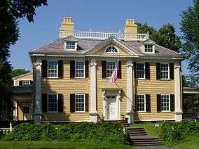
- Longfellow House–Washington's Headquarters National Historic Site (1759), former home of poet Henry Wadsworth Longfellow and headquarters of George Washington
- The Memorial Church of Harvard University (1932)
- Memorial Hall, Harvard University (1870–77)
- Middlesex County Courthouse (1814–48)
- Urban Rowhouse (1875)
- O'Reilly Spite House (1908), built to spite a neighbor who would not sell his adjacent land[126]
Contemporary architecture:
- Baker House dormitory, MIT, by Finnish architect Alvar Aalto, one of only two buildings by Aalto in the US
- Harvard Graduate Center/Harkness Commons, by The Architects Collaborative (TAC, with Walter Gropius)
- Carpenter Center for the Visual Arts, Harvard, the only building in North America by Le Corbusier
- Harvard's Science Center, Holyoke Center and Peabody Terrace, by Catalan architect and Dean of Harvard Graduate School of Design, Josep Lluís Sert
- Kresge Auditorium, MIT, by Eero Saarinen
- MIT Chapel, by Eero Saarinen
- Design Research Building, by Benjamin Thompson and Associates
- American Academy of Arts and Sciences, by Kallmann McKinnell and Wood, also architects of Boston City Hall
- Arthur M. Sackler Museum, Harvard, one of the few buildings in the US by James Stirling, winner of the Pritzker Prize (currently unoccupied, future unknown)
- Harvard Art Museums, renovation and major expansion of Fogg Museum building, completed in 2014 by Renzo Piano
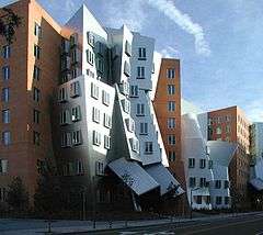
- Stata Center, MIT, by Frank Gehry
- Simmons Hall, MIT, by Steven Holl
Music
The city has an active music scene, from classical performances to the latest popular bands. Beyond performances at the colleges and universities, there are many venues in Cambridge including: The Middle East, Club Passim, The Plough and Stars, and the Nameless Coffeehouse.
Twin towns – Sister cities
Cambridge has six official sister cities with active relationships:[127]
 Coimbra, Portugal (est. June 1982)
 Gaeta, Latina, Lazio, Italy (est. December 1982)
 Tsukuba Science City, Ibaraki, Japan (est. October 1983)
 San José Las Flores, Chalatenango, El Salvador (est. March 1987)[128]
 Yerevan, Armenia (est. April 1987)[129][130][131]
 Galway, County Galway, Connacht, Ireland (est. March 1997)
Cambridge is in the process of developing a relationship with Les Cayes, Haiti.[132]
Cambridge has ten additional official sister cities which are not currently active:[127][133]
 Dublin, Leinster, Ireland (October 1983)
 Ischia, Naples, Campania, Italy (June 1984)
.svg.png) Catania, Catania, Sicily, Italy (February 1987)
Catania, Catania, Sicily, Italy (February 1987) Kraków, Lesser Poland Voivodeship, Poland (October 1989)
 Santo Domingo Oeste, Dominican Republic (May 2003)
 Southwark, Greater London, England, UK (June 2004)
 Yuseong District, Daejeon, Korea (February 2005)
 Haidian District, Beijing, China (March 2005)
 Cienfuegos, Cuba (May 2005)[134]
Notable people

- Ben Affleck, Academy Award-winning actor, director, screenwriter, and longtime friend of Matt Damon, raised in Cambridge.
- Casey Affleck, actor, and brother of Ben, lived in Cambridge.
- Bhumibol Adulyadej, the King of Thailand was born in Mount Auburn Hospital, the first king of a foreign country to be born in the United States.
- Dane Cook, actor and stand-up comedian, born in Cambridge
- Matt Damon, Academy Award-winning actor, screenwriter, and longtime friend of Ben Affleck, born and raised in Cambridge
- Bill De Blasio, politician and current Mayor of New York City, raised in Cambridge.
- Ephraim Emerton (1851–1935), medievalist historian and Harvard chair, lived in Cambridge.
- Mindy Kaling, actress, born in Cambridge
- John F. Kennedy, 35th President of the United States, lived in Cambridge.
- Conan O'Brien, comedian and television personality, lived in Cambridge.
See also
- Hezekiah Usher, first bookseller in the thirteen colonies.
- National Register of Historic Places listings in Cambridge, Massachusetts
Notes
References
Citations
- ↑ Cambridge Historical Commission. "Frequently Asked Questions". City of Cambridge. Retrieved September 11, 2016.
- ↑ Degler, Carl Neumann (1984). Out of Our Pasts: The Forces That Shaped Modern America. New York: HarperCollins. ISBN 978-0-06-131985-3. Retrieved September 9, 2009.
- ↑ Accessed December 1, 2016.
- ↑ "Cambridge (city) QuickFacts from the US Census Bureau". State & County QuickFacts. USDOC. July 8, 2014. Population, 2010.
- ↑ "Massachusetts QuickFacts from the US Census Bureau". State & County QuickFacts. USDOC. July 8, 2014.
- ↑ "Kendall Square Initiative". MIT. Retrieved December 1, 2016.
- ↑ Lelund Cheung. "When a neighborhood is crowned the most innovative square mile in the world, how do you keep it that way?". Boston Globe Media Partners, LLC. Retrieved December 1, 2016.
- 1 2 3 4 5 6 7 8 EB (1878).
- 1 2 Abbott, Rev. Edward (1880). "Cambridge". In Drake, Samuel Adams. History of Middlesex County, Massachusetts. 1. Boston: Estes and Lauriat. pp. 305–16. Retrieved December 26, 2008.
- ↑ Report on the Custody and Condition of the Public Records of Parishes. Boston: Massachusetts Secretary of the Commonwealth. 1889. p. 298. Retrieved December 24, 2008.
- ↑ Ritter, Priscilla R.; Thelma Fleishman (1982). Newton, Massachusetts 1679–1779: A Biographical Directory. New England Historic Genealogical Society.
- ↑ "History", Lexington Chamber of Commerce, 2007.
- ↑ William P., Marchione (2011). "A Short History of Allston-Brighton". Brighton-Allston Historical Society. Brighton Board of Trade. Archived from the original on February 20, 2012. Retrieved 21 December 2011.
- ↑ Staff writer (15 January 1874). "ANNEXATION AND ITS FRUITS". The New York Times. p. 4. Archived from the original on 15 January 1874.
- ↑ Staff writer (26 March 1892). "BOSTON'S ANNEXATION SCHEMES.; PROPOSAL TO ABSORB CAMBRIDGE AND OTHER NEAR-BY TOWNS". The New York Times. p. 11. Archived from the original on 27 March 1892. Retrieved 21 August 2010.
- ↑ Arthur Gilman, ed. (1896). The Cambridge of Eighteen Hundred and Ninety-six. Cambridge: Committee on the Memorial Volume. p. 8.
- ↑ Harvard News Office (May 2, 2002). "'''' historical calendar giving May 12, 1638, as date of name change; certain other sources say May 2, 1638, or late 1637". Harvard Gazette. Retrieved 2012-04-28.
- ↑ Hannah Winthrop Chapter, D.A.R. (1907). Historic Guide to Cambridge (Second ed.). Cambridge, Mass.: Hannah Winthrop Chapter, D.A.R. pp. 20–21.
On October 15, 1637, the Great and General Court passed a vote that: "The college is ordered to bee at Newetowne." In this same year the name of Newetowne was changed to Cambridge, ("It is ordered that Newetowne shall henceforward be called Cambridge") in honor of the university in Cambridge, England, where many of the early settlers were educated.
- ↑ "Descendants of the Great Migration". The Winthrop Society. Retrieved September 8, 2008.
- ↑ "Harvard Charter of 1650". Harvard University Archives. Retrieved September 7, 2013.
- ↑ "Chapter V: The University at Cambridge, and encouragement of literature, etc.". Constitution of the Commonwealth of Massachusetts. The General Court of Massachusetts. September 1, 1779. Retrieved December 13, 2009.
- ↑ The name of today's nearby Sheraton Commander Hotel refers to that event. ().
- ↑ EB (1911), p. 96.
- ↑ "Cambridge Considered: A Very Brief History of Cambridge, 1800–1900, Part I.".
- ↑ "Kennedy, F. A., Steam Bakery – Cambridge, MA – U.S. National Register of Historic Places". waymarking.com.
- ↑ "Candy Land: The History of Candy Making in Cambridge, MA – Squirrel Brand Nuts". cambridgehistory.org.
- ↑ "Candy Land: The History of Candy Making in Cambridge, MA – George Close Company". cambridgehistory.org.
- ↑ "Candy Land: The History of Candy Making in Cambridge, MA – Daggett Chocolate". cambridgehistory.org.
- ↑ "Candy Land: The History of Candy Making in Cambridge, MA – Fox Cross Co.". cambridgehistory.org.
- 1 2 "Candy Land: The History of Candy Making in Cambridge, MA – James O. Welch". cambridgehistory.org.
- ↑ http://www.betaboston.com/news/2016/03/17/how-cambridge-became-the-life-sciences-capital/
- ↑ "City Council Policy Order Resolution O-16". City Of Cambridge. May 8, 2006.
- ↑ Mason, Melanie; Mishak, Michael J.; Powers, Ashley (April 21, 2013). "In immigrant-rich Cambridge, arrest baffles locals". Los Angeles Times.
- ↑ No Writer Attributed (September 18, 1969). ""Cambridge: A City of Squares" Harvard Crimson, Sept. 18, 1969". Thecrimson.com. Retrieved 2012-04-28.
- ↑ "Cambridge Journal: Massachusetts City No Longer in Boston's Shadow". Travelwritersmagazine.com. Archived from the original on 2012-04-17. Retrieved 2012-04-28.
- ↑ [email protected], Natalie Handy. "Area Four in Cambridge renamed 'The Port'". Cambridge Chronicle & Tab. Retrieved 2016-03-20.
- ↑ "City of Cambridge map" (PDF). City of Cambridge. 2007.
- ↑ "TOTAL POPULATION (P1), 2010 Census Summary File 1". American FactFinder, All County Subdivisions within Massachusetts. United States Census Bureau. 2010.
- ↑ "Massachusetts by Place and County Subdivision - GCT-T1. Population Estimates". United States Census Bureau. Retrieved July 12, 2011.
- ↑ "1990 Census of Population, General Population Characteristics: Massachusetts" (PDF). US Census Bureau. December 1990. Table 76: General Characteristics of Persons, Households, and Families: 1990. 1990 CP-1-23. Retrieved July 12, 2011.
- ↑ "1980 Census of the Population, Number of Inhabitants: Massachusetts" (PDF). US Census Bureau. December 1981. Table 4. Populations of County Subdivisions: 1960 to 1980. PC80-1-A23. Retrieved July 12, 2011.
- ↑ "1950 Census of Population" (PDF). Bureau of the Census. 1952. Section 6, Pages 21-10 and 21-11, Massachusetts Table 6. Population of Counties by Minor Civil Divisions: 1930 to 1950. Retrieved July 12, 2011.
- ↑ "1920 Census of Population" (PDF). Bureau of the Census. Number of Inhabitants, by Counties and Minor Civil Divisions. Pages 21-5 through 21-7. Massachusetts Table 2. Population of Counties by Minor Civil Divisions: 1920, 1910, and 1920. Retrieved July 12, 2011.
- ↑ "1890 Census of the Population" (PDF). Department of the Interior, Census Office. Pages 179 through 182. Massachusetts Table 5. Population of States and Territories by Minor Civil Divisions: 1880 and 1890. Retrieved July 12, 2011.
- ↑ "1870 Census of the Population" (PDF). Department of the Interior, Census Office. 1872. Pages 217 through 220. Table IX. Population of Minor Civil Divisions, &c. Massachusetts. Retrieved July 12, 2011.
- ↑ "1860 Census" (PDF). Department of the Interior, Census Office. 1864. Pages 220 through 226. State of Massachusetts Table No. 3. Populations of Cities, Towns, &c. Retrieved July 12, 2011.
- ↑ "1850 Census" (PDF). Department of the Interior, Census Office. 1854. Pages 338 through 393. Populations of Cities, Towns, &c. Retrieved July 12, 2011.
- ↑ "1950 Census of Population" (PDF). 1: Number of Inhabitants. Bureau of the Census. 1952. Section 6, Pages 21–7 through 21–09, Massachusetts Table 4. Population of Urban Places of 10,000 or more from Earliest Census to 1920. Retrieved July 12, 2011.
- ↑ "Census of Population and Housing". Census.gov. Archived from the original on May 11, 2015. Retrieved June 4, 2015.
- 1 2 "Cambridge (city), Massachusetts". State & County QuickFacts. U.S. Census Bureau.
- 1 2 3 4 "Massachusetts – Race and Hispanic Origin for Selected Cities and Other Places: Earliest Census to 1990". U.S. Census Bureau.
- 1 2 From 15% sample
- ↑ "American FactFinder". United States Census Bureau. Archived from the original on September 11, 2013. Retrieved 2008-01-31.
- ↑ "QT-P8: Race Reporting for the Asian Population by Selected Categories: 2010". factfinder2.census.gov. 2010 Census. Retrieved 1 June 2014.
- ↑ "U.S. Census, 2000". Factfinder.census.gov. Retrieved 2012-04-28.
- ↑ "Study Ranks America's Most Liberal and Conservative Cities". Govpro.com. August 16, 2005. Archived from the original on 2008-09-05. Retrieved 2012-04-28.
- ↑ "People's Republic, the". The Hub.
- ↑ "FY16 Property Tax Information – City of Cambridge, Massachusetts". Cambridgema.gov. Retrieved 2016-01-23.
- ↑ "Cambridge Earns Three Triple A Ratings for Fiscal Management for 15th Consecutive Year – City of Cambridge, Massachusetts". www.cambridgema.gov. Retrieved February 17, 2015.
- ↑ "SELECTED ECONOMIC CHARACTERISTICS 2009–2013 American Community Survey 5-Year Estimates". U.S. Census Bureau. Retrieved 2015-01-12.
- ↑ "ACS DEMOGRAPHIC AND HOUSING ESTIMATES 2009–2013 American Community Survey 5-Year Estimates". U.S. Census Bureau. Retrieved 2015-01-12.
- ↑ "HOUSEHOLDS AND FAMILIES 2009–2013 American Community Survey 5-Year Estimates". U.S. Census Bureau. Retrieved 2015-01-12.
- ↑ "Registered Voters and Party Enrollment as of February 1, 2015" (PDF). Massachusetts Elections Division. Retrieved November 4, 2015.
- ↑ "State Rep Districts". Geographic Information System. City of Cambridge. Retrieved July 2014. Check date values in:
|access-date=(help) - ↑ "Index of Legislative Representation by City and Town, from". Mass.gov. Retrieved 2012-04-28.
- ↑ "Proportional Representation Voting in Cambridge". Cambridgema.gov. Retrieved 2012-04-28.
- ↑ "Plan E" (PDF). City of Cambridge.
- ↑ "DePasquale era begins with councillor vote affirming multi-year city manager contract | Cambridge Day". Retrieved 2016-11-22.
- ↑ Saltzman, Amy. "BREAKING: Rossi to retire as Cambridge city manager in June". Cambridge Chronicle & Tab. Retrieved 2016-03-11.
- ↑ "Cambridge city manager's salary almost as much as Obama's pay". Wicked Local: Cambridge. August 11, 2011. Archived from the original on December 30, 2011. Retrieved December 30, 2011.
- ↑ "City of Cambridge – City Council (2014–2015)". Cambridgema.gov. Retrieved 2014-01-07.
- ↑ ewelin (September 5, 2007). "David P. Maher Elected to fill Michael Sullivan's Vacated City Council Seat • Cambridge Highlands Neighborhood Association". Cambridgehighlands.com. Retrieved 2012-04-28.
- ↑ "Station H-5, SP Brighton". Archived from the original on December 4, 2011.
- ↑ "Station H-4, SP Boston". Archived from the original on December 4, 2011.
- ↑ "City of Cambridge Fire Department: About Us". cambridgema.gov. Retrieved 2015-01-18.
- ↑ "Cambridge Watershed Lands & Facilities". .cambridgema.gov. Retrieved 2012-04-28.
- ↑ "Water supply system" (PDF). Retrieved 2012-04-28.
- ↑ "Is Fresh Pond really used for drinking water?". Cambridge Water Department. Archived from the original on March 2, 2013.
- ↑ Moskowitz, Eric (February 14, 2008). "Court move a hassle for commuters". The Boston Globe. Retrieved July 25, 2009.
In a little more than a month, Middlesex Superior Court will open in Woburn after nearly four decades at the Edward J. Sullivan Courthouse in Cambridge. With it, the court will bring the roughly 500 people who pass through its doors each day – the clerical staff, lawyers, judges, jurors, plaintiffs, defendants, and others who use or work in the system.
- ↑ Breitrose, Charlie (July 7, 2009). "Cambridge's Middlesex Jail, courts may be shuttered for good". Wicked Local News: Cambridge. Archived from the original on 2011-05-13. Retrieved July 25, 2009.
The courts moved out of the building to allow workers to remove asbestos. Superior Court moved to Woburn in March 2008, and in February, the Third District Court moved to Medford.
- ↑ "Schools". Retrieved January 6, 2013.
- ↑ "Cambridge Public Schools at a Glance 2012–2013" (PDF). Retrieved January 6, 2013.
- ↑ "The Benjamin Banneker Charter Public School". Banneker.org. March 1, 2012. Retrieved 2012-04-28.
- ↑ "Community Charter School of Cambridge". Ccscambridge.org. Retrieved 2012-04-28.
- ↑ http://www.fayerweather.org/
- 1 2 "Top 25 Cambridge Employers: 2008". City of Cambridge. Archived from the original on March 20, 2012.
- ↑ Casey Ross; Robert Weisman (October 27, 2010). "Novartis doubles plan for Cambridge". The Boston Globe. Archived from the original on 2011-08-10. Retrieved April 12, 2011.
Already Cambridge's largest corporate employer, the Swiss firm expects to hire an additional 200 to 300 employees over the next five years, bringing its total workforce in the city to around 2,300. Novartis's global research operations are headquartered in Cambridge, across Massachusetts Avenue from the site of the new four-acre campus.
- ↑ Ross, Casey; Weisman, Robert (October 27, 2010). "Novartis Doubles Plan for Cambridge". The Boston Globe. Retrieved February 23, 2012.
- ↑ Arnold, Chris (2013-10-31). "What Happens When The Pace Of Startups Slows Down". NPR. Retrieved 6 November 2013.
- ↑ Kirsner, Scott (2012-09-20). "LabCentral, a new hatchery for science-oriented startups, is seeking space in Kendall Square". Boston Globe. Retrieved 16 August 2013.
- ↑ "Google Offices". Google.com. Retrieved 2012-07-18.
- ↑ "Philips Research North American Headquarter Moves to Cambridge". fortune.com. Retrieved 2015-09-29.
- ↑ Huang, Gregory. "Hewlett-Packard Expands to Cambridge via Vertica's "Big Data" Center".
- ↑ "Staples to bring e-commerce office to Cambridge's Kendall Square".
- ↑ "Amazon Seeks Brick-And-Mortar Presence In Boston Area".
- ↑ Pierce, Kathleen (September 16, 2011). "Stars of invention". The Boston Globe. Retrieved October 1, 2011.
- ↑ "2014 Top 25 Employers – CDD – City of Cambridge, Massachusetts". Cambridgema.gov. 2014. Retrieved 2012-04-28.
- ↑ "> Schedules & Maps > Subway > Alewife Station". MBTA. Retrieved 2015-06-04.
- ↑ Staff writer (January 1, 2013). "Charles River TMA Members". CRTMA. Archived from the original on November 27, 2012. Retrieved January 1, 2013.
- ↑ "Dr. Paul Dudley White Bikepath". Retrieved 2012-04-28.
- ↑ "Sidewalk Bicycling Banned Areas – Cambridge Massachusetts". Cambridgema.gov. Archived from the original on 2012-04-19. Retrieved 2012-04-28.
- ↑ "Traffic Regulations for Cyclists – Cambridge Massachusetts". Cambridgema.gov. May 1, 1997. Archived from the original on 2012-05-21. Retrieved 2012-04-28.
- ↑ MacLaughlin, Nina (2006). "Boston Can Be Bike City...If You Fix These Five Big Problems". The Phoenix – Bicycle Bible 2006. Archived from the original on August 11, 2011.
- ↑ Fiske, Brian. "Urban Treasures". Bicycling Magazine.
- ↑ Katie Zezima (August 9, 2009). "Boston Tries to Shed Longtime Reputation as Cyclists' Minefield". The New York Times. Retrieved August 16, 2009.
- ↑ "A Future Best City: Boston". Rodale Inc. Archived from the original on 2010-02-11. Retrieved August 16, 2009.
- ↑ "Boston gear up for influx of new bicycle riders". The Boston Globe. July 13, 2011. Retrieved July 15, 2011.
- ↑ McGrory Brian (July 15, 2011). "Make Boston bicycle-free". The Boston Globe. Retrieved July 15, 2011.
- ↑ "Drivers, bicyclists clash on road sharing". Turner Broadcasting System. October 18, 2010. Retrieved July 15, 2011.
- ↑ Filipov, David (July 29, 2009). "Hub's bike routes beckon, white knuckles and all". The Boston Globe. Retrieved July 15, 2011.
- ↑ Cambridge, City of. "Bicycle Committee - City of Cambridge, Massachusetts". www.cambridgema.gov. Retrieved 2016-04-17.
- ↑ "LivableStreets: Rethinking Urban Transportation". LivableStreets Alliance. Retrieved 7 March 2013.
- ↑ "The Carfree Census Database: Result of search for communities in any state with population over 100,000, sorted in descending order by % Pedestrian Commuters". Bikesatwork.com. Retrieved 2012-04-28.
- ↑ Thomas, Sarah (October 19, 2010). "NYC-bound buses will roll from Newton, Cambridge". Boston.com. Retrieved 2012-04-28.
- ↑ Staff writer (2013). "Cable Television in the City of Cambridge". Cambridge Consumers' Council. Retrieved April 3, 2013.
Comcast is currently the only cable operator that has sought a license with Cambridge. The City of Cambridge has approached other operators, more than once, about seeking a license to operate a cable TV system in Cambridge, but they have informed us that Cambridge is not currently part of their business plan; however, City officials stand ready to negotiate with any willing operator.
- ↑ "Cable TV franchise agreements in Massachusetts". Commonwealth of Massachusetts Office of Consumer Affairs & Business Regulation (OCABR).
- ↑ "Broadband Task Force – City Manager's Office – City of Cambridge, Massachusetts". www.cambridgema.gov. Retrieved 2015-10-30.
- ↑ "CAC Public Art Program". Cambridgema.gov. March 13, 2007. Retrieved 2012-04-28.
- ↑ "Office for the Arts at Harvard: Public Art". Ofa.fas.harvard.edu. Retrieved 2012-04-28.
- ↑ "MIT Public Art Collection Map". Listart.mit.edu. Retrieved 2012-04-28.
- ↑ "Honk Fest".
- ↑ "The Cambridge Historical Society".
- ↑ "Street Arts & Buskers Advocates".
- ↑ "Street Arts and Buskers Advocates". Harvardsquare.com. Retrieved 2012-04-28.
- ↑ Heggemeyer, Amy (2006). "Elizabeth Tracy". WPA Murals. Washington, D.C.: General Services Administration. Retrieved 28 April 2016.
- ↑ Bloom, Jonathan (February 2, 2003). "Existing by the Thinnest of Margins. A Concord Avenue Landmark Gives New Meaning to Cozy". Boston Globe – via HighBeam. (subscription required (help)).
- 1 2 "Cambridge Peace Commission :: Sister Cities". cambridgema.gov.
- ↑ "Cambridge Peace Commission :: Sister City San José Las Flores, El Salvador". cambridgema.gov.
- ↑ "Cambridge Peace Commission :: Sister City Yerevan, Armenia". cambridgema.gov.
- ↑ "Yerevan – Twin Towns & Sister Cities". Yerevan Municipality Official Website. © 2005—2013 www.yerevan.am. Retrieved 2013-11-04.
- ↑ ԵՐԵՎԱՆԻ ՔԱՂԱՔԱՊԵՏԱՐԱՆՊԱՇՏՈՆԱԿԱՆ ԿԱՅՔ [Yerevan expanding its international relations] (in Armenian). yerevan.am. Archived from the original on 2013-05-12. Retrieved 2013-08-05.
- ↑ "Cambridge Peace Commission :: the Cambridge-Haiti Sister City Committee". cambridgema.gov.
- ↑ "A message from the Peace Commission". Archived from the original on February 2, 2015.
- ↑ "Cambridge Peace Commission :: Sister City Cienfuegos, Cuba". cambridgema.gov.
Bibliography
- "Cambridge", Encyclopædia Britannica, 9th ed., Vol. IV, New York: Charles Scribner's Sons, 1878, p. 732.
- "Cambridge", Encyclopædia Britannica, 11th ed., Vol. V, Cambridge: Cambridge University Press, 1911, pp. 95–96.
- History of Middlesex County, Massachusetts, Volume 1 (A-H), Volume 2 (L-W) compiled by Samuel Adams Drake, published 1879–1880.
- Cambridge article by Rev. Edward Abbott in volume 1, pages 305–358.
- Eliot, Samuel Atkins. A History of Cambridge, Massachusetts: 1630–1913. Cambridge: The Cambridge Tribune, 1913.
- Hiestand, Emily. "Watershed: An Excursion in Four Parts" The Georgia Review Spring 1998 pages 7–28
- Paige, Lucius. History of Cambridge, Massachusetts: 1630–1877. Cambridge: The Riverside Press, 1877.
- Survey of Architectural History in Cambridge: Mid Cambridge, 1967 ISBN 0-262-53012-0, Cambridge Historical Commission, Cambridge, Mass.
- Survey of Architectural History in Cambridge: Cambridgeport, 1971 ISBN 0-262-53013-9, Cambridge Historical Commission, Cambridge, Mass.
- Survey of Architectural History in Cambridge: Old Cambridge, 1973 ISBN 0-262-53014-7, Cambridge Historical Commission, Cambridge, Mass.
- Survey of Architectural History in Cambridge: Northwest Cambridge, 1977 ISBN 0-262-53032-5, Cambridge Historical Commission, Cambridge, Mass.
- Survey of Architectural History in Cambridge: East Cambridge, 1988 (revised) ISBN 0-262-53078-3, Cambridge Historical Commission, Cambridge, Mass.
- Sinclair, Jill (April 2009). Fresh Pond: The History of a Cambridge Landscape. Cambridge, Mass.: MIT Press. ISBN 978-0-262-19591-1.
- Seaburg, Alan (2001). Cambridge on the Charles. Billerica, Massachusetts: Anne Miniver Press. ISBN 978-0-9625794-9-3.
External links
| Wikimedia Commons has media related to Cambridge, Massachusetts. |
| Wikivoyage has a travel guide for Cambridge (Massachusetts). |
| Wikisource has the text of a 1911 Encyclopædia Britannica article about Cambridge, Massachusetts. |
- Official website
- Cambridge Office for Tourism
- Cambridge Public Schools Department
- Data for the Cambridge Public Schools, National Center for Education Statistics
- Cambridge Maps
- Cambridge, Massachusetts at DMOZ
Boston (capital) | |
| Topics |
|
| Society | |
| Regions | |
| Counties | |
| Cities |
|
| Topics | |||||||||||
|---|---|---|---|---|---|---|---|---|---|---|---|
| States | |||||||||||
| Major cities | |||||||||||
| State capitals | |||||||||||
| Transportation |
| ||||||||||
| |||||||||||
| ||
| ||