Maynard, Massachusetts
| Maynard, Massachusetts | ||
|---|---|---|
| Town | ||
|
The intersection of Main and Nason Streets in downtown Maynard. | ||
| ||
|
Motto: Progressus cum Stabilitate (Latin) "Progress with Stability" | ||
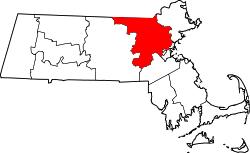
 Location in Middlesex County in Massachusetts | ||
| Coordinates: 42°26′00″N 71°27′00″W / 42.43333°N 71.45000°WCoordinates: 42°26′00″N 71°27′00″W / 42.43333°N 71.45000°W | ||
| Country | United States | |
| State | Massachusetts | |
| County | Middlesex | |
| Settled | 1638 | |
| Incorporated | 1871 | |
| Government | ||
| • Type | Open town meeting | |
| Area | ||
| • Total | 5.4 sq mi (13.9 km2) | |
| • Land | 5.2 sq mi (13.6 km2) | |
| • Water | 0.1 sq mi (0.3 km2) | |
| Elevation | 186 ft (57 m) | |
| Population (2010) | ||
| • Total | 10,106 | |
| • Density | 1,957.1/sq mi (748.3/km2) | |
| Time zone | Eastern (UTC-5) | |
| • Summer (DST) | Eastern (UTC-4) | |
| ZIP code | 01754 | |
| Area code(s) | 351 / 978 | |
| FIPS code | 25-39625 | |
| GNIS feature ID | 0618229 | |
| Website | web.maynard.ma.us/ | |


Maynard is a town in Middlesex County, Massachusetts, United States. The town is located 25 miles west of Boston, in the MetroWest region of Massachusetts. As of the 2010 census, the town population was 10,106.
Maynard was the site of the Assabet Woolen Mill, which produced wool fabrics near the Assabet River for over 100 years, from 1846 to 1950, under various owners. The American Powder Mills complex extending downstream along the river manufactured gunpowder from 1835 to 1940.[1] Digital Equipment Corporation (DEC) was headquartered in the mill buildings in Maynard from 1957 until 1998, when it was bought by Compaq and subsequently closed. The mill complex operated as Clock Tower Place, 2000-2015, renamed "mill&main" under new ownership as of 2015; The mill complex is currently renting space to office and light industry businesses. In the future, the complex will include retail areas and restaurants. At present, there are no plans for residences.
History
Maynard, located on the Assabet River, was incorporated as an independent municipality in 1871. Prior to that it was known as "Assabet Village" but was legally still part of the towns of Stow and Sudbury. There were some exploratory town-founding rumblings in 1870, followed by a petition to the Commonwealth of Massachusetts, filed January 26, 1871. State approval was granted April 19, 1871. In return, the new town paid Sudbury and Stow about $23,600 and $8,000 respectively. Sudbury got more money because it owned shares in the railroad, plus the wool mill and paper mill were in Sudbury, and more land came from Sudbury. The population of the newly formed town - at 1,820 - was larger than either of its parent towns.[2]
Formation of new towns carved out of older ones was not unique to Maynard. Hudson, with its cluster of leather processing and shoe-making mills, seceded from Marlborough and Stow in 1866. In fact, the originally much larger Stow formed in 1683 lost land to Harvard, Shirley, Boxborough, Hudson and Maynard. The usual reason to petition the State's Committee on Towns was that a fast-growing population cluster - typically centered around mills - was too far from the schools, churches and Meeting Hall of the parent town.[3]
The community was named after Amory Maynard, the man who, with William Knight, had bought water-rights to the Assabet River, installed a dam and built a large carpet mill in 1846-47. The community grew along with the Assabet Woolen Mill and made the highest percentage of wool for U.S. military uniforms for the Civil War. The woolen mill went bankrupt in 1898; it was purchased in 1899 by the American Woolen Company, a multi-state corporation, which greatly modernized and expanded the mill complex from 1900 through 1919. From 1910 through 1940, the population of Maynard was larger than that of Acton, Stow and Sudbury, combined.[4]
There was an attempt in 1902 to change the town's name from "Maynard" to "Assabet". Some townspeople were upset that Amory Maynard had not left the town a gift before he died in 1890, and more were upset that Lorenzo Maynard, Amory's son, had withdrawn his own money from the Mill before it went bankrupt in 1898. The Commonwealth of Massachusetts decided to keep the name as "Maynard" without allowing the topic to come to a vote by the residents.[5][6]
After the woolen mill finally shut down in 1950, local businessmen bought the property and began leasing it as office or manufacturing space. Digital Equipment Corporation (DEC) moved into the complex in 1957, initially renting only 8,600 square feet. The company grew and grew until it bought the entire complex in 1974, which led to Maynard's nickname "Mini Computer Capital of the World". DEC remained in Maynard until 1998 when it was purchased by Compaq, which was itself later bought out by Hewlett Packard in 2002.[7] The mill complex was nearly empty for almost ten years.
"The Mill", as locals call it, was renovated in the late 1990s and renamed "Clock Tower Place" (2000-2015), and then renamed "mill&main" by new owners in 2016. The site houses many businesses, including the headquarters of Powell Flutes and up to 2014 Monster.com. The mill complex is also home to the oldest, still-working, hand-wound clock in the country (see image). The clock tower was constructed in 1892 by Lorenzo Maynard as a gift to the town. The weights that power the E. Howard & Co. tower clock and bell-ringing mechanisms are wound up once a week - more than 6,000 times since the clock was installed. The process takes one to two hours. The four clock faces have always been illuminated by electric lights.
Glenwood Cemetery, located south of downtown Maynard, was added to the National Register of Historic Places in 2004.
The Maynard Family

John Maynard, born 1598, came over from England with his wife Elizabeth (Ashton) Maynard around 1635. Five generations later, Isaac Maynard was operating a mill in Marlborough. When he died in 1820 at age 41 his teenage son, Amory Maynard, took over the family business. The City of Boston bought Amory's water rights to Fort Meadow Pond in 1846. He partnered with William Knight to start up a woolen mill operation on the Assabet River. Amory and his wife Mary (Priest) Maynard had three sons: Lorenzo (1829-1904), William (1833-1906) and Harlan (1843-1861). Amory managed the mill from 1847-1885 (Knight retired in 1852). Lorenzo took over from 1885 to 1898. William had less to do with the family business - he lived in Boston a while, then Maynard again, then off to Pasadena, California in 1885 for reasons of ill health (possibly tuberculosis). He recovered and moved back east to Worcester in 1888 for the remainder of his life. Harlan died at age 18.
Lorenzo married Lucy Davidson and had five children, but all of them died without issue - the four daughters passing away before their parents. William married Mary Adams and had seven children. Descendants of two - Harlan James and Lessie Louise - are alive today, but not living locally. William's granddaughter, Mary Augusta Sanderson, who died in 1947, was the last descendant to live in Maynard.
The Maynard Crypt is a prominent feature on the north side of Glenwood Cemetery, within sight of passers-by on Route 27. It is an imposing earth-covered mound with a granite facade facing the road. The mound is 90 feet across and about 12 feet tall. The stonework facade is approximately 30 feet across. The ceiling of the crypt has a glass skylight surmounted by an exterior cone of iron grillwork. The granite lintel above the door reads "MAYNARD." Chiseled above the lintel are the year 1880 and the Greek letters Alpha and Omega entwined with a Fleur-de-lis Cross. Amory Maynard, his wife, Mary, and twenty of their descendants are interred in the crypt. At one point in time Amory's first son, Lorenzo, along with Lorenzo's wife and their four daughters, were also in the crypt, but in October 1904 Lorenzo's son arranged to have his six family members moved to a newly constructed mausoleum in Mount Auburn Cemetery, Cambridge, Massachusetts. Lorenzo had contracted for the mausoleum while still alive but died before it was completed. William, Amory's second son, was buried in the Hope Cemetery, Worcester, along with his wife and four of their seven children.

Geography
Maynard is located at 42°25′50″N 71°27′21″W / 42.43056°N 71.45583°W (42.430781, -71.455943).[8]
According to the United States Census Bureau, the town has a total area of 5.4 square miles (13.9 km²), of which 5.2 square miles (13.6 km²) is land and 0.1 square miles (0.3 km²), or 2.42%, is water. Average elevation is roughly 200 feet (~61 m) above sea level; the highest point is Summer Hill, elevation 358 feet (109.1 m); the lowest is the Maynard/Acton border next to the Assabet River, at 145 feet (44.2 m).
The Assabet River flows through Maynard from west to east, spanned by seven road bridges and one foot bridge. The river's vertical drop from the Stow border to the Acton border is 30 feet (9 m). Initially, this was sufficient to hydropower the wool and paper mills, but both later added coal-powered steam engines. Average flow in the river is 200 cubic feet per second. However, in summer months the average drops to under 100 cfs. The flood of March 2010 reached 2,500 cfs. Recent, monthly and annual riverflow data is available from the U.S. Geological Service.[9]
Average precipitation, long-term, is 43 inches (1,092 mm) per year, which includes 44 inches (112 cm) of snow. (The snow-to-water conversion is roughly 8 inches or 20 centimetres snow melts to one inch of water.) However, there has been a trend over the past 100 years of increasing precipitation, so the more recent average is closer to 50 inches per year (127 cm/year), and six of the snowiest winters on record have been since 1992-93.
Maynard borders the towns of Acton, Concord, Sudbury and Stow.
Transportation
The nearest rail station is in South Acton on the MBTA Commuter Rail Fitchburg Line. Connection to Route 2 is four miles. Connections to I-95 in the east and I-495 in the west are both 8 miles.
Construction started on a 3.4 four mile portion of the Assabet River Rail Trail in 2016. When completed in 2018, will run from the South Acton train station at the north end, though the center of Maynard, and along the Assabet River to the Maynard:Stow border, where, via White Pond Road, there is access to the Assabet River National Wildlife Refuge. ARRT will be open for non-motorized transportation (skateboards, bicycles, etc.). See www.ARRTinc.org for construction updates.
Demographics
| Historical population | ||
|---|---|---|
| Year | Pop. | ±% |
| 1880 | 2,201 | — |
| 1890 | 2,700 | +22.7% |
| 1900 | 3,142 | +16.4% |
| 1910 | 6,390 | +103.4% |
| 1920 | 7,086 | +10.9% |
| 1930 | 7,156 | +1.0% |
| 1940 | 6,812 | −4.8% |
| 1950 | 6,978 | +2.4% |
| 1960 | 7,695 | +10.3% |
| 1970 | 9,710 | +26.2% |
| 1980 | 9,590 | −1.2% |
| 1990 | 10,325 | +7.7% |
| 2000 | 10,433 | +1.0% |
| 2010 | 10,106 | −3.1% |
| Source: United States Census records and Population Estimates Program data.[10][11][12][13][14][15][16] | ||
The 2010 census put the population at 10,106 residents, a 3% decline from 2000.
As of the census[17] of 2000, there had been 10,433 people, 4,292 households, and 2,811 families residing in the town. The population density was 1,990.6 people per square mile (768.7/km²). There were 4,406 housing units, at an average density of 840.7 per square mile (324.6/km²). The racial makeup of the town was 94.64% White, 1.04% Black or African American, 0.27% Native American, 1.62% Asian, 1.18% from other races, and 1.26% from two or more races. Hispanic or Latino of any race were 2.78% of the population. 23.3% were of Irish, 15.5% Italian, 10.3% English, 6.0% German, 5.1% French and 5.1% Polish ancestry according to Census 2000.
There were 4,292 households out of which 28.9% had children under the age of 18 living with them, 52.4% were married couples living together, 9.9% had a female householder with no husband present, and 34.5% were non-families. 28.5% of all households were made up of individuals and 10.3% had someone living alone who was 65 years of age or older. The average household size was 2.43 and the average family size was 3.02.
The population distribution was 23.4% under the age of 18, 5.4% from 18 to 24, 35.1% from 25 to 44, 23.8% from 45 to 64, and 12.2% who were 65 years of age or older. The median age was 38 years. For every 100 females there were 91.6 males. For every 100 females age 18 and over, there were 87.0 males.
The median income for a household in the town was $60,812, and the median income for a family was $71,875. Males had a median income of $49,279 versus $36,609 for females. The per capita income for the town was $27,016. About 3.8% of families and 5.6% of the population were below the poverty line, including 7.4% of those under age 18 and 6.0% of those age 65 or over.
Education
Maynard has three public schools on adjoining campuses off Route 117. There is an adult education program. One private school offers a classical Christian education program for grades K through 8.
- Green Meadow School: grades Pre-K through 3; 2011-12 enrollment: 526 students; opened for start of 1956-57 school year; major expansion 1988.[18]
- Fowler School: grades 4 through 7; 2011-12 enrollment: 507 students; opened January 2001.[19]
- Maynard High School: grades 8 through 12; 2011-12 enrollment: 352 students; New high school opened for start of 2013-14 school year.[20]
- Hudson Maynard Adult Learning Center offers free adult literacy classes: English Spoken with Other Languages (ESOL) and GED preparation classes.[21]
- The Imago School teaches grades K through 8; enrollment: 90 students; classical Christian education program; opened in 1980.[22]
Government
Maynard uses the Open Town Meeting form of town government popular in small to mid-sized Massachusetts towns. Anyone may attend a town meeting, but only registered voters may vote. Before the meeting, a warrant is distributed to households in Maynard and posted on the town's website. Each article in the warrant is debated and voted on separately.
A minimum of 75 registered voters is required as a quorum to hold a town meeting and vote on town business. The quorum requirement was reduced from 100 in 2009 because at times, meetings were failing to achieve a quorum. Important budgetary issues approved at a town meeting must be passed by a subsequent ballot vote.
Maynard's elected officials are a five-member Board of Selectman. Each member is elected to a three-year term. Also filled by election are the School Committee, Housing Authority, Library Trustees and a Moderator to preside over the town meetings. Positions filled by appointment include the Town Administrator and other positions.
Details of government are in the Maynard Town Charter and Town of Maynard By-Laws, both documents posted at www.townofmaynard-ma.gov/gov/charter-and-bylaws.
Places of worship
- Baha'i Faith Devotional Meetings.
- First Bible Baptist Church.
- Holy Annunciation Orthodox Church, services started 1915; church built 1916.
- Kingdom Hall of Jehovah's Witnesses, Hall built 1967.
- Mission Evangelical Congregational Church, services started 1906; church built 1913.
- New Hope Fellowship Church of the Nazarene, 51 Old Marlboro Road.
- St. Bridget Roman Catholic Church, services started 1865 in a church on Main Street; cornerstone for current church laid 1881 and church dedicated September 21, 1884.
- St. Mary's Indian Orthodox Church, consecrated 2003; building had been St. Casimir Roman Catholic Church (1928-1999), and before that the power station for the Concord, Maynard and Hudson electric trolley (1901-1923).
- St. Stephen's Knanaya Church.
- Union Congregational Church, services started 1852; church built 1853.
History of former places of worship:
- Congregation Rodoff Shalom 1921-1980; Acton Street. Building status: private residence.
- St. John's Finnish Evangelical Lutheran Church 1907-1967; Glendale Street. Building status: private residence.
- St. Casimir Roman Catholic Church 1928-1999. Parish established 1912, holding services at St. Bridget until moving to own building in 1928. Building status: St. Mary's Indian Orthodox Church since 2003.
- St. George's Episcopal Church 1895-2006; Summer Street. Building status: private residence.
- United Methodist Church of Maynard 1895-2014; Main Street. Parish established 1867, church built 1895, closed May 2014. Building status: empty.
Notable people
- Julie Berry, author of children's books[23]
- John "Red" Flaherty, baseball umpire
- Michael Goulian, Airshow performer and RedBull Air Race pilot
- Herb Greene, noted photographer of the Grateful Dead
- Leo Mullin, CEO of Delta Airlines 1997-2003[24]
- Frank Murray, college football coach
- Jarrod Shoemaker, Olympic triathlete
- William G. Tapply, author
See also
References
- ↑ Mark, David A. (2014). Hidden History of Maynard. The History Press. pp. 78–82. ISBN 1626195412.
- ↑ Sheridan, Ralph (1971). A History of Maynard 1871-1971. Town of Maynard Historical Committee.
- ↑ Fuller, Ralph. (2009). Stow Things. Stow Historical Publishing Company.
- ↑ A History of The Mill. Web.maynard.ma.us (2000-11-27). Retrieved on 2013-07-17.
- ↑ Gutteridge, William H. (1921). A Brief History of the Town of Maynard, Massachusetts. Maynard, MA: Town of Maynard.
- ↑ Mark, David. (2012-01-26) Maynard Name Change - Part 1. Maynard Life Outdoors. Retrieved on 2013-07-17.
- ↑ Earls, Alan R. (2004). Digital Equipment Corporation. Mount Pleasant, SC: Arcadia Publishing. ISBN 978-0-7385-3587-6
- ↑ "US Gazetteer files: 2010, 2000, and 1990". United States Census Bureau. 2011-02-12. Retrieved 2011-04-23.
- ↑ USGS Current Conditions for USGS 01097000 ASSABET RIVER AT MAYNARD, MA. Waterdata.usgs.gov. Retrieved on 2013-07-17.
- ↑ "TOTAL POPULATION (P1), 2010 Census Summary File 1, All County Subdivisions within Massachusetts". United States Census Bureau. Retrieved September 13, 2011.
- ↑ "Massachusetts by Place and County Subdivision - GCT-T1. Population Estimates". United States Census Bureau. Retrieved July 12, 2011.
- ↑ "1990 Census of Population, General Population Characteristics: Massachusetts" (PDF). US Census Bureau. December 1990. Table 76: General Characteristics of Persons, Households, and Families: 1990. 1990 CP-1-23. Retrieved July 12, 2011.
- ↑ "1980 Census of the Population, Number of Inhabitants: Massachusetts" (PDF). US Census Bureau. December 1981. Table 4. Populations of County Subdivisions: 1960 to 1980. PC80-1-A23. Retrieved July 12, 2011.
- ↑ "1950 Census of Population" (PDF). Volume 1: Number of Inhabitants. Bureau of the Census. 1952. Section 6, Pages 21-10 and 21-11, Massachusetts Table 6. Population of Counties by Minor Civil Divisions: 1930 to 1950. Retrieved July 12, 2011.
- ↑ "1920 Census of Population" (PDF). Bureau of the Census. Number of Inhabitants, by Counties and Minor Civil Divisions. Pages 21-5 through 21-7. Massachusetts Table 2. Population of Counties by Minor Civil Divisions: 1920, 1910, and 1920. Retrieved July 12, 2011.
- ↑ "1890 Census of the Population" (PDF). Department of the Interior, Census Office. Pages 179 through 182. Massachusetts Table 5. Population of States and Territories by Minor Civil Divisions: 1880 and 1890. Retrieved July 12, 2011.
- ↑ "American FactFinder". United States Census Bureau. Archived from the original on September 11, 2013. Retrieved 2008-01-31.
- ↑ GMS2012. Sites.google.com. Retrieved on 2013-07-17.
- ↑ Fowler School. Sites.google.com. Retrieved on 2013-07-17.
- ↑ Maynard High School. Sites.google.com (2013-06-20). Retrieved on 2013-07-17.
- ↑ Hudson Maynard Adult Learning Center - Home. Hmalc-learn.org. Retrieved on 2013-07-17.
- ↑ A Christian school in Massachusetts - A Classical School in Massachusetts The Imago School - A Christian School Offering Classical Education in Maynard, Massachusetts. The Imago School. Retrieved on 2013-07-17.
- ↑ Swan, Jennifer Hubert (November 8, 2013). "Without a Voice". New York Times. New york. p. BR41.
- ↑ "Delta's CEO Plans to Retire Next Year". Los Angeles Times. Los Angeles, CA. Reuters. 2003-11-25. Retrieved 2013-12-05.
Further reading and information
- Boothroyd, Paul and Lewis Halprin (1999). Maynard Massachusetts, Images of America. Mount Pleasant, SC: Arcadia Publishing. ISBN 0-7385-0074-7
- Boothroyd, Paul and Lewis Halprin (1999). Assabet Mills, Images of America. Mount Pleasant, SC: Arcadia Publishing. ISBN 0-7385-0262-6
- Boothroyd, Paul and Lewis Halprin. (2005) Maynard, Postcard History Series. Mount Pleasant, SC: Arcadia Publishing. ISBN 0-7385-3946-5
- Brown, Peggy Jo (2005). Hometown Soldiers: Civil War Veterans of Assabet Village and Maynard Massachusetts. Maynard, MA: Flying Heron Press.
- Cummings, O.R. (1967). Concord, Maynard & Hudson Street Railway. Warehouse Point, CN: National Railway Historical Society.
- Earls, Alan R. (2004) Digital Equipment Corporation. Mount Pleasant, SC: Arcadia Publishing. ISBN 978-0-7385-3587-6
- Fuller, Ralph. (2009). Stow Things. Stow Historical Publishing Company. ISBN 978-0-9825429-1-0
- Gutteridge, William H. (1921). A Brief History of the Town of Maynard, Massachusetts. Maynard, MA: Town of Maynard. Available at Maynard Historical Society as 19 MB pdf: http://collection.maynardhistory.org/archive/files/maynard-1921-gutteridge-web_5bacc350d3.pdf
- Mark, David A. (ongoing). Blog of the "Life Outdoors" column from the Beacon-Villager newspaper
- Mark, David A. (2011). Maynard: History and Life Outdoors. Charleston, SC: The History Press. ISBN 978-1-60949-303-5
- Mark, David A. (2014). Hidden History of Maynard. Charleston, SC: The History Press. ISBN 978-1-62619-541-7
- Schein, Edgar H. (2003). DEC is Dead, Long Live DEC. San Francisco, CA: Berrett-Koehler Publishing. ISBN 978-1-57675-305-7
- Sheridan, Ralph (1971). A History of Maynard 1871-1971. Town of Maynard Historical Committee. Available at Maynard Historic Society as a 95 MB pdf: http://collection.maynardhistory.org/archive/files/maynard-1871-1971-web_4226f59f9f.pdf
- Voogd, Jan (2007). Maynard Massachusetts, A House in the Village. Charleston, SC: The History Press. ISBN 978-1-59629-205-5
External links
| Wikimedia Commons has media related to Maynard, Massachusetts. |
- Town of Maynard official website
- Maynard Historical Society
- Maynard Family Association
- Maynard Event Calendar
- Maynard Dog Owners Group
- Maynard Public Library
- Maynard Artspace
- Maynard Life Outdoors