Sparkle, California
| Sparkle | |
|---|---|
| Unincorporated community | |
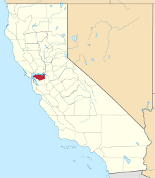
 Sparkle Location in California | |
| Coordinates: 37°55′42″N 122°03′24″W / 37.92833°N 122.05667°WCoordinates: 37°55′42″N 122°03′24″W / 37.92833°N 122.05667°W | |
| Country | United States |
| State | California |
| County | Contra Costa County |
| Elevation[1] | 85 ft (26 m) |
| GNIS ID[1][2] | 1659836 |
| FIPS code[1][2] | 06-73550 |
Sparkle,[1] also known as Sparkel,[3] is an unincorporated community in Contra Costa County, California, United States.[1] It is on the former route of the Sacramento Northern Railroad, now replaced by elevated BART tracks 2 miles (3.2 km)north of downtown Walnut Creek,[3] at an elevation of 85 feet (26 m). It reputedly got its name from a discharge effect on a tight curve of the electrified line of the Sacramento Northern Railroad. It is a county island like nearby Waldon and is surrounded by Walnut Creek and other incorporated cities. The ZIP Code is 94597. The community is inside area code 925.
References
- 1 2 3 4 5 "Sparkle (Contra Costa County, California)". Geographic Names Information System. United States Geological Survey. Retrieved May 10, 2014.
- 1 2 "FIPS55 Data: California". FIPS55 Data. United States Geological Survey. February 23, 2006. Archived from the original on June 18, 2006. Retrieved May 10, 2014. External link in
|work=(help) - 1 2 Durham, David L. (1998). California's Geographic Names: A Gazetteer of Historic and Modern Names of the State. Clovis, Calif.: Word Dancer Press. p. 706. ISBN 1-884995-14-4.
| Bodies of water |
|  |
|---|---|---|
| Counties | ||
| Major cities | ||
| Cities and towns 100k–250k | ||
| Cities and towns 50k–99k | ||
| Cities and towns 25k-50k | ||
| Cities and towns 10k–25k |
| |
| Sub-regions | ||
This article is issued from Wikipedia - version of the 4/2/2016. The text is available under the Creative Commons Attribution/Share Alike but additional terms may apply for the media files.
