Castro Valley, California
| Castro Valley | |
|---|---|
| CDP | |
|
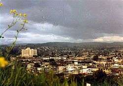
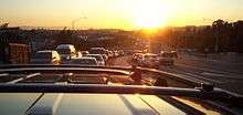
Castro Valley, ca. 1970 | |
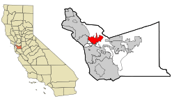 Location of Castro Valley within Alameda County, California. | |
 Castro Valley Location in the United States | |
| Coordinates: 37°41′39″N 122°05′11″W / 37.69417°N 122.08639°WCoordinates: 37°41′39″N 122°05′11″W / 37.69417°N 122.08639°W[1] | |
| Country |
|
| State |
|
| County | Alameda |
| Government | |
| • State Senate | Bob Wieckowski (D)[2] |
| • State Assembly | Bill Quirk (D)[3] |
| • U. S. Congress | Eric Swalwell (D)[4] |
| Area[5] | |
| • Total | 16.919 sq mi (43.819 km2) |
| • Land | 16.635 sq mi (43.083 km2) |
| • Water | 0.284 sq mi (0.735 km2) 1.68% |
| Elevation[6] | 161 ft (49 m) |
| Population (2010) | |
| • Total | 61,388 |
| • Density | 3,690.3/sq mi (1,424.8/km2) |
| Time zone | PST (UTC-8) |
| • Summer (DST) | PDT (UTC-7) |
| ZIP codes | 94546, 94552 |
| Area code(s) | 510 |
| FIPS code | 06-11964 |
| GNIS feature IDs | 1658237, 2407987 |
Castro Valley is a census-designated place (CDP) in Alameda County, California, United States. As of the 2000 census, it is the fifth most populous unincorporated area in California[7] and the twenty-third most populous in the United States. The population was 61,388 at the 2010 census.
Castro Valley is named after Don Guillermo Castro, who was a soldier in the Mexican army and a rancher.
First known for chicken ranches, Castro Valley eventually became a bedroom community.
History
Before the arrival of European settlers the area was settled by the Chocheño (also spelled Chochenyo or Chocenyo) subdivision of the Ohlone Native Americans.
With the arrival of Europeans, Castro Valley was part of the land granted to Mission San Jose in 1797. The area Castro Valley now occupies was part of the extensive colony of New Spain in what was the state of Alta California.
Castro Valley was part of the original 28,000 acre (110 km²) land grant given to Castro, called Rancho San Lorenzo. This land grant included Hayward, San Lorenzo, and Castro Valley, including Crow Canyon, Cull Canyon, and Palomares Canyons. Castro had a gambling habit and had to sell off portions of his land to pay gambling debts. The last of his holding was sold in a sheriff's sale in 1864 to Faxon Atherton for $400,000.[8]
Atherton (after whom the city of Atherton is named[8]) in turn began selling off his portion in smaller parcels. Two gentlemen named Cull (the namesake of Cull Canyon) and Luce bought some 2,400 acres (10 km²) and began running a steam-operated saw mill in Redwood Canyon. The Jensen brothers also bought land from Atherton in 1867.
During the 1940s and 1950s, Castro Valley was known for its chicken ranches. Later it developed into a bedroom community, where workers live and commute to their jobs in the surrounding communities.[9]
Geography
Lake Chabot lies at the north of Castro Valley. Directly to the west is San Leandro. Hayward is to the south. To the east, the closest cities are San Ramon, Dublin, and Pleasanton. The San Leandro Hills extend along the northeastern edge of the community.
The eastern hills of Castro Valley constitute the headwaters of the San Lorenzo Creek watershed and the origin of several creeks that flow into San Lorenzo Creek: Bolinas, Castro Valley, Chabot, Crow, Cull, Eden, Hollis, Kelly Canyon, Norris, and Palomares Creeks.
Demographics
2010
The 2010 United States Census[10] reported that 61,388 people, 22,348 households, and 16,112 families resided in the CDP. The population density was 3,690.3 people per square mile (1,424.8/km²). There were 23,392 housing units at an average density of 1,382.6 per square mile (533.8/km²). The racial makeup of the CDP was 58.0% White (49.5% non-Hispanic), 6.9% African American (6.6% non-Hispanic), 0.5% Native American, 21.4% Asian, 0.7% Pacific Islander, 6.1% from other races, and 6.3% from two or more races. 17.4% of the population was Hispanic or Latino of any race.
The Census reported that 98.0% of the population lived in households, 0.4% lived in non-institutionalized group quarters, and 1.5% were institutionalized.
There were 22,348 households out of which 36.1% had children under the age of 18 living in them, 54.3% were opposite-sex married couples living together, 12.6% had a female householder with no husband present, and 5.2% had a male householder with no wife present. 5.0% of households were unmarried opposite-sex partnerships and 1.0% were same-sex married couples or partnerships. 21.7% of households were made up of individuals and 8.9% had someone living alone who was 65 years of age or older. The average household size was 2.69 and the average family size was 3.15.
The population was spread out with 23.4% under the age of 18, 7.6% aged 18 to 24, 24.5% aged 25 to 44, 31.1% aged 45 to 64, and 13.4% who were 65 years of age or older. The median age was 41.2 years. For every 100 females there were 94.5 males. For every 100 females age 18 and over, there were 91.0 males.
There were 23,392 housing units of which 69.0% were owner-occupied and 31.0% were occupied by renters. The homeowner vacancy rate was 1.3%; the rental vacancy rate was 5.4%. 68.8% of the population lived in owner-occupied housing units and 29.2% lived in rental housing units.
2000
As of the census[11] of 2000, there were 57,292 people, 21,606 households, and 15,016 families residing in the CDP. The population density was 3,971.6 people per square mile (1,533.0/km²). There were 22,003 housing units at an average density of 1,525.3 per square mile (588.7/km²).
There were 21,606 households out of which 32.3% had children under the age of 18 living with them, 54.0% were married couples living together, 11.0% had a female householder with no husband present, and 30.5% were non-families. 23.2% of all households were made up of individuals and 9.3% had someone living alone who was 65 years of age or older. The average household size was 2.58 and the average family size was 3.05.
In the CDP the population was spread out with 23.7% under the age of 18, 6.8% from 18 to 24, 29.8% from 25 to 44, 25.0% from 45 to 64, and 14.7% who were 65 years of age or older. The median age was 39 years. For every 100 females there were 94.6 males. For every 100 females age 18 and over, there were 91.0 males.
The median income for a household in the CDP was $76,197, and the median income for a family was $91,713 as of a 2008 estimate.[12] About 2.7% of families and 4.5% of the population were below the poverty line, including 4.3% of those under age 18 and 4.5% of those age 65 or over.
Economy
The economy of Castro Valley consists largely of the provision of goods and services for local residents. Being a primarily residential community, only about 5% of the area has been developed for commercial uses.[13]
The greatest number of people (6,683) are employed by the health care and social assistance industry, followed by the retail trade industry with 1,073 employees and accommodation and food service with 1,044 employees.[14] The health care and social assistance industry provided $1.1 billion in sales, shipments, receipts or revenue in 2012, which is the highest of all industries, and it is followed by the retail trade industry, which had a value of $324.1 million in sales, shipments, receipts or revenue.[14]
The median household income of residents was $83,211 in 2013,[15] compared to a median income of $72,112 for all of Alameda County.[16]
Art and culture
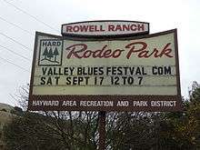
Castro Valley is one of the sites where Joseph Eichler built some of the 10,000 or so homes he built in the Bay Area.[17] Castro Valley has a one-screen movie theater, the Chabot Cinema. The Castro Village complex on Castro Valley Boulevard is widely considered the commercial center of town.[18] The Harry Rowell Rodeo Ranch is located in Castro Valley and is managed by the Hayward Area Recreation and Park District. Rodeos are held there regularly.[19]
Historical landmarks & museums
| Site of the first public school in Castro Valley | |
|---|---|
| Location | 19200 Redwood Rd., Castro Valley, California |
| Coordinates | 37°42′24″N 122°04′26″W / 37.7067°N 122.073983°W |
| Reference no. | 776[20] |
First public school in Castro Valley
The first public school in Castro Valley is a designated California Historical Landmark. A plaque is placed at the original site. The one-room schoolhouse was donated for "educational purposes only," by Josiah Grover Brickell in 1866. Brickell provided the salary for the first teacher. During the day the teacher taught children and in the evening they taught farmhands.[20] The school burnt down in 1901. It was rebuilt and burned down again in 1920. A new school was built on another property.[21]
Adobe Art Gallery
The Adobe Art Gallery is a program operated by the Hayward Area Recreation and Park District promoting the visual arts and uses the Adobe building, built as a Works Progress Administration project in 1936.[22]
Law and government
Castro Valley is an unincorporated community and thus is governed directly by the County of Alameda. There is no city police force, with policing provided by the Alameda County Sheriff's Office and the California Highway Patrol. The town has fire protection provided by the Alameda County Fire Department. Castro Valley has its own sanitary district,[23] as well as its own school district.[24] Efforts to incorporate Castro Valley have been voted down by its residents at the polls in both 1956 and 2002.[9][25] Castro Valley is also represented by a seven-member Municipal Advisory Council, which is an advisory body appointed to advise the Alameda County Board of Supervisors on local issues.[26]
Education
As of 2013, educational attainment for Castro Valley residents 25 to 34 years old is 95.4% have a high school degree or higher and 42.8% have a bachelor's degree or higher.[27]
Public schools
Castro Valley is primarily served by the Castro Valley Unified School District, though portions of it are served by the Hayward Unified School District (South of I-580 and West of Grove Way) and the San Lorenzo Unified School District (westernmost part). Overall, the Castro Valley Unified School District serves almost 9,000 students.[28]
The main high school is Castro Valley High School with over 3000 students.[29] Castro Valley also has Redwood High School, an alternative high school with approximately 193 students in 2005.[30]
- Castro Valley has two public middle schools: Canyon Middle School and Creekside Middle School.
- Castro Valley has nine public elementary schools: Castro Valley, Chabot, Independent, Jensen Ranch, Marshall, Palomares, Proctor, Stanton, and Vannoy.
The school district includes the Castro Valley Adult School.
Private schools
There is also a Roman Catholic school, called Our Lady of Grace (K-8), which is part of the Roman Catholic Diocese of Oakland. Redwood Christian Schools has one elementary school (K-5) Redwood Christian Elementary.[31]
Transportation
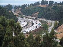
Interstate 580, which approaches from the east, makes a turn northward at Castro Valley. Interstate 238, which originates in Castro Valley, connects I-580 to Interstate 880. In addition to being served by those two freeways, Castro Valley is served with public transportation by bus system AC Transit, and rapid transit system BART with a station.
The primary local east-west arterial road is Castro Valley Boulevard, while Lake Chabot Road, Redwood Road and Crow Canyon Road are the major north-south arterials.[32]
Historically, Castro Valley Boulevard was part of the first transcontinental highway system, the Lincoln Highway.[33]

Services
Eden Medical Center operates in Castro Valley. It is a Sutter Health facility, and provides basic emergency medical services for the area.[34]
Notable residents
- Christopher Andersen, journalist, former editor of Time and People magazines, No. 1 New York Times bestselling author
- Amy Berg, television writer and producer[35]
- Amy Caron, professional female Skateboarder.[36]
- David Bingham, soccer player[37]
- Mike Bordin, co-founder and drummer of Faith No More, as well as drummer for Black Sabbath, Korn and Ozzy Osbourne, attended Castro Valley High School [38]
- Brodie Brazil, Emmy award winning reporter for Comcast SportsNet Bay Area/Comcast SportsNet California and San Jose Sharks sideline reporter[39]
- Cliff Burton (deceased), former bassist of Metallica, attended Castro Valley High School[40]
- Darren Brazil, Editor for Comcast SportsNet Bay Area[41]
- Jason Castro (baseball), Major League Baseball player, born in Castro Valley[42]
- Frank Cepollina, engineer
- Tim Davis, football coach[43]
- Jack Del Rio, head coach of the Oakland Raiders.[44]
- Val Diamond of Beach Blanket Babylon[45]
- Garret Dillahunt, actor, No Country For Old Men, born in Castro Valley[46]
- Craig Ferguson, Canadian ice hockey player[47]
- Kyle Gass, musician, actor
- Tony Gemignani, world champion pizza tosser, owner of Pyzano's Pizza in Castro Valley.[48]
- Adam Heether, Minor League Baseball player[49]
- Sebastian Janikowski, Polish Football player for the Oakland Raiders, current resident[50]
- Brian Keyser, Major League Baseball player[51]
- Kris LaPoint, professional water skier[52]
- Jennifer Lin, 1994 murder victim while a student at Canyon Middle School[53]
- Luenell, actress and comedian[54]
- Kevin Maas, Major League Baseball player[55]
- Rachel Maddow, anchor and political analyst on MSNBC's The Rachel Maddow Show and The Rachel Maddow Show on Air America Radio.[56]
- "Big" Jim Martin, former guitar player for Faith No More[57]
- Richard McCroskey (1988–), convicted mass murderer in the Farmville murders[58]
- Psyclon Nine, aggrotech and industrial metal group
- Daniel Selby, actor and public speaker[59]
- Ed Sprague, Jr., Major League Baseball player[60]
- Jim and Jennifer Stolpa, whose story was featured in the film Snowbound: The Jim and Jennifer Stolpa Story[43]
- Greg Tabor, Major League Baseball player[61]
- Christopher Titus, comedian[62]
- Casey Wellman, professional ice hockey player[63]
References
- ↑ "US Gazetteer files: 2010, 2000, and 1990". United States Census Bureau. 12 February 2011. Retrieved 23 April 2011.
- ↑ "Senators". State of California. Retrieved 18 March 2013.
- ↑ "Members Assembly". State of California. Retrieved 18 March 2013.
- ↑ "California's 15th Congressional District - Representatives & District Map". Civic Impulse, LLC. Retrieved 14 March 2013.
- ↑ "U.S. Census". Archived from the original on 14 July 2012. Retrieved 15 September 2012.
- ↑ "Castro Valley". Geographic Names Information System. United States Geological Survey.
- ↑ List of largest census-designated places in California
- 1 2 Gudde, Erwin Gustav. "California Place Names: The Origin and Etymology of Current Geographical Names" University of California Press 2004. 495 pp.
- 1 2 Lorge, L, Phelps, R, Weston, D. "Castro Valley" Arcadia Publishing, 2005. 128 pp.
- ↑ "2010 Census Interactive Population Search: CA - Castro Valley CDP". U.S. Census Bureau. Retrieved 12 July 2014.
- ↑ "American FactFinder". United States Census Bureau. Archived from the original on 11 September 2013. Retrieved 31 January 2008.
- ↑ "American FactFinder". Factfinder.census.gov. Retrieved 15 September 2012.
- ↑ "Ch. 4". Castro Valley General Plan 2012 (PDF).
- 1 2 "Castro Valley, CDP. U.S. Census Bureau, 2012 Economic Census, 2012 Economic Census of Island Areas, and 2012 Nonemployer Statistics.".
- ↑ "Castro Valley, CDP. U.S. Census Bureau, 2009-2013 5-Year American Community Survey".
- ↑ "Alameda County, CA. U.S. Census Bureau, 2009-2013 5-Year American Community Survey".
- ↑ Jones, Carolyn (8 June 2000). "Vanishing Eichlers / Devotees try to curb loss of 1950s-era modernist tract homes". San Francisco Chronicle. Hearst Communications Inc. Retrieved 22 February 2010.
- ↑ "Castro Village Shopping Center". Castrovillage.com. Retrieved 15 September 2012.
- ↑ "index". Rowellranchrodeo.com. Retrieved 15 September 2012.
- 1 2 "Site of the first public school in Castro Valley". Office of Historic Preservation, California State Parks. Retrieved 5 October 2012.
- ↑ Christian, John. "Other Early Castro Valley Schools (That Weren't Borrowed, Stolen, Or Made to Disappear)". Local Voices. Hayward Area Historical Society. Retrieved 31 August 2012.
- ↑ "Adobe Art Gallery". Retrieved 9 August 2015.
- ↑ "Castro Valley Sanitary District - Effective environmental services since 1939". cvsan.org. Retrieved 14 January 2016.
- ↑ "Welcome to CVUSD — Castro Valley Unified". cv.k12.ca.us. Retrieved 14 January 2016.
- ↑ Holzmeister, Karen. "C.V. had city plans way back in 1949; Incorporation last". The Daily Review (Hayward, CA).
- ↑ "Castro Valley MAC". Castro Valley MAC.
- ↑ "2009-2013 5-Year American Community Survey". U.S. Census Bureau.
- ↑ "Our Schools — Castro Valley Unified School District". Retrieved 2 September 2008.
- ↑ "2007-2008 School Profile - Castro Valley High School" (PDF). Retrieved 2 September 2008.
- ↑ "Redwood Alternative High School/Redwood Continuation High School". Archived from the original on 2 March 2008. Retrieved 2 September 2008.
- ↑ "Redwood Christian Schools". Redwood Christian Schools. 2008. Retrieved 19 November 2008.
- ↑ "Ch. 6". Castro Valley General Plan (PDF).
- ↑ "Map of the Lincoln Highway". Retrieved August 2015. Check date values in:
|access-date=(help) - ↑ "Eden Medical Center". edenmedicalcenter.org. Retrieved 14 January 2016.
- ↑
- ↑ http://espn.go.com/action/athlete/_/id/24880/amy-caron
- ↑ Archived 5 September 2011 at the Wayback Machine.
- ↑ "MusicMight :: Artists :: EZ-STREET". rockdetector.com. Retrieved 14 January 2016.
- ↑ "SportsNet Central Bios | CSNBayArea.com | CSNCalifornia.com". CSNBayArea.com. 10 September 2012. Retrieved 15 September 2012.
- ↑ Ganahl, Jane (30 August 1998). "MODERN MATURITY: Metallica drummer Lars Ulrich on how his band has survived the tests of time and the rock life". San Francisco Examiner. Hearst Communications, Inc. Retrieved 16 November 2008.
- ↑ Darren Brazil
- ↑ Simmons, Rusty (30 March 2005). "It's easy to see that catchers are rising stars / Six rated among nation's top 40". The San Francisco Chronicle.
- 1 2 []
- ↑ "Jaguars sack Jack Del Rio, will sell team". Espn.go.com. 30 November 2011. Retrieved 15 September 2012.
- ↑ Klatte, Arline. "Profile: Val Diamond". E-Guide Entertainment on the Gate. Hearst Communications Inc. Archived from the original on 4 July 2008. Retrieved 11 August 2008.
- ↑ "Garret Dillahunt". IMDb. Retrieved 14 January 2016.
- ↑ "Craig Ferguson (b. 1970) hockey statistics and profile at". Hockeydb.com. 8 April 1970. Retrieved 15 September 2012.
- ↑ Bauer, Michael (25 June 2008). "Pizza of the Week: Pyzano's in Castro Valley". San Francisco Chronicle. Hearst Communications, Inc. pp. F–2. Retrieved 16 November 2008.
- ↑ "Adam Heether Stats, Bio, Photos, Highlights | MiLB.com Stats | The Official Site of Minor League Baseball". Louisville.bats.milb.com. 14 January 1982. Retrieved 15 September 2012.
- ↑ "Raiders' kicker pleads innocent to DUI charges. Category: Page One from". The Berkeley Daily Planet. Retrieved 15 September 2012.
- ↑ "Brian Keyser Baseball Stats by Baseball Almanac". Baseball-almanac.com. Retrieved 15 September 2012.
- ↑ "Galleries". CNN. 3 August 1970.
- ↑ "Lin Murder Suspect, Long Time Focus", ABC7, 2006
- ↑ "Q&A with Borat star Luenell, headlining at Tommy T's this weekend - Pete's Popcorn Picks - November 2008 - contra costa". Diablomag.com. 28 November 2008. Retrieved 15 September 2012.
- ↑ Mccarron, Anthony (4 October 2008). "Where are they now? Former Yankee Kevin Maas is a solid investment". Daily News. New York.
- ↑ Garofoli, Joe (5 September 2008). "Rachel Maddow Talks to Us on GOP Culture War (Podcast)". SFGATE.com. Hearst Communications, Inc. Retrieved 16 November 2008.
- ↑ Chirazi, Steffan (5 October 1997). "LOSING THE FAITH RENEWS MARTIN'S HOPE". San Francisco Chronicle. Hearst Communications, Inc. pp. PK–55. Retrieved 16 November 2008.
- ↑ Bulwa, Demian (22 September 2009). "Bay Area suspect allegedly bludgeoned victims". The San Francisco Chronicle.
- ↑ "Daniel Selby". IMDb. Retrieved 14 January 2016.
- ↑ "Ed Sprague Baseball Stats by Baseball Almanac". Baseball-almanac.com. Retrieved 15 September 2012.
- ↑ "Greg Tabor Baseball Stats by Baseball Almanac". Baseball-almanac.com. Retrieved 15 September 2012.
- ↑ "Christopher Titus". IMDb. Retrieved 14 January 2016.
- ↑ "Casey Wellman Stats, News, Videos, Highlights, Pictures, Bio - Florida Panthers - ESPN". Espn.go.com. 18 October 1987. Retrieved 15 September 2012.
External links
| Wikimedia Commons has media related to Castro Valley, California. |
- "Castro Valley". Geographic Names Information System. United States Geological Survey.
- Castro Valley Chamber of Commerce
- Castro Valley News - Local News and Information
- Castro Valley Matters - Local Advocacy Group
- Castro Valley history
- Castro Valley Unified School District
- Friends of San Lorenzo Creek
| Bodies of water |
|  |
|---|---|---|
| Counties | ||
| Major cities | ||
| Cities and towns 100k–250k | ||
| Cities and towns 50k–99k | ||
| Cities and towns 25k-50k | ||
| Cities and towns 10k–25k |
| |
| Sub-regions | ||
Municipalities and communities of Alameda County, California, United States | ||
|---|---|---|
| Cities | 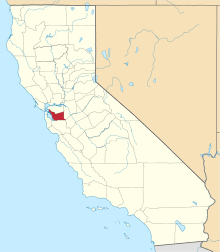 | |
| CDPs | ||
| Unincorporated communities | ||
| Former settlements | ||