Kırklareli Province
| Kırklareli Province Kırklareli ili | |
|---|---|
| Province of Turkey | |
 Location of Kırklareli Province in Turkey | |
| Country | Turkey |
| Region | West Marmara |
| Subregion | Tekirdağ |
| Government | |
| • Electoral district | Kırklareli |
| • Governor | Ali Haydar Öner |
| Area | |
| • Total | 6,550 km2 (2,530 sq mi) |
| Population (2010-12-31)[1] | |
| • Total | 332,791 |
| • Density | 51/km2 (130/sq mi) |
| Area code(s) | 0288O |
| Vehicle registration | 39 |
| Website | http://www.kirklareli.gov.tr/ |
Kırklareli Province (Turkish: Kırklareli ili) is a province in northwestern Turkey on the west coast of the Black Sea. The province neighbours Bulgaria to the north along a 180-kilometre (110 mi) long border. It borders the province of Edirne to the west and the province of Tekirdağ to the south and province of Istanbul to the southeast. Kırklareli is the capital city of the province. The province's and its central city's name means "the land of the forties" in Turkish and it may refer either to the forty Ottoman ghazis sent by the sultan Murad I to conquer the city for the Ottoman Empire in the 15th century or to the forty churches reported to be situated in the region before the Ottoman conquest, as attested by the former name of Kırklareli (Kırk Kilise in Turkish; Σαράντα Εκκλησιές, Saranta Eklesies in Greek). There is a memorial on a hilltop in Kırklareli city, called "Kırklar Anıtı" (the Memorial of the Forties in Turkish) to honor the Ottoman conquerors (For more on the name's origins, see Kırklareli).
The province is bisected by the Yıldız (Istranca) mountain range. The north and northeastern parts of the province are among the least populated and under developed parts of Turkey. The districts to the south and west are more populated because the land is better suited for agriculture and industrial development. The north and eastern parts of the province are dominated by forests. Therefore, forestry is an important means of living in these areas. Fishing is done along the Black Sea coast.
Agriculture

The province of Kırklareli is an important region for viticulture and winemaking. A syrup called "Hardaliye", made of grape, cherry leaves and mustard seeds, is a non-alcoholic beverage special to the region.[2][3]
Local attractions
Dupnisa Cave is a famous natural attraction and a unique geological formation within the borders of the province in the north. The 60 km long coast along the Black Sea harbors one of the most pristine and undeveloped beaches in all of Turkey. There are two Nature Reserve Areas along the coast namely Saka Gölü (Saka Lake) Nature Reserve Area to the north and Kasatura Körfezi (Kasatura Bay) Nature Reserve Area to the south. These sites are unique with their undisturbed ecosystems harboring several endangered and endemic plant and animal species.
Districts
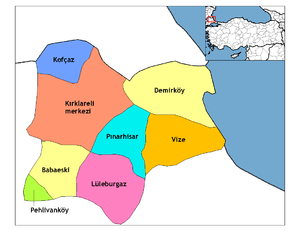
Kırklareli province is divided into eight districts (capital district in bold):
Sister cities
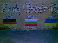
Kırklareli is twinned with:
See also
References
- ↑ Turkish Statistical Institute, MS Excel document – Population of province/district centers and towns/villages and population growth rate by provinces
- ↑ "Trakya'daki il, ilçe ve beldelerimizi tanıyalım...". Matmara Haber (in Turkish). 2015-03-13. Retrieved 2015-07-28.
- ↑ "Hardaliye Üretimin Mevcut Durumunu Değerlendirme Raporu" (PDF) (in Turkish). Trakya Kalkınma Ajansı - Kırklareli Yatırım Destek Ofisi. December 2014. Retrieved 2015-07-28.
External links
- Kırklareli Weather Forecast Information
- Forum of Kırklareli University
- Kırklareli News
- Kırklareli Photos
| ||
Metropolitan municipalities are bolded. | ||
Coordinates: 41°40′52″N 27°28′17″E / 41.68111°N 27.47139°E