Yozgat Province
| Yozgat Province Yozgat ili | |
|---|---|
| Province of Turkey | |
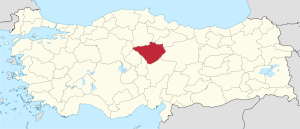 Location of Yozgat Province in Turkey | |
| Country | Turkey |
| Region | Central Anatolia |
| Subregion | Kayseri |
| Government | |
| • Electoral district | Yozgat |
| Area | |
| • Total | 14,123 km2 (5,453 sq mi) |
| Population (2010-12-31)[1] | |
| • Total | 476,096 |
| • Density | 34/km2 (87/sq mi) |
| Area code(s) | 0354 |
| Vehicle registration | 66 |
Yozgat Province (Turkish: Yozgat ili) is a province in central Turkey. Its adjacent provinces are Çorum to the northwest, Kırıkkale to the west, Kırşehir to the southwest, Nevşehir to the south, Kayseri to the southeast, Sivas to the east, Tokat to the northeast, and Amasya to the north. The provincial capital is Yozgat.
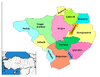
Districts
Yozgat province is divided into 14 districts (capital district in bold):
- Akdağmadeni
- Aydıncık
- Boğazlıyan
- Çandır
- Çayıralan
- Çekerek
- Kadışehri
- Saraykent
- Sarıkaya
- Şefaatli
- Sorgun
- Yenifakılı
- Yerköy
- Yozgat
Etymology
City's original name "Bozok" and,later The name was changed to Yozgat province. Oguz, "Bozok" arm belonging to flock to this area with the Turkmen,region "Bozok" was referred to by name. Towards the 1800s as well as the name "Yozgat" name was pronounced.
"Yozgat" about the origin of the name, the different rumors are put forward.According to a rumor,Yozgat layers are rising from the bottom up Saray from town. This is because many times the height of the rise and altitude at first "hundred times" was called. time grumbling under the name "Yozgat" has become.
History
Yozgat, presumably has a history of 5000 years. Yozgat around the state established the first political union is the Hittites. Hittite era, today Yozgat is located within the boundaries established in the ancient city of Hattusa.
Geography
Yozgat is located on the Plateau of Bozok in the Department of the Central Red River in the Central Anatolia Region. Samsun-Ankara-Sivas highway and Kayseri and Mersin highways pass through Yozgat. From our country and from Europe to the Middle East trade further increases the importance of this pathway. Projected area 13,597 km ², while the actual area 14,123 km ². More mountainous province in general is not.
Education
In the province, there are Bozok University offering bachelor's degree. In addition to this, There are Anatolian Teacher High School, Tourism and Hospitality Management and Anatolian high schools, Science High School and Yozgat Vocational High School in the province of Yozgat.
Economy
In Yozgat-intensive production are food processing, clothing, metal processing, bricks and ready-mixed concrete production.
- Agriculture
City's economy is largely based on agriculture. Heavily in the province, grains and legumes are grown. As well as their, sugar beet, sunflower, potato and onion-type products are grown in irrigated agricultural areas. Kadışehr district in fruit production between regions is expected to make great strides. Deveci Basin is an ideal area for apple production.
See also
References
- ↑ Turkish Statistical Institute, MS Excel document – Population of province/district centers and towns/villages and population growth rate by provinces
External links
![]() Media related to Yozgat Province at Wikimedia Commons
Media related to Yozgat Province at Wikimedia Commons
- (Turkish) Yozgat official website
- (Turkish) Yozgat governor's official website
- (Turkish) Yozgat municipality's official website
- (English) Yozgat weather forecast information
Coordinates: 39°40′10″N 35°16′09″E / 39.66944°N 35.26917°E
| ||
Metropolitan municipalities are bolded. | ||