2008–09 South Pacific cyclone season
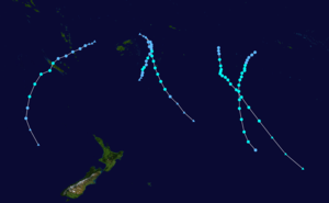 | |
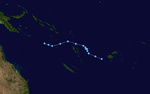
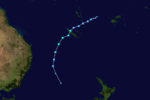
| Season summary map | |
| First system formed | December 1, 2008 |
|---|---|
| Last system dissipated | April 11, 2009 |
| Strongest storm1 | Lin – 975 hPa (mbar), 110 km/h (70 mph) (10-minute sustained) |
| Total disturbances | 15 |
| Total depressions | 12 |
| Tropical cyclones | 6 |
| Severe tropical cyclones | 0 (Record low) |
| Total fatalities | 11 |
| Total damage | $65 million (2009 USD) |
| 1Strongest storm is determined by lowest pressure | |
2006–07, 2007–08, 2008–09, 2009–10, 2010–11 | |
| Related articles | |
The 2008–09 South Pacific cyclone season began on December 1, 2008 with the formation of Tropical Disturbance 01F. This was 30 days after the season had officially begun on November 1, 2008.[1] The season officially ended on April 30, 2009. Tropical cyclones that were between 160°E and 120°W and north of 25°S were monitored by the Fiji Meteorological Service. Those that moved south of 25°S were monitored by the Tropical Cyclone Warning Centre (TCWC) in Wellington, New Zealand.[1]
During the season, there were 15 Tropical Disturbances with 12 of them intensifying into Tropical Depressions, which were monitored by the Regional Specialized Meteorological Centre in Nadi, Fiji, which is a part of the Fiji Meteorological Service. Only five of the Tropical Depressions intensified into Tropical Cyclones which were named Hettie, Innis, Joni, Ken, and Lin. Both Cyclone Innis and Cyclone Hettie had peak wind speeds of 75 km/h (45 mph) which made them Category One cyclones on the Australian Tropical Cyclone Intensity Scale, whilst Cyclone Ken had wind speeds of 95 km/h (60 mph). Cyclones Joni and Lin had peak wind speeds of 100 km/h (65 mph) and 110 km/h, (70 mph) respectively which made them Category 2 cyclones. Cyclone Jasper also moved into the region from the Australian basin at its peak wind speeds of 100 km/h (65 mph) which made it a Category Two cyclone. For the first time since the 1994-95 tropical cyclone season there were no tropical cyclones that developed into a Severe Tropical Cyclone, which have winds of at least 120 km/h (75 mph).
Seasonal forecasts
| Source Record | Tropical Cyclone | Severe Tropical Cyclone | Ref |
|---|---|---|---|
| Record high: | 1997–98:16 | 1982–83:10 | |
| Record low: | 2003–04: 3 | 1994-95:1 | |
| NIWA | 8–10 | - | |
| FMS | 9 | 4.5 | |
| Actual activity | 7 | 0 | |
| References:[2][3][4] | |||
During September and October 2008, both RSMC Nadi and New Zealand's National Institute of Water and Atmospheric Research (NIWA) issued seasonal forecasts which contained information on how many tropical cyclones that were predicted to develop within the upcoming season. Both agencies expected that the season would see a near average amount of tropical cyclone activity within the South Pacific basin as ENSO neutral conditions were predicted to last throughout the season. As a result of these conditions, RSMC Nadi and NIWA both predicted that 5–8 tropical cyclones would exist within the basin.
Season summary
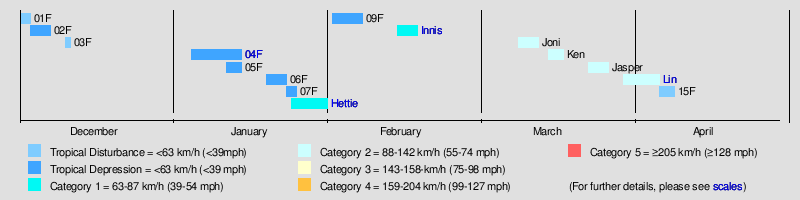
During the 2008–09 season, fifteen Tropical disturbances passed through RSMC Nadi's area of responsibility. Of these fifteen disturbances only eleven developed into Tropical Depressions, with a further five becoming Tropical cyclones within RSMC Nadi's area of responsibility with a further three cyclones forming within the Coral sea. No Tropical Cyclone intensified into a Severe Tropical cyclones this season to the east of 160E, with only Cyclone Hamish intensifying into one to the west of 160E.
Notable Tropical depressions include Tropical Depression 04F, which caused Fiji's second worst natural disasters. Tropical Depression 08F, which intensified into Cyclone Hettie becoming the first tropical cyclone to form this season. Tropical Depression 10F brought heavy rains to Vanuatu and before making landfall on New Caledonia intensified into Category One Tropical Cyclone Innis. After it made landfall Innis became the first Tropical Depression to move into TCWC Brisbane's Area of responsibility since Cyclone Larry. Cyclones Joni and Ken both threatened the Southern Cook Islands however the only impact they had was minimal. Cyclone Jasper then moved into the region early on March 24 at peak intensity, having developed inside TCWC Brisbane's area of responsibility two days earlier. The final Tropical Depression this year to develop was Tropical Cyclone Lin near to the Lau Group of Fiji and Tonga.
Storms
Tropical Depression 02F
| Tropical depression (Australian scale) | |||
|---|---|---|---|
| |||
| Duration | December 3 – December 6 | ||
| Peak intensity | 45 km/h (30 mph) (10-min) 1004 hPa (mbar) | ||


Early on December 3, RSMC Nadi reported that a Tropical Disturbance had formed near the Southern Cook Islands and was located in a moderately sheared environment and was moving towards the southeast.[5][6] Deep Convection had been present around a well-defined cyclonic circulation for the previous 24 hours.[6] Over the next day the disturbance gradually developed with RSMC Nadi upgrading it to a Tropical Depression later that day whilst it was moving between Niue and the Southern Cook Islands.[7] Over the next couple of days the depression gradually weakened with convection which was located in the southern and eastern quadrants became sheared and the low level circulation centre became exposed as it moved into an area of cooler sea surface temperatures.[8] Late on December 6 RSMC Nadi issued their final advisory on the depression as it moved into TCWC Wellingtons area of responsibility and was expected to become a mid latituted low pressure system within 12 hours.[9]
Tropical Disturbance 03F
| Tropical disturbance (Australian scale) | |||
|---|---|---|---|
| |||
| Duration | December 10 – December 11 | ||
| Peak intensity | 35 km/h (25 mph) (10-min) 1001 hPa (mbar) | ||

Late on December 10, RSMC Nadi reported that a Tropical disturbance had formed near to the western edge of their area of responsibility.[10] The disturbance had no definite low level circulation center with convection confined to the north quadrant of the disturbance.[10] The disturbance lied to the west of an upperlevel anticyclone and was located in an area of moderately sheared environment.[10] Early the next day, RSMC Nadi issued their final advisory on the disturbance as it was difficult to locate the low level circulation center as there seemed to be a more dominant cyclonic circulation to the northwest of 03F which they reported might have engulfed the system.[11]
Tropical Depression 04F
| Tropical depression (Australian scale) | |||
|---|---|---|---|
| |||
| Duration | January 4 – January 12 | ||
| Peak intensity | 65 km/h (40 mph) (10-min) 994 hPa (mbar) | ||


Tropical Depression 04F formed late on January 4, as a weak tropical disturbance near to the eastern edge of RSMC Nadi's responsibility.[12] The disturbance then rapidly organised itself sufficiently to be classified as Tropical Depression 04F early the next morning.[13] Over the next couple of days the depression moved towards the southeast, before on January 8 as it started to bring heavy rainfall to Fiji.[14] RSMC Nadi then issued their final advisory on it later that day, as it was now an extratropical depression. However late the next day RSMC Nadi started to reissue advisories on the depression and immediately passed primary warning responsibility for it to the Tropical Cyclone Warning Center in Wellington, who issued warnings on the depression until early on January 12 when they issued their last advisory.
Floods and mudslides caused by the depression killed at least eleven people in Fiji. Several towns and rural areas on Viti Levu were flooded.[15]
Tropical Depression 05F
| Tropical depression (Australian scale) | |||
|---|---|---|---|
| |||
| Duration | January 11 – January 14 | ||
| Peak intensity | 55 km/h (35 mph) (10-min) 999 hPa (mbar) | ||
On January 11, RSMC Nadi reported that a tropical depression had formed to the south of the Solomon Islands and was just inside TCWC Brisbane's area of responsibility, and started issuing Tropical Disturbance Summaries on it. As the depression moved into RSMC Nadi’s area of responsibility it was designated as 05F. Nadi reported at this time that whilst the depression had a low to moderate chance of forming into a tropical cyclone within 48 hours, there was an upper trough of low pressure that could provide an opportunity for the depression to either rapidly or explosively develop. Despite fair conditions, it dissipated without ever becoming a cyclone.
Tropical Depression 06F
| Tropical depression (Australian scale) | |||
|---|---|---|---|
| |||
| Duration | January 19 – January 23 | ||
| Peak intensity | 55 km/h (35 mph) (10-min) 1005 hPa (mbar) | ||


Late on January 19, RSMC Nadi reported that a tropical disturbance had formed in a monsoonal trough of low pressure about 940 km to the north west of Papeete, in French Polynesia. Convection was confined to the northeast of the low level circulation and was disorganised.[16][17][18] Late the next day whilst the disturbance was moving to the east and into an area of higher vertical wind shear, RSMC Nadi upgraded the disturbance to a tropical depression despite its low level circulation centre being exposed and lying to the west of the deep convection.[18] During the next morning as it interacted with another disturbance to the northwest the depression reached its peak wind speeds of 55 km/h, (35 mph)[19][20] Over the next couple of days th depression moved towards the south before late on January 23 RSMC Nadi issued their final advisory on the depression as it was expected to become a hybird system within 24 hours.[21]
Tropical Depression 07F
| Tropical depression (Australian scale) | |||
|---|---|---|---|
| |||
| Duration | January 23 – January 25 | ||
| Peak intensity | 65 km/h (40 mph) (10-min) 1006 hPa (mbar) | ||


On January 23, RSMC Nadi reported that a Tropical Depression had formed, to the southwest of American Samoa. Later that day as the Depression moved towards the east they downgraded the Depression to a Tropical Disturbance as the Low Level Circulation Center was exposed and located in an environment of moderate to strong vertical wind shear.[22] During the morning of January 24 the Tropical Disturbance was reupgraded to a Tropical Depression and assigned the Tropical Depression the designation of 07F.[23] Later that day the tropical depression reached its peak wind speeds of 65 km/h (40 mph).[24] Early the next day RSMC Nadi released their final Tropical Disturbance Summary as the Tropical Depression had lost all tropical characteristics.[25]
Tropical Cyclone Hettie
| Category 1 tropical cyclone (Australian scale) | |||
|---|---|---|---|
| Tropical storm (SSHWS) | |||
| |||
| Duration | January 24 – January 31 | ||
| Peak intensity | 65 km/h (40 mph) (10-min) 995 hPa (mbar) | ||


On January 24, RSMC Nadi reported that Tropical Disturbance 08F had developed within the monsoon trough and an area of minimal vertical windshear to the north of the Fijian dependency Rotuma.[26] During the next day the disturbance moved towards the southeast and developed into a tropical depression while it was located near Rotuma.[26] Over the next 3 days, the depression continued to move south-eastwards between Fiji and Tonga while intensifying slowly against stronger vertical windshear. before RSMC Nadi and the JTWC reported that the depression had developed into a tropical cyclone during January 28.
Cyclone Hettie did not directly affect any inhabited land areas.[26]
Tropical Depression 09F
| Tropical depression (Australian scale) | |||
|---|---|---|---|
| |||
| Duration | February 1 – February 5 | ||
| Peak intensity | 55 km/h (35 mph) (10-min) 998 hPa (mbar) | ||
On February 1, RSMC Nadi reported that Tropical Depression 09F had developed within the monsoon trough about 575 km (355 mi) to the northeast of Port Vila, Vanautu.
Late on February 1, a Tropical disturbance formed about 645 km (401 mi) to the west of Vanuatu and was embedded in a monsoonal trough. It quickly organized itself and thus later that day, it was upgraded to Tropical Depression 09F. At this time the Low Level Circulation Center was exposed as strong vertical wind shear and deep convection was displaced to the north of Low Level Circulation Center. The next morning the JTWC reported that deep convection, was located over the western boundary, of the depression's low level circulation center. Strong shear also still existed over the system, with deep convection still being displaced to the north of the system. The next morning RSMC Nadi reported that the Low Level Circulation Center was obscured with indications of good inflow bands flowing into the depression from the north and west.
Early on February 5, RSMC Nadi issued its final advisory on the depression, as the systems low level circulation centre had become sheared and exposed.[27]
Tropical Cyclone Innis
| Category 1 tropical cyclone (Australian scale) | |||
|---|---|---|---|
| Tropical storm (SSHWS) | |||
| |||
| Duration | February 13 – February 18 | ||
| Peak intensity | 75 km/h (45 mph) (10-min) 990 hPa (mbar) | ||
On February 13, RSMC Nadi reported that Tropical Depression 10F had developed within an active convergence zone, about halfway between Fiji and Vanuatu.[26][28] Over the next 2 days the system gradually developed further as it moved westwards, before it passed over Vanautu during February 15, with hostile environmental conditions influencing the systems chances of becoming a tropical cyclone.[26] As it left Vanuatu the system turned towards the southwest and started to move towards New Caledonia as outflow over the depression developed while bands of convection began to wrap around the centre.[26][29] During February 16, as the system approached New Caledonia, RSMC Nadi noted that future prospects of the system becoming a tropical cyclone were being undermined by increasing vertical windshear and land interaction.[26] As a result of this RSMC Nadi subsequently issued their final warning on the system, however early the next day RSMC Nadi started to reissue warnings after the system had crossed New Caledonia and moved into an area of low vertical windshear.[26][30][31] Later that day as the system became a category one tropical cyclone on the Australian tropical cyclone intensity scale, RSMC Nadi named it Innis, while the JTWC initiated advisories on the system and designated it as Tropical Cyclone 15P.[32]
After a brief period of further development, both the JTWC and RSMC Nadi reported that Innis had peaked with sustained windspeeds of 75 km/h (45 mph) before vertical windshear over the system increased as an upper level low encroached on Innis from the west.[28][33][34] Later that day the primary responsibility for warnings was passed to TCWC Wellington, as the exposed low level circulation centre moved below 25°S and into their area of responsibility.[26][35] Innis was subsequently declared an extratropical cyclone early on February 18, as it briefly moved into the Australian region and TCWC Wellington issued their first warning.[26][36] The system was subsequently absorbed by a low that was moving between Australia and New Zealand, and had caused flooding within the Australian state of New South Wales.[37][38] There was no significant damage reported within New Caledonia, after Innis had affected the island and dropped over 100 mm (3.9 in) of rainfall.[39] Between February 19–20, the low containing Innis remnants brought high winds, heavy rain and some minor flooding to several parts off New Zealand including from Auckland to Stewart Island.[40] The heaviest rain was recorded in Taranaki, Canterbury and Otago, while 1 indirect death was reported after a car rolled over near Opotiki.[40]
Tropical Cyclone Joni
| Category 2 tropical cyclone (Australian scale) | |||
|---|---|---|---|
| Tropical storm (SSHWS) | |||
| |||
| Duration | March 10 – March 14 | ||
| Peak intensity | 100 km/h (65 mph) (10-min) 980 hPa (mbar) | ||


On March 10, RSMC Nadi reported that Tropical Depression 11F had developed out of an area of low pressure that had spun down from the upper levels of the troposphere, about 380 km (235 mi) to the northeast of Rarotonga in the Southern Cook Islands.[26][41] During the next day, shear decreased sufficiently to allow significant overall development. On the evening of the 11th, with the system moving into minimal shear, and outflow aloft becoming well-established, its probability of becoming a tropical cyclone in the next 12 hours was raised to high. At 111200 UTC, it was named Joni with 35 knots close to the centre and whilst located about 40 nautical miles west-northwest of Mangaia and about 70 miles east-southeast of Rarotonga. With favourable conditions, the cyclone continued to intensify and attained storm intensity 18 hours later. Joni reached peak intensity as it neared 25 South latitude, the Nadi and Wellington border. Wellington accepted primary responsibility for further warnings beginning at 130000 UTC as the cyclone moved into their area of responsibility. Joni remained a cyclone for another day before it was downgraded to a low. As Joni was a small and compact system only minimal impact was reported in the Southern Cook Islands while some heavy rainfall was reported in Mangaia.
Tropical Cyclone Ken
| Category 2 tropical cyclone (Australian scale) | |||
|---|---|---|---|
| Tropical storm (SSHWS) | |||
| |||
| Duration | March 16 – March 19 | ||
| Peak intensity | 95 km/h (60 mph) (10-min) 985 hPa (mbar) | ||

Early on March 16, a tropical disturbance formed to the south of a convergence zone which was located to the east of Palmerston Island, in the Cook Islands.[42] Early that afternoon the JTWC reported that the disturbances low level circulation centre had rapidly consolidated and issued a Tropical Cyclone Formation Alert on the developing system.[43] Later that day, RSMC Nadi reported that the disturbance had organised enough to be classified as Tropical Depression 12F.[44] Early the next morning, as the depression was moving towards the southeast, RSMC Nadi reported that outflow was good to the south of the depression and upgraded it to a Category 1 Cyclone, assigning the name Ken to the cyclone.[45] Later that day, the JTWC started to issue advisories on the storm and designated it as Tropical Cyclone 21P.[46]
Late on March 18, RSMC Nadi reported that Ken had reached its peak intensity with winds of 95 km/h, (60 mph), which made it a Category 2 Cyclone.[47] RSMC Nadi then passed primary warning responsibility of Cyclone Ken to TCWC Wellington who, downgraded Ken to a Category 1 Cyclone early the next day.[47][48] Ken then re-intensified into a Category 2 Cyclone later that day;[49] however it was quickly downgraded to a Category 1 Cyclone within their next advisory[50] and then was declared extratropical by both TCWC Wellington[51] and the JTWC early on March 20.[52] As an extratropical cyclone, Ken reached 1-minute windspeeds of 110 km/h (70 mph).[53] TCWC Wellington then issued their final advisory early on March 22, as it moved out of their eastern area of responsibility and was tracked by the Bureau of Meteorology for three more days as it crossed the Antarctic Peninsula into the Weddell Sea.[54][55]
Tropical Cyclone Jasper
| Category 2 tropical cyclone (Australian scale) | |||
|---|---|---|---|
| Tropical storm (SSHWS) | |||
| |||
| Duration | March 24 – March 25 | ||
| Peak intensity | 95 km/h (60 mph) (10-min) 980 hPa (mbar) | ||

During March 24, Cyclone Jasper moved into the South Pacific from the Australian region, while it at its peak intensity as a category 2 tropical cyclone with 10-minute sustained windspeeds of 95 km/h (60 mph).[26] At this time, convection erupted about the centre and well-corroborated by the corresponding microwave data which showed good and intense low-level circulation. Outflow over the system was good to the south but inhibited elsewhere. However, overnight, convection warmed considerably with shear tearing the cold tops to the south of the low-level centre. Later on the 25th, increasing shear and dry air entrainment caused its demise and was subsequently downgraded to a depression at 251200 UTC.
Flooding, triggered by heavy rains in northern New Caledonia, forced the evacuation of 25 families.[56] Rough seas produced by the storm caused beach erosion along the coastlines of New Caledonia. High winds caused localized structural damage and knocked down a few power lines, leaving some residents without power.[57]
Tropical Cyclone Lin
| Category 2 tropical cyclone (Australian scale) | |||
|---|---|---|---|
| Tropical storm (SSHWS) | |||
| |||
| Duration | March 31 – April 6 | ||
| Peak intensity | 110 km/h (70 mph) (10-min) 975 hPa (mbar) | ||

Cyclone Lin formed as a tropical depression within a monsoonal trough to the northwest of Fiji.[58] Over the next few days, the depression moved towards the southeast through the Fijian archipelago until late on April 3, when RSMC Nadi reported that the depression had intensified into a category one cyclone, and named it as Cyclone Lin.[59] The JTWC did not start issuing warnings on Lin until the next day when they designated it as Cyclone 25P while it was approaching its 10-minute peak windspeeds of 110 km/h (65 mph) and 1-minute peak windspeeds of 95 km/h (60 mph).[60][61] Cyclone Lin then reached its peak windspeeds early on April 5 as it passed directly over Tonga and then later that day as it approached the edge of RSMC Nadi's area of responsibility Lin started to go through an extratropical transition with the JTWC issuing their last advisory on it.[62] As it crossed into TCWC Wellington's area of responsibility the Cyclone was declared extratropical, however TCWC Wellington kept issuing warnings on Lin until late on April 8.[63][64]
In Tonga initial reports suggested that only vegetation had been impacted. However, it was later reported that power lines had been knocked down by high winds and the heavy rains triggered minor flooding in Nuku'alofa. Power stations in Tongatapu were also forced to close to protect the system. No one was injured by the storm but there were reports of significant crop losses. The Tongan Meteorological Service also reported that about $2000 TOP 2009, ($1000 USD 2009) worth of damage had been done to property owned by the service.
Tropical Disturbance 15F
| Tropical disturbance (Australian scale) | |||
|---|---|---|---|
| |||
| Duration | April 7 – April 11 Out of basin | ||
| Peak intensity | 35 km/h (25 mph) (10-min) 1004 hPa (mbar) | ||
Late on April 7, RSMC Nadi reported that a tropical disturbance had developed within the monsoon trough, about 510 km (315 mi) to the north-east of Honiara in the Solomon Islands.[65][66] Deep convection was flaring over an elongated low level circulation centre which was in an area of low vertical wind shear.[65] Early the next morning, RSMC Nadi designated it as 15F despite the disturbance remaining poorly defined.[67] Despite a tropical wave moving through the system on April 9, the disturbance remained poorly defined with the JTWC reporting that it had dissipated early the next day before RSMC Nadi issued their last advisory early on April 11 as the disturbance moved into TCWC Brisbane's area of responsibility and was re-designated as Tropical Low 22U.[68][69][70] Over the next couple of days the disturbance remained weak as it moved towards the southern tip of Papua New Guinea.[71][72]
Other systems
On December 1, RSMC Nadi reported that the first tropical disturbance of the season, had developed to the northeast of the Samoan Islands in an area of moderate vertical wind shear.[73] The system subsequently moved westwards, before it was last noted during the next day.[74][75] Tropical Disturbance 02F subsequently developed during December 3, to the northeast of Rarotonga in the Southern Cook Islands.[76] Over the next couple of days the system moved towards the south-west, between Niue and the Southern Cook Islands and was classified as a tropical depression during December 4.[77]
The system was last noted during December 6, as it moved into TCWC Wellington's area of responsibility and transitioned into a mid latitude low pressure system within 12 hours.[78]
Season effects
This table lists all the storms that developed in the South Pacific to the east of longitude 160°E during the 2008–2009 season. It includes their intensity on the Australian Tropical cyclone intensity scale, duration, name, landfalls, deaths, and damages. All data is taken from RSMC Nadi and or TCWC Wellington. The damage figures are all 2009 USD.
| Name | Dates active | Peak classification | Sustained wind speeds |
Pressure | Land areas affected | Damage (USD) |
Deaths | Refs |
|---|---|---|---|---|---|---|---|---|
| 01F | December 1 – 2 | Tropical Disturbance | Not Specified | 1,006 hPa (29.71 inHg) | None | None | None | |
| 02F | December 3 – 7 | Tropical Depression | Not Specified | 1,004 hPa (29.65 inHg) | Southern Cook Islands | None | None | |
| 03F | December 10 – 11 | Tropical Depression | Not Specified | 1001 hPa (29.56 inHg) | None | None | None | |
| 04F | January 4 – 14 | Tropical Depression | Not Specified | 1001 hPa (29.56 inHg) | Fiji | None | None | |
| 05F | January 11 – 14 | Tropical Depression | Not Specified | 999 hPa (29.50 inHg) | None | None | None | |
| 06F | January 19 – 23 | Tropical Depression | Not Specified | 1,005 hPa (29.68 inHg) | None | None | None | |
| 07F | January 23 – 25 | Tropical Depression | Not Specified | 1,006 hPa (29.71 inHg) | None | None | None | |
| Hettie | January 24 – 31 | Category 1 tropical cyclone | 65 km/h (40 mph) | 995 hPa (29.38 inHg) | None | None | None | [2] |
| 09F | February 1 – 5 | Tropical Depression | 55 km/h (35 mph) | 998 hPa (29.47 inHg) | New Caledonia | Unknown | Unknown | |
| Innis | February 13 – 18 | Category 1 tropical cyclone | 75 km/h (45 mph) | 990 hPa (29.23 inHg) | Vanuatu, New Caledonia | Minimal | 1 | [2][39][40] |
| Joni | March 10 – 14 | Category 2 tropical cyclone | 95 km/h (60 mph) | 980 hPa (28.94 inHg) | Cook Islands | Minor | Unknown | [2] |
| Ken | March 16 – 19 | Category 2 tropical cyclone | 95 km/h (60 mph) | 985 hPa (29.09 inHg) | Unknown | None | [2] | |
| Jasper | March 24 – 30 | Category 2 tropical cyclone | 100 km/h (60 mph) | 980 hPa (28.94 inHg) | New Caledonia | Minimal | None | [2] |
| Lin | March 31 – April 7 | Category 2 tropical cyclone | 110 km/h (70 mph) | 975 hPa (28.79 inHg) | Fiji, Tonga | $1,000 | None | [2] |
| 15F | April 7 – 10 | Tropical Disturbance | 35 km/h (25 mph) | 1,004 hPa (29.65 inHg) | None | None | None | |
| Season Aggregates | ||||||||
| 15 systems | December 1 – April 10 | 110 km/h (70 mph) | 975 hPa (28.81 inHg) | >$1 thousand | None | |||
See also
- List of Southern Hemisphere tropical cyclone seasons
- Atlantic hurricane seasons: 2008, 2009
- Pacific hurricane seasons: 2008, 2009
- Pacific typhoon seasons: 2008, 2009
- North Indian Ocean cyclone seasons: 2008, 2009
References
- 1 2 "Tropical Cyclone Operational plan for the South Pacific & Southeast Indian Ocean" (PDF). World Meteorological Organization. 2008. Archived (PDF) from the original on May 22, 2009. Retrieved March 1, 2009.
- 1 2 3 4 5 6 7 RSMC Nadi — Tropical Cyclone Centre (October 28, 2008). "2008/2009 South Pacific Tropical Cyclone Season Outlook" (Press release). Fiji Meteorological Service. Archived from the original (PDF) on October 24, 2008. Retrieved March 14, 2012.
- ↑ "Average risk of tropical cyclones across the South Pacific" (PDF) (Press release). National Institute of Water & Atmospheric Research. September 26, 2008. Archived from the original on March 24, 2012. Retrieved March 14, 2012.
- ↑ Climate Services Division (October 26, 2010). Tropical Cyclone Guidance for Season 2010/11 for the Fiji and the Southwest Pacific (PDF) (Report). Fiji Meteorological Service. Archived (PDF) from the original on February 27, 2012. Retrieved April 6, 2012.
- ↑ "Marine Weather Bulletin December 3, 2008 06z". Fiji Meteorological Service. December 3, 2008. Archived from the original on December 3, 2008. Retrieved June 9, 2009.
- 1 2 "Tropical Disturbance Summary 03-12-08 03z". Fiji Meteorological Service. December 3, 2008. Archived from the original on December 3, 2008. Retrieved June 11, 2009.
- ↑ "Tropical Disturbance Summary 04-12-08 21z". Fiji Meteorological Service. December 4, 2008. Archived from the original on December 5, 2008. Retrieved December 5, 2008.
- ↑ "Tropical Disturbance Summuary 04-12-08 21z". Fiji Meteorological Service. December 4, 2008. Archived from the original on December 5, 2008. Retrieved June 12, 2009.
- ↑ "Tropical Disturbance Summuary 06-12-08 21z". Fiji Meteorological Service. December 6, 2008. Archived from the original on December 5, 2008. Retrieved June 12, 2009.
- 1 2 3 "Tropical Disturbance Summuary 10-12-2008 21z". Fiji Meteorological Service. December 10, 2008. Archived from the original on December 11, 2008. Retrieved June 12, 2009.
- ↑ "Tropical Disturbance Summary 11-12-08 09z". Fiji Meteorological Service. December 11, 2008. Archived from the original on December 11, 2008. Retrieved December 11, 2008.
- ↑ "Tropical Disturbance Summary 04-01-2009 21z". Fiji Meteorological Service. January 4, 2009. Archived from the original on January 5, 2009. Retrieved June 12, 2009.
- ↑ "Tropical Disturbance Summary 05-01-09 02z". Fiji Meteorological Service. January 5, 2009. Archived from the original on January 5, 2009. Retrieved June 12, 2009.
- ↑ Gary Padgett (April 6, 2009). "Gary Padgetts Monthly Tropical Cyclone Newsletter January 2009". Australian Severe Weather. Retrieved June 12, 2009.
- ↑ "Floods in Fiji kill 8; thousands seek shelter". Associated Press. January 12, 2008. Archived from the original on January 12, 2009. Retrieved January 12, 2008.
- ↑ "Tropical Disturbance Summary January 19, 2009 21z". Fiji Meteorological Service. January 19, 2009. Archived from the original on January 20, 2009. Retrieved January 24, 2009.
- ↑ "Tropical Disturbance Summary January 20, 2009 09z". Fiji Meteorological Service. January 20, 2009. Archived from the original on January 21, 2009. Retrieved January 24, 2009.
- 1 2 "Tropical Disturbance Summary January 20, 2009 21z". Fiji Meteorological Service. January 20, 2009. Archived from the original on January 21, 2009. Retrieved January 24, 2009.
- ↑ "Marine Weather Bulletin 21-01-09 06z". Fiji Meteorological Service. January 21, 2009. Archived from the original on January 21, 2009. Retrieved January 24, 2009.
- ↑ "Tropical Disturbance Summary January 21, 2009 21z". Fiji Meteorological Service. January 21, 2009. Archived from the original on January 21, 2009. Retrieved January 24, 2009.
- ↑ "Tropical Disturbance Summary January 23, 2009 21z". Fiji Meteorological Service. January 23, 2009. Archived from the original on January 24, 2009. Retrieved January 24, 2009.
- ↑ "Tropical Disturbance Summary 23-01-09 21z". Fiji Meteorological Service. January 23, 2009. Archived from the original on January 24, 2009. Retrieved January 24, 2009.
- ↑ "Tropical Disturbance Summary 24-01-09 09z". Fiji Meteorological Service. January 24, 2009. Archived from the original on January 24, 2009. Retrieved January 24, 2009.
- ↑ "Tropical Disturbance Summary 24-01-09 21z". Fiji Meteorological Service. January 24, 2009. Archived from the original on January 25, 2009. Retrieved January 24, 2009.
- ↑ "Tropical Disturbance Summary 25-01-09 09z". Fiji Meteorological Service. January 25, 2009. Archived from the original on January 25, 2009. Retrieved January 25, 2009.
- 1 2 3 4 5 6 7 8 9 10 11 12 RSMC Nadi – Tropical Cyclone Centre (September 24, 2012). Tropical Cyclone Season Summary 2008–09 (Report). Fiji Meteorological Service. Retrieved October 21, 2012.
- ↑ RSMC Nadi – Tropical Cyclone Centre (February 5, 2008). "Tropical Disturbance Advisory February 5, 2008 00:00 UTC". Fiji Meteorological Service. Archived from the original on February 9, 2008. Retrieved October 21, 2012.
- 1 2 RSMC Nadi — Tropical Cyclone Centre (July 14, 2009). "Best Track Data for 2008/09 Cyclone Season". Fiji Meteorological Service. Retrieved January 31, 2013.
- ↑ Joint Typhoon Warning Center (February 15, 2009). "Tropical Cyclone Formation Alert February 15, 2009 21z". United States Navy, United States Air Force. Archived from the original on February 15, 2009. Retrieved February 17, 2009.
- ↑ RSMC Nadi — Tropical Cyclone Centre (February 16, 2009). "Tropical Disturbance Advisory A4: February 16, 2009 20z". Fiji Meteorological Service. Archived from the original on February 16, 2009. Retrieved September 2, 2013.
- ↑ RSMC Nadi — Tropical Cyclone Centre (February 17, 2009). "Tropical Disturbance Advisory February 17, 2009 03z". Fiji Meteorological Service. Archived from the original on February 17, 2009. Retrieved February 19, 2009.
- ↑ Joint Typhoon Warning Center (February 17, 2009). "Tropical Cyclone 15P (Innis) Warning February 17, 2009 03z". United States Navy, United States Air Force. Archived from the original on February 17, 2009. Retrieved February 17, 2009.
- ↑ Joint Typhoon Warning Center (2010). "Tropical Cyclone 15P (Innis) best track analysis". United States Navy, United States Air Force. Retrieved September 3, 2012.
- ↑ Joint Typhoon Warning Center (February 17, 2009). "Tropical Cyclone 15P (Innis) Warning February 17, 2009 15z". United States Navy, United States Air Force. Archived from the original on February 17, 2009. Retrieved September 3, 2012.
- ↑ RSMC Nadi — Tropical Cyclone Centre (February 18, 2009). "Tropical Disturbance Advisory A8: February 17, 2009 20z". Fiji Meteorological Service. Archived from the original on February 18, 2009. Retrieved September 2, 2013.
- ↑ "Gale Warning February 18, 2009 00z". Meteorological Service of New Zealand Limited. February 19, 2009. Archived from the original on February 19, 2009. Retrieved September 2, 2013.
- ↑ "Cyclone loses momentum: weatherman". Fiji Live. February 19, 2009. Archived from the original on February 22, 2009. Retrieved September 2, 2013.
- ↑ "Heavy rain pounds the country". TVNZ. February 20, 2009. Retrieved September 2, 2013.
- 1 2 Broucke, Benoit; Petermann, Eric (April 6, 2010). Review of the 2008-2009 and 2009-2010 Cyclone Seasons (New Caledonia Country Report 2008-2010). World Meteorological Organization. Retrieved September 3, 2013.
- 1 2 3 "February 2009 New Zealand Ex-tropical Cyclone Innis" (New Zealand Historic Weather Events Catalog). National Institute of Water and Atmospheric Research. August 9, 2011. Retrieved March 10, 2013.
- ↑ RSMC Nadi — Tropical Cyclone Centre (March 11, 2009). "Tropical Disturbance Advisory March 11, 2009 00z". Fiji Meteorological Service. Archived from the original on March 11, 2009. Retrieved September 3, 2009.
- ↑ "Tropical Disturbance Summary 16-03-2009 09z". Fiji Meteorological Service. March 16, 2009. Archived from the original on March 16, 2009. Retrieved March 27, 2009.
- ↑ "Tropical Cyclone Formation Alert 16-03-2009". Joint Typhoon Warning Center. March 16, 2009. Archived from the original on March 16, 2009. Retrieved March 27, 2009.
- ↑ "Tropical Disturbance Summary 16-03-2009 21z". Fiji Meteorological Service. March 16, 2009. Archived from the original on March 16, 2009. Retrieved March 27, 2009.
- ↑ "Tropical Disturbance Advisory 17-03-2009 06z". Fiji Meteorological Service. March 17, 2009. Archived from the original on March 17, 2009. Retrieved March 27, 2009.
- ↑ "Tropical Cyclone 21P Advisory One". Joint Typhoon Warning Center. March 17, 2009. Archived from the original on March 17, 2009. Retrieved March 27, 2009.
- 1 2 Meteorological Service of New Zealand Limited (March 18, 2009). "Tropical Disturbance Advisory 18-03-2009 18z". Fiji Meteorological Service. Archived from the original on March 18, 2009. Retrieved March 27, 2009.
- ↑ "Gale Warning 359". Meteorological Service of New Zealand Limited. March 19, 2009. Archived from the original on March 19, 2009. Retrieved March 27, 2009.
- ↑ "Gale Warning 370". Meteorological Service of New Zealand Limited. March 19, 2009. Archived from the original on March 19, 2009. Retrieved March 27, 2009.
- ↑ "Gale Warning 375". Meteorological Service of New Zealand Limited. March 19, 2009. Archived from the original on March 19, 2009. Retrieved March 27, 2009.
- ↑ "Gale Warning 380". Meteorological Service of New Zealand Limited. March 20, 2009. Archived from the original on March 20, 2009. Retrieved March 27, 2009.
- ↑ "Tropical Cyclone 21P Advisory One". Joint Typhoon Warning Center. March 19, 2009. Archived from the original on March 19, 2009. Retrieved March 27, 2009.
- ↑ Joint Typhoon Warning Center (March 2009). "Tropical Cyclone 21P Best Track". United States Naval Research Laboratory. Retrieved March 27, 2009.
- ↑ "Gale Warning 427". Meteorological Service of New Zealand Limited. March 22, 2009. Archived from the original on March 22, 2009. Retrieved March 27, 2009.
- ↑ Gary Padgett. "Monthly Global Tropical Cyclone Tracks". Australian Severe Weather. Retrieved April 27, 2009.
- ↑ Staff Writer (March 27, 2009). "Cyclone Jasper Douses New Caledonia". Earth Environment Service. Retrieved April 5, 2009.
- ↑ Kevin Vang (March 25, 2009). "Cyclone Jasper Continues to Weaken off New Caledonia (Nouvelle Caledonie); Moving away from the Territory.". Asia-Pacific Disaster Alerts. Retrieved April 5, 2009.
- ↑ "Tropical Disturbance Summary March 31, 2009 21z". Fiji Meteorological Service. March 31, 2009. Archived from the original on April 1, 2009. Retrieved April 5, 2009.
- ↑ "Tropical Disturbance Advisory 03-04-2009 18z CCA". Fiji Meteorological Service. April 3, 2009. Archived from the original on April 3, 2009. Retrieved June 8, 2009.
- ↑ "JTWC Tropical Cyclone Advisory 04-04-2009 00z". Joint Typhoon Warning Center. April 4, 2009. Archived from the original on April 4, 2009. Retrieved June 8, 2009.
- ↑ "Tropical Disturbance Summary 05-04-09 00z". Fiji Meteorological Service. April 5, 2009. Archived from the original on April 5, 2009. Retrieved June 8, 2009.
- ↑ "JTWC Advisory 05-04-09 15z". Joint Typhoon Warning Center. April 5, 2009. Archived from the original on April 5, 2009. Retrieved June 8, 2009.
- ↑ "Gale Warning 147 06-04-09 00z". Meteorological Service of New Zealand Limited. April 6, 2009. Archived from the original on April 6, 2009. Retrieved June 8, 2009.
- ↑ "Gale warning 194 08-04-09 00z". Meteorological Service of New Zealand Limited. April 8, 2009. Archived from the original on April 8, 2009. Retrieved June 8, 2009.
- 1 2 "Significant Tropical Weather Advisory for the Western and Southern Pacific Ocean April 7, 2009 16z". Joint Typhoon Warning Center. April 7, 2009. Archived from the original on April 7, 2009. Retrieved October 14, 2009.
- ↑ "Tropical Disturbance Summary April 7, 2009 21z". Fiji Meteorological Service. April 7, 2009. Archived from the original on April 8, 2009. Retrieved October 14, 2009.
- ↑ "Tropical Disturbance Summary April 8, 2009 09z". Fiji Meteorological Service. April 8, 2009. Archived from the original on April 8, 2009. Retrieved October 14, 2009.
- ↑ "Significant Tropical Weather Advisory for the Western and Southern Pacific Ocean April 10, 2009 02z". Joint Typhoon Warning Center. April 10, 2009. Archived from the original on April 10, 2009. Retrieved October 14, 2009.
- ↑ "Tropical Disturbance Summuary April 10, 2009 02z". Fiji Meteorological Service. April 10, 2009. Archived from the original on April 11, 2009. Retrieved October 14, 2009.
- ↑ "TCWC Brisbane Tropical Cyclone Outlook: April 11, 2009". Bureau of Meteorology. April 11, 2009. Archived from the original on April 11, 2009. Retrieved January 2, 2010.
- ↑ "TCWC Brisbane Tropical Cyclone Outlook: April 12, 2009". Bureau of Meteorology. April 12, 2009. Archived from the original on April 12, 2009. Retrieved January 2, 2010.
- ↑ "TCWC Brisbane Tropical Cyclone Outlook: April 13, 2009". Bureau of Meteorology. April 13, 2009. Archived from the original on April 13, 2009. Retrieved January 2, 2010.
- ↑ RSMC Nadi — Tropical Cyclone Centre (December 1, 2008). "Tropical Disturbance Summary December 1, 2008 09z". Fiji Meteorological Service. Archived from the original on December 1, 2008. Retrieved August 2, 2015.
- ↑ RSMC Nadi — Tropical Cyclone Centre (December 1, 2008). "Tropical Disturbance Summary December 2, 2008 09z". Fiji Meteorological Service. Archived from the original on December 1, 2008. Retrieved August 2, 2015.
- ↑ Padgett, Gary; Boyle, Kevin (February 13, 2009). "Monthly Global Tropical Cyclone Summary: December 2008". Australian Severe Weather. Archived from the original on August 2, 2015. Retrieved August 2, 2015.
- ↑ RSMC Nadi — Tropical Cyclone Centre (December 3, 2008). "Tropical Disturbance Summary December 3, 2008 03z". Fiji Meteorological Service. Archived from the original on December 3, 2008. Retrieved August 2, 2015.
- ↑ RSMC Nadi — Tropical Cyclone Centre (December 4, 2008). "Tropical Disturbance Summary December 4, 2008 23z". Fiji Meteorological Service. Archived from the original on December 5, 2008. Retrieved August 2, 2015.
- ↑ "Tropical Disturbance Summary 06-12-08 21z". Fiji Meteorological Service. December 6, 2008. Archived from the original on December 5, 2008. Retrieved June 12, 2009.
External links
- World Meteorological Organization
- Australian Bureau of Meteorology
- Fiji Meteorological Service
- Meteorological Service of New Zealand
- Joint Typhoon Warning Center
Tropical cyclones of the 2008–09 South Pacific cyclone season | ||
|---|---|---|
 | ||
| ||