Antarctic Peninsula

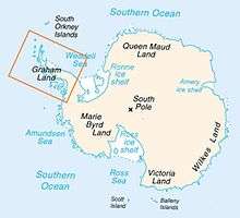
The Antarctic Peninsula is the northernmost part of the mainland of Antarctica, located at the base of the Southern Hemisphere. At the surface, it is the biggest, most prominent peninsula in Antarctica as it extends 1300 km (800 miles) from a line between Cape Adams (Weddell Sea) and a point on the mainland south of Eklund Islands. Beneath the ice sheet which covers it, the Antarctic Peninsula consists of a string of bedrock islands; these are separated by deep channels whose bottoms lie at depths considerably below current sea level. They are joined together by a grounded ice sheet. Tierra del Fuego, the southernmost tip of South America, lies only about 1000 km (620 miles) away across the Drake Passage.[1]
The Antarctic Peninsula is currently dotted with numerous research stations and nations have made multiple claims of sovereignty. The peninsula is part of disputed and overlapping claims by Argentina, Chile and the United Kingdom. None of these claims has international recognition and, under the Antarctic Treaty System, the respective countries do not attempt to enforce their claims. Argentina has the most bases and personnel stationed on the peninsula.
History

%2C_Adelaide_Island%2C_Webb_Island.JPG)
Discovery and naming
The first sighting of the Antarctic Peninsula by Europeans is disputed but apparently occurred in 1820. The most likely first sighting of the Antarctic Peninsula, and also of the whole Antarctic mainland, was probably on 27 January 1820 by an expedition of the Russian Imperial Navy led by Fabian Gottlieb von Bellingshausen. But the party did not recognize as the mainland what they thought was an icefield covered by small hillocks.
Three days later on 30 January 1820, Edward Bransfield and William Smith, with a British expedition, were the first to chart part of the Antarctic Peninsula. This area was later to be called Trinity Peninsula and is the extreme northeast portion of the peninsula. The next confirmed sighting was in 1832 by John Biscoe, a British explorer, who named the northern part of the Antarctic Peninsula as Graham Land.[1][2]
The first European to land on the continent is also disputed. A 19th-century seal hunter, John Davis, was almost certainly the first. But, sealers were secretive about their movements and their logbooks were deliberately unreliable, to protect any new sealing grounds from competition.[1]
Between 1901 and 1904, Otto Nordenskiöld led the Swedish Antarctic Expedition, one of the first expeditions to explore parts of Antarctica. They landed on the Antarctic Peninsula in February 1902, aboard the Antarctica, which later sank not far from the peninsula. All crew were saved. They were later rescued by an Argentine ship. The British Graham Land Expedition between 1934 and 1937 carried out aerial surveys and concluded that Graham Land was not an archipelago but was a peninsula.[1][2]
Agreement on the name Antarctic Peninsula by the US-ACAN and UK-APC in 1964 resolved a long-standing difference over the use of the United States' name "Palmer Peninsula" or the British name "Graham Land" for this geographic feature. This dispute was resolved by making Graham Land the part of the Antarctic Peninsula northward of a line between Cape Jeremy and Cape Agassiz; and Palmer Land the part southward of that line. Palmer Land is named for the United States seal hunter Nathaniel Palmer. In Chile, the peninsula is officially named O'Higgins Land, after Bernardo O'Higgins, the Chilean patriot and Antarctic visionary. Other Spanish-speaking countries call it "Península Antártica", among them Argentina. It officially also refers to this as Tierra de San Martín, and Argentina has more bases and personnel there than any other nation.[1]
Other portions of the peninsula named by and after the various expeditions discovered them include Bowman Coast, Black Coast, Danco Coast, Davis Coast, English Coast, Fallieres Coast, Loubet Land, Nordenskjold Coast and the Wilkins Coast.[1]
Research stations

The first Antarctic research stations were established during World War II by a British military operation, Operation Tabarin.[3]
The 1950s saw a marked increase in the number of research bases as Britain, Chile and Argentina competed to make claims over the same area.[4] Meteorology and geology were the primary research subjects.
Since the peninsula has the mildest climate in Antarctica, the highest concentration of research stations on the continent can be found there, or on the many nearby islands, and it is the part of Antarctica most often visited by tour vessels and yachts. Occupied bases include Base General Bernardo O'Higgins Riquelme, Bellingshausen Station, Comandante Ferraz Brazilian Antarctic Base, Rothera Research Station and San Martín Base. Today, on the Antarctic Peninsula there are many abandoned scientific and military bases. Ice core and sediment samples from the peninsula are valuable because events such as the Little Ice Age can be verified with samples from other continents. Argentina's Esperanza Base was the birthplace of Emilio Marcos Palma, the first person to be born in Antarctica.
Recent
Tourism to the Antarctic Peninsula began in the 1950s. Most ship-based tourists depart for the peninsula from Ushuaia in Argentina.
The grounding of the Argentine ship Bahía Paraíso and subsequent 170,000 gallon oil spill occurred near the Antarctic Peninsula in 1989.[5][6] In 2005, Lewis Gordon Pugh broke the farthest-south long distance swim record by undertaking a 1 km (0.62 mi) swim at Petermann Island off the Antarctic Peninsula. In November 2007, the MV Explorer rammed submerged sea ice and then sank after water from a fist sized hole could not be pumped out quickly enough. All passengers and crew were safely evacuated and rescued.[7]
Geography


The peninsula is highly mountainous, its highest peaks rising to about 2,800 metres (9,200 ft). Notable peaks on the peninsula include Mount Castro, Mount Coman, Mount Gilbert, Mount Jackson, which is the highest point at 3184 metres or 10,446 ft, Mount William, Mount Owen and Mount Scott. These mountains are considered to be a continuation of the Andes of South America, with a submarine spine or ridge connecting the two.[8] This is the basis for the position advanced by Chile and Argentina for their territorial claims. The Scotia Arc is the island arc system that links the mountains of the Antarctic Peninsula to those of Tierra del Fuego.
The landscape of the peninsula is typical Antarctic tundra. The peninsula has a sharp elevation gradient, with glaciers flowing into the Larsen Ice Shelf, which experienced significant breakup in 2002. Other ice shelves on the peninsula include George VI Ice Shelf, Wilkins Ice Shelf, Wordie Ice Shelf and the Bach Ice Shelf. The Filchner-Ronne Ice Shelf lies to the east of the peninsula.
Islands along the peninsula are mostly ice-covered and connected to the land by pack ice.[9] Separating the peninsula from nearby islands are the Antarctic Sound, Erebus and Terror Gulf, George VI Sound, Gerlache Strait and the Lemaire Channel. The Lemaire Channel is a popular destination for tourist cruise ships that visit Antarctica. Further to the west lies the Bellingshausen Sea and in the north is the Scotia Sea. The Antarctic Peninsula and Cape Horn create a funneling effect, which channels the winds into the relatively narrow Drake Passage.
Hope Bay, at 63°23′S 057°00′W / 63.383°S 57.000°W, is near the northern extremity of the peninsula, Prime Head, at 63º13'S. Near the tip at Hope Bay is Sheppard Point. The part of the peninsula extending northeastwards from a line connecting Cape Kater to Cape Longing is called the Trinity Peninsula. Brown Bluff is a rare tuya and Sheppard Nunatak is found here also. The Airy, Seller, Fleming and Prospect Glaciers form the Forster Ice Piedmont along the west coast of the peninsula. Charlotte Bay, Hughes Bay and Marguerite Bay are all on the west coast as well.
On the east coast is the Athene Glacier; the Arctowski and Akerlundh Nunataks are both just off the east coast. A number of smaller peninsulas extend from the main Antarctic Peninsula including Hollick-Kenyon Peninsula and Prehn Peninsula at the base of the Antarctic Peninsula. Also located here are the Scaife Mountains. The Eternity Range is found in the middle of the peninsula. Other geographical features include Avery Plateau, the twin towers of Una's Peaks.
Climate
Because the Antarctic Peninsula, which reaches north of the Antarctic Circle, is the most northerly part of Antarctica, it has the mildest climates within this continent. Its temperatures are warmest in January, averages 1 to 2 °C, and coldest in June, averages from –15 °C to –20 °C. Its west coast from the tip of the Antarctic Peninsula south to 68 degrees South, which has a maritime Antarctic climate, is the mildest part of Antarctic Peninsula. Within this part of the Antarctic Peninsula, temperatures exceed 0 °C for 3–4 months during the summer, and rarely fall below –10 °C during the winter. Farther south along the west coast and the northeast coast of the peninsula, mean monthly temperatures exceed 0 °C for only 1–2 months of summer and average around –15 °C in winter. The east coast of the Antarctic Peninsula south of 63°S is generally much colder, with mean temperatures exceeding 0 °C for only 0–1 months of summer, and winter mean temperatures ranging from –5 to –25 °C. The colder temperatures of the southeast, Weddell Sea side, of the Antarctic Peninsula are reflected in the persistence of ice shelves that cling to the eastern side.[10][11]
Precipitation varies greatly within the Antarctic Peninsula. From the tip of the Antarctic Peninsula south to 68 degrees South, precipitation averages 35–50 cm per year. A good portion of this precipitation falls as rain during the summer, on two-thirds of the days of the year, and with little seasonal variation in amounts. Between about 68°S and 63°S on the west coast of the Antarctic Peninsula and along its northeast coast, precipitation is 35 cm or less with occasional rain. Along the east coast of the Antarctic Peninsula south of 63°S, precipitation ranges from 10–15 cm. In comparison, the subantarctic islands have precipitation of 1–2 m per year and the dry interior of Antarctica is a virtual desert with only 10 cm precipitation per year.[11]
Climate change
Because of issues concerning global climate change, the Antarctic Peninsula and adjacent parts of the Weddell Sea and its Pacific continental shelf has been the subject of intensive geologic, paleontologic, and paleoclimatic research by interdisciplinary and multinational groups over the last several decades. The combined study of the glaciology of its ice sheet and the paleontology, sedimentology, stratigraphy, structural geology, and volcanology of glacial and nonglacial deposits of the Antarctic Peninsula has allowed the reconstruction of the paleoclimatology and prehistoric ice sheet fluctuation of it for over the last 100 million years. This research shows the dramatic changes in climate, which have occurred within this region after it reached its approximate position within the Antarctic Circle during the Cretaceous Period.[12][13][14][15][16]
The Fossil Bluff Group, which outcrops within Alexander Island, Antarctic Peninsula, provides a detailed record, which includes paleosols and fossil plants, of middle Cretaceous (Albian) terrestrial climates. The sediments that form the Fossil Bluff Group accumulated within a volcanic island arc, which now forms the bedrock backbone of the Antarctic Peninsula, in prehistoric floodplains and deltas and offshore as submarine fans and other marine sediments. As reflected in the plant fossils, paleosols, and climate models, the climate was warm, humid, and seasonally dry. According to climate models, the summers were dry and winters were wet. The rivers were perennial and subject to intermittent flooding as the result of heavy rainfall.[14][17]
Warm high-latitude climates reached a peak during the mid-Late Cretaceous Cretaceous Thermal Maximum. Plant fossils found within the Late Cretaceous (Coniacian and Santonian-early Campanian) strata of the Hidden Lake and Santa Maria formations, which outcrop within James Ross, Seymour, and adjacent islands, indicate that this emergent volcanic island arc enjoyed warm temperate or subtropical climates with adequate moisture for growth and without extended periods of below freezing winter temperatures.[14][18]
After the peak warmth of Cretaceous thermal maximum, the climate, both regionally and globally, appears to have cooled as seen in the Antarctic fossil wood record. Later, warm high-latitude climates returned to the Antarctic Peninsula region during the Paleocene and early Eocene as reflected in fossil plants. Abundant plant and marine fossils from Paleogene marine sediments that outcrop on Seymour Island indicate the presence of cool and moist, high-latitudes environment during the early Eocene.[12][14]
Detailed studies of the paleontology, sedimentology, and stratigraphy of glacial and nonglacial deposits within the Antarctic Peninsula and adjacent parts of the Weddell Sea and its Pacific continental shelf have found that it has become progressively glaciated as the climate of Antarctica dramatically and progressively cooled during the last 37 million years. This progressive cooling was contemporaneous with a reduction in atmospheric CO2 concentrations. During this climatic cooling, the Antarctic Peninsula was probably the last region of Antarctica to have been fully glaciated. Within the Antarctic Peninsula, mountain glaciation was initiated during the latest Eocene, about 37–34 Ma. The transition from temperate, alpine glaciation to a dynamic ice sheet occurred about 12.8 Ma. At this time, the Antarctic Peninsula formed as the bedrock islands underlying it were overridden and joined together by an ice sheet in the early Pliocene about 5.3–3.6 Ma. During the Quaternary Period, the size of the West Antarctic Ice Sheet has fluctuated in response to glacial - interglacial cycles. During glacial epochs, this ice sheet was significantly thicker than it is currently is and extended to the edge of the continental shelves. During interglacial epochs, the West Antarctica Ice Sheet was thinner than during glacial epochs and its margins lay significantly inland of the continental margins.[12][13][14]

During the Last Glacial Maximum, about 20,000 to 18,000 years ago, the ice sheet covering the Antarctic Peninsula was significantly thicker than it is now. Except for a few isolated nunataks, the Antarctic Peninsula and its associated islands were completely buried by the ice sheet. In addition, the ice sheet extended past the present shoreline onto the Pacific outer continental shelf and completely filled the Weddell Sea up to the continental margin with grounded ice.[12][15][16][19]

The deglaciation of the Antarctic Peninsula largely occurred between 18,000 and 6,000 years ago as an interglacial climate was established in the region. It initially started about 18,000 to 14,000 years ago with retreat of the ice sheet from the Pacific outer continental shelf and the continental margin within the Weddell Sea. Within the Weddell Sea, the transition from grounded ice to a floating ice shelf occurred about 10,000 years ago. The deglaciation of some locations within the Antarctic Peninsula continued until 4,000 to 3,000 years ago. Within the Antarctic Peninsula, an interglacial climatic optimum occurred about 3,000 to 5,000 years ago. After the climate optimum, a distinct climate cooling, which lasted until historic times, occurred.[15][16][19][20]
The Antarctic Peninsula is a part of the world that is experiencing extraordinary warming.[21] Each decade for the last five, average temperatures in the Antarctic Peninsula have risen by half a degree Celsius.[22] Ice mass loss on the peninsula occurred at a rate of 60 billion tonnes in 2006,[23] with the greatest change occurring in the northern tip of the peninsula.[24] Seven ice shelves along the Antarctic Peninsula have retreated or disintegrated in the last two decades.[21] Research by the United States Geological Survey has revealed that every ice front on the southern half of the peninsula experienced a retreat between 1947 and 2009.[25] According to a study by the British Antarctic Survey, glaciers on the peninsula are not only retreating but also increasing their flow rate as a result of increased buoyancy in the lower parts of the glaciers.[26] Professor David Vaughan has described the disintegration of the Wilkins Ice Shelf as the latest evidence of rapid warming in the area.[27] The Intergovernmental Panel on Climate Change has been unable to determine the greatest potential effect on sea level rise that glaciers in the region may cause.[26]
Flora and fauna


The coasts of the peninsula have the mildest climate in Antarctica and moss and lichen-covered rocks are free of snow during the summer months, although the weather is still intensely cold and the growing season very short. The plant life today is mainly mosses, lichens and algae adapted to this harsh environment, with lichens preferring the wetter areas of the rocky landscape. The most common lichens are Usnea and Bryoria species. Antarctica's two flowering plant species, the Antarctic hair grass (Deschampsia antarctica) and Antarctic pearlwort (Colobanthus quitensis) are found on the northern and western parts of the Antarctic Peninsula, including offshore islands, where the climate is relatively mild. Lagotellerie Island in Marguerite Bay is an example of this habitat.[10][11][28]
Antarctic krill are found in the seas surrounding the peninsula and the rest of the continent. The crabeater seal spends most of its life in the same waters feeding on krill. Bald notothen is a cryopelagic fish that lives in sub-zero water temperatures around the peninsula. Vocalizations of the sei whale can be heard emanating from the waters surrounding the Antarctic Peninsula.[10]
The animals of Antarctica live on food they find in the sea—not on land—and include seabirds, seals and penguins. The seals include: leopard seal (Hydrurga leptonyx), Weddell seal (Leptonychotes weddellii), the huge southern elephant seal (Mirounga leonina), and crabeater seal (Lobodon carcinophagus).[10]
Penguin species found on the peninsula, especially near the tip and surrounding islands, include the chinstrap penguin, emperor penguin, gentoo penguin and the Adelie penguin. Petermann Island is the world's southernmost colony of gentoo penguins. The exposed rocks on the island is one of many locations on the peninsula that provides a good habitat for rookeries. The penguins return each year and may reach populations of more than ten thousand. Of these the most common on the Antarctic Peninsula are the chinstrap and gentoo, with the only breeding colony of emperor penguins in West Antarctica an isolated population on the Dion Islands, in Marguerite Bay on the west coast of the peninsula. Most emperor penguins breed in East Antarctica[10][11][28]
Seabirds of the Southern Ocean and West Antarctica found on the peninsula include: southern fulmar (Fulmarus glacialoides), the scavenging southern giant petrel (Macronectes giganteus), Cape petrel (Daption capense), snow petrel (Pagodroma nivea), the small Wilson's storm-petrel (Oceanites oceanicus), imperial shag (Phalacrocorax atriceps), snowy sheathbill (Chionis alba), the large south polar skua (Catharacta maccormicki), brown skua (Catharacta lönnbergi), kelp gull (Larus dominicanus), and Antarctic tern (Sterna vittata). The imperial shag is a cormorant which is native to many subantarctic islands, the Antarctic Peninsula and southern South America.[10][11]
Threats and preservation
Although this very remote part of the world has never been inhabited and is protected by the Antarctic Treaty System, which bans industrial development, waste disposal and nuclear testing, there is still a threat to these fragile ecosystems from increasing tourism, primarily on cruises across the Southern Ocean from the port of Ushuaia, Argentina.
Paleofloras and paleofaunas

A rich record of fossil leaves, wood, pollen, and flowers demonstrates that flowering plants thrived in subtropical climates within the volcanic island arcs that occupied the Antarctic Peninsula region during the Cretaceous and very early Paleogene periods. The analysis of fossil leaves and flowers indicate that semitropical woodlands, which were composed of ancestors of plants that live in the tropics today, thrived within this region during a global thermal maximum with summer temperatures that averaged 20 °C. The oldest fossil plants come from the middle Cretaceous (Albian) Fossil Bluff Group, which outcrop along the edge of Alexander Island. These fossils reveal that at this time the forests consisted of large conifers, with mosses and ferns in the undergrowth. The paleosols, in which trees are rooted, have physical characteristics indicative of modern soils that form under seasonally dry climates periodic high rainfall.[17] Younger Cretaceous strata, which outcrop within James Ross, Seymour, and adjacent islands, contain plants fossil of Late Cretaceous angiosperms with leaf morphotypes that are similar to those of living families such as Sterculiaceae, Lauraceae, Winteraceae, Cunoniaceae, and Myrtaceae. They indicate that the emergent parts of the volcanic island arc, the eroded roots of which now formed the central part of the Antarctic Peninsula, were covered by either warm temperate or subtropical forests.[18] These fossil plants are indicative of tropical and subtropical forest at high paleolatitudes during the Middle and Late Cretaceous, which grew in climates without extended periods of below freezing winter temperatures and with adequate moisture for growth.[14] The Cretaceous strata of James Ross Island also yielded the dinosaur genera Antarctopelta, which was the first dinosaur fossil to be found on Antarctica.[29]
Paleogene and Early Eocene marine sediments that outcrop on Seymour Island contains plant-rich horizons. The fossil plants are dominated by permineralized branches of conifers and compressions of angiosperm leaves, and found within carbonate concretions. These fossils, which date to about 51.5-49.5 Ma, are dominated by leaves, cone scales, and leafy branches of araucarian conifers, very similar in all respects to living Araucaria araucana (monkey puzzle) from Chile. They suggest that the adjacent parts of the prehistoric Antarctic Peninsula were covered by forests that grew in a cool and moist, high-latitudes environment during the early Eocene.[14]
During the Cenozoic climatic cooling, the Antarctic Peninsula was the last region of Antarctica to have been fully glaciated according to current research. As a result, this region was probably the last refugium for plants and animals that had inhabited Antarctica after it separated from the Gondwanaland supercontinent. Analysis of paleontologic, stratigraphic, and sedimentologic data acquired from the study of drill core and seismic acquired during the Shallow Drilling on the Antarctic Continental Shelf (SHALDRIL) and other projects and from fossil collections from and rock outcrops within Alexander, James Ross, King George, Seymour, and South Shetland Islands has yielded a record of the changes in terrestrial vegetation that occurred within the Antarctic Peninsula over the course of the past 37 million years.[13][14]
This research found that vegetation within the Antarctic Peninsula changed in response to a progressive climatic cooling that started with the initiation of mountain glaciation in the latest Eocene, about 37–34 Ma. The cooling was contemporaneous with glaciation elsewhere in Antarctica and a reduction in atmospheric CO2 concentrations. Initially, during the Eocene, this climate cooling resulted in a decrease in diversity of the angiosperm-dominated vegetation that inhabited the northern Antarctic Peninsula. During the Oligocene, about 34–23 Ma, these woodlands were replaced by a mosaic of southern beech (Nothofagus) and conifer-dominated woodlands and tundra as the climate continued to cool. By middle Miocene, 16–11.6 Ma, a tundra landscape completely replaced any remaining woodlands. At this time, woodlands became completely extirpated from the Antarctic Peninsula and all of Antarctica. A tundra landscape probably persisted until about 12.8 Ma when the transition from a temperate, alpine glaciation to a dynamic ice sheet occurred. Eventually, the Antarctic Peninsula was overridden by an ice sheet, which has persisted without any interruption to this day, in the early Pliocene, about 5.3–3.6 Ma.[13][14]
See also
- Argentina–Chile relations#Border issues
- Bransfield Strait
- Geology of the Antarctic Peninsula
- Instituto Antártico Argentino
References
- 1 2 3 4 5 6 Stewart, J. (2011) Antarctic An Encyclopedia McFarland & Company Inc, New York. 1776 pp. ISBN 978-0-7864-3590-6.
- 1 2 Scott, Keith (1993). The Australian Geographic book of Antarctica. Terrey Hills, New South Wales: Australian Geographic. pp. 114—118. ISBN 1-86276-010-1.
- ↑ "British Research Stations and Refuges - History". British Antarctic Survey. Retrieved 8 November 2014.
- ↑ Thomson, Michael; Charles Swithinbank (1 August 1985). "The prospects for Antarctic Minerals". New Scientist (1467): 31–35.
- ↑ "The world's frozen clean room". Business Week. 22 January 1990.
- ↑ Smith, James F. (5 April 1990). "Struggling to Protect 'The Ice'". Los Angeles Times. Retrieved 2011-01-30.
- ↑ "Stricken Antarctic ship evacuated". British Broadcasting Corporation. 24 November 2007. Retrieved 2009-07-22.
- ↑ "Operation IceBridge Returns to Antarctica". NASA Earth Observatory. NASA. October 15, 2011. Retrieved 15 October 2011.
- ↑ Tulloch, Coral (2003). Antarctica: Heart of the World. Sydney: ABC Books. p. 40. ISBN 0-7333-0912-7.
- 1 2 3 4 5 6 Moss, S. (1988) Natural History of The Antarctic Peninsula Columbia University Press, New York, New York. 208 pp. ISBN 978-0-231-06269-5
- 1 2 3 4 5 World Wildlife Fund and S. Draggan. (2009) Antarctic Peninsula. in C. J. Cleveland, ed., Encyclopedia of Earth. National Council for Science and the Environment, Washington, DC
- 1 2 3 4 Anderson, J.B. (1999) Antarctic Marine Geology. Cambridge University Press. University of Cambridge, Cambridge, United Kingdom. 297 pp. ISBN 978-0-521-59317-5.
- 1 2 3 4 Anderson, J.B., S. Warny, R.A. Askin, J.S. Wellner, S.M. Bohaty, A.E. Kirshner, D.N. Livsey, A.R. Simms, Tyler R. Smith, W. Ehrmann, L.A. Lawverh, D. Barbeaui, S.W. Wise, D.K. Kulhanek, F.M. Weaver, and W. Majewski (2012) Progressive Cenozoic cooling and the demise of Antarctica’s last refugium. Proceedings of the National Academy of Sciences. 108:11356-11360.
- 1 2 3 4 5 6 7 8 9 Francis, J. E., A. Ashworth, D.J. Cantrill, J.A. Crame, J. Howe, R. Stephens, A.-M. Tosolini, and V. Thorn (2008) 100 Million Years of Antarctic Climate Evolution: Evidence from Fossil Plants in A. K. Cooper, P. J. Barrett, H. Stagg, B. Storey, E. Stump, W. Wise, and the 10th ISAES editorial team, eds., pp. 19-27, Antarctica: A Keystone in a Changing World. Proceedings of the 10th International Symposium on Antarctic Earth Sciences. The National Academies Press, Washington, DC.
- 1 2 3 Heroy, D.C., and J.B. Anderson (2005) Ice-sheet extent of the Antarctic Peninsula region during the Last Glacial Maximum (LGM) — insights from glacial geomorphology. Geological Society of America Bulletin 117:11:1497–1512.
- 1 2 3 Ingolfsson, O., C. Hjort, and O. Humlum (2003) Glacial and Climate History of the Antarctic Peninsula since the Last Glacial Maximum. Arctic, Antarctic, and Alpine Research. 35:2:175–186.
- 1 2 Falcon-Lang, H. J., D. J. Cantrill, and G. J. Nichols. (2001) Biodiversity and terrestrial ecology of a mid-Cretaceous, high-latitude floodplain, Alexander Island, Antarctica. Journal of the Geological Society of London. 158:709-724.
- 1 2 Hayes, P. A., J. E. Francis, and D. J. Cantrill, (2006) Palaeoclimate of Late Cretaceous Angiosperm leaf floras, James Ross Island, Antarctic. in J. E. Francis, D. Pirrie, and J. A. Crame, eds., pp, 49-62, Cretaceous-Tertiary High Latitude Palaeoenvironments, James Ross Basin. Geological Society London Special Publication. 258:49-62.
- 1 2 Livingstone, S.J., C.O. Cofaigh, C.R. Stokes, C.-D. Hillenbrand, A. Vieli, and S.S.R. Jamieson (2011) Antarctic palaeo-ice streams. Earth-Science Reviews. Available online 25 October 2011.
- ↑ Johnson, J.S. M.J. Bentley, S.J. Roberts, S.A. Binnie, and S.P.H.T. Freeman (2011) Holocene deglacial history of the northeast Antarctic Peninsula - A review and new chronological constraints. Quaternary Science Reviews. 30:3791-3802.
- 1 2 "Even The Antarctic Winter Cannot Protect Wilkins Ice Shelf". Science Daily. 14 June 2008. Archived from the original on 17 June 2008. Retrieved 2008-06-18.
- ↑ "Satellites Shed Light On Global Warming". TerraDaily.com. 29 April 2007. Retrieved 2011-01-30.
- ↑ "Antarctic Ice Loss". TerraDaily.com. 14 January 2008. Retrieved 2008-03-29.
- ↑ "Antarctic Heating and Cooling Trends". Goddard Space Flight Center. NASA. Retrieved 2008-03-29.
- ↑ Ferrigno, J.G. A.J. Cook, A.M. Mathie, R.S. Williams, Jr., C. Swithinbank, K.M. Foley, A.J. Fox, J.W. Thomson, and J.Sievers (2009) Coastal-Change and Glaciological Map of the Palmer Land Area, Antarctica: 1947—2009. Geologic Investigations Series Map no. I-2600-C, United States Geological Survey, Reston, Virginia.
- 1 2 "Hundreds Of Antarctic Peninsula Glaciers Accelerating As Climate Warms". Science Daily. 6 June 2007. Archived from the original on 5 July 2008. Retrieved 2008-07-09.
- ↑ "Wilkins Ice Shelf hanging by its last thread". European Space Agency. 10 July 2008. Archived from the original on 8 August 2008. Retrieved 2008-08-08.
- 1 2 World Wildlife Fund, C. M. Hogan, S. Draggan. (2011) Marielandia Antarctic tundra. in C. J. Cleveland, ed., Encyclopedia of Earth. National Council for Science and the Environment, Washington, DC
- ↑ Salgado, L., and Z. Gasparini (2006) Reappraisal of an ankylosaurian dinosaur from the Upper Cretaceous of James Ross Island (Antarctica). Geodiversitas. v. 28, no. 11, pp. 119-135.
External links
| Wikivoyage has a travel guide for Antarctic Peninsula. |
| Wikimedia Commons has media related to Antarctic Peninsula. |
- "Of Ice and Men" Account of a tourist visit to the Antarctic Peninsula by Roderick Eime
- Biodiversity at Ardley Island, South Shetland archipelago, Antarctic Peninsula
- 89 photos of the Antarctic Peninsula
| General | .svg.png) | |
|---|---|---|
| Geographic regions | ||
| Waterways | ||
| Famous explorers | ||
Coordinates: 69°30′S 65°00′W / 69.500°S 65.000°W