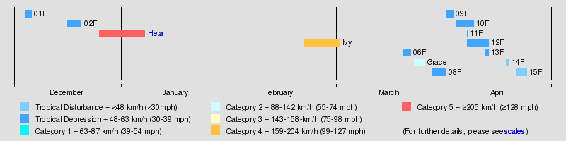
2003–04 South Pacific cyclone season
 | |
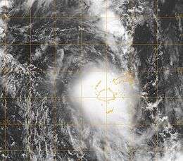
| Season summary map | |
| First system formed | December 4, 2003 |
|---|---|
| Last system dissipated | April 24, 2004 |
| Strongest storm1 | Heta – 915 hPa (mbar), 215 km/h (130 mph) (10-minute sustained) |
| Total disturbances | 15 |
| Total depressions | 12 |
| Tropical cyclones | 3 |
| Severe tropical cyclones | 2 |
| Total fatalities | 16 |
| Total damage | $387 million (2004 USD) |
| 1Strongest storm is determined by lowest pressure | |
2001–02, 2002–03, 2003–04, 2004–05, 2005–06 | |
| Related articles | |
The 2003–04 South Pacific cyclone season was a below-average season with only three tropical cyclones occurring within the South Pacific to the east of 160°E. The season officially ran from November 1, 2003 to April 30, 2004 with the first disturbance of the season forming on December 4 and the last disturbance dissipating on April 23.[A 1][A 2] This is the period of the year when most tropical cyclones form within the South Pacific Ocean.[1]
During the season at least 16 people were killed from tropical disturbances whilst overall damage was estimated at $218 million (2004 USD; $273 million 2016 USD). The most damaging tropical disturbance was Cyclone Heta which caused at least $211 million (2004 USD; $265 million 2016 USD) in damage to six different countries and left three dead.[2][3][4] The deadliest tropical disturbance of the season was Tropical Depression 10F, which was responsible for eleven deaths and caused $2.74 million (2004 USD) in damage.[5] Cyclone Ivy also caused 2 deaths and caused $4.17 million (2004 USD; $5.24 million 2016 USD) worth of damage to Vanuatu.[2][6] As a result of the impacts caused by Heta and Ivy, the names were retired from the tropical cyclone naming lists.[1]
Within the South Pacific, tropical cyclones are monitored by the Regional Specialized Meteorological Center (RSMC) in Nadi, Fiji, and the Tropical Cyclone Warning Center (TCWC) in Wellington, New Zealand. RSMC Nadi attaches a number and an F suffix to tropical disturbances that form in or move into the South Pacific. The United States Joint Typhoon Warning Center (JTWC) issues unofficial warnings within the South Pacific, designating tropical cyclones with a number and a P suffix. RSMC Nadi and TCWC Wellington both use the Australian Tropical Cyclone Intensity Scale, and measure windspeeds over a period of ten minutes, while the JTWC measures sustained winds over a period of one minute and uses the Saffir–Simpson Hurricane Scale.
Seasonal summary
Storms
Tropical Disturbance 02F
| Tropical disturbance (Australian scale) | |||
|---|---|---|---|
| |||
| Duration | December 16 – December 20 | ||
| Peak intensity | Winds not specified 1002 hPa (mbar) | ||

For several days, a tropical disturbance persisted in the south Pacific, lasting from December 16–20.
Severe Tropical Cyclone Heta
| Category 5 severe tropical cyclone (Australian scale) | |||
|---|---|---|---|
| Category 5 tropical cyclone (SSHWS) | |||
| |||
| Duration | December 28 – January 7 | ||
| Peak intensity | 215 km/h (130 mph) (10-min) 915 hPa (mbar) | ||
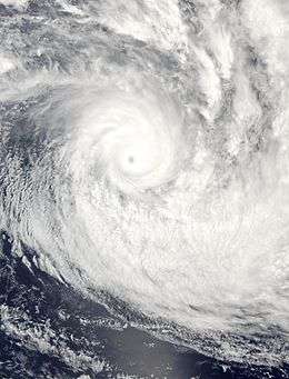
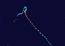
Cyclone Heta developed in the South Pacific Ocean and reached cyclone-force winds on January 1, 2004. It struck the island of Niue with a much more direct blow on January 6. Heta's eyewall hit Niue almost exactly at the height of the storm's power. It caused extensive property damage throughout the island, and two people were killed. Efforts to rebuild from the storm in Niue lasted almost the entire year of 2004.
Heta caused American Samoa to declare a state of emergency (officially a "Declaration of Emergency" in American Samoan law) on January 7, and even though officially the storm never made landfall there, it necessitated the emergency evacuation of 140 people and was responsible for property damage.[7]
The nation of Tonga was also affected by Heta, as the winds swept away trees that were needed for the country's food supply. However, Tonga did not receive a direct hit or suffer such extensive loss as Niue.
Severe Tropical Cyclone Ivy
| Category 4 severe tropical cyclone (Australian scale) | |||
|---|---|---|---|
| Category 3 tropical cyclone (SSHWS) | |||
| |||
| Duration | February 21 – February 28 | ||
| Peak intensity | 165 km/h (105 mph) (10-min) 935 hPa (mbar) | ||
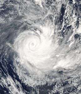

Numbered 05F. Existed between February 21 and February 28. Caused heavy damage in Vanuatu.[8]
Tropical Depression 06F
Formed on March 20, dumped heavy rainfall in Vanuatu.[9][10]
Tropical Cyclone Grace
| Category 2 tropical cyclone (Australian scale) | |||
|---|---|---|---|
| Tropical storm (SSHWS) | |||
| |||
| Duration | March 21 – March 23 | ||
| Peak intensity | 95 km/h (60 mph) (10-min) 985 hPa (mbar) | ||


Entered the region from the west on March 23, became extratropical the next day.[11] Designated as 07F by Nadi.[9]
Tropical Depression 08F
Existed between March 28 and April 1.[9]
Tropical Depression 09F
Existed between April 1 and April 3.[12]
Tropical Depression 10F
| Tropical depression (Australian scale) | |||
|---|---|---|---|
| Tropical storm (SSHWS) | |||
| |||
| Duration | April 5 – April 9 | ||
| Peak intensity | 55 km/h (35 mph) (10-min) 995 hPa (mbar) | ||

Existed between April 6 and April 9. The storm was given the number 22P by the Joint Typhoon Warning Center. It was responsible for causing severe flooding to Fiji and 11 deaths.[12][13][14] Damage from the flooding was estimated at US$2.6 million.[15]
Tropical Depression 11F
Existed on April 7.[12]
Tropical Depression 12F
Formed on April 7, later caused severe flooding in Fiji.[12]
Tropical Depression 13F
During April 11 a weak tropical low moved into the South Pacific basin from the Australian region, and was designated as Tropical Disturbance 13F by RSMC Nadi later that day.[12]
Other systems
The first numbered tropical disturbance of the season developed within a large area of convection on December 4, to the northwest of the Fijian dependency of Rotuma.[16] During that day the depression slowly moved west, before it was classified as a weak tropical depression during the next day.[17][18] The system subsequently weakened and lost its organisation because of moderate to strong vertical windshear and was last noted during December 6.[19][20] Tropical Disturbance 02F was subsequently first noted on December 16, to the northwest of the Solomon Island of San Cristobal.[21] The system subsequently moved westwards within an area that was conducive for further development
On April 18, RSMC Nadi reported that Tropical Disturbance 15F had developed within the monsoon trough, about 515 km (320 mi) to the northeast of Nukuʻalofa in Tonga.[12][22] During that day, the disturbance moved through the Tongan archipelago, before it was last noted later that day.[12] During April 22, RSMC Nadi reported that Tropical Disturbance 15F had developed about 500 km (310 mi) to the northeast of the Solomon Islands.[23] Over the next few days the disturbance remained near stationary, weak and disorganized, before it was last noted during April 24.[12][24]
Season effects
This table lists all the storms that developed in the South Pacific to the east of longitude 160°E during the 2003–04 season.
| Name | Dates active | Peak classification | Sustained wind speeds |
Pressure | Land areas affected | Damage (USD) |
Deaths | Refs |
|---|---|---|---|---|---|---|---|---|
| 01F | December 4 – 6 | Tropical Depression | Not Specified | 1005 hPa (29.68 inHg) | None | None | None | |
| 02F | December 16 – 20 | Tropical Disturbance | ||||||
| Heta | December 25, 2003 – January 8, 2004 | Category 5 severe tropical cyclone | 215 km/h (130 mph) | 915 hPa (27.02 inHg) | Samoan Islands, Niue, Tonga, Wallis and Futuna | $225 million | 3 | [25][26][27][28] |
| 04F | ||||||||
| Ivy | February 21 – 28 | Category 4 severe tropical cyclone | 165 km/h (105 mph) | 935 hPa (27.61 inHg) | ||||
| 06F | ||||||||
| Grace | March 21 – 23 | Category 2 tropical cyclone | 95 km/h (60 mph) | 985 hPa (29.11 inHg) | ||||
| 08F | ||||||||
| 09F | ||||||||
| 10F | April 5 – 9 | Tropical Depression | 55 km/h (35 mph) | 995 hPa (29.38 inHg) | ||||
| 11F | ||||||||
| 12F | ||||||||
| 13F | ||||||||
| 14F | April 18–19 | Tropical Disturbance | Not Specified | 1006 hPa (29.71 inHg) | Tonga | None | None | [22] |
| 15F | April 22–24 | Tropical Disturbance | Not Specified | 1006 hPa (29.71 inHg) | None | None | None | [23] |
| Season Aggregates | ||||||||
| 15 systems | December 4 – April 24 | 215 km/h (130 mph) | 915 hPa (27.02 inHg) | |||||
See also
- List of Southern Hemisphere tropical cyclone seasons
- Atlantic hurricane seasons: 2003, 2004
- Pacific hurricane seasons: 2003, 2004
- Pacific typhoon seasons: 2003, 2004
- North Indian Ocean cyclone seasons: 2003, 2004
Notes
References
- 1 2 "Tropical Cyclone Operational Plan for the South Pacific and South-East Indian Ocean (2008 Edition)" (PDF). World Meteorological Organization. Archived (PDF) from the original on May 22, 2009. Retrieved May 26, 2010.
- 1 2 "Economic impact of Natural Disasters on development in the Pacific" (PDF). Australian Agency for International Development, University of the South Pacific. Pacific Disaster.net. 2005. Archived from the original (PDF) on February 25, 2010. Retrieved June 2, 2010.
- ↑ "Tropical Cyclone Season Summary 2003–04" (PDF). Fiji Meteorological Service. August 29, 2007. Archived (PDF) from the original on July 27, 2010. Retrieved November 15, 2012.
- ↑ "American Samoa Event Report: Tropical Cyclone Heta". National Climatic Data Center. 2004. Archived from the original on April 18, 2010. Retrieved June 2, 2010.
- ↑ "Tropical Cyclone Country reports: 2006–08 Fiji" (PDF). Fiji Meteorological Service. World Meteorological Organization. Archived (PDF) from the original on June 2, 2010. Retrieved June 2, 2010.
- ↑ "A Special Submission to the UN Committee for Development Policy on Vanuatu's LDC Status" (PDF). United Nations. March 4, 2009. Archived (PDF) from the original on February 25, 2010. Retrieved August 7, 2009.
- ↑ "Summary of South Pacific and South Indian Ocean Tropical Cyclones". 2004 Annual Tropical Cyclone Report. Joint Typhoon Warning Center. Retrieved December 2, 2007.
- ↑ Monthly Global Tropical Cyclone Summary February 2004
- 1 2 3 Monthly Global Tropical Cyclone Summary March 2004
- ↑ "Tropical depression affects south of Vanuatu". Radio New Zealand International. March 22, 2004. Retrieved September 18, 2011.
- ↑ "Tropical Cyclone Information for Australia and Southern Hemisphere". Australian Bureau of Meteorology. Retrieved December 2, 2007.
- 1 2 3 4 5 6 7 8 Padgett, Gary. "Monthly Global Tropical Cyclone Summary April 2004". Archived from the original on November 10, 2012. Retrieved November 10, 2012.
- ↑ "Floods hit Fiji". The New Zealand Herald. June 5, 2004.
- ↑ The South Pacific and southeast Indian Ocean tropical cyclone season 2003–04
- ↑ "Fiji flood bill tipped to be over $2.6 million". The New Zealand Herald. April 18, 2004.
- ↑ RSMC Nadi Tropical Cyclone Centre (December 4, 2003). "Tropical Disturbance Summary December 4, 2003 00z". Fiji Meteorological Service. Retrieved July 13, 2015.
- ↑ RSMC Nadi Tropical Cyclone Centre (December 4, 2003). "Tropical Disturbance Summary December 4, 2003 23z". Fiji Meteorological Service. Retrieved July 13, 2015.
- ↑ RSMC Nadi Tropical Cyclone Centre (December 5, 2003). "Tropical Disturbance Summary December 5, 2003 09z". Fiji Meteorological Service. Retrieved July 13, 2015.
- ↑ Padgett, Gary (October 26, 2006). "Monthly Global Tropical Cyclone Summary December 2003". Retrieved July 13, 2015.
- ↑ RSMC Nadi Tropical Cyclone Centre (December 6, 2003). "Tropical Disturbance Summary December 6, 2003 23z". Fiji Meteorological Service. Retrieved July 13, 2015.
- ↑ RSMC Nadi Tropical Cyclone Centre (December 16, 2003). "Tropical Disturbance Summary December 16, 2003 23z". Fiji Meteorological Service. Retrieved July 13, 2015.
- 1 2 RSMC Nadi – Tropical Cyclone Centre (April 19, 2004). "Tropical Disturbance Summary April 19, 2004 00z". Fiji Meteorological Service.
- 1 2 RSMC Nadi – Tropical Cyclone Centre (April 22, 2004). "Tropical Disturbance Summary April 22, 2004 01z". Fiji Meteorological Service.
- ↑ RSMC Nadi – Tropical Cyclone Centre (April 24, 2004). "Tropical Disturbance Summary April 24, 2004 01z". Fiji Meteorological Service.
- ↑ Université Catholique de Louvain. "EM-DAT: The OFDA/CRED International Disaster Database for North America". Retrieved 2014-05-03.
- ↑ McKenzie, Emily; Prasad, Binman; Kaloumaira, Atu (2005). "Economic Impact of Natural Disasters on development in the Pacific Volume 1: Research Report" (PDF). South Pacific Applied Geoscience Commission. pp. 10–89. Archived from the original (PDF) on February 25, 2010. Retrieved June 29, 2010.
- ↑ RSMC Nadi — Tropical Cyclone Centre (2005). "RSMC Nadi Tropical Cyclone Seasonal Summary 2003–04" (PDF). Fiji Meteorological Service. Archived (PDF) from the original on June 27, 2010. Retrieved July 27, 2010.
- ↑ Unattributed (2003). "Storm events for American Samoa: Severe Tropical Cyclone Heta". National Climatic Data Center. National Oceanic and Atmospheric Administration. Archived from the original on April 17, 2010. Retrieved July 31, 2010.
External links
- World Meteorological Organization
- Australian Bureau of Meteorology
- Fiji Meteorological Service
- Meteorological Service of New Zealand
- Joint Typhoon Warning Center
Tropical cyclones of the 2003–04 South Pacific cyclone season | ||
|---|---|---|
| ||
| ||