Wa Self-Administered Division
| Wa Self-Administered Division | ||
|---|---|---|
| Self-Administered Division | ||
| ||
 | ||
| Coordinates: 22°10′00″N 99°10′00″E / 22.16667°N 99.16667°ECoordinates: 22°10′00″N 99°10′00″E / 22.16667°N 99.16667°E | ||
| Country |
| |
| State | Shan State | |
| Capital |
Hopang (de jure) Pangkham (de facto) | |
| Elevation[1] | 524 m (1,719 ft) | |
| Population | ||
| • Total | 558,000 | |
| Time zone | MST (UTC+6:30) | |

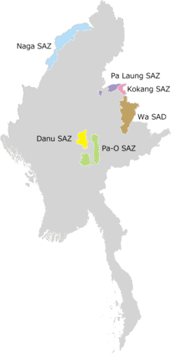
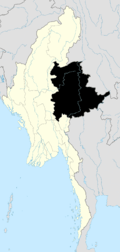
The Wa Self-Administered Division (Burmese: ဝ ကိုယ်ပိုင်အုပ်ချုပ်ခွင့်ရ တိုင်း [wa̰ kòbàɪɴ ʔoʊʔtɕʰoʊʔ kʰwɪ̰ɴja̰ táɪɴ]) is an autonomous self-administered division in Myanmar (Burma). Its official name was announced by decree on 20 August 2010.[2]
The area was declared by the government to be self-administered by the Wa people, and is currently administered under the government of the de facto independent Wa State, under the official name Wa Special Region 2.
Administrative divisions
As stipulated by the 2008 constitution, the administrative region consists of the following townships in Shan State:[3]
- Hopang District
- Matman District
- Matman Township (Metman)
- Namphan Township (Nahpan)
- Pangsang Township (Pangkham)
References
- ↑ GoogleEarth
- ↑ "တိုင်းခုနစ်တိုင်းကို တိုင်းဒေသကြီးများအဖြစ် လည်းကောင်း၊ ကိုယ်ပိုင်အုပ်ချုပ်ခွင့်ရ တိုင်းနှင့် ကိုယ်ပိုင်အုပ်ချုပ်ခွင့်ရ ဒေသများ ရုံးစိုက်ရာ မြို့များကို လည်းကောင်း ပြည်ထောင်စုနယ်မြေတွင် ခရိုင်နှင့်မြို့နယ်များကို လည်းကောင်း သတ်မှတ်ကြေညာ". Weekly Eleven News (in Burmese). 2010-08-20. Retrieved 2010-08-23.
- ↑ ပြည်ထောင်စုသမ္မတမြန်မာနိုင်ငံတော် ဖွဲ့စည်းပုံအခြေခံဥပဒေ (၂၀၀၈ ခုနှစ်) (in Burmese) [0]=1|2008 Constitution PDF
See also
| States | ||
|---|---|---|
| Regions | ||
| Self-Administered Zones | ||
| Self-Administered Divisions | ||
| Union Territories | ||

This article is issued from Wikipedia - version of the 10/14/2016. The text is available under the Creative Commons Attribution/Share Alike but additional terms may apply for the media files.