Kengtung District
This article is about the district. For the township, see Kengtung Township. For the city, see Kengtung. For the former state, see Kengtung State.
| Kengtung ကျိုင်းတုံ | |
|---|---|
| District | |
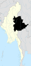
 Kengtung Location in Burma | |
| Coordinates: 21°35′00″N 99°35′00″E / 21.58333°N 99.58333°ECoordinates: 21°35′00″N 99°35′00″E / 21.58333°N 99.58333°E | |
| Country |
|
| State | Shan State |
| Elevation[1] | 807 m (2,648 ft) |
| Time zone | MST (UTC+6.30) |
Kengtung District (Burmese: ကျိုင်းတုံခရိုင်; also spelled Kengtong) is a district of the Shan State in Myanmar. It consists of 3 towns and 1449 villages.
Townships
The district contains the following townships:
- Kengtung Township, Kengtung is the largest, most mountainous, most easterly, and culturally the farthest from the Burmese, of all the Shan States. Geography makes approach to it from the rest of Burma difficult for it lies not only beyond the Salween across which no bridge has been built and whose eastern tributaries have cut no easy routes through the serried north-south ranges, but nearer again to the Mekong than to the Salween.[2]
- Mong Khet Township
- Mong Yang Township
- Mong La Township
- Mat Man Township, Matman (Maman) Township became part of Hopang District instead part of Kengtung District after September 2011.[3]
References

This article is issued from Wikipedia - version of the 11/23/2015. The text is available under the Creative Commons Attribution/Share Alike but additional terms may apply for the media files.