Mong Nai Township
This article is about the present-day administrative division. For the former Shan princely state, see Mongnai State. For the town, see Mong Nai.
| Mong Nai | |
|---|---|
| Township | |
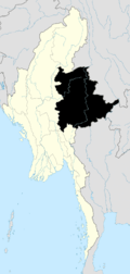
 Mong Nai Location in Burma | |
| Coordinates: 20°31′N 97°52′E / 20.517°N 97.867°ECoordinates: 20°31′N 97°52′E / 20.517°N 97.867°E | |
| Country |
|
| State | Shan State |
| District | Loilem District |
| Time zone | MST (UTC+6.30) |
Mong Nai Township is a township of Loilem District in the Shan State of Myanmar.[1] The main town is Mong Nai.
Geography
The Salween River bounds it on the east. The main area consists of two plains with a ridge between them. There is much flat rice bottom, but a considerable portion consists of gently undulating mainland. In the central plain, rice is the only crop. Outside this considerable quantities of sugar are produced.
References
- ↑ "Myanmar States/Divisions & Townships Overview Map" Myanmar Information Management Unit (MIMU)
Capital: Möng Nai | |
|

This article is issued from Wikipedia - version of the 2/6/2016. The text is available under the Creative Commons Attribution/Share Alike but additional terms may apply for the media files.