Laukkaing Township
| Laukkaing | |
|---|---|
| Township | |
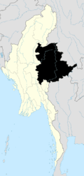
 Laukkaing Location in Burma | |
| Coordinates: 23°41′00″N 98°45′00″E / 23.68333°N 98.75000°ECoordinates: 23°41′00″N 98°45′00″E / 23.68333°N 98.75000°E | |
| Country |
|
| State | Shan State |
| Self-administered zone | Kokang |
| Elevation[1] | 991 m (3,251 ft) |
| Time zone | MST (UTC+6.30) |
Laukkaing Township (Burmese: လောက်ကိုင်မြို့နယ်) is a township located within Laukkaing District, Shan State, Myanmar. It is also part of the Kokang Self-Administered Zone. The principal town is Laukkai aka Laukkaing.
Geography
It is sharing a border with Kongyan Township and People's Republic of China in the north, People's Republic of China in the east, Kunlong Township in the south and Kutkai Township in the west. It has 31 border posts. It is situated at 3,100 feet (940 m) above sea level. Few plains can be seen in Laukkai, Mangtonpa, Yanlongkyaing, Pasinkyaw and Namhuhtan. The remaining area is mountainous and from 3,000 to 6,000 feet (1,800 m) above sea level. The total area is 316.96 square miles (820.9 km2) with the population of over 70,000.[2]
Rubber, lychee, mango, walnut and pear are grown in this area as poppy substitutes. Sugarcane, pineapple, corn, buckwheat, soybean and various vegetables are also grown.
There are 4 high schools and 17 primary schools. There is a 50 bedded hospital.
Further reading
- Topo Map of Kokang Self-Administered Zone - Mimu
- Shan (North) State, Myanmar - Mimu
- Laukkaing Township - Shan State - Mimu
References
Template:Laukkaing Township