Riverdale, Georgia
| Riverdale, Georgia | |
|---|---|
| City | |
|
Riverdale Town Center | |
| Motto: Building Greatness Daily | |
 Location in Clayton County and the state of Georgia | |
| Coordinates: 33°33′53″N 84°24′38″W / 33.56472°N 84.41056°WCoordinates: 33°33′53″N 84°24′38″W / 33.56472°N 84.41056°W | |
| Country | United States |
| State | Georgia |
| County | Clayton |
| Area | |
| • Total | 4.54 sq mi (11.76 km2) |
| • Land | 4.53 sq mi (11.74 km2) |
| • Water | 0.01 sq mi (0.03 km2) |
| Elevation | 925 ft (282 m) |
| Population (2010) | |
| • Total | 15,134 |
| • Density | 3,339/sq mi (1,289.3/km2) |
| Time zone | Eastern (EST) (UTC-5) |
| • Summer (DST) | EDT (UTC-4) |
| ZIP codes | 30274, 30296 |
| Area code(s) | 770/678/470 |
| FIPS code | 13-65464[1] |
| GNIS feature ID | 0321635[2] |
| Website |
www |
| [3] | |

Riverdale is a city in Clayton County, Georgia, United States. The population was 15,134 at the 2010 census,[4] up from 12,478 at the 2000 census. Riverdale is a suburb located just south of Hartsfield–Jackson Atlanta International Airport and is part of the Atlanta metropolitan area.
History
The area now known as Riverdale was settled sometime before the Civil War. In 1887, a railroad, built from Atlanta and Fort Valley, passed through Riverdale. Farmers in the area provided wood for the railroad. In turn, the farmers would get fertilizer. As the railroad grew, it needed more land. Mr. and Mrs. W. S. Rivers donated their land in order for the railroad to grow, and their land grew to become one of the main stops on the railroad.
In 1908, the city was incorporated with the name Riverdale, named in honor of Mr. W.S. Rivers.[5]
Geography
Riverdale is located in western Clayton County, 12 miles (19 km) south of downtown Atlanta and 6 miles (10 km) northwest of Jonesboro, the county seat.
According to the U.S. Census Bureau, Riverdale has a total area of 4.5 square miles (11.6 km2), of which 0.012 square miles (0.03 km2), or 0.22%, is water.[4]
Demographics
| Historical population | |||
|---|---|---|---|
| Census | Pop. | %± | |
| 1910 | 139 | — | |
| 1920 | 159 | 14.4% | |
| 1930 | 158 | −0.6% | |
| 1940 | 207 | 31.0% | |
| 1950 | 263 | 27.1% | |
| 1960 | 1,045 | 297.3% | |
| 1970 | 2,521 | 141.2% | |
| 1980 | 7,121 | 182.5% | |
| 1990 | 9,359 | 31.4% | |
| 2000 | 12,478 | 33.3% | |
| 2010 | 15,134 | 21.3% | |
| Est. 2015 | 15,989 | [6] | 5.6% |
As of the census[1] of 2000, there were 12,478 people, 4,389 households, and 3,107 families residing in the city. The population density was 2,926.3 people per square mile (1,130.9/km²). There were 4,590 housing units at an average density of 1,076.4 per square mile (416.0/km²). The racial makeup of the city was 20.09% White, 67.42% African American, 0.30% Native American, 7.73% Asian, 0.08% Pacific Islander, 2.28% from other races, and 2.10% from two or more races. Hispanic or Latino of any race were 4.81% of the population.
There were 4,389 households out of which 44.6% had children under the age of 18 living with them, 39.3% were married couples living together, 25.2% had a female householder with no husband present, and 29.2% were non-families. 24.0% of all households were made up of individuals and 3.3% had someone living alone who was 65 years of age or older. The average household size was 2.80 and the average family size was 3.32.
In the city the population was spread out with 32.5% under the age of 18, 9.3% from 18 to 24, 36.1% from 25 to 44, 16.4% from 45 to 64, and 5.8% who were 65 years of age or older. The median age was 30 years. For every 100 females there were 87.4 males. For every 100 females age 18 and over, there were 80.6 males.
The median income for a household in the city was $39,530, and the median income for a family was $42,323. Males had a median income of $30,802 versus $26,102 for females. The per capita income for the city was $15,377. About 10.6% of families and 12.5% of the population were below the poverty line, including 14.0% of those under age 18 and 18.8% of those age 65 or over.
Politics

The city is governed by a mayor and four council members. Each council member represents the entire city and is elected at-large. Council members come from the four wards that divide the city. The mayor and council appoint a city manager, who has oversight over five departments.
Transportation
State highways
 Georgia State Route 85 (Clark Howell Memorial Hwy)
 Georgia State Route 138 (Martin Luther King Jr. Hwy)
 Georgia State Route 139 (Main St./Riverdale Rd.)
 Georgia State Route 314 (Fayetteville Rd., running west of the city limits)
Main roads
These are roads with more than four lanes.
- Gardenwalk Boulevard
- Lamar Hutcheson Parkway
- Pointe South Parkway
- Upper Riverdale Road
Minor roads
These are roads with two to four lanes.
- Church Street
- Roberts Drive
- Taylor Road
- Valley Hill Road
- Bethsaida Road
- Helmer Road
- Thomas Road
- E. Fayetteville Road
- Rountree Rd
Interstate highway
![]() Interstate 75 passes northeast of the city, with access from Exit 237 (GA 331) and Exit 237A (GA 85 southbound only)
Interstate 75 passes northeast of the city, with access from Exit 237 (GA 331) and Exit 237A (GA 85 southbound only)
Transit systems
Two MARTA bus routes serve the city, including:
Both of these routes connect the city to the College Park Station. Xpress GA commuter buses serve the city with Route 442
Education
Schools in Riverdale are in the Clayton County School System.
- Elementary
- Anderson Elementary
- Arnold Elementary
- Brown Elementary
- Callaway Elementary
- Church Street Elementary
- East Clayton Elementary
- Edmonds Elementary
- Fountain Elementary
- Harper Elementary
- Hawthorne Elementary
- Haynie Elementary
- Huie Elementary
- Jackson Elementary
- Kemp Elementary
- Kemp Primary
- Kilpatrick Elementary
- Lake City Elementary
- Lake Ridge Elementary
- Lee Street Elementary
- Marshall Elementary
- Martin Luther King Jr. Elementary
- McGarrah Elementary
- Morrow Elementary
- Mt. Zion Elementary
- Mt. Zion Primary
- Northcutt Elementary
- Oliver Elementary
- Pointe South Elementary
- Riverdale Elementary
- River's Edge Elementary
- Smith Elementary
- Suder Elementary
- Swint Elementary
- Tara Elementary
- Unidos Dual Language Charter School
- West Clayton Elementary
- White Academy Elementary
- Middle
- Adamson Middle School
- Babb Middle School
- Elite Scholars Academy
- Forest Park Middle School
- Jonesboro Middle School
- Kendrick Middle School
- Lovejoy Middle School
- Morrow Middle School
- Mundy's Mill Middle School
- North Clayton Middle School
- Pointe South Middle School
- Rex Mill Middle School
- Riverdale Middle School
- Roberts Middle School
- Sequoyah Middle School
- Utopian Academy for the Arts
- White Academy
- High
- Charles Drew High School
- Elite Scholars Academy
- Fine Arts Magnet High School
- Forest Park High School
- Jonesboro High School
- Lovejoy High School
- Morrow High School
- Mt. Zion High School
- Mundy's Mill High School
- North Clayton High School
- Open Campus High School
- Riverdale High School (Georgia)
Sports and entertainment
Shopping
Riverdale's main shopping district is along S.R. 85, between S.R. 138 and Gardenwalk Blvd, with a number of Asian, Hispanic, and African cultural stores.
Parks
The city currently has three parks, all within a mile of each other:
- Travon D. Wilson Memorial Park on Church St. behind the Merchant Shopping Center
- Church Park on Wilson Rd. behind the First Baptist Church of Riverdale
- Banks Park on Main St. and West St. next to city hall
Notable people
- Alan Butts, Atlanta Braves
- DJ Shockley, football player
- Alex Faith, Hip-Hop/Rap Artist
- Ciara Harris, Singer
- Edawn Coughman, football player
- Waka Flocka Flame, rapper
- Will Rackley, NFL Player
- Cordy Glenn. NFL player
- Cecil Travis, infielder, Washington Senators, 1933-1947
- Joe Diamond, Public Figure/ Rapper
References
- 1 2 "American FactFinder". United States Census Bureau. Retrieved 2008-01-31.
- ↑ "US Board on Geographic Names". United States Geological Survey. 2007-10-25. Retrieved 2008-01-31.
- ↑ "US Gazetteer files: 2010, 2000, and 1990". United States Census Bureau. 2011-02-12. Retrieved 2011-04-23.
- 1 2 "Geographic Identifiers: 2010 Demographic Profile Data (G001): Riverdale city, Georgia". U.S. Census Bureau, American Factfinder. Retrieved July 28, 2014.
- ↑ Riverdale, GA - Official Website - History
- ↑ "Annual Estimates of the Resident Population for Incorporated Places: April 1, 2010 to July 1, 2015". Retrieved July 2, 2016.
- ↑ "Census of Population and Housing". Census.gov. Retrieved June 4, 2015.
External links
|  | |||||||
|
| ||||||||
| ||||||||
Municipalities and communities of Clayton County, Georgia, United States | ||
|---|---|---|
| Cities | 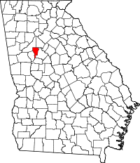 | |
| CDPs | ||
| Unincorporated communities | ||
| Footnotes | ‡This populated place also has portions in an adjacent county or counties | |
