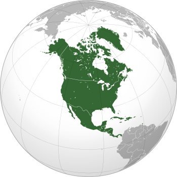
North America
 | |
| Area | 24,709,000 km2 (9,540,000 sq mi) |
|---|---|
| Population | 565,265,000 (2013, 4th) |
| Pop. density | 22.9/km2 (59.3/sq mi)[note 1] |
| GDP (nominal) | $20.3 trillion (2013, 2nd) |
| GDP (PPP) | $20.9 trillion (2013, 2nd) |
| Demonym | North American |
| Countries | 23 |
| Dependencies | 22 (see list of countries) |
| Languages | English, Spanish, French, and many others |
| Time zones | UTC-10 to UTC |
| Largest cities |
Largest urban areas:[1] Mexico City New York City Los Angeles Chicago Toronto Dallas–Fort Worth San Francisco Houston Miami Philadelphia |
North America is a continent entirely within the Northern Hemisphere and almost all within the Western Hemisphere. It can also be considered a northern subcontinent of the Americas.[2][3] It is bordered to the north by the Arctic Ocean, to the east by the Atlantic Ocean, to the west and south by the Pacific Ocean, and to the southeast by South America and the Caribbean Sea.
North America covers an area of about 24,709,000 square kilometers (9,540,000 square miles), about 16.5% of the earth's land area and about 4.8% of its total surface. North America is the third largest continent by area, following Asia and Africa,[4] and the fourth by population after Asia, Africa, and Europe.[5]
In 2013, its population was estimated at nearly 565 million people in 23 independent states, or about 7.5% of the world's population, if nearby islands (most notably the Caribbean) are included.
North America was reached by its first human populations during the last glacial period, via crossing the Bering land bridge. The so-called Paleo-Indian period is taken to have lasted until about 10,000 years ago (the beginning of the Archaic or Meso-Indian period). The Classic stage spans roughly the 6th to 13th centuries. The Pre-Columbian era ended with the arrival of European settlers during the Age of Discovery and the Early Modern period. Present-day cultural and ethnic patterns reflect different kind of interactions between European colonists, indigenous peoples, African slaves and their descendants. European influences are strongest in the northern parts of the continent while indigenous and African influences are relatively stronger in the south. Because of the history of colonialism, most North Americans speak English, Spanish or French and societies and states commonly reflect Western traditions.
Name

The Americas are usually accepted as having been named after the Italian explorer Amerigo Vespucci by the German cartographers Martin Waldseemüller and Matthias Ringmann.[6] Vespucci, who explored South America between 1497 and 1502, was the first European to suggest that the Americas were not the East Indies, but a different landmass previously unknown by Europeans. In 1507, Waldseemüller produced a world map, in which he placed the word "America" on the continent of South America, in the middle of what is today Brazil. He explained the rationale for the name in the accompanying book Cosmographiae Introductio:[7]
... ab Americo inventore ... quasi Americi terram sive Americam (from Americus the discoverer ... as if it were the land of Americus, thus America).
For Waldseemüller, no one should object to the naming of the land after its discoverer. He used the Latinized version of Vespucci's name (Americus Vespucius), but in its feminine form "America", following the examples of "Europa", "Asia" and "Africa".
Later, other mapmakers extended the name America to the northern continent, In 1538, Gerard Mercator used America on his map of the world for all the Western Hemisphere.[8]
Some argue that the convention is to use the surname for naming discoveries except in the case of royalty and so a derivation from "Amerigo Vespucci" could be problematic.[9] Ricardo Palma (1949) proposed a derivation from the "Amerrique" mountains of Central America—Vespucci was the first to discover South America and the Amerrique mountains of Central America, which connected his discoveries to those of Christopher Columbus.
Alfred E. Hudd proposed a theory in 1908 that the continents are named after a Welsh merchant named Richard Amerike from Bristol, who is believed to have financed John Cabot's voyage of discovery from England to Newfoundland in 1497. A minutely explored belief that has been advanced is that America was named for a Spanish sailor bearing the ancient Visigothic name of 'Amairick'. Another is that the name is rooted in a Native American language.[8]
Extent
The term North America maintains various definitions in accordance with location and context. In Canadian English, North America may be used to refer to the United States and Canada together.[10] Alternatively, usage sometimes includes Greenland[11][12][13] and Mexico (as in the North American Free Trade Agreement),[12][14][15][16][17] as well as offshore islands. The UN geoscheme for "North America" separates Mexico from the United States and Canada, placing it instead within its designated "Central America" region, while also treating the islands of the Caribbean separately from the US/Canada definition—the UN's "North America" definition still includes the Canadian Arctic Archipelago and Greenland together with the US/Canada continental definition, with both insular entities being tectonically on the North American plate.
In Iran, and several Romance-language cultures, the cognates of North America usually designate a subcontinent of the Americas comprising Canada, the United States, and Mexico, and often Greenland, Saint Pierre et Miquelon, and Bermuda.[18]
North America has been historically referred to by other names. Spanish North America (New Spain) was often referred to as Northern America, and this was the first official name given to Mexico.[19]
Regions
Geographically the North American continent has many regions and subregions. These include cultural, economic, and geographic regions. Economic regions included those formed by trade blocs, such as the North American Trade Agreement bloc and Central American Trade Agreement. Linguistically and culturally, the continent could be divided into Anglo-America and Latin America. Anglo-America includes most of Northern America, Belize, and Caribbean islands with English-speaking populations (though sub-national entities, such as Louisiana and Quebec, are Francophone in composition).
The southern North American continent is composed of two regions. These are Central America and the Caribbean.[20][21] The north of the continent maintains recognized regions as well. In contrast to the common definition of "North America", that which encompasses the whole continent, the term "North America" is also used to refer to Canada, Mexico, the United States, and Greenland.[11][12][13][14][22]
The term Northern America refers to the northern-most countries and territories of North America, Canada, the United States, Greenland, Bermuda, and St. Pierre and Miquelon.[23][24] Although rarely used, the term Middle America—not to be confused with the Midwestern United States—groups the regions of Central America, the Caribbean, and Mexico.[25]
The largest countries of the continent, Canada and the United States, also contain well-defined and recognized regions. In the case of Canada these are the British Columbia Coast, Canadian Prairies, Central Canada, Atlantic Canada, and Northern Canada. These regions also contain many subregions. In the case of the United States – and in accordance with the US Census Bureau definitions – these regions are: New England, Mid-Atlantic, East North Central States, West North Central States, South Atlantic States, East South Central States, West South Central States, Mountain States, and Pacific States. Regions shared between both nations included the Great Lakes Region. Megalopolises have also formed between both nations in the case of the Pacific Northwest and the Great Lakes Megaregion.
Countries, territories, and dependencies
History
Geologic history

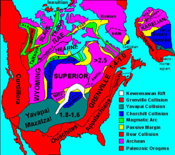
Laurentia is an ancient craton which forms the geologic core of North America; it formed between 1.5 and 1.0 billion years ago during the Proterozoic eon.[33] The Canadian Shield is the largest exposure of this craton. From the Late Paleozoic to Early Mesozoic eras, North America was joined with the other modern-day continents as part of the supercontinent Pangaea, with Eurasia to its east. One of the results of the formation of Pangaea was the Appalachian Mountains, which formed some 480 million years ago, making it among the oldest mountain ranges in the world. When Pangaea began to rift around 200 million years ago, North America became part of Laurasia, before it separated from Eurasia as its own continent during the mid-Cretaceous period.[34] The Rockies and other western mountain ranges began forming around this time from a period of mountain building called the Laramide orogeny, between 80 and 55 million years ago. The formation of the Isthmus of Panama that connected the continent to South America arguably occurred approximately 12 to 15 million years ago,[35] and the Great Lakes (as well as many other northern freshwater lakes and rivers) were carved by receding glaciers about 10,000 years ago.
North America is the source of much of what humanity knows about geologic time periods.[36] The geographic area that would later become the United States has been the source of more varieties of dinosaurs than any other modern country.[36] According to paleontologist Peter Dodson, this is primarily due to stratigraphy, climate and geography, human resources, and history.[36] Much of the Mesozoic Era is represented by exposed outcrops in the many arid regions of the continent.[36] The most significant Late Jurassic dinosaur-bearing fossil deposit in North America is the Morrison Formation of the western United States.[37]
Pre-Columbian

The indigenous peoples of North America have many creation myths by which they assert that they have been present on the land since its creation.[38] The specifics of Paleo-Indian migration to and throughout the Americas, including the exact dates and routes traveled, are subject to ongoing research and discussion.[39] The traditional theory has been that these early migrants moved into the Beringia land bridge between eastern Siberia and present-day Alaska around 25,000 to 11,000 years ago.[40] The few agreements achieved to date are the origin from Central Asia, with widespread habitation of the Americas during the end of the last glacial period, or more specifically what is known as the late glacial maximum, around 13,000 years before present.[41] Some genetic research indicated secondary waves of migration occurred after the initial Paleo-Indian colonization,[42] but prior to modern Inuit, Inupiat and Yupik expansions.[43]
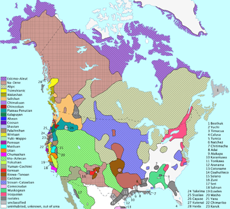
Before contact with Europeans, the natives of North America were divided into many different polities, from small bands of a few families to large empires. They lived in several "culture areas", which roughly correspond to geographic and biological zones and give a good indication of the main lifeway or occupation of the people who lived there (e.g., the bison hunters of the Great Plains, or the farmers of Mesoamerica). Native groups can also be classified by their language family (e.g., Athapascan or Uto-Aztecan). Peoples with similar languages did not always share the same material culture, nor were they always allies. Anthropologists think that the Inuit people of the high Arctic came to North America much later than other native groups, as evidenced by the disappearance of Dorset culture artifacts from the archaeological record, and their replacement by the Thule people.
During the thousands of years of native habitation on the continent, cultures changed and shifted. One of the oldest cultures yet found is the Clovis culture of modern New Mexico. Later cultures include the Mississippian culture and related Mound building cultures, found in the Mississippi river valley and the Pueblo culture of what is now the Four Corners. The more southern cultural groups of North America were responsible for the domestication of many common crops now used around the world, such as tomatoes and squash. Perhaps most importantly they domesticated one of the world's major staples, maize (corn).
The earliest verifiable instance of pre-Columbian trans-oceanic contact by any European culture with the landmasses that geologically constitute the "mainland" of modern North America has been dated to the end of the 10th century CE - this site, situated at the northernmost extent of the island named Newfoundland, is known as L'Anse aux Meadows, where unmistakable evidence of Norse settlement was uncovered in the early 1960s.[44]
As a result of the development of agriculture in the south, many important cultural advances were made there. For example, the Maya civilization developed a writing system, built huge pyramids and temples, had a complex calendar, and developed the concept of zero around 400 CE, a few hundred years after the Mesopotamians.[45] The Mayan culture was still present in southern Mexico and Guatemala when the Spanish explorers arrived, but political dominance in the area had shifted to the Aztec Empire whose capital city Tenochtitlan was located further north in the Valley of Mexico. The Aztecs were conquered in 1521 by Hernán Cortés.[46]

Colonial period
During the Age of Discovery, Europeans explored and staked claims to various parts of North America. Upon their arrival in the "New World", the Native American population declined substantially, because of violent conflicts with the invaders and the introduction of European diseases to which the Native Americans lacked immunity.[47] Native culture changed drastically and their affiliation with political and cultural groups also changed. Several linguistic groups died out, and others changed quite quickly. The names and cultures that Europeans recorded were not necessarily the same as the names they had used a few generations before, or the ones in use today.
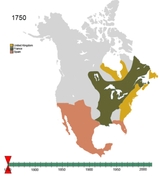
Britain, Spain, and France took over extensive territories in North America - and fought over them. In the late 18th century and beginning of the 19th, independence movements that sprung up across the continent, led to the creation of the modern countries in the area. The 13 British colonies on the North Atlantic coast declared independence in 1776, becoming the United States of America. Canada was formed from the unification of northern territories controlled by Britain and France. New Spain, a territory that stretched from modern-day southern US to Central America, declared independence in 1810, becoming the First Mexican Empire. In 1823 the former Captaincy General of Guatemala, then part of the Mexican Empire, became the first independent state in Central America, officially changing its name to the United Provinces of Central America.
Geography

North America occupies the northern portion of the landmass generally referred to as the New World, the Western Hemisphere, the Americas, or simply America (which, less commonly, is considered by some as a single continent[48][49][50] with North America a subcontinent).[51] North America's only land connection to South America is at the Isthmus of Panama. The continent is delimited on the southeast by most geographers at the Darién watershed along the Colombia-Panama border, placing all of Panama within North America.[52][53][54] Alternatively, some geologists physiographically locate its southern limit at the Isthmus of Tehuantepec, Mexico, with Central America extending southeastward to South America from this point.[55] The Caribbean islands, or West Indies, are considered part of North America.[2] The continental coastline is long and irregular. The Gulf of Mexico is the largest body of water indenting the continent, followed by Hudson Bay. Others include the Gulf of Saint Lawrence and the Gulf of California.
Before the Central American isthmus formed, the region had been underwater. The islands of the West Indies delineate a submerged former land bridge, which had connected North and South America via what are now Florida and Venezuela.
There are numerous islands off the continent's coasts; principally, the Arctic Archipelago, the Bahamas, Turks & Caicos, the Greater and Lesser Antilles, the Aleutian Islands (some of which are in the Eastern Hemisphere proper), the Alexander Archipelago, the many thousand islands of the British Columbia Coast, and Newfoundland. Greenland, a self-governing Danish island, and the world's largest, is on the same tectonic plate (the North American Plate) and is part of North America geographically. In a geologic sense, Bermuda is not part of the Americas, but an oceanic island which was formed on the fissure of the Mid-Atlantic Ridge over 100 million years ago. The nearest landmass to it is Cape Hatteras, North Carolina. However, Bermuda is often thought of as part of North America, especially given its historical, political and cultural ties to Virginia and other parts of the continent.

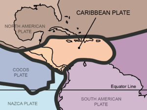
The vast majority of North America is on the North American Plate. Parts of western Mexico, including Baja California, and of California, including the cities of San Diego, Los Angeles, and Santa Cruz, lie on the eastern edge of the Pacific Plate, with the two plates meeting along the San Andreas fault. The southernmost portion of the continent and much of the West Indies lie on the Caribbean Plate, whereas the Juan de Fuca and Cocos plates border the North American Plate on its western frontier.
The continent can be divided into four great regions (each of which contains many subregions): the Great Plains stretching from the Gulf of Mexico to the Canadian Arctic; the geologically young, mountainous west, including the Rocky Mountains, the Great Basin, California and Alaska; the raised but relatively flat plateau of the Canadian Shield in the northeast; and the varied eastern region, which includes the Appalachian Mountains, the coastal plain along the Atlantic seaboard, and the Florida peninsula. Mexico, with its long plateaus and cordilleras, falls largely in the western region, although the eastern coastal plain does extend south along the Gulf.
The western mountains are split in the middle into the main range of the Rockies and the coast ranges in California, Oregon, Washington, and British Columbia, with the Great Basin—a lower area containing smaller ranges and low-lying deserts—in between. The highest peak is Denali in Alaska.
The United States Geographical Survey (USGS) states that the geographic center of North America is "6 miles [10 km] west of Balta, Pierce County, North Dakota" at about 48°10′N 100°10′W / 48.167°N 100.167°W, about 24 kilometres (15 mi) from Rugby, North Dakota. The USGS further states that "No marked or monumented point has been established by any government agency as the geographic center of either the 50 States, the conterminous United States, or the North American continent." Nonetheless, there is a 4.6-metre (15 ft) field stone obelisk in Rugby claiming to mark the center. The North American continental pole of inaccessibility is located 1,650 km (1,030 mi) from the nearest coastline, between Allen and Kyle, South Dakota at 43°22′N 101°58′W / 43.36°N 101.97°W.[56]
Geology


Canadian geology
Geologically, Canada is one of the oldest regions in the world, with more than half of the region consisting of precambrian rocks that have been above sea level since the beginning of the Palaeozoic era.[57] Canada's mineral resources are diverse and extensive.[57] Across the Canadian Shield and in the north there are large iron, nickel, zinc, copper, gold, lead, molybdenum, and uranium reserves. Large diamond concentrations have been recently developed in the Arctic,[58] making Canada one of the world's largest producers. Throughout the Shield there are many mining towns extracting these minerals. The largest, and best known, is Sudbury, Ontario. Sudbury is an exception to the normal process of forming minerals in the Shield since there is significant evidence that the Sudbury Basin is an ancient meteorite impact crater. The nearby, but less known Temagami Magnetic Anomaly has striking similarities to the Sudbury Basin. Its magnetic anomalies are very similar to the Sudbury Basin, and so it could be a second metal-rich impact crater.[59] The Shield is also covered by vast boreal forests that support an important logging industry.
US geological provinces
The lower 48 US states can be divided into roughly five physiographic provinces:
- The American cordillera.
- The Canadian Shield.[57] Northern portion of the upper midwestern United States.
- The stable platform.
- The coastal plain.
- The Appalachian orogenic belt.
The geology of Alaska is typical of that of the cordillera, while the major islands of Hawaii consist of Neogene volcanics erupted over a hot spot.

Central American geology
Central America is geologically active with volcanic eruptions and earthquakes occurring from time to time. In 1976 Guatemala was hit by a major earthquake, killing 23,000 people; Managua, the capital of Nicaragua, was devastated by earthquakes in 1931 and 1972, the last one killing about 5,000 people; three earthquakes devastated El Salvador, one in 1986 and two in 2001; one earthquake devastated northern and central Costa Rica in 2009, killing at least 34 people; in Honduras a powerful earthquake killed seven people in 2009.
Volcanic eruptions are common in the region. In 1968 the Arenal Volcano, in Costa Rica, erupted and killed 87 people. Fertile soils from weathered volcanic lavas have made it possible to sustain dense populations in the agriculturally productive highland areas.
Central America has many mountain ranges; the longest are the Sierra Madre de Chiapas, the Cordillera Isabelia, and the Cordillera de Talamanca. Between the mountain ranges lie fertile valleys that are suitable for the people; in fact, most of the population of Honduras, Costa Rica, and Guatemala live in valleys. Valleys are also suitable for the production of coffee, beans, and other crops.
Climate
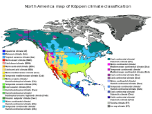
North America is a very large continent which surpasses the Arctic Circle, and the Tropic of Cancer. Greenland, along with the Canadian shield, is tundra with average temperatures ranging from between 10 to 20 °C (50 to 68 °F), but central Greenland is composed of a very large ice sheet. This tundra radiates throughout Canada, but its border ends near the Rocky Mountains (but still contains Alaska) and at the end of the Canadian Shield, near the Great Lakes. Climate west of the Cascades is described as being a temperate weather with average precipitation 20 inches (510 mm).[60] Climate in coastal California is described to be Mediterranean, with average temperatures in cities like San Francisco ranging from between 57 to 70 °F (14 to 21 °C) over the course of the year.[61]
Stretching from the East Coast to eastern North Dakota, and stretching down to Kansas, is the continental-humid climate featuring hard seasons, with a large amount of annual precipitation, with places like New York City averaging 50 inches (1,300 mm).[62] Starting at the southern border of the continental-humid climate and stretching to the Gulf of Mexico (whilst encompassing the eastern half of Texas) is the subtropical climate. This area has the wettest cities in the contiguous U.S. with annual precipitation reaching 67 inches (1,700 mm) in Mobile, Alabama.[63] Stretching from the borders of the continental humid and subtropical climates, and going west to the Cascades Sierra Nevada, south to the southern tip of durango, north to the border with tundra climate, the steppe/desert climate is the driest climate in the U.S.[64]
Demographics

Economically, Canada and the United States are the wealthiest and most developed nations in the continent, followed by Mexico, a newly industrialized country.[65] The countries of Central America and the Caribbean are at various levels of economic and human development. For example, small Caribbean island-nations, such as Barbados, Trinidad and Tobago, and Antigua and Barbuda, have a higher GDP (PPP) per capita than Mexico due to their smaller populations. Panama and Costa Rica have a significantly higher Human Development Index and GDP than the rest of the Central American nations.[66] Additionally, despite Greenland's vast resources in oil and minerals, much of them remain untapped, and the island is economically dependent on fishing, tourism, and subsidies from Denmark. Nevertheless, the island is highly developed.[67]
Demographically, North America is ethnically diverse. Its three main groups are Caucasians, Mestizos and Blacks. There is a significant minority of Indigenous Americans and Asians among other less numerous groups.
Languages
The dominant languages in North America are English, Spanish, and French. Danish is prevalent in Greenland alongside Greenlandic, and Dutch is spoken side by side local languages in the Dutch Caribbean. The term Anglo-America is used to refer to the anglophone countries of the Americas: namely Canada (where English and French are co-official) and the United States, but also sometimes Belize and parts of the tropics, especially the Commonwealth Caribbean. Latin America refers to the other areas of the Americas (generally south of the United States) where the Romance languages, derived from Latin, of Spanish and Portuguese (but French speaking countries are not usually included) predominate: the other republics of Central America (but not always Belize), part of the Caribbean (not the Dutch-, English-, or French-speaking areas), Mexico, and most of South America (except Guyana, Suriname, French Guiana (France), and the Falkland Islands (UK)).
The French language has historically played a significant role in North America and now retains a distinctive presence in some regions. Canada is officially bilingual. French is the official language of the Province of Quebec, where 95% of the people speak it as either their first or second language, and it is co-official with English in the Province of New Brunswick. Other French-speaking locales include the Province of Ontario (the official language is English, but there are an estimated 600,000 Franco-Ontarians), the Province of Manitoba (co-official as de jure with English), the French West Indies and Saint-Pierre et Miquelon, as well as the US state of Louisiana, where French is also an official language. Haiti is included with this group based on historical association but Haitians speak both Creole and French. Similarly, French and French Antillean Creole is spoken in Saint Lucia and the Commonwealth of Dominica alongside English.
Religions

Christianity is the largest religion in the United States, Canada and Mexico according to a 2012 Pew Research Center survey, 77.4% of the population considered themselves Christians.[68] Christianity also is the predominant religion in the 23 dependent territories in North America.[69] The United States has the largest Christian population in the world, with nearly 247 million Christians (70%), although other countries have higher percentages of Christians among their populations.[70] Mexico has the world's second largest number of Catholics, surpassed only by Brazil.[71]
According to the same study religiously unaffiliated (include agnostic and atheist) make up about 17.1% of the population of Canada and the United States.[72] No religion make up about 22.8% of the United States population, and 23.9% of Canada total population.[73]
Canada, the United States and Mexico host communities of both Jews (6 million or about 1.8%),[74] Buddhists (3.8 million or 1.1%)[75] and Muslims (3.4 million or 1.0%).[76] The biggest number of Jewish individuals can be found in the United States (5.4 million),[77] Canada (375,000)[78] and Mexico (67,476).[79] The United States host the largest Muslim population in North America with 2.7 million or 0.9%,[80][81] While Canada host about one million Muslim or 3.2% of the population.[82] While in Mexico there were 3,700 Muslims in the country.[83] In 2012, U-T San Diego estimated U.S. practitioners of Buddhism at 1.2 million people, of whom 40% are living in Southern California.[84]
The predominant religion in Central America is Christianity (95.6%).[85] Beginning with the Spanish colonization of Central America in the 16th century, Roman Catholicism became the most popular religion in the region until the first half of the 20th century. Since the 1960s, there has been an increase in other Christian groups, particularly Protestantism, as well as other religious organizations, and individuals identifying themselves as having no religion. Also Christianity is the predominant religion in the Caribbean (84.7%).[85] Other religious groups in the region are Hinduism, Islam, Rastafari (in Jamaica), and Afro-American religions such as Santería and Vodou.
Populace


The most populous country in North America, is the United States with 318.4 million persons.[86] The second largest country is Mexico with a population of 112,322,757.[87] Canada is the third most populous country with 32,623,490.[88] The majority of Caribbean island-nations have national populations under a million, though Cuba, Dominican Republic, Haiti, Puerto Rico (a territory of the United States), Jamaica, and Trinidad and Tobago each have populations higher than a million.[89][90][91][92][93] Despite Greenland's massive size (2,166,000 km² or 836,297 mi²), it has the world's lowest population density at 0.03 pop./km² (0.08 pop./mi²) for a small population of 55,984.[94]
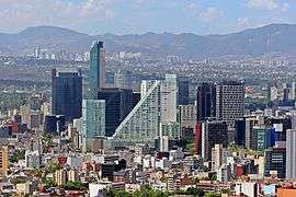
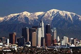
While the United States, Canada, and Mexico maintain the largest populations, large city populations are not restricted to those nations. There are also large cities in the Caribbean. The largest cities in North America, by far, are Mexico City and New York. These cities are the only cities on the continent to exceed eight million, and two of three in the Americas. Next in size are Los Angeles, Toronto,[95] Chicago, Havana, Santo Domingo, and Montreal. Cities in the sunbelt regions of the United States, such as those in Southern California and Houston, Phoenix, Miami, Atlanta, and Las Vegas, are experiencing rapid growth. These causes included warm temperatures, retirement of Baby Boomers, large industry, and the influx of immigrants. Cities near the United States border, particularly in Mexico, are also experiencing large amounts of growth. Most notable is Tijuana, a city bordering San Diego that receives immigrants from all over Latin America and parts of Europe and Asia. Yet as cities grow in these warmer regions of North America, they are increasingly forced to deal with the major issue of water shortages.[96]
Eight of the top ten metropolitan areas are located in the United States. These metropolitan areas all have a population of above 5.5 million and include the New York City metropolitan area, Los Angeles metropolitan area, Chicago metropolitan area, and the Dallas–Fort Worth metroplex.[97] Whilst the majority of the largest metropolitan areas are within the United States, Mexico is host to the largest metropolitan area by population in North America: Greater Mexico City.[98] Canada also breaks into the top ten largest metropolitan areas with the Toronto metropolitan area having six million citizens.[99] The proximity of cities to each other on the Canada–United States border and Mexico–United States border has led to the rise of international metropolitan areas. These urban agglomerations are observed at their largest and most productive in Detroit–Windsor and San Diego–Tijuana and experience large commercial, economic, and cultural activity. The metropolitan areas are responsible for millions of dollars of trade dependent on international freight. In Detroit-Windsor the Border Transportation Partnership study in 2004 concluded US$13 billion was dependent on the Detroit–Windsor international border crossing while in San Diego-Tijuana freight at the Otay Mesa Port of Entry was valued at US$20 billion.[100][101]
The North America continent has also been witness to the growth of megapolitan areas. In the United States exists eleven megaregions that transcend international borders and comprise Canadian and Mexican metropolitan regions. These are the Arizona Sun Corridor, Cascadia, Florida, Front Range, Great Lakes Megaregion, Gulf Coast Megaregion, Northeast, Northern California, Piedmont Atlantic, Southern California, and the Texas Triangle.[102] Canada and Mexico are also the home of megaregions. These include the Quebec City – Windsor Corridor, Golden Horseshoe – both of which are considered part of the Great Lakes Megaregion – and megalopolis of Central Mexico. Traditionally the largest megaregion has been considered the Boston-Washington, D.C. Corridor, or the Northeast, as the region is one massive contiguous area. Yet megaregion criterion have allowed the Great Lakes Megalopolis to maintain status as the most populated region, being home to 53,768,125 people in 2000.[103]
The top ten largest North American metropolitan areas by population as of 2013, based on national census numbers from the United States of America, and census estimates from Canada and Mexico.
| Metro Area | Population | Area | Country |
| Mexico City | 21,163,226† | 7,346 square kilometres (2,836 sq mi) | |
| New York City | 19,949,502 | 17,405 square kilometres (6,720 sq mi) | |
| Los Angeles | 13,131,431 | 12,562 square kilometres (4,850 sq mi) | |
| Chicago | 9,537,289 | 24,814 square kilometres (9,581 sq mi) | |
| Dallas–Fort Worth | 6,810,913 | 24,059 square kilometres (9,289 sq mi) | |
| Houston | 6,313,158 | 26,061 square kilometres (10,062 sq mi) | |
| Toronto | 6,054,191† | 5,906 square kilometres (2,280 sq mi) | |
| Philadelphia | 6,034,678 | 13,256 square kilometres (5,118 sq mi) | |
| Washington, D.C. | 5,949,859 | 14,412 square kilometres (5,565 sq mi) | |
| Miami | 5,828,191 | 15,896 square kilometres (6,137 sq mi) | |
†2011 Census figures.
Economy
| Rank | Country | GDP (PPP, 2014) millions of USD |
|---|---|---|
| 1 | 17,419,000 | |
| 2 | 2,148,884 | |
| 3 | 1,595,975 | |
| 4 | 234,193 | |
| 5 | 138,511 | |
| 6 | 125,630 | |
| 7 | 119,811 | |
| 8 | 80,811 | |
| 9 | 71,234 | |
| 10 | 51,193 |
| Rank | Country | GDP (nominal, 2014) millions of USD |
|---|---|---|
| 1 | 17,419,000 | |
| 2 | 1,786,655 | |
| 3 | 1,291,062 | |
| 4 | 103,135 | |
| 5 | 77,150 | |
| 6 | 64,058 | |
| 7 | 58,728 | |
| 8 | 49,553 | |
| 9 | 46,213 | |
| 10 | 28,874 |
Canada, Mexico and the United States have significant and multifaceted economic systems. The United States has the largest economy of all three countries and in the world.[104] In 2014, the US had an estimated per capita gross domestic product (PPP) of $54,980, and is the most technologically developed economy of the three.[104] The United States' services sector comprises 76.7% of the country's GDP (estimated in 2010), industry comprises 22.2% and agriculture comprises 1.2%.[104]
Canada shows significant growth in the sectors of services, mining and manufacturing.[105] Canada's per capita GDP (PPP) was estimated at $44,656 and it had the 11th largest GDP (nominal) in 2014.[105] Canada's services sector comprises 78% of the country's GDP (estimated in 2010), industry comprises 20% and agriculture comprises 2%.[105] Mexico has a per capita GDP (PPP) of $16,111 and as of 2014 is the 15th largest GDP (nominal) in the world.[106] Being a newly industrialized country,[65] Mexico maintains both modern and outdated industrial and agricultural facilities and operations.[107] Its main sources of income are oil, industrial exports, manufactured goods, electronics, heavy industry, automobiles, construction, food, banking and financial services.[108]
The North American economy is well defined and structured in three main economic areas.[109] These areas are the North American Free Trade Agreement (NAFTA), Caribbean Community and Common Market (CARICOM), and the Central American Common Market (CACM).[109] Of these trade blocs, the United States takes part in two. In addition to the larger trade blocs there is the Canada-Costa Rica Free Trade Agreement among numerous other free trade relations, often between the larger, more developed countries and Central American and Caribbean countries.
The North America Free Trade Agreement (NAFTA) forms one of the four largest trade blocs in the world.[110] Its implementation in 1994 was designed for economic homogenization with hopes of eliminating barriers of trade and foreign investment between Canada, the United States and Mexico.[111] While Canada and the United States already conducted the largest bilateral trade relationship – and to present day still do – in the world and Canada - United States trade relations already allowed trade without national taxes and tariffs,[112] NAFTA allowed Mexico to experience a similar duty-free trade. The free trade agreement allowed for the elimination of tariffs that had previously been in place on United States-Mexico trade. Trade volume has steadily increased annually and in 2010, surface trade between the three NAFTA nations reached an all-time historical increase of 24.3% or US$791 billion.[113] The NAFTA trade bloc GDP (PPP) is the world's largest with US$17.617 trillion.[114] This is in part attributed to the fact that the economy of the United States is the world's largest national economy; the country had a nominal GDP of approximately $14.7 trillion in 2010.[115] The countries of NAFTA are also some of each other's largest trade partners. The United States is the largest trade partner of Canada and Mexico;[116] while Canada and Mexico are each other's third largest trade partners.[117][118]
The Caribbean trade bloc – CARICOM – came into agreement in 1973 when it was signed by 15 Caribbean nations. As of 2000, CARICOM trade volume was US$96 billion. CARICOM also allowed for the creation of a common passport for associated nations. In the past decade the trade bloc focused largely on Free Trade Agreements and under the CARICOM Office of Trade Negotiations (OTN) free trade agreements have been signed into effect.
Integration of Central American economies occurred under the signing of the Central American Common Market agreement in 1961; this was the first attempt to engage the nations of this area into stronger financial cooperation. Recent implementation of the Central American Free Trade Agreement (CAFTA) has left the future of the CACM unclear.[119] The Central American Free Trade Agreement was signed by five Central American countries, the Dominican Republic, and the United States. The focal point of CAFTA is to create a free trade area similar to that of NAFTA. In addition to the United States, Canada also has relations in Central American trade blocs. Currently under proposal, the Canada – Central American Free Trade Agreement (CA4) would operate much the same as CAFTA with the United States does.
These nations also take part in inter-continental trade blocs. Mexico takes a part in the G3 Free Trade Agreement with Colombia and Venezuela and has a trade agreement with the EU. The United States has proposed and maintained trade agreements under the Transatlantic Free Trade Area between itself and the European Union; the US-Middle East Free Trade Area between numerous Middle Eastern nations and itself; and the Trans-Pacific Strategic Economic Partnership between Southeast Asian nations, Australia, and New Zealand.
Transport

The Pan-American Highway route in the Americas is the portion of a network of roads nearly 48,000 km (30,000 mi) in length which travels through the mainland nations. No definitive length of the Pan-American Highway exists because the US and Canadian governments have never officially defined any specific routes as being part of the Pan-American Highway, and Mexico officially has many branches connecting to the US border. However, the total length of the portion from Mexico to the northern extremity of the highway is roughly 26,000 km (16,000 mi).
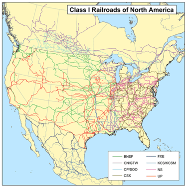
The First Transcontinental Railroad in the United States was built in the 1860s, linking the railroad network of the eastern US with California on the Pacific coast. Finished on 10 May 1869 at the famous Golden spike event at Promontory Summit, Utah, it created a nationwide mechanized transportation network that revolutionized the population and economy of the American West, catalyzing the transition from the wagon trains of previous decades to a modern transportation system.[120] Although an accomplishment, it achieved the status of first transcontinental railroad by connecting myriad eastern US railroads to the Pacific and was not the largest single railroad system in the world. The Canadian Grand Trunk Railway (GTR) had, by 1867, already accumulated more than 2,055 km (1,277 mi) of track by connecting Ontario with the Canadian Atlantic provinces west as far as Port Huron, Michigan, through Sarnia, Ontario.
Communications
A shared telephone system known as the North American Numbering Plan (NANP) which is an integrated telephone numbering plan of 24 countries and territories: the United States and its territories, Canada, Bermuda, and 17 Caribbean nations.
Culture
Canada and the United States were both former British colonies. There is frequent cultural interplay between the United States and English-speaking Canada. Greenland shares some cultural ties with the indigenous people of Canada but is considered Nordic and has strong Danish ties due to centuries of colonization by Denmark. Spanish-speaking North America shares a common past as former Spanish colonies. In Mexico and the Central American countries where civilizations like the Maya developed, indigenous people preserve traditions across modern boundaries. Central American and Spanish-speaking Caribbean nations have historically had more in common due to geographical proximity.
Northern Mexico, particularly in the cities of Monterrey, Tijuana, Ciudad Juárez, and Mexicali, is strongly influenced by the culture and way of life of the United States. Of the aforementioned cities, Monterrey has been regarded as the most Americanized city in North America.[121] Immigration to the United States and Canada remains a significant attribute of many nations close to the southern border of the US. The Anglophone Caribbean states have witnessed the decline of the British Empire and its influence on the region, and its replacement by the economic influence of Northern America. In the Anglophone Caribbean. This is partly due to the relatively small populations of the English-speaking Caribbean countries, and also because many of them now have more people living abroad than those remaining at home.
Sports
The following table shows the most prominent sports leagues in North America, in order of average revenue.[122][123]
| League | Sport | Primary country | Founded | Teams | Revenue US$ (bn) | Average Attendance |
|---|---|---|---|---|---|---|
| National Football League | American football | United States | 1920 | 32 | $9.0 | 67,604 |
| Major League Baseball | Baseball | United States Canada | 1869 | 30 | $8.0 | 30,458 |
| National Basketball Association | Basketball | United States Canada | 1946 | 30 | $5.0 | 17,347 |
| National Hockey League | Ice hockey | United States Canada | 1917 | 30 | $3.3 | 17,720 |
| Liga MX | Football (soccer) | Mexico | 1943 | 18 | $0.6[124] | 25,557 |
| Major League Soccer | Football (soccer) | United States Canada | 1994 | 20[o 1] | $0.5 | 21,574 |
- ↑ MLS plans to expand to 21 teams in 2017, and to 24 teams by 2020.
See also
- Americas (terminology)
- Geography of North America
- Geology of North America
- History of North America
- Nearctic ecozone
- Transportation in North America
Organizations and agreements:
- Caribbean Community
- Commission for Environmental Cooperation
- North American Aerospace Defense Command
- North American Agreement on Environmental Cooperation
- North American Free Trade Agreement
- North Atlantic Treaty Organization
- Organization of American States
- Trans-Pacific Partnership
Notes
- ↑ This North American density figure is based on a total land area of 23,090,542 km2 only, considerably less than the total combined land and water area of 24,709,000 km2.
- 1 2 3 4 5 Depending on definitions, Aruba, Bonaire, Curaçao, Panama, and Trinidad and Tobago have territory in either or both of North and South America.
- ↑ Since the Lucayan Archipelago is located in the Atlantic Ocean rather than Caribbean Sea, the Bahamas are part of the West Indies but are not technically part of the Caribbean, although the United Nations groups them with the Caribbean.
- ↑ Because of ongoing activity of the Soufriere Hills volcano beginning in July 1995, much of Plymouth was destroyed and government offices were relocated to Brades. Plymouth remains the de jure capital.
- ↑ Panama is generally considered a North American country, though some authorities divide it at the Panama Canal. Figures listed here are for the entire country.
- ↑ Since the Lucayan Archipelago is located in the Atlantic Ocean rather than Caribbean Sea, the Turks and Caicos Islands are part of the West Indies but are not technically part of the Caribbean, although the United Nations groups them with the Caribbean.
- ↑ Includes the US state of Hawaii, which is distant from the North American landmass in the Pacific Ocean and therefore more commonly associated with the other territories of Oceania.
References
- ↑ Demographia.com
- 1 2 "North America". Encyclopædia Britannica. Retrieved 3 February 2014.
- ↑ "Map And Details Of All 7 Continents". worldatlas.com. Retrieved September 2, 2016.
In some parts of the world students are taught that there are only six continents, as they combine North America and South America into one continent called the Americas.
- ↑ "North America Land Forms and Statistics". World Atlas.com. Retrieved 16 June 2013.
- ↑ "North America Fast Facts". World Atlas.com. Retrieved 16 June 2013.
- ↑ "Amerigo Vespucci". Encyclopædia Britannica. Retrieved 7 July 2011.
- ↑ Herbermann, Charles George, ed. (1907). The Cosmographiæ Introductio of Martin Waldseemüller in Facsimile. Translated by Edward Burke and Mario E. Cosenza, introduction by Joseph Fischer and Franz von Wieser. New York: The United States Catholic Historical Society. p. 9.
Latin: "Quarta pars per Americum Vesputium (ut in sequentibus audietur) inventa est, quam non video, cur quis jure vetet, ab Americo inventore sagacis ingenii viro Amerigen quasi Americi terram sive Americam dicendam, cum et Europa et Asia a mulieribus sua sortita sint nomina."
- 1 2 Jonathan Cohen. "The Naming of America: Fragments We've Shored Against Ourselves". Retrieved 3 February 2014.
- ↑ Lloyd, John; Mitchinson, John (2006). The Book of General Ignorance. Harmony Books. p. 95. ISBN 978-0-307-39491-0.
New countries or continents were never named after a person's first name, but always after the second ...
- ↑ Burchfield, R. W., ed. (2004). ""America"". Fowler's Modern English Usage. New York: Oxford University Press. p. 48. ISBN 0-19-861021-1.
the term 'North America' is mostly used to mean the United States and Canada together. Countries to the south of the United States are described as being in Central America (Mexico, Nicaragua, etc.) or South America (Brazil, Argentina, etc.).
See also: McArthur, Tom (1992). "North American". The Oxford Companion to the English Language. New York: Oxford University Press. p. 707. ISBN 0-19-214183-X. - 1 2 "CIA – The World Factbook – North America". Central Intelligence Agency. Retrieved 20 June 2011.
- 1 2 3 "Countries in North America – Country Reports". Country Reports. Archived from the original on 27 April 2015.
- 1 2 "North America: World of Earth Science". eNotes Inc. Archived from the original on 20 December 2010. Retrieved 20 June 2011.
- 1 2 "North American Region". The Trilateral Commission. Retrieved 30 May 2011.
- 1 2 "SPP Background". CommerceConnect.gov. Security and Prosperity Partnership Of North America. Archived from the original on 18 June 2008. Retrieved 14 November 2010.
- 1 2 "Ecoregions of North America". United States Environmental Protection Agency. Retrieved 30 May 2011.
- 1 2 "What's the difference between North, Latin, Central, Middle, South, Spanish and Anglo America?". About.com.
- ↑ "Norteamérica" [North America] (in Spanish). Archived from the original on 30 January 2009.
In Ibero-America, North America is considered a subcontinent containing Canada, the United States, Mexico, Greenland, Bermuda and Saint-Pierre and Miquelon.
- ↑ "Acta Solemne de la Declaración de Independencia de la América Septentrional" [Solemn Act of the Declaration of Independence of Northern America]. Archivos de la Independencia (in Spanish). Archivo General de la Nación. Retrieved 8 July 2011.
- ↑ Central America. Encarta Encyclopedia. Retrieved 30 May 2011.
- ↑ "Caribbean". The Free Dictionary. Retrieved 30 May 2011.
- ↑ Parsons, Alan; Schaffer, Jonathan (May 2004). Geopolitics of oil and natural gas. Economic Perspectives. U.S. Department of State.
- ↑ "Definition of major areas and regions". United Nations. Retrieved 3 October 2007.
- ↑ "Composition of macro geographical (continental) regions, geographical sub-regions, and selected economic and other groupings". UN Statistics Division. Retrieved 3 October 2007. (French)
- ↑ "Middle America (region, Mesoamerica)". Encyclopædia Britannica. Retrieved 20 June 2011.
- ↑ Unless otherwise noted, land area figures are taken from "Demographic Yearbook—Table 3: Population by sex, rate of population increase, surface area and density" (PDF). United Nations Statistics Division. 2008. Retrieved 14 October 2010.
- ↑ Unless otherwise noted, population estimates are taken from Department of Economic and Social Affairs Population Division (2009). "World Population Prospects, Table A.1" (PDF). 2008 revision. United Nations. Retrieved 12 March 2009.
- 1 2 3 4 5 Population estimates are taken from the Central Bureau of Statistics Netherlands Antilles. "Statistical information: Population". Government of the Netherlands Antilles. Archived from the original on 1 May 2010. Retrieved 14 October 2010.
- ↑ "Insee – Populations légales 2008 – 971-Guadeloupe" (in French). Insee.fr. Retrieved 31 October 2011.
- ↑ "Insee – Populations légales 2008 – 972-Martinique" (in French). Insee.fr. Retrieved 31 October 2011.
- 1 2 3 Land area figures taken from "The World Factbook: 2010 edition". Government of the United States, Central Intelligence Agency. Retrieved 14 October 2010.
- 1 2 3 These population estimates are for 2010, and are taken from "The World Factbook: 2010 edition". Government of the United States, Central Intelligence Agency. Retrieved 14 October 2010.
- ↑ Dalziel, I.W.D. (1992). "On the organization of American Plates in the Neoproterozoic and the breakout of Laurentia". GSA Today. 2 (11): 237–241.
- ↑ Merali, Zeeya; Skinner, Brian J. Visualizing Earth Science. Wiley. ISBN 978-0-470-41847-5.
- ↑ "Land Bridge Linking Americas Rose Earlier Than Thought". LiveScience.com.
- 1 2 3 4 Dodson, Peter (1997). "American Dinosaurs". In Currie, Phillip J.; Padian, Kevin. Encyclopedia of Dinosaurs. Academic Press. pp. 10–13.
- ↑ Weishampel, David B. (2004). Weishampel, David B.; Dodson, Peter; Halszka, Osmólska, eds. Dinosaur distribution (Late Jurassic, North America). The Dinosauria. Berkeley: University of California Press. pp. 543–545. ISBN 0-520-24209-2.
- ↑ Jeremiah Curtin (2014). Creation Myths of Primitive America. Jazzybee Verlag. p. 2. ISBN 978-3-8496-4454-3.
- ↑ Phillip M. White (2006). American Indian chronology: chronologies of the American mosaic. Greenwood Publishing Group. p. 1. ISBN 978-0-313-33820-5. Retrieved 29 November 2011.
- ↑ William Haviland; Harald Prins; Dana Walrath; Bunny McBride (2013). Anthropology: The Human Challenge. Cengage Learning. pp. 219, 220. ISBN 978-1-285-67758-3.
- ↑ Timothy R. Pauketat (23 February 2012). The Oxford Handbook of North American Archaeology. OUP USA. p. 96. ISBN 978-0-19-538011-8.
- ↑ Skoglund, P.; Mallick, S.; Bortolini, M. C.; Chennagiri, N.; Hünemeier, T.; Petzl-Erler, M. L.; Salzano, F. M.; Patterson, N.; Reich, D. (21 July 2015). "Genetic evidence for two founding populations of the Americas". Nature. doi:10.1038/nature14895.
- ↑ Peter Bellwood; Immanuel Ness (2014). The Global Prehistory of Human Migration. John Wiley & Sons. p. 194. ISBN 978-1-118-97059-1.
- ↑ H. Ingstad and A. Stine Ingstad, The Viking Discovery of America (2000), p. 141.
- ↑ Robert Kaplan (16 January 2007). "What is the origin of zero? How did we indicate nothingness before zero?". Scientific American. Retrieved 19 February 2008.
- ↑ Bernard Grunberg, "La folle aventure d'Hernan Cortés", in L'Histoire n°322, July–August 2007
- ↑ Massimo Livi Bacci, Malden (2001). A Concise History of World Population: An Introduction to Population Processes, (3rd ed.). Massachusetts: Blackwell Publishing. pp. 42–46. ISBN 0-631-22335-5.
- ↑ "The Olympic symbols" (PDF). Lausanne: Olympic Museum and Studies Centre: International Olympic Committee. 2002. Archived from the original (PDF) on 7 March 2008. The five rings of the Olympic flag represent the five inhabited, participating continents (Africa, America, Asia, Europe, and Oceania).
- ↑ "Continente". Océano Uno, Diccionario Enciclopédico y Atlas Mundial. pp. 392, 1730. ISBN 84-494-0188-7.
- ↑ Los Cinco Continentes (The Five Continents). Planeta-De Agostini Editions. 1997. ISBN 84-395-6054-0.
- ↑ "Encarta, "Norteamérica"" (in Spanish). Archived from the original on 31 October 2009.
- ↑ "Americas". Standard Country and Area Codes Classifications (M49). United Nations Statistics Division. Retrieved 3 February 2014.
- ↑ "North America". Atlas of Canada. Archived from the original on 21 October 2006.
- ↑ "North America Atlas". National Geographic.
- ↑ "Central America". Encyclopædia Britannica. Retrieved 28 June 2011.
- ↑ Garcia-Castellanos, D.; Lombardo, U. (2007). "Poles of Inaccessibility: A Calculation Algorithm for the Remotest Places on Earth" (PDF). Scottish Geographical Journal. 123 (3): 227–233. doi:10.1080/14702540801897809.
- 1 2 3 Wallace, Stewart W. (1948). Geology Of Canada. The Encyclopedia of Canada. III. Toronto: University Associates of Canada. pp. 23–26. Archived from the original on 4 July 2010. Retrieved 1 June 2011 – via Marianopolis College.
- ↑ "Digging for Diamonds 24/7 Under Frozen Snap Lake". Wired.com. Wired. Retrieved 1 June 2011.
- ↑ "3-D Magnetic Imaging using Conjugate Gradients: Temagami anomaly". Retrieved 13 March 2008.
- ↑ University of Washington. "Cascades weather". University of Washington.
- ↑ SF to do. "Temperature of San Francisco". tourism.
- ↑ Current Results. "Rainfall of NYC". Current Results.
- ↑ Andrea Thompson. "Top 10 wettest cities". livescience.
- ↑ Rita D. Haberlin (2015). "Climates Regions of North America". Peralta Colleges, Physical Geography. Archived from the original on 2 October 2015.
- 1 2 David Waugh (2000). "Manufacturing industries (chapter 19), World development (chapter 22)". Geography, An Integrated Approach (3rd ed.). Nelson Thornes Ltd. pp. 563, 576–579, 633, and 640. ISBN 0-17-444706-X.
- ↑ "2010 Human development Report" (PDF). United Nations Development Programme. pp. 148–151. Archived from the original (PDF) on 8 November 2010. Retrieved 6 May 2011.
- ↑ "Independence on ice". The Economist. 21 January 2015.
- ↑ The Global Religious Landscape A Report on the Size and Distribution of the World's Major Religious Groups as of 2010 Pew Forum on Religion & Public Life, p.18
- ↑ Global Christianity A Report on the Size and Distribution of the World's Christian Population Pew Forum on Religion & Public Life, p.15
- ↑ "America's Changing Religious Landscape". Pew Research Center: Religion & Public Life. 12 May 2015.
- ↑ "The Largest Catholic Communities". Adherents.com. Retrieved 10 November 2007.
- ↑ "Religiously Unaffiliated". Pew Research Center's Religion & Public Life Project. 18 December 2012. Retrieved 22 February 2015.
- ↑ "Religions in Canada—Census 2011". Statistics Canada/Statistique Canada.
- ↑ "THE GLOBAL RELIGIOUS LANDSCAPE: Jews". pewforum. Retrieved 18 December 2012.
- ↑ "THE GLOBAL RELIGIOUS LANDSCAPE: Buddhists". pewforum. Retrieved 18 December 2012.
- ↑ "THE GLOBAL RELIGIOUS LANDSCAPE: Muslims". pewforum. Retrieved 18 December 2012.
- ↑ World Jewish Population, 2012
- ↑ DellaPergola, Sergio (2013). Dashefsky, Arnold; Sheskin, Ira, eds. "World Jewish Population, 2013" (PDF). Current Jewish Population Reports. Storrs, Connecticut: North American Jewish Data Bank.
- ↑ "Panorama de las religiones en México 2010" (PDF) (in Spanish). INEGI. p. 3. Retrieved 2 March 2015.
- ↑ "America's Changing Religious Landscape". The Pew Forum on Religion & Public Life. Retrieved 12 May 2015.
- ↑ "Demographics". Retrieved 2 May 2013.
- ↑ "National Household Survey (NHS) Profile, 2011".
- ↑ Instituto Nacional de Estadística y Geografía (2010). "Censo de Población y Vivienda 2010 – Cuestionario básico". INEGI. Retrieved 4 March 2011.
- ↑ Rowe, Peter (16 April 2012). "Dalai Lama facts and figures". U-T San Diego. Retrieved 15 January 2015.
- 1 2 Christianity in its Global Context
- ↑ U.S. Census Bureau 1 July 2014. Retrieved 13 August 2014.
- ↑ "INEGI 2010 Census Statistics". inegi.org.mx. Retrieved 25 November 2010.
- ↑ "Estimated population of Canada, 1605 to present". Statistics Canada. 6 July 2009. Retrieved 23 May 2011.
- ↑ "Anuario Estadístico de Cuba 2009" (in Spanish) (2010 ed.). Oficina Nacional de Estadísticas, República de Cuba. Archived from Anuario Estadístico de Cuba 2009 the original Check
|url=value (help) on 16 July 2010. Retrieved 6 November 2010. Note: An exchange rate of 1 CUC to US$1.08 was used to convert GDP. - ↑ "Presidencia de la República; Generalidades" (in Spanish). Archived from the original on 22 November 2007. Retrieved 14 December 2009.
- ↑ "CIA – The World Factbook: Haiti". Central Intelligence Agency. Archived from the original on 3 March 2011. Retrieved 11 June 2011.
- ↑ "2010 U.S. Census Data". 2010.census.gov. Retrieved 6 February 2011.
- ↑ "CIA – The World Factbook: Jamaica". Central Intelligence Agency. Retrieved 11 June 2011.
- ↑ "Grønlands Statistik".
- ↑ "Toronto's population overtakes Chicago". Toronto Star. 5 March 2013.
- ↑ Cetron, Marvin J.; O'Toole, Thomas (April 1982). Encounters with the future: a forecast of life into the 21st century. Mcgraw-Hill. p. 34.
- ↑ "Population and Housing Occupancy Status: 2010 – United States – Metropolitan Statistical Area; and for Puerto Rico more information 2010 Census National Summary File of Redistricting Data". 2010 United States Census. United States Census Bureau, Population Division. 14 April 2011. Retrieved 14 April 2011.
- ↑ "CIA – The World Factbook: Mexico". Central Intelligence Agence. Retrieved 20 June 2011.
- ↑ Statistics Canada (2006). "Toronto, Ontario (Census metropolitan area)". Census 2006. Archived from the original on 14 January 2015. Retrieved 29 January 2010.
- ↑ "Detroit/Windsor Border Update: Part I-Detroit River International Crossing Study". Detroit Regional Chamber. 2006. Archived from the original on 21 March 2006.
- ↑ "Chapter IV Planning for the Future: Urban & Regional Planning in the San Diego-Tijuana Region" (PDF). International Community Foundation. Retrieved 20 March 2011.
- ↑ Hagler, Yoav (2009). "Defining U.S. Megaregions." New York, NY: Regional Plan Association.
- ↑ Regional Plan Association (2008). America 2050: An Infrastructure Vision for 21st Century America. New York, NY: Regional Plan Association.
- 1 2 3 "United States, Economy". U.S. Central Intelligence Agency. Retrieved 1 June 2011.
- 1 2 3 "Canada, Economy". U.S. Central Intelligence Agency. Retrieved 1 June 2011.
- ↑ "World Economic Outlook Database, October 2010". International Monetary Fund. Retrieved 5 March 2011.
- ↑ "Mexico, Economy". U.S. Central Intelligence Agency. Retrieved 1 June 2011.
- ↑ "Stratfor Global Market – Mexico". Stratfor. 30 August 2007. Retrieved 30 May 2010.
- 1 2 De la Torre, Miguel; Benavides, Benigno; Saldaña, José; Fernández, Jesús (2008). "Las profesiones en México: condiciones económicas, culturales y sociales". Sociología y Profesión [Sociology and Profession] (in Spanish). Monterrey: Nuevo León Autonomous University (UANL). p. 116. ISBN 970-24-0051-1.
La economía de América del Norte se encuentra bien definida y estructurada en tres principales áreas económicas: el Tratado de Libre Comercio de América del Norte (TLCAN), el CARICOM y el Mercado Común Centroamericano
- ↑ "Regional Trade Blocs". University of California, Santa Cruz. Retrieved 10 June 2011.
- ↑ North American Free Trade Agreement. Encyclopædia Britannica. Retrieved 10 June 2011.
- ↑ Fergusson, Ian. "CRS Report for Congress: United States-Canada Trade and Economic Relationship – Prospects and Challenges" (PDF). Congress Research Service. Retrieved 9 June 2011.
- ↑ "NAFTA Trade Volume Increases". Archived from the original on 8 August 2011.
- ↑ "2010 Report Countries by GDP (PPP)". International Monetary Fund. 14 September 2006. Retrieved 31 October 2011.
- ↑ "BEA News Release: Gross Domestic Product" (PDF) (Press release). Bureau of Economic Analysis. Retrieved 3 February 2014.
- ↑ "United States Foreign Trade Highlights". United States of America Bureau of the Census. Retrieved 3 February 2014.
- ↑ "Canadian Manufacturing Association". Retrieved 9 June 2011.
- ↑ "Mexico Free Trade Agreements" (PDF). Federation of American Scientists. Retrieved 9 June 2011.
- ↑ "Central American Community and Market". Pearson Education. Retrieved February 3, 2014.
- ↑ "Ceremony at "Wedding of the Rails", May 10, 1869 at Promontory Point, Utah". World Digital Library. 10 May 1869. Retrieved 20 July 2013.
- ↑ Emmot, Robert (1 June 2011). "Special report: If Monterrey falls Mexico falls – Reuters". Reuters.
- ↑ "The 'Big Five' in North American Pro Sports", FiveThrityEight, Nate Silver, 4 April 2014.
- ↑ "MLS vs the major leagues: can soccer compete when it comes to big business?", Guardian.com, 12 March 2014.
- ↑ "Premier League wages dwarf those around Europe", Daily Mail Online, 17 November 2014.
External links
- Houghton Mifflin Company, "North America"
- Interactive SVG version of Non-Native American Nations Control over N America 1750-2008 animation
| Sovereign states |
| | |||||||||||||||||
|---|---|---|---|---|---|---|---|---|---|---|---|---|---|---|---|---|---|---|---|
| Dependencies |
| ||||||||||||||||||
Continents of the world | ||||||
|---|---|---|---|---|---|---|
| ||||||
.svg.png)
.svg.png)
.svg.png)
.svg.png)
.svg.png)
.svg.png)
.svg.png)
.svg.png)
.svg.png)