Newbolds Corner, New Jersey
| Newbolds Corner, New Jersey | |
|---|---|
| Unincorporated community | |
|
Newbolds Corner from southbound Eayrestown Road (CR 612) | |
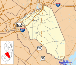 Newbolds Corner  Newbolds Corner  Newbolds Corner Location of Newbolds Corner in Burlington County (Inset: Location of county within the state of New Jersey) | |
| Coordinates: 39°57′47″N 74°46′47″W / 39.96306°N 74.77972°WCoordinates: 39°57′47″N 74°46′47″W / 39.96306°N 74.77972°W | |
| Country |
|
| State |
|
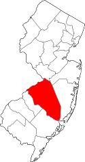
| County | Burlington |
| Township | Lumberton |
| Elevation[1] | 46 ft (14 m) |
| Time zone | Eastern (EST) (UTC-5) |
| • Summer (DST) | EDT (UTC-4) |
| GNIS feature ID | 878774[1] |

Newbolds Corner is an unincorporated community located within Lumberton Township in Burlington County, New Jersey, United States.[2] The site, located at the corner of Eayrestown Road (County Route 612) and Newbolds Corner Road, was once home to a Nike missile silo which was fully demolished in late 2015.[3][4][5] Today, the west side of Eayrestown Road consists of housing developments, Lumberton Township's town hall, and a school, while the east side of the road features farmland.[6]
References
- 1 2 "Newbolds Corner". Geographic Names Information System. United States Geological Survey.
- ↑ Locality Search, State of New Jersey. Accessed March 29, 2015.
- ↑ Bender, Donald E. "Nike Battery PH-23/25 - Lumberton, NJ". Nike Missiles & Missile Sites. Retrieved August 14, 2016.
- ↑ Bender, Donald E. (Fall 1999). "LUMBERTON'S COLD WAR LEGACY: NIKE MISSILE BATTERY PH-23/25". Nike Missiles & Missile Sites. Retrieved August 14, 2016.
- ↑ Hefler, Jan (July 19, 2015). "Lumberton finds new use for old Nike site". Philadelphia Inquirer. Retrieved August 14, 2016.
- ↑ Google (August 14, 2016). "Aerial view of Newbolds Corner" (Map). Google Maps. Google. Retrieved August 14, 2016.
This article is issued from Wikipedia - version of the 8/14/2016. The text is available under the Creative Commons Attribution/Share Alike but additional terms may apply for the media files.