Florence (CDP), New Jersey
| Florence, New Jersey | |
|---|---|
| Census-designated place | |
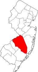
 Map of the former Florence-Roebling CDP in Burlington County. Inset: Location of Burlington County in New Jersey. | |
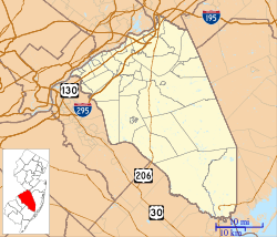 Florence, New Jersey  Florence, New Jersey  Florence, New Jersey Florence CDP's location in Burlington County (Inset: Location of Burlington County in New Jersey). | |
| Coordinates: 40°07′09″N 74°48′32″W / 40.119160°N 74.808773°WCoordinates: 40°07′09″N 74°48′32″W / 40.119160°N 74.808773°W | |
| Country |
|
| State |
|
| County | Burlington |
| Township | Florence |
| Area[1] | |
| • Total | 1.490 sq mi (3.857 km2) |
| • Land | 1.263 sq mi (3.270 km2) |
| • Water | 0.227 sq mi (0.587 km2) 15.23% |
| Elevation[2] | 23 ft (7 m) |
| Population (2010 Census)[3] | |
| • Total | 4,426 |
| • Density | 3,505.3/sq mi (1,353.4/km2) |
| Time zone | Eastern (EST) (UTC-5) |
| • Summer (DST) | Eastern (EDT) (UTC-4) |
| ZIP code | 08518[4] |
| Area code(s) | 609 |
| FIPS code | 3464350[1][5][6] |
| GNIS feature ID | 02652334[1][7] |
Florence is an unincorporated community and census-designated place (CDP) located within Florence Township, in Burlington County, New Jersey, United States,[8] that was established as part of the 2010 United States Census.[9][10][11] As of the 2000 United States Census, the CDP was combined as Florence-Roebling, which had a total population of 8,200.[12] As of the 2010 Census, the Florence-Roebling CDP was split into its components, Roebling (with a population of 3,715[13]) and Florence.[11] As of the 2010 Census, the population of the Florence CDP was 4,426.[3]
Geography
According to the United States Census Bureau, the CDP had a total area of 1.490 square miles (3.857 km2), including 1.263 square miles (3.270 km2) of land and 0.587 square miles (1.029 km2) of water (15.23%).[1][14]
Demographics
| Historical population | |||
|---|---|---|---|
| Census | Pop. | %± | |
| 2010 | 4,426 | — | |
| Population source: 2010[3] | |||
2010 Census
At the 2010 United States Census, there were 4,426 people, 1,857 households, and 1,166 families residing in the CDP. The population density was 3,505.3 per square mile (1,353.4/km2). There were 1,998 housing units at an average density of 1,582.4 per square mile (611.0/km2). The racial makeup of the CDP was 74.20% (3,284) White, 16.85% (746) Black or African American, 0.16% (7) Native American, 2.87% (127) Asian, 0.05% (2) Pacific Islander, 1.63% (72) from other races, and 4.25% (188) from two or more races. Hispanics or Latinos of any race were 5.24% (232) of the population.[3]
There were 1,857 households, of which 24.9% had children under the age of 18 living with them, 42.1% were married couples living together, 16.0% had a female householder with no husband present, and 37.2% were non-families. 31.4% of all households were made up of individuals, and 11.0% had someone living alone who was 65 years of age or older. The average household size was 2.38 and the average family size was 3.00.[3]
In the CDP, 21.0% of the population were under the age of 18, 8.4% from 18 to 24, 25.8% from 25 to 44, 31.2% from 45 to 64, and 13.6% who were 65 years of age or older. The median age was 41.3 years. For every 100 females there were 90.4 males. For every 100 females age 18 and over, there were 88.7 males.[3]
Transportation
The River Line offers service to Camden and Trenton Rail Station, with stations in Roebling at Hornberger Avenue and Florence at U.S. Route 130.[15]
New Jersey Transit provides service to and from Philadelphia on the 409.[16]
References
- 1 2 3 4 Gazetteer of New Jersey Places, United States Census Bureau. Accessed July 21, 2016.
- ↑ U.S. Geological Survey Geographic Names Information System: Florence Census Designated Place, Geographic Names Information System. Accessed June 27, 2012.
- 1 2 3 4 5 6 DP-1 - Profile of General Population and Housing Characteristics: 2010 Demographic Profile Data for Florence CDP, New Jersey, United States Census Bureau. Accessed June 27, 2012.
- ↑ Look Up a ZIP Code for Florence, NJ, United States Postal Service. Accessed June 27, 2012.
- ↑ American FactFinder, United States Census Bureau. Accessed September 4, 2014.
- ↑ A Cure for the Common Codes: New Jersey, Missouri Census Data Center. Accessed June 27, 2012.
- ↑ US Board on Geographic Names, United States Geological Survey. Accessed September 4, 2014.
- ↑ Locality Search, State of New Jersey. Accessed April 18, 2015.
- ↑ GCT-PH1 - Population, Housing Units, Area, and Density: 2010 - County -- County Subdivision and Place from the 2010 Census Summary File 1 for Burlington County, New Jersey, United States Census Bureau. Accessed June 17, 2013.
- ↑ 2006-2010 American Community Survey Geography for New Jersey, United States Census Bureau. Accessed June 17, 2013.
- 1 2 New Jersey: 2010 - Population and Housing Unit Counts - 2010 Census of Population and Housing (CPH-2-32), United States Census Bureau, p. III-3, August 2012. Accessed June 17, 2013. "Burlington County — Annexations from MCDs: Medford Lakes borough from Medford township; New CDPs: Florence (formed from part of deleted Florence-Roebling CDP), Juliustown (formed from part of Fort Dix CDP and additional area), and Roebling (formed from part of deleted Florence-Roebling CDP); Deleted CDPs: Florence-Roebling (split to form Florence and Roebling CDPs)"
- ↑ DP-1 - Profile of General Demographic Characteristics: 2000 from Census 2000 Summary File 1 (SF 1) 100-Percent Data for Florence-Roebling CDP, New Jersey, United States Census Bureau. Accessed June 17, 2013.
- ↑ DP-1 - Profile of General Population and Housing Characteristics: 2010 Demographic Profile Data for Roebling CDP, New Jersey, United States Census Bureau. Accessed June 17, 2013.
- ↑ US Gazetteer files: 2010, 2000, and 1990, United States Census Bureau. Accessed September 4, 2014.
- ↑ River LINE System Map, New Jersey Transit. Accessed July 21, 2016.
- ↑ Burlington County Bus / Rail Connections, New Jersey Transit, backed up by the Internet Archive as of June 26, 2010. Accessed June 17, 2013.