Havran, Balıkesir
For other uses, see Havran (disambiguation).
| Havran | |
|---|---|
| District | |
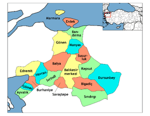 Location of Havran within Turkey. | |
 Havran Location of Havran | |
| Coordinates: 39°33′N 27°06′E / 39.550°N 27.100°E | |
| Country |
|
| Region | Aegean |
| Province | Balıkesir |
| Government | |
| • Mayor | Emin Ersoy (AKP). |
| Area[1] | |
| • District | 543.21 km2 (209.73 sq mi) |
| Elevation | 44 m (144 ft) |
| Population (2012)[2] | |
| • Urban | 11,001 |
| • District | 28,060 |
| • District density | 52/km2 (130/sq mi) |
| Time zone | EET (UTC+2) |
| • Summer (DST) | EEST (UTC+3) |
| Postal code | 10xxx |
| Area code(s) | 266 |
| Licence plate | 10 |
| Website | www.havran.bel.tr |
Havran is a town and county of Balıkesir Province in the Marmara region of Turkey. According to the 2010 census, the population of the county is 28,050 of which 10,766 live in the town of Havran.[3][4]
The county covers an area of 543 km2 (210 sq mi),[5] and the town lies at an elevation of 44 m (144 ft).
The county has traditionally produced Cheese and a fruit drink called Şerbet. Until the 1920 the population was mix of Turkish, Greek, and Tatar (refugees) with small numbers of Jews and Armenians.[6]
Notes
- ↑ "Area of regions (including lakes), km²". Regional Statistics Database. Turkish Statistical Institute. 2002. Retrieved 2013-03-05.
- ↑ "Population of province/district centers and towns/villages by districts - 2012". Address Based Population Registration System (ABPRS) Database. Turkish Statistical Institute. Retrieved 2013-02-27.
- ↑ Statistical Institute
- ↑ GeoHive. "Statistical information on Turkey's administrative units". Retrieved 2009-04-11.
- ↑ Statoids. "Statistical information on districts of Turkey". Retrieved 2009-04-04.
- ↑ Adramytti at Εγκυκλοπαίδεια Μείζονος Ελληνισμού.
References
- Falling Rain Genomics, Inc. "Geographical information on Havran, Turkey". Retrieved 2009-04-11.
External links
- District governor's official website (Turkish)
- Another road map of Havran and environs
- Various images of Havran
Coordinates: 39°33′30″N 27°05′54″E / 39.55833°N 27.09833°E
This article is issued from Wikipedia - version of the 2/12/2016. The text is available under the Creative Commons Attribution/Share Alike but additional terms may apply for the media files.