Gadchiroli district
| Gadchiroli district गडचिरोली जिल्हा | |
|---|---|
| District of Maharashtra | |
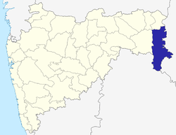 Location of Gadchiroli district in Maharashtra | |
| Country | India |
| State | Maharashtra |
| Administrative division | Nagpur Division |
| Headquarters | Gadchiroli |
| Tehsils |
|
| Government | |
| • Lok Sabha constituencies | 1. Gadchiroli-Chimur (shared with Chandrapur district) (Based on Election Commission website) |
| Area | |
| • Total | 14,412 km2 (5,565 sq mi) |
| Population (2001) | |
| • Total | 9,70,294 |
| • Density | 67/km2 (170/sq mi) |
| • Urban | 6.93% |
| Demographics | |
| • Literacy | 60.1% |
| • Sex ratio | 976 |
| Major highways | NH-16 |
| Average annual precipitation | 1,704 mm |
| Website | Official website |
Gadchiroli district (Marathi: गडचिरोली जिल्हा) is an administrative district in Maharashtra, India. The town of Gadchiroli is the administrative headquarters of the district.
Gadchiroli District is situated in the southeastern corner of Maharashtra, and is bounded by Chandrapur District to the west, Gondia District to the north, Chhattisgarh state to the east, and Telangana state to the south and southwest. Gadchiroli District was created on August 26, 1982 by the separation of Gadchiroli and Sironcha tehsils from Chandrapur District. As of 2011 it is the second least populous district of Maharashtra (out of 39), after Sindhudurg.[1]
The district is currently a part of the Red Corridor.[2]
Geography
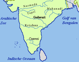
The main river basin of the district is the Godavari, which flows west to east and forms the southern boundary of the district. The major tributaries of the Godavari are the Indravati and the Pranhita, which is in turn formed by the confluence of the Wainganga and the Wardha near Chaprala village of Chamorshi Taluka.
Dhanora, Etapalli, Aheri and Sironcha talukas in the eastern part of the district are covered by forest. Hills are found in Bhamragad, Tipagad, Palasgad and Surjagad area. The western part of Gadchiroli is mainly hilly area.
Schools and colleges
The government has recently established Gondwana University in Gadhchiroli district.[3]
High Schools
- Shriniwas High School Ankisa
- Dharmarao High School Sironcha
- School Of Scholars, Gadchiroli
- Rampuri Primary School
- Shri. Shivaji High School,Gadchiroli
- Z.P. High School,Gadchiroli
- Carmel High School,Gadchiroli
- Platinum Jubilee High School
- Vasant Vidyalaya high School
- Rani Durgavati High School & Junior College
- Netaji Subhash Chandra Jr. College, Sundernagar
- Indira Gandhi Memoriyal High School & Junior college SUBHASHGRAM
Junior colleges
- Platinum Juiblee School & Jr. college
- Shriniwas Junior college Ankisa
- Z. P. Junior College of Science Sironcha
- Shivaji Junior Science College
- Govt ITI complex Gadchiroli
Senior (Degree) colleges
- Bhagvantrao Arts College Sironcha
- Shivaji Science college Gadchiroli
- Mahila Mahavidyalaya, gadchiroli
- Government Science College, Gadchiroli
- Government Polytechnic, Gadchiroli
- Government Agriculture College, Sonapur complex Gadchiroli
- Model College Gadchiroli
- Namdeorao Poreddiwar College Of Engineering And Technology [[4]]
Demographics
According to the 2011 census Gadchiroli district has a population of 1,071,795,[1] roughly equal to the nation of Cyprus[5] or the US state of Rhode Island.[6] This gives it a ranking of 424th in India (out of a total of 640).[1] The district has a population density of 74 inhabitants per square kilometre (190/sq mi).[1] Its population growth rate over the decade 2001–2011 was 10.46%.[1] Gadchiroli has a sex ratio of 975 females for every 1000 males,[1] and a literacy rate of 70.55%.[1]
Scheduled caste and scheduled tribe population in the district is 1,08,824 and 3,71,696. The tribal community population that resides in the district is 38.3%.[7] Seven languages are spoken in the district, namely, Gondi, Madiya, Marathi, Hindi, Telugu, Bengali, Chhattisgarhi.
Places of interest
- Wadadham Fossil Park
Waddham, a reserve forest, is a well-known fossils site where a full-fledged skeleton of a dinosaur was found near the Godavari basin bordering Telangana in 1959. The fossil has been kept in a Kolkata museum since then. "Waddham is an area in the proximity of Pranhita and Godavari rivers near Sironcha. This area, including parts of Telangana, has yielded some of the best known dinosaur fossils in India, and probably is the only locality of oldest dinosaurs (Triassic, 220 million years ago). Paleolithic (Stone Age) tools have been discovered in Maharashtra's first fossil park at Waddham in the Sironcha forest division of Gadchiroli district.
Fossils of the rhynchosaur, a dinosaur that lived around 200 million years ago, have been discovered in the region earlier.
Economy
The district is categoried as a tribal and undeveloped district and most of the land is covered with forest and hills. Forests cover more than 79.36% of the geographical area of the district. This district is famous for bamboo and Tendu leaves. Paddy is the main agricultural product of the district. The agriculture products of the district are sorghum, Linseed, pigeonpea(Tur), and wheat. The Main profession of the people is farming.
There is no large scale Industry in the district except the paper mill at Ashti in Chamorshi Taluka, and the paper pulp factory at Desaiganj. There are many rice mills in the district. The Tussar silk worm centre is in Armori Taluka. Only, 18.5 kilometers of railway lines pass through the district.
The district is well known for Naxalite activities; Naxalites from the People's Liberation Guerrilla Army have taken shelter in the dense forests and hills of this district.
In 2006 the Ministry of Panchayati Raj named Gadchiroli one of the country's 250 most backward districts (out of a total of 640).[8] It is one of the twelve districts in Maharashtra currently receiving funds from the Backward Regions Grant Fund Programme (BRGF).[8]
Divisions
The district is divided into three sub-divisions, Gadchiroli, Aheri and Desaiganj which are further divided into 12 talukas. Each sub-division has four talukas. Gadchiroli sub-division consists Gadchiroli, Dhanora, Chamorshi and Mulchera talukas, Aheri sub-division consists Aheri, Sironcha, Etapalli and Bhamragad talukas and Desaiganj (Wadsa) sub-division consists Wadsa, Armori, Kurkheda and Korchi talukas. There are 467 Gram Panchayats and 1688 Revenue Villages. The district has 12 Panchayat Samitis. Only two municipalities, Gadchiroli and Wadsa (Desaiganj) exist in the district.
Presently, after the delimitation of the constituencies in 2008, the district has three Vidhan Sabha (legislative assembly) constituencies, Gadchiroli, Armori and Aheri. All of these are part of the newly carved Gadchiroli-Chimur Lok Sabha constituency.[9]
Health and Education
The Lok Biradari Prakalpa (LBP) situated at Hemalkasa in the Bhamragad taluka is one of the major institutions offering healthcare and education services to the local Madia - Gond tribals. LBP was envisioned by the great Gandhian, late Dr. Murlidhar Devidas Amte, fondly called as Baba Amte. His family consisting of Dr. Prakash Amte, Dr. Mandakini Amte and their children currently work at the LBP.[10]
See also
References
- 1 2 3 4 5 6 7 "District Census 2011". Census2011.co.in. 2011. Retrieved 2011-09-30.
- ↑ "83 districts under the Security Related Expenditure Scheme". IntelliBriefs. 2009-12-11. Retrieved 2011-09-17.
- ↑
- ↑ NAMDEORAO POREDDIWAR COLLEGE OF ENGINEERING AND TECHNOLOGY GADCHIROLI
- ↑ US Directorate of Intelligence. "Country Comparison:Population". Retrieved 2011-10-01.
Cyprus 1,120,489 July 2011 est.
- ↑ "2010 Resident Population Data". U. S. Census Bureau. Retrieved 2011-09-30.
Rhode Island 1,052,567
- ↑
- 1 2 Ministry of Panchayati Raj (September 8, 2009). "A Note on the Backward Regions Grant Fund Programme" (PDF). National Institute of Rural Development. Retrieved September 27, 2011.
- ↑ "District wise List of Assembly and Parliamentary Constituencies". Chief Electoral Officer, Maharashtra website.
- ↑ People's Brotherhood Project. Lok Biradari Prakalp. Retrieved on 2016-07-31.
External links

| Topics | |||||||||||||||||||||||
|---|---|---|---|---|---|---|---|---|---|---|---|---|---|---|---|---|---|---|---|---|---|---|---|
| Regions | |||||||||||||||||||||||
| Divisions and Districts |
| ||||||||||||||||||||||
| Million-plus cities in Maharashtra | |||||||||||||||||||||||
| Other cities with municipal corporations | |||||||||||||||||||||||
Portal: Maharashtra | |||||||||||||||||||||||
| Rivers |
|    | |||||||||||||||||||||||||
|---|---|---|---|---|---|---|---|---|---|---|---|---|---|---|---|---|---|---|---|---|---|---|---|---|---|---|---|
| Dams, barrages | |||||||||||||||||||||||||||
| Geographical features / regions | |||||||||||||||||||||||||||
| Riparian districts |
| ||||||||||||||||||||||||||
| Cities | |||||||||||||||||||||||||||
| Languages / people | |||||||||||||||||||||||||||
| Coalfields | |||||||||||||||||||||||||||
| Oil / gas fields | |||||||||||||||||||||||||||
| Industries |
| ||||||||||||||||||||||||||
| Transport | |||||||||||||||||||||||||||
| Related topics | |||||||||||||||||||||||||||
| Other basins | |||||||||||||||||||||||||||
Coordinates: 20°11′10″N 80°00′19″E / 20.18611°N 80.00528°E
