Cottonwood, Apache County, Arizona
This article is about the census-designated place in Apache County, Arizona. For the city in Yavapai County, Arizona, see Cottonwood, Arizona.
| Cottonwood, Arizona | |
|---|---|
| Census-designated place | |
 Cottonwood | |
| Coordinates: 36°04′23″N 109°53′32″W / 36.07306°N 109.89222°WCoordinates: 36°04′23″N 109°53′32″W / 36.07306°N 109.89222°W | |
| Country | United States |
| State | Arizona |
| County | Apache |
| Area | |
| • Total | 0.14 sq mi (0.37 km2) |
| • Land | 0.14 sq mi (0.37 km2) |
| • Water | 0.0 sq mi (0.0 km2) |
| Elevation | 6,069 ft (1,850 m) |
| Population (2010) | |
| • Total | 226 |
| • Density | 1,578/sq mi (609.4/km2) |
| Time zone | MST (UTC-7) |
| • Summer (DST) | MDT (UTC-6) |
| FIPS code | 04-16360 |
| GNIS feature ID | 0003304 |
Cottonwood is a census-designated place (CDP) in Apache County, Arizona, United States. The population was 226 at the 2010 census.[1]
Geography
Cottonwood is located at 36°04′23″N 109°53′32″W / 36.07306°N 109.89222°W,[2] about 21 miles (34 km) west of Chinle and 22 miles (35 km) east of Pinon.
According to the United States Census Bureau, the CDP has a total area of 0.14 square miles (0.37 km2), all land.[1]
References
- 1 2 "Geographic Identifiers: 2010 Demographic Profile Data (G001): Cottonwood CDP, Arizona". U.S. Census Bureau, American Factfinder. Retrieved April 18, 2013.
- ↑ "US Gazetteer files: 2010, 2000, and 1990". United States Census Bureau. 2011-02-12. Retrieved 2011-04-23.
Municipalities and communities of Apache County, Arizona, United States | ||
|---|---|---|
| City | 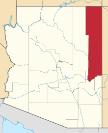 | |
| Towns | ||
| CDPs |
| |
| Unincorporated communities |
| |
| Indian reservations | ||
| Footnotes | ‡This populated place also has portions in an adjacent county or counties | |
This article is issued from Wikipedia - version of the 7/28/2014. The text is available under the Creative Commons Attribution/Share Alike but additional terms may apply for the media files.