Houck, Arizona
| Houck, Arizona | |
|---|---|
| Census-designated place | |
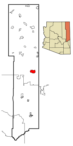 Location in Apache County and the state of Arizona | |
 Houck, Arizona Location in the United States | |
| Coordinates: 35°17′1″N 109°14′16″W / 35.28361°N 109.23778°WCoordinates: 35°17′1″N 109°14′16″W / 35.28361°N 109.23778°W | |
| Country | United States |
| State | Arizona |
| County | Apache |
| Government | |
| • Type | Navajo Chapter Government |
| • Houck Chapter President | Charles Morrison |
| Area | |
| • Total | 42.5 sq mi (110.0 km2) |
| • Land | 42.5 sq mi (110.0 km2) |
| • Water | 0.02 sq mi (0.06 km2) |
| Elevation | 6,035 ft (1,839 m) |
| Population (2010) | |
| • Total | 1,024 |
| • Density | 24/sq mi (9.3/km2) |
| Time zone | MST (UTC-7) |
| ZIP codes | 86506, 86508 |
| Area code | 928 |
| FIPS code | 04-33980 |
| GNIS feature ID | 0024465 |
Houck (Navajo: Maʼiitoʼí) is a census-designated place (CDP) in Apache County, Arizona, United States. The population was 1,024 at the 2010 census.[1]
Geography
Houck is located at 35°17′1″N 109°14′16″W / 35.28361°N 109.23778°W (35.283615, -109.237695).[2]
According to the United States Census Bureau, the CDP has a total area of 42.5 square miles (110.0 km2), of which 0.023 square miles (0.06 km2), or 0.05%, is water.[1]
Climate
According to the Köppen Climate Classification system, Houck has a semi-arid climate, abbreviated "BSk" on climate maps.[3]
History
Houck was founded by a mail carrier working a route from Prescott, Arizona, to Fort Wingate. In 1877, he established a trading post called Houck's Tank here. In 1880, William Walker and William Smith were murdered by Native Americans here. In 1885, Houck left.[4]
Demographics
As of the census[5] of 2000, there were 1,087 people, 312 households, and 234 families residing in the CDP. The population density was 25.7 people per square mile (9.9/km²). There were 414 housing units at an average density of 9.8/sq mi (3.8/km²). The racial makeup of the CDP was 95.58% Native American, 2.21% White, 0.09% Black or African American, 0.09% Asian, and 2.02% from two or more races. 1.01% of the population were Hispanic or Latino of any race.
There were 312 households out of which 47.1% had children under the age of 18 living with them, 37.8% were married couples living together, 28.2% had a female householder with no husband present, and 25.0% were non-families. 22.4% of all households were made up of individuals and 5.1% had someone living alone who was 65 years of age or older. The average household size was 3.48 and the average family size was 4.19.
In the CDP the age distribution of the population shows 42.2% under the age of 18, 7.3% from 18 to 24, 24.9% from 25 to 44, 19.1% from 45 to 64, and 6.4% who were 65 years of age or older. The median age was 26 years. For every 100 females there were 94.1 males. For every 100 females age 18 and over, there were 92.6 males.
The median income for a household in the CDP was $12,353, and the median income for a family was $20,208. Males had a median income of $18,750 versus $22,788 for females. The per capita income for the CDP was $5,219. About 53.8% of families and 53.5% of the population were below the poverty line, including 55.7% of those under age 18 and 51.4% of those age 65 or over.
Education
The area is served by Sanders Unified School District.
The area is served by Sanders Elementary School, Sanders Middle School, and Valley High School.
References
- 1 2 "Geographic Identifiers: 2010 Demographic Profile Data (G001): Houck CDP, Arizona". U.S. Census Bureau, American Factfinder. Retrieved April 19, 2013.
- ↑ "US Gazetteer files: 2010, 2000, and 1990". United States Census Bureau. 2011-02-12. Retrieved 2011-04-23.
- ↑ Climate Summary for Houck, Arizona
- ↑ Byrd H. Granger (1960). Arizona Place Names. University of Arizona Press. p. 13. Retrieved 5 December 2011.
- ↑ "American FactFinder". United States Census Bureau. Retrieved 2008-01-31.
Municipalities and communities of Apache County, Arizona, United States | ||
|---|---|---|
| City | 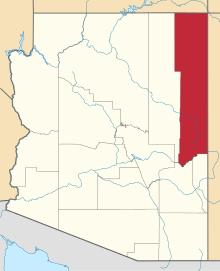 | |
| Towns | ||
| CDPs |
| |
| Unincorporated communities |
| |
| Indian reservations | ||
| Footnotes | ‡This populated place also has portions in an adjacent county or counties | |