Brownsville, Brooklyn
| Brownsville | |
|---|---|
| Neighborhood of Brooklyn | |
|
The Samuel J. Tilden Houses, one of many NYCHA public housing developments located in Brownsville | |
| Coordinates: 40°39′48″N 73°54′42″W / 40.66333°N 73.91167°WCoordinates: 40°39′48″N 73°54′42″W / 40.66333°N 73.91167°W | |
| Country |
|
| State |
|
| City | New York City |
| Borough | Brooklyn |
| Parceled | 1858 |
| Settled | 1861 |
| Founded by | William Suydam |
| Named for | Charles S. Brown |
| Area[1] | |
| • Total | 3.01 km2 (1.163 sq mi) |
| Population (2010)[2] | |
| • Total | 58,300 |
| • Density | 19,000/km2 (50,000/sq mi) |
| Economics | |
| • Median income | $31,252 |
| Ethnicity | |
| • White | 2.6% |
| • African American | 76.7% |
| • Hispanic American | 17.0% |
| • Asian/Pacific Islander | 1.0% |
| • Other | 3.7% |
| ZIP codes | 11212, 11233 |
| Area code | 917, 718, 347 |

Brownsville is a residential neighborhood located in eastern Brooklyn in New York City. The 1.163-square-mile (3.01 km2) area that comprises Brownsville has 58,300 residents as of the 2010 United States Census. Part of Brooklyn Community Board 16, Brownsville is generally considered part of greater East New York, though it is not actually a part of East New York itself. The neighborhood's boundaries are unclear, but it is generally bordered by Crown Heights and Weeksville to the northwest; Bushwick and Cypress Hills to the north; New Lots to the east; Canarsie to the south; and East Flatbush to the west.
Founded in its current incarnation in 1858, it has been characterized as a slum through most of its existence. Initially a settlement composed of Jewish factory workers, Brownsville underwent a major demographic change in the 1950s that saw an influx of African-American and Latino residents. Since then, it has consistently held one of the highest poverty and crime rates of any neighborhood in New York City.
History
Early development
The area that would become Brownsville was first used by the Dutch for farming, as well as manufacturing stone slabs and other things used to make buildings.[3] In 1823–1824, the Dutch founded the New Lots Reformed Church in nearby New Lots because the corresponding church in Flatbush was too far away.[4][5] The church, which has its own cemetery that was built in 1841,[6] was listed on the National Register of Historic Places in 1983.[7]
In 1858, William Suydam parceled the land into 262 lots, providing simple two- to four-room accommodations for workers who were living there. However, Suydam vastly underestimated how undesirable the area was, and ran out of funding in 1861.[8]:11 Because he failed to pay mortgages, the land was auctioned off to Charles S. Brown of Esopus, who subdivided the area and began calling it "Brownsville," advertising the area's wide open spaces to Jews who lived in Lower Manhattan.[3][8]:11 There were 250 houses in "Brown's Village" by 1883,[9] most of them occupied by factory workers who commuted to Manhattan.[8]:11
In the 1880s, the area was a marshy floodplain that was used as a dumping ground. Fumes from the glue factories along Jamaica Bay would usually blow upwind into Brownsville.[8]:11 This place was inconveniently far enough from Manhattan that the affluent refused to move to Brownsville, but the land was cheap enough that tenements could be built for the poor there.[3][9]
Jewish neighborhood

Brownsville was predominantly Jewish from the 1880s until the 1950s.[3][9] In 1887, businessman Elias Kaplan showed the first Jewish residents around Brownsville, painting the area as favorable compared to the Lower East Side, which he described as a place where one could not get away from the holds of labor unions.[8]:12[9] Kaplan built a factory and accommodations for his workers, then placed a synagogue, named Ohev Sholom, in his own factory.[8]:12 Other manufacturers that created low-tech products like food, furniture, and metals followed suit throughout the next decade, settling their factories in Brownsville. This led to much more housing being built there. The area bounded by present-day Dumont, Rockaway, and Liberty Avenues, and Junius Street, quickly became densely populated, with "factories, workshops, and stores" located next to housing.[8]:13
By 1900, an estimated 25,000 people lived in Brownsville, most of them in two-story wooden frame accommodations built for two families each. Many of these buildings were grossly overcrowded, with up to eight families living in some of these two-family houses.[8]:13 Many of these houses lacked amenities like running water, and their wood construction made these houses susceptible to fires. New brick-and-stone houses erected in the early 1900s were built with indoor plumbing and less prone to fire.[8]:13, 15 The quality of life was further decreased by the fact that the unpaved roads were used as open sewers.[8]:13 Compounding the problem, land prices were high in Brownsville (with lots available for $50 in 1907, then sold for $3,000 two years later), so in order to make their land purchases worthwhile, developers were frequently inspired to build as many apartments on a single lot as they possibly could.[8]:13–15 Within twenty years of the factories' development, the area acquired a reputation as a vicious slum and breeding ground for crime. Indeed, as of 1904, 22 out of 25 housing units in Brownsville were tenement housing, rising to 24 out of 25 units by 1907.[8]:15 It became as dense as the very densely packed Lower East Side, according to one account.[3] This also led to dangerous conditions; a 1935 collapse of a tenement stairway killed two people and injured 43 others.[10] This overcrowding was despite the availability of empty space in the fringes of Brownsville. There were also no playgrounds in the area, and the only park in the vicinity was Betsy Head Park.[8]:16–17
In the early 20th century, the vast majority of Brownsville residents were born outside the United States; in 1910, 66% of the population were first-generation immigrants, and 80% of these immigrants were from Russia.[8] By 1920, over 80,000 of the area's 100,000 inhabitants were Russian Jews, and Brownsville had been nicknamed "Little Jerusalem."[9] As of the 1930s it was considered the most densely populated district in all of Brooklyn.[11] The population remained heavily Jewish, and the neighborhood boasted some seventy Orthodox synagogues.[11] Many of these synagogues still exist in Brownsville, albeit as churches.[12]
Brownsville was also a place for radical political causes during this time. In 1916, Margaret Sanger set up the first birth control clinic in America on Amboy Street.[3][13] Throughout the 1920s and 1930s, the neighborhood elected Socialist and American Labor Party candidates to the state assembly. Two Socialist candidates for mayor in 1929 and 1932 both received roughly a quarter of Brownsville residents' mayoral votes. Socialist attitudes prevailed among Brownsville residents until World War II.[8]:38
The area was fairly successful in its heyday. In 1942, there were 372 stores, including 8 banks and 43 stores selling menswear, along a 3-mile (4.8 km) stretch of Pitkin Avenue, which employed a combined 1,000 people and generated an estimated $90 million annually (equal to about $1,306,000,000 today if adjusted for inflation).[8]:31[14] The median income of $2,493 in 1933 (about $45,649 today) was twice that of a family living in the Lower East Side, who earned a median of $1,390 (about $25,452 today) but lower than that of a middle-class family in outer Brooklyn ($4,320, inflation-adjusted to $79,104) or the Bronx ($3,750, inflation-adjusted to $68,666).[8]:32[14] The Fortunoff's furniture chain had its roots on Livonia Avenue, its flagship store overshadowed by the tracks of New York City Subway's New Lots Line from 1922 to 1964, eventually expanding elsewhere in the New York metropolitan area.[4][15]
Late 20th century decline and demographic change

In the 1930s, Brownsville achieved notoriety as the birthplace of Murder, Inc.,[3] who contracted to kill between 400 and 1,000 people through the 1940s.[16]
During the 1940s through the 1960s, the demographics of the population pivoted toward an African-American and Latino majority. In 1940, black residents made up 6% of Brownsville's population, but by 1950, there were double the number of blacks, most of whom were poor and occupied the neighborhood's most undesirable housing.[8]:84 Spurred on by urban planner Robert Moses, the city replaced some of Brownsville's old tenements with public housing blocks.[14] Although the neighborhood was racially segregated, there were more attempts at improved quality of life, public mixing, and solidarity between blacks and Jews than could be found in most other neighborhoods. However, due to socioeconomic barriers imposed by the disparities between the two populations, most of these improvements never came.[8]:6, 95–98 The breaking point for the area's Jewish population came about in the 1950s, when the New York City Housing Authority decided to build more new public housing developments in blighted portions of Brownsville, the white population quickly moved out, even though the new NYCHA developments were actually in better condition than the old wooden tenements.[8]:5[9] Citing increased crime and their desire for social mobility, Jews left Brownsville en masse, with many black and Latino residents moving in.[8]:5[17]:19
By the 1960s, its population had become largely African American, and Brownsville's unemployment rate was 17 percent, twice the city's as a whole.[14] The newly majority-black Brownsville neighborhood had few community institutions or economic opportunities. It lacked a middle class, and its residents did not own the businesses they relied upon.[17]:19 In his book Brownsville, Brooklyn: Blacks, Jews, and the Changing Face of the Ghetto, W.E. Pritchett described the neighborhood as a "ghetto" whose quality of life was declining by the year. The NYCHA housing encouraged the creation of an African-American and Latino population that was poorer than the Jewish population it replaced.[8]:5–6
In 1966, black and Latino residents created the Brownsville Community Council in an effort to reverse the poverty and crime increases. The BCC secured welfare funding for 3,000 people, secure housing tenancies for 4,000 people, and voting rights for hundreds of new registrants. It closed down a block of Herzl Street for use as a play area, and it created the biweekly Brownsville Counselor newspaper to inform residents about government programs and job opportunities.[8]:200–204 However, in spite of the BCC's efforts, crime went up, with a threefold increase in reported homicides from ten in 1960 to over thirty in 1966; a doubling of arrests from 1,883 in 1956 to over 3,901 in 1966; and claims that there could actually have been more than six times as much crime than was reported. Multiple robberies of businesses were reported every day, with robbers simply lifting or bending the roll-down metal gates that protected many storefronts. City officials urged people to not use public transportation to travel to Brownsville.[8]:205
Brownsville began experiencing large-scale rioting and social disorder around this time. These problems manifested themselves in September 1967, a riot occurred following the death of an 11-year-old African American boy named Richard Ross, who was killed by an African-American NYPD detective, John Rattley, at the corner of St. Johns Place and Ralph Avenue. Rattley believed Ross had mugged a 73-year-old Jewish man.[18][19][20] The riot was led in part by Brooklyn militant Sonny Carson, who allegedly spread rumors that Rattley was white;[9] it was quelled after Brooklyn North Borough Commander Lloyd Sealy deployed a squad of 150 police officers.[21] Officer Rattley was not indicted by the grand jury.[18][19][20] Then, in 1968, Brownsville was the setting of a protracted and highly contentious teachers' strike.[22] The Board of Education had experimented with giving the people of the neighborhood control over the school. The new school administration fired several teachers in violation of union contract rules.[9] The teachers were all white and mostly Jewish, and the resulting strike badly divided the whole city. The resulting strike dragged on for half a year, becoming known as one of John Lindsay's "Ten Plagues."[23] It also served to segregate the remaining Jewish community from the larger black and Latino community.[24]
By 1970, the 130,000-resident population of Brownsville[25] was 77% black and 19% Puerto Rican.[8]:148–149 Despite the activities of black civil rights organizations such as the NAACP and Urban League[8]:88 whose Brooklyn chapters were based in nearby Bedford-Stuyvesant, they were, overall, less concerned with the issues of the lower-income blacks who had moved into Brownsville, thus further isolating Brownsville's population. These changes corresponded to overall increases in segregation and inequality in New York City, as well as to the replacement of blue-collar with white-collar jobs.[17]:10–11 The area gained a reputation for violence and poverty that was similar to the South Bronx's, a reputation that persisted through the 21st century.[4][14][26]
Meanwhile, rioting and disorder continued. In June 1970, two men set fire to garbage bags to protest the New York City Department of Sanitation's reduction of trash collection pickups in Brownsville from six times to twice per week. In the riots that followed this arson, one man was killed and multiple others were injured.[8]:239[27] In May 1971, the mostly black residents of Brownsville objected to reductions in Medicaid, welfare funds, and drug prevention programs in a peaceful protest that soon turned violent.[28] In the ensuing riot, protesters conflicted with police, with windows being broken, children stealing rides aboard buses, housewives tipping over banana stands, and the New York City Fire Department fighting over 100 fires in a single night.[14][25] By then, people were afraid to go out at night, and the forty white families in south Brownsville were concerned about public housing being expanded southward.[25] The streets boasted empty storefronts, with one block of Pitkin Avenue having over two-thirds of its 16 storefronts lying vacant.[8]:240 In 1970, Mayor John Lindsay referred to the area, which had been the city's poorest for several years, as "Bombsville" because of its high concentration of empty lots and burned-out buildings.[27]
Improvement and current status

After a wave of arson throughout the 1970s ravaged the low-income communities of New York City, many of the residential structures in Brownsville were left seriously damaged or destroyed, and Brownsville became synonymous for urban decay in many aspects.[8]:6–7 Even at the beginning of this arson wave, 29% of residents were impoverished, a number that would increase in later years.[29] The city began to rehabilitate many formerly abandoned tenement-style apartment buildings and designate them low-income housing beginning in the late 1970s. Marcus Garvey Village, whose townhouse-style three-story apartment buildings had front doors and gardens, was an example of such low-income development that did not lower crime and poverty, as was intended; instead, the houses became the home base of a local gang, and poverty went up to 40%.[29] However, the East Brooklyn Congregations' Nehemiah Housing, which also constructed buildings in East New York and Spring Creek, served to help residents find affordable housing with a good quality of life.[8]:258–259[30]
The neighborhood's crime rate decreased somewhat by the 1980s. Many subsidized multi-unit townhouses and newly constructed apartment buildings were built on vacant lots across the 1,200-acre (490 ha) expanse of the neighborhood, and from 2000 to 2003, applications for construction of residential buildings in Brownsville increased sevenfold.[26]
However, these improvements are limited to certain sections of Brownsville. In 2013, 39% of residents fell below the poverty line, compared to 43% in 2000,[14] but the poverty rate of Brownsville is still relatively high,[26][31] being twice the city's overall rate as well as 13% higher than that of nearby Newark, New Jersey.[14] Brownsville families reported a median income of $15,978 as of 2008, below the United States Census poverty threshold.[32]
The reasons for Brownsville's lack of wholesale gentrification are numerous. One reporter for the magazine The Nation observed that the Los Angeles neighborhood of Pico-Union, which had a poverty rate similar to Brownsville's in 2000, had become a Businessweek "next hot neighborhood" by 2007. Brownsville had not seen a similar revitalization because, unlike Pico-Union, it had not been surrounded by gentrified neighborhoods; did not have desirable housing; and was not a historic district or an area of other significance.[14] In addition, Brownsville is unlike similar neighborhoods in New York City that had since gentrified. The South Bronx's coastline gave way to attractions like Barretto Point Park; Bedford-Stuyvesant had cheap brownstones similar to the expensive ones in Park Slope, Fort Greene, and Prospect Heights; and Bushwick and Greenpoint became popular places for young professional workers once Williamsburg had become highly sought due to its waterfront location and proximity to Manhattan.[14] By contrast, Brownsville is surrounded by other high-poverty, high-crime neighborhoods like East New York, Ocean Hill, and East Flatbush.[14] Its high concentration of public housing developments has traditionally prevented gentrification in this area.[14] Brownsville is still majority African-American and Latino, with exactly two Jewish-owned businesses in Brownsville in 2012.[33]
A New York Times columnist, writing for the paper's "Big City" section on 2012, stated that the many improvements to the city's overall quality of life, enacted by then-mayor Michael Bloomberg since 2002, "might have happened in Lithuania for all the effect they have had (or could have) on the lives of people in Brownsville."[34] On the other hand, the area's lack of gentrification might have kept most of residents' money within the local Brownsville economy. The area's largest employer is supposedly the United States Postal Service, and the lack of mobility for many residents encourages them to buy from local stores instead.[34]
Geography and land use
The total land area is 1.163 square miles (3.01 km2), and the ZIP codes for the neighborhood are 11212 and 11233.[1] Brownsville is bordered by Broadway or Atlantic Avenue to the north, on the Bedford–Stuyvesant and Bushwick border; East New York Avenue on the northwest, bordering Ocean Hill–Broadway Junction; East 98th Street/Ralph Avenue to the west, bordering Flatbush, Weeksville, and Crown Heights; the freight rail Bay Ridge Branch of the Long Island Rail Road and Linden Boulevard to the south, adjacent to the neighborhood of Canarsie; and Van Sinderen Avenue to the east, next to East New York.[26][35] It is part of Brooklyn Community Board 16, which also includes Ocean Hill–Broadway Junction.[36]
Residential development

As of 2008, there were a total of 28,298 housing units in Brownsville.[32]
Brownsville is dominated by public housing developments of various types, mostly in a small area bounded by Powell Street and Rockaway, Livonia, and Sutter Avenues that is composed of multiple inward-facing developments located on six superblocks.[24] The neighborhood contains the highest concentration of NYCHA developments in New York City[9] and has the most densely concentrated area of public housing in the United States.[33][37] NYCHA owns the most housing units in Brownsville, with about one-third of the housing stock (around 10,000 units)[9] in its 18 Brownsville developments, comprising over 100 buildings within 1 square mile (2.6 km2).[38] It is estimated that the housing developments alone contain nearly 21,000 people.[14]
- 104–114 Tapscott Street; one 4-story building.[38]
- Brownsville Houses; 27 buildings, 6- and 7-stories tall.[38]
- Glenmore Plaza; four buildings, 10-, 18- and 24-stories tall.[38]
- Howard Avenue; five buildings, 3-stories tall.[38]
- Howard Avenue-Park Place; eight buildings, 3-stories tall.[38]
- Howard Houses; ten buildings, 7- and 13-stories tall.[38]
- Hughes Apartments; three 22-story buildings.[38]
- Marcus Garvey (Group A); three buildings, 6- and 14-stories tall.[38]
- Prospect Plaza Houses; three vacant 12-story buildings in the process of being rehabilitated. (really in the Ocean Hill section of Brooklyn Community Board 16)[38]
- Ralph Avenue Rehab; five 4-story buildings.[38]
- Reverend Randolph Brown; two 6-story buildings.[38]
- Seth Low Houses; four buildings, 17- and 18-stories tall.[38]
- Sutter Avenue-Union Street; three rehabilitated tenement buildings, 4- and 6-stories tall.[38]
- Tapscott Street Rehab; eight 4-story rehabilitated tenement buildings.[38]
- Tilden Houses; eight 16-story buildings.[38]
- Van Dyke I; 22 buildings, 3- and 14-stories tall.[38]
- Van Dyke II; one 14-story building.[38]
- Woodson Houses; two buildings, 10- and 25-stories tall.[38]

In addition, below Pitkin Avenue, there is also a significant concentration of semi-detached multi-unit row houses similar to those found in East New York and Soundview surrounding the public housing developments. Many have been torn down and replaced by vacant lots or newly constructed subsidized attached multi-unit rowhouses with gardens, driveways, and finished basements.[26] Most of these houses were built in East New York, Ocean Hill, and Brownsville under the Nehemiah development program.[26] Of the Nehemiah developments, most of them were built on the western half of the neighborhood.[26] Other newly built or restored housing includes 3,871 housing units for low-income residents, as well as Noble Drew Ali Plaza, a 385-unit apartment building that was notorious for drug dealing before the New York City Department of Housing Preservation and Development helped New York Mets first baseman Mo Vaughn buy and redevelop the building.[39]
The Livonia Avenue Initiative, a multi-phase project situated along Livonia Avenue, is intended to create 791 apartments or houses for low-income residents.[40] The initiative includes Livonia Commons, a proposed mixed-use project on the north side of Livonia Avenue. Livonia Commons' postmodern buildings will contain 270 apartments for lower-income citizens and 11,000 square feet (1,000 m2) of commercial space at ground level.[41] The initiative's 21,000 square feet (2,000 m2) of community space will host a senior center and two concentrations of school classrooms, operated by two different groups. There would also be a gym, a swimming pool, a darkroom, and some studios.[41] The entire Livonia Commons project would add 71,700 square feet (6,660 m2) of mixed-use space in multiple buildings.[40] So far, 242 apartments are being built, in addition to 468 affordable-housing units that have already been built in the East New York/Brownsville area.[42]
Closer to Ocean Hill, there are many limestone and brownstone townhouses.[26] There are also a few tenements in the area.[9]
In Brownsville, about 73% of rental housing is poorly maintained, more than the citywide rate of 59% and the boroughwide rate of 62%.[43]:5
Points of interest
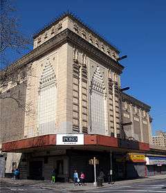
The Loews Pitkin, an opulent 85-foot-high (26 m), 2,827-seat movie theater built in 1929, was among 22 theaters in the area; the rest of the theaters had either been demolished or converted into stores.[3] The Loews Pitkin, named after theater entrepreneur Marcus Loew, had fallen in disuse by the 1970s before being revitalized in the late 2000s.[3][39] The theater's decaying interior was used as a church and a furniture store before Poko Partners bought the space in 2008 and redeveloped the theater into a charter school and retail space for $43 million.[39] The theater was renovated in response to residents' requests for more retail space, and as part of the theater's refurbishment, the charter school would open in 2012 along with 60,000 square feet (5,600 m2) of retail space.[39]
Many of Brownsville's empty lots are now community gardens, which are also widespread in nearby East New York[44] and are maintained by multiple community groups; the gardens are often planted with vegetables that could provide food for residents.[45] The gardens were supposed to be temporary, but they were so popular that in 2015, the New York City government canceled plans to allow developers to build on 34 garden sites in Brownsville (despite nine other gardens in the area having been approved for redevelopment).[46]
The NYPD's 65th Precinct (originally the 73rd Precinct), built in 1901, covered most of the area until its closure in the mid-1980s. The old 65th Precinct building at 1546 East New York Avenue was then sold to a family with the last name of Chen.[47] In 2004, the Chens sold the building to Family Services Network of New York, a nonprofit organization funded by the state government. Family Services borrowed $1.1 million, but failed to pay the mortgage. Despite Family Services' grandiose $3.8 million plan to rehabilitate the 65th Precinct building into a community center, it sits derelict as of 2012, with graffiti on the walls, garbage in the interior, and jail cells still intact.[47]
One block of Livonia Avenue from Barbey Street to Schenck Avenue is designated as "African Burial Ground Square," commemorating an African burial ground at the site that was discovered in 2010.[48] The site contains remains similar to those found in the African Burial Ground National Monument in lower Manhattan, as well as those discovered under the former 126th Street Depot in East Harlem.[49] As part of the designation, the Schenck Playground, behind the New Lots branch of the Brooklyn Public Library, would be rethemed with African cultural motifs and designs.[4]
Hyman Spitz Florists, one of the businesses that dates back to Brownsville's initial settlement, was founded in 1898.[3] It persisted at the same address, 1685 Rockaway Avenue, until 2004. Hyman Spitz Florists had helped provide flowers for such occasions as Donald and Ivana Trump's wedding.[3][50]
Demographics
Based on data from the 2010 United States Census, the population of Brownsville was 58,300, a decrease of 799 (1.4%) from the 59,099 counted in 2000. Covering an area of 750.44 acres (303.69 ha), the neighborhood had a population density of 77.7 inhabitants per acre (49,700/sq mi; 19,200/km2).[2] The entirety of Community Board 16 had 86,377 inhabitants as of NYC Health's 2015 Community Health Profile, with an average life expectancy of 74.1 years.[43]:2 Most inhabitants are young or middle-aged, with 29% between the ages of 0–17, 27% between 25–44, and 22% between 45–64. The ratio of old and college-aged residents was younger, at 10% and 12% respectively.[43]:2
The racial makeup of the neighborhood was 76.1% (44,364) African American, 0.8% (471) White, 0.3% (165) Native American, 0.7% (416) Asian, 0.0% (18) Pacific Islander, 0.3% (180) from other races, and 1.2% (703) from two or more races. Hispanic or Latino of any race were 20.6% (11,983) of the population.[51] 29.9% of the population were high school graduates and 8.4% had a bachelor's degree or higher.[51] This was reflected in the Community Health Profile.[43]:2
As of 2008, the median household income was $15,978.[32] In 2015, an estimated 37% of Brownsville residents lived in poverty, compared to 24% in all of Brooklyn and 21% in all of New York City. One in six residents (16%) were unemployed, compared to 11% in the rest of both Brooklyn and New York City. Rent burden, or the percentage of residents who have difficulty paying their rent, is 56% in Brownsville, slightly higher than the citywide and boroughwide rates of 51% and 52% respectively.[43]:6
Police and crime
The NYPD's 73rd Precinct is located at 1470 East New York Avenue.[52] NYCHA property in the area is patrolled separately by Police Service Area #2 (P.S.A. 2).[53]
Brownsville has consistently been considered to be the murder capital of New York City,[54] with the 73rd Precinct ranking 69th safest out of 69 city precincts for per-capita crime in 2009.[55] That year, there were 3 murders per 10,000 residents (higher than in any other neighborhood in the city), making for 28 overall murders in Brownsville; in overall crime, the 73rd Precinct was the 66th safest out of 69 neighborhoods.[55] In the fifteen years between 1990 and 2005, reports of murder in Brownsville–Ocean Hill dropped to 63 percent (to 22 murders in 2005); robberies 79 percent (to 597 in 2005); and felony assaults decreased 51 percent (to 562 in 2005).[26] Crime rates in Brownsville had declined in the same manner that they had elsewhere in the city, but the declines were not as dramatic as in other areas of the city, with 72 people shot and 15 killed in Brownsville in 2013.[56][57] At 348 per 100,000 adult residents in prison, Brownsville's incarceration rate is three times the city's as a whole and higher than all but one other neighborhood's incarceration rate. At a non-fatal assault rate of 180 per 100,000 people, Brownsville also sees the most violent crimes per capita out of any neighborhood in the city.[43]:7 By contrast, Morrisania, a Bronx neighborhood that once had a crime rate as high as Brownsville's, saw its crime rate decline by 25 percent between 1998 and 2011, while Brownsville's crime rate stayed roughly even during the same time period.[34]
The social problems associated with poverty, from crime to drug addiction, have plagued the area for decades. Despite the decline of crime compared to its peak during the crack and heroin epidemics, violent crime continues to be a serious problem in the community, especially gang-related gun violence.[14][58] Empty lots and unused storefronts are common in Brownsville due to high rates of crime, mostly in the area's public housing developments. A reporter for The New York Times observed that some of the area's playgrounds were inadequately maintained with broken lights and unlocked gates, and that shootings were common in these public housing developments.[59] Brownsville was so dangerous that one UPS driver, robbed at gunpoint, needed an armed security guard to accompany him while delivering packages to houses in the neighborhood.[33] In an effort to reduce crime, the NYPD started a stop-and-frisk program in the early 2000s; this was controversial especially in Brownsville, with 93% of residents in one eight-block area reportedly being stopped and frisked (compared to a 7% rate citywide).[60][61] However, serious crime per resident is decreasing, and from 2000 to 2011, the rate dropped from 45.0 to 35.3 serious crimes per 1,000 residents.[62]
Fire protection
The firehouse for the New York City Fire Department (FDNY)'s Engine Co. 231/Ladder Co. 120 is located in Brownsville.[63]
A new 21,000-square-foot (2,000 m2), $32 million FDNY facility is under construction at 815 Sterling Place in Brownsville. Designed by Chicago-based architectural firm Studio Gang, the new facility will be both an FDNY training center and the firehouse for Rescue Company 2. Ground broke on the project in July 2016.[64][65] The new firehouse, announced in December 2015,[66] will replace Rescue 2's old location, a small building at 1472 Bergen Street in Crown Heights, which was built in the 1920s and has been occupied by Rescue 2 since 1985.[67]
Parks, open spaces, and recreation
Parks
Just east of the Crown Heights–Utica Avenue subway station, on the border with Crown Heights, there is a park called Lincoln Terrace (also known as Arthur S. Somers Park), which slopes gently down toward the southern Brooklyn coastline. The New Lots Line transitions from a tunnel to an elevated structure within this park.[68] The 21 acres (8.5 ha) of land for Lincoln Terrace was purchased by the city in 1895–1897. In order to deter aircraft from flying through the area during World War I, parts of the park had turrets installed in "serviceable but inconspicuous locations" in 1918.[68] Through 1935, additional land was added to the park (including land purchased from the Interborough Rapid Transit Company in 1928, which had built its New Lots Line in 1916). Streets were closed to make room for the extra parkland.[68] The park was originally named after Abraham Lincoln, but in 1932, the western section of the park (west of Rockaway Avenue) was renamed after activist Arthur S. Somers, an area resident who had died that year. Around that time, the park and its playgrounds were refurbished.[68]
Betsy Head Park is located in a lot on the north side of Livonia Avenue bounded by Strauss Street and Thomas S. Boyland Street.[69] Betsy Head, a rich Briton, died in 1907 and gave the city $190,000 to spend on "recreational facilities" as part of her will.[69] When it was opened in 1914, the park, which was then the only one in the neighborhood, was "overcrowded" upon opening.[8]:16 It was lauded for its "rest pavilion, wading pool, playground, school farm garden, bath building, swimming pool, field house, running track, and tennis courts," and in the 1915 Panama–Pacific International Exposition, received first prize in the New York City Parks portion of the competition.[69] In 1936, a new Olympic-size swimming pool, one of 11 across the city, was added as part of a Works Progress Administration project.[70] Three years later, in 1939, the pool was rebuilt after it sustained fire damage.[69] The park was renovated at a cost of $5.2 million in 1983, and a new running track was added in 2001.[69] In 2008, the New York City Landmarks Preservation Commission designated the Betsy Head Play Center a landmark, making it the first and only individual landmark in Brownsville.[70] In early 2016, the playground inside the park was renovated for $5.05 million based on a design by the Rockwell Group, with an "Imagination Playground" surrounded by a 6-foot-tall (1.8 m) wooden pathway. The new play area, which features movable foam play blocks, is based on the group's Burling Slip playground in Lower Manhattan, and builds off several prototype designs for such a playground that were unveiled in Brownsville in 2009.[71]
At Livonia Avenue and Powell Street, Livonia Park is named after Livonia, in the Baltic region in what is now Latvia and Estonia. Livonia Avenue itself is so named for the same reason.[72] According to the New York City Department of Parks and Recreation, the park honors Livonia and its native people, the Livonians. The Livonians were never fully independent, instead being alternatively led by the Teutonic Order, Sweden, and the Russian Empire. The Kingdom of Livonia was a nominal state of Russia from 1570 to 1578 during the Livonian War, but did not actually gain independence.[72] Eventually, the Livonians were assimilated into the larger Latvian population, keeping parts of their language and a few other cultural vestiges. The Russian Empire became communist as part of the October Revolution in 1917, and Latvia and Estonia gained independence soon after, only to become part of communist Russia again until the collapse of the Soviet Union in 1991.[72] The park itself was designated on August 15, 1969, as part of NYCHA's development of the Tilden Houses.[4][72] There are trees, benches, gaming spaces, a drinking fountain, and many grassy plots within the park.[72] The red-and-white bricks in Livonia Park feature the color of the Latvian flag.[4]
Recreation
Brownsville also has its own recreation facility with indoor swimming pools, outdoor athletic fields, and a playground. The Brownsville Recreation Center at the corner of Linden Boulevard, Mother Gaston Boulevard, and Christopher Avenue. Like all other indoor pools in the city, the Brownsville Recreation Center requires a NYC Parks pool membership.[73] It was opened in 1953 as the Brownsville Boys' Club, a "one-room clubhouse" affiliated with the Boys & Girls Clubs of America. Over the next two years, the club raised $1.5 million in funds, and the city opened a brand-new recreation facility.[74] Improvements were made to the center in the late 1990s and 2000s, including $265,000 of general repairs in 1996; $400,000 of heat and air conditioning refurbishments in 1998; and a $1.5 million renovation in 2008 that entailed installing a new playground, improving amenities such as benches and lighting, and replacing the athletic field with artificial turf.[74]
The "Soul in the Hole" is a famous basketball court in Brownsville. The Hole is known for street basketball,[75] and the New York Daily News characterizes it as having the "toughest" streetball competition in Brooklyn.[76] It is located in the Brownsville Houses along Rockaway Avenue between Riverdale and Livonia Avenues.[77] Famous players who played there included Fly Williams.[78]
Other open spaces

The traffic triangle bounded by Pitkin and East New York Avenues and Legion Street was originally named Vanderveer Park after Peter L. Vandeveer, the former owner of the land constituting that triangle.[79] Vanderveer donated the land in 1896, and in 1911, it was renamed Zion Park in recognition of the Jewish community.[79][80] The Zion Park War Memorial, a monumental wall based on a design by sculptor Charles Cary Rumsey and architect Henry Beaumont Herts, was installed in the triangle and dedicated in 1925.[79] This monument features a star of David. The bas relief sculptures are mounted on a limestone stele and side pylons.[79][81]
The Wyckoff Triangle, bounded by New Lots, Riverdale, and Van Siclen Avenues, is named after local property owner Hendrick Wyckoff, who ceded the land used for the traffic triangle.[4] During the American Revolutionary War, Wyckoff was a spy for the colonists rebelling against the British. Through the 1920s, Wyckoff's family maintained the park, which is now privately maintained because it is too small to be a NYC Parks public space.[4]
Politics and government
Brownsville is a heavily Democratic area; in the 2012 presidential campaign, President Barack Obama "won what was very close to a unanimous vote" in the neighborhood.[82]
Brownsville is part of the 20th State Senate district,[83] and the 55th State Assembly district.[84] It is part of District 41 in the New York City Council; since 2006, Democrat Darlene Mealy has held the seat.[85][86][87]
Brownsville was once part of New York's 10th congressional district,[88] but following redistricting in 2012, the neighborhood became part of the 9th congressional district.[89]
In the 2016 Democratic presidential primary, Hillary Rodham Clinton received 4,889 votes (73.9%) to Bernie Sanders's 1,729 votes (26.1%).[90] Brownsville had very few Republican primary voters: just 40 Brownsville voters cast ballots in the 2016 Republican primary.[91]
Health care
Brownsville suffers from major health disparities in comparison to the rest of New York City. In 2006, Brownsville had the highest infant mortality rate in New York City (12.5 per 1,000 births), twice the overall city rate (5.9 per 1,000 births).[92] Preterm and teenage births were also more common in Brownsville than in other places citywide. In Brownsville, there were 13.8 preterm births per 1,000 live births (compared to 9.0 per 1,000 citywide), and 38.5 teenage births per 1,000 live births (compared to 23.6 per 1,000 citywide), giving the area the second-highest teenage birth rate of any neighborhood in the city.[43]:7 In 2015, Brownsville had the lowest average life span (74.1 years) of any New York City neighborhood.[43]:2[93] A New York City Department of Health and Mental Hygiene community health profile the same year found that in Brownsville, the average life expectancy is eleven years shorter than in Manhattan's Financial District.[94] Brownsville has a high population of residents who are uninsured, or who receive healthcare through Medicaid.[95] In 2015, this population of uninsured residents was estimated to be 18%, which is lower than the citywide rate of 20%, and is expected to decrease in coming years because of the enactment of the Affordable Care Act.[43]:10
Air pollution in Brownsville is 0.0088 milligrams per cubic metre (8.8×10⁻⁹ oz/cu ft), slightly higher than the citywide and boroughwide averages.[43]:5 Fourteen percent of Brownsville residents are smokers, which is around the city average of 15% of residents being smokers. In Brownsville, 32% of residents are obese and 15% are diabetic, higher than the citywide averages of 24% and 10% respectively. Eighty-three percent of residents eat some fruits and vegetables every day, which is slightly lower than the city's average of 88%.[43]:8 Despite this, in 2015, four out of five residents (81%) described their health as "good," "very good," or "excellent."[43]:2 There are 15 tobacco stores per 10,000 people (compared to the 11 tobacco stores per ten-thousand people both in Brooklyn and in New York City as a whole), but there are also 277 square feet (25.7 m2) of supermarket footage per 100 people, higher than the citywide average of 177 square feet (16.4 m2) per hundred people and the boroughwide average of 156 square feet (14.5 m2) per hundred people.[43]:5
Brookdale University Hospital and Medical Center is located in the neighborhood. The hospital has suffered from violence; in 2014, the federal Occupational Safety and Health Administration issued a citation to the hospital for "willful" failure to protect hospital employees after an extensive series of incidents of violence against hospital workers took place.[96]
Brownsville has one of the highest rates of psychiatric hospitalization in the city.[97]
Brownsville has historically suffered from high levels of childhood lead exposure from environmental lead, particularly from lead-based paint in dilapidated housing stock.[98][99]
Education
Public schools are operated by the New York City Department of Education. Due to the area's high population density, there are 39 public and charter schools serving elementary and middle school students in Brownsville.[100] Numbered public primary schools include P.S. 150 Christopher; P.S. 156 Waverly; P.S. 165 Ida Posner; P.S. 184 Newport; P.S. 189 Lincoln Terrace; P.S. 219 Kennedy-King; P.S. 284 Lew Wallace; P.S. 298; P.S. 327 Dr Rose B English; P.S. 332 Charles H Houston School; I.S. 392; P.S. 396 Special Education School; P.S. 398 Walter Weaver; P.S. 41 Francis White; P.S. 770 New American Academy; and P.S/I.S. 323 Elementary School.[100]
There are three high schools in Brownsville; two are housed in the same building at 226 Bristol Street. Teachers Preparatory opened in September 2001, while Frederick Douglass Academy VII opened in September 2004. Teachers Preparatory School serves 6th through 12th graders with 99% minority enrollment,[101] receiving a grade of "A" on both its middle school and high school report cards for 2008.[102] FDA VII serves 9th through 12th grades with 99% minority enrollment.[12] The third high school is Brownsville Academy, which is a Diploma Plus transfer school serving 10th through 12th grades with a 100% minority enrollment.[103] It received a "Well Developed" score for 2008–2009.[104] It also received a grade of B on its 2007–2008 report card.[105] Brownsville Academy, a relatively small school with 205 students as of 2016–2017, is located at 1150 East New York Avenue, close to the Crown Heights border.[106]
The Brooklyn Public Library operates a branch on 61 Glenmore Avenue, near Watkins Street.[107]
Brownsville has significantly higher dropout rates in its schools.[108] Brownsville also has one of the highest concentrations of "persistently violent" schools of any area in New York State, with five such schools in Brownsville and East New York on the 2015–2016 list of most dangerous schools.[109][lower-alpha 1] Students must pass through metal detectors and swipe ID cards to enter the buildings.[110] This arose from two school shootings in East New York in 1991–1992 that, combined, resulted in the deaths of three students and the injury of one teacher.[111] Other problems in local schools include low test scores, with 95% of students scoring below grade level on state tests.[112] Brownsville generally has lower ratios of college-educated residents than the rest of the city. Only 18% of the population have a college education or higher, but 28% have less than a high school education and 53% are high school graduates with some college education. By contrast, 38% of Brooklynites and 41% of city residents have a college education or higher.[43]:6 However, despite these drawbacks, the percentage of Brownsville students excelling in reading and math has been increasing, with reading achievement rising from 26 percent in 2000 to 31 percent in 2001, and math achievement rising from 20 percent to 38 percent within the same time period.[62]
Brownsville has the second-highest rate of student homelessness in Brooklyn.[97] It also has the highest rate of elementary school student absenteeism in New York City, with 40 percent of Brownsville elementary school students missing twenty or more days per school year.[43]:7[60][97]
Transportation
Public transportation

The New York City Subway serves Brownsville on the IRT New Lots Line (2 3 4 5 trains) and BMT Canarsie Line (L train). The entire New Lots Line, and the Canarsie Line between Sutter Avenue and New Lots Avenue, are definitively in Brownsville, with the Atlantic Avenue and East 105th Street subway stations at the neighborhood's borders.[113] Due to the lines being created by two different, competing subway companies (the Interborough Rapid Transit Company and the Brooklyn Rapid Transit Company, respectively), a free transit connection does not exist between the two lines, which provide the area's only subway service.[114] A pedestrian bridge from the Livonia Avenue station on the Canarsie Line spans west across the Long Island Rail Road's Bay Ridge Branch to Junius Street, where an entrance to that street's station along the New Lots Line is less than a block away. There are proposals to convert the overpass into a free-transfer passage between the two stations, due to increasing ridership and plans for additional housing in the area.[114] Money is allocated in the Metropolitan Transportation Authority's 2015–2019 Capital Program to build this transfer. The stations would also need to be upgraded to become compliant with mobility accessibility guidelines under the Americans with Disabilities Act of 1990.[115]
MTA Regional Bus Operations operates bus lines in the area. The B15 bus crosses Brownsville horizontally, for the most part using New Lots Avenue; the B14 bus uses Pitkin and Sutter Avenues through its route in the area where Brownsville overlaps with East New York.[116] North–south bus lines include the B7 on Saratoga Avenue; the B60 on Rockaway Avenue; the B82 and B83 on Pennsylvania Avenue (the latter also via Van Siclen Avenue); and the B6 and B84 connecting to the New Lots Avenue station via Ashford Street.[116] The B8, B35, and B47 have segments along the outer borders of Brownsville, and the B8 and B35 both terminate along Hegeman Avenue in the neighborhood's southwestern portion.[116]
In 2011, 72% of residents used public transportation, up from 66% in 2000. More than 85% of residents live within 0.5 miles (0.80 km) of the subway.[24][62]
Streets
The street grid aligns with the general East New York street grid, though ten streets from the Canarsie grid extend into Brownsville. The easternmost of these streets, East 98th Street, serves as the ending point for many main thoroughfares in central Brooklyn, including Church Avenue, Kings Highway, and Sutter Avenues.[4]
As a result of its Jewish heritage, there are several streets named after Jewish community figures in the western portion of Brownsville. In 1913, nine years after writer Theodor Herzl died, residents successfully petitioned to rename Ames Street to Herzl Street, marking one of the few streets outside Israel that are named Herzl Street.[4] One block away, the incorrectly spelled Strauss Street was named after two former Macy's co-owners, brothers Nathan and Isidor Straus, the latter of whom died when his wife Ida gave up a seat on a lifeboat off the sinking RMS Titanic.[4]
One of Brownsville's main thoroughfares, Pitkin Avenue,[117] is named after businessman John R. Pitkin of Connecticut. Pitkin developed East New York starting in 1835.[3]
Hopkinson Street, originally named after Declaration of Independence signer Francis Hopkinson,[118] was renamed in honor of State Assemblyman Thomas S. Boyland, who served the neighborhood from 1977 until his death in 1982.[4] Incidentally, many places in Brownsville, including two schools and a housing development, are named after Boyland and two of his family members (his brother William F. Boyland Sr. and his nephew William Boyland Jr.), who also went into politics and represented Brownsville in various levels of local government.[119]
Stone Avenue was renamed after Rosetta Gaston (1895–1981), founder of the Brownsville Heritage House on the avenue.[4] Mother Gaston, as she was called, operated the Heritage House inside the Stone Avenue Library, a Jacobean Revival-style library built in 1914 by William Tubby.[120]
In popular culture
The 1934 novel Call It Sleep, by Henry Roth, is about the Schearl family, who moves from Brownsville back to the Lower East Side. The main character, young David Schearl, must endure the "terror of poverty" on the Lower East Side. Brownsville, by contrast, is described in the book as a vast improvement over the Lower East Side.[8]:15[121]
Alfred Kazin wrote about 1920s-era Brownsville in his memoir A Walker in the City.[8]:16[34]
Notable people
- Masta Ace (born 1966), rapper[122]
- Albert Anastasia (1902–1957), mobster[123]
- Maurice Ashley (born 1966), chess grandmaster[124]
- Ralph Bakshi (born 1938), film director[125]
- Daniel Benzali (born 1950), Golden-Globe nominated actor[126]
- Riddick Bowe (born 1967), boxer[127]
- Shannon Briggs (born 1971), boxer[128]
- Andrew Dice Clay (born 1957), comedian[129]
- Mickey Cohen (1913–1976), gangster[130]
- Aaron Copland (1900–1990), composer[24]
- Bummy Davis (1920–1945), boxer[131]
- Vince Edwards, actor[132]
- Melech Epstein, journalist and historian
- Fyvush Finkel (1922–2016), actor[133]
- Max Fleischer, animator
- John Forté, rapper[134]
- World B. Free (born 1953), former NBA player
- Nelson George, author[135]
- Marty Glickman, sportscaster
- Don Goldstein, All American and Pan American champion basketball player
- Sid Gordon, baseball player
- Solomon Grayzel, historian[136]
- Arnold Greenberg, co-founder of Snapple[137]
- Henry Hill (1943–2012), mobster associated with the Vario Crew and Lucchese crime family
- Red Holzman (1920–1998), NBA player and coach
- Moe, Curly, and Shemp Howard who were brothers and members of The Three Stooges
- Gregory "Jocko" Jackson, community leader and NBA player[138]
- Daniel Jacobs, boxer
- Charles Jenkins, NBA player
- Zab Judah, boxer
- KA, rapper
- Donald Kagan, historian
- Danny Kaye, entertainer[3][24]
- Alfred Kazin, writer and literary critic[139]
- Larry King (born 1933), television and radio host[24]
- Alvin Klein (c.1938–2009), theater critic for The New York Times[140]
- Jack Knight, songwriter, music producer, motivational speaker
- Meyer Lansky (1902–1983) noted underworld figure
- Steve Lawrence, singer
- Leonard Marsh, co-founder of Snapple
- Duane Martin, actor
- Zero Mostel, actor
- M.O.P., hip hop duo
- Eddie Mustafa Muhammad, former boxer
- Alex B. Novikoff, scientist
- O.G.C., hip hop group
- Abe Osheroff, political activist
- Joseph Papp (1921–1991), theatrical producer/director[3]
- Bruce Pasternack, business author
- Norman Podhoretz, writer[24][141]
- Sean Price (1972–2015), rapper[142]
- Killah Priest, rapper
- Isidor Isaac Rabi (1898–1988), physicist and 1944 Nobel Prize Laureate for his discovery of nuclear magnetic resonance[143]
- Paul Rand, graphic designer
- Willie Randolph, former baseball player, manager, and coach
- Abe Reles, mobster
- Representativz, hip hop duo
- RZA, rapper, member of the Wu-Tang Clan
- Meyer Schapiro, art historian, member of the faculty of Columbia University for 45 years[144]
- Phil Sellers, former NBA player
- Al Sharpton, minister
- Phil Silvers, comic
- Jimmy Smits, actor
- Bern Nadette Stanis, actress[145]
- Steele, hip hop artist
- Heltah Skeltah, hip hop group
- Mike Tyson (born 1966), boxer[3][146]
- Dwayne "Pearl" Washington (1964–2016), late professional basketball player[147]
- James "Fly" Williams, former NBA player
- Nicole Willis, singer-songwriter
- Otis Wilson (born 1957), former NFL linebacker[148]
- Terry Winters (born 1949), artist[149]
- Max Zaslofsky (1925–1985), professional basketball player and coach[150]
- Howard Zinn (1922–2010), historian[24]
Notes
- ↑ These schools are Brownsville Collaborative Middle School, East New York Elementary School of Excellence, East New York Middle School of Excellence, PS 150 Christopher, and PS 213 New Lots.
References
- 1 2 "Brownsville neighborhood in New York". Retrieved June 4, 2014.
- 1 2 Table PL-P5 NTA: Total Population and Persons Per Acre – New York City Neighborhood Tabulation Areas*, 2010, Population Division – New York City Department of City Planning, February 2012. Accessed June 15, 2016.
- 1 2 3 4 5 6 7 8 9 10 11 12 13 14 15 "BROWNSVILLE and EAST NEW YORK, Brooklyn". Forgotten New York. 2005-06-13. Retrieved 2016-10-03.
- 1 2 3 4 5 6 7 8 9 10 11 12 13 Kadinsky, Sergey (September 2016). "LIVONIA AVENUE, East New York". Forgotten New York. Retrieved 2016-10-03.
- ↑ Spellen, Suzanne (2015-01-05). "Building of the Day: 630 New Lots Avenue". Brownstoner. Retrieved 2016-10-04.
- ↑ Anne B. Covell (March 1983). "National Register of Historic Places Registration:New Lots Reformed Church and Cemetery". New York State Office of Parks, Recreation and Historic Preservation. Retrieved 2011-02-20. See also: "Accompanying six photos".
- ↑ National Park Service (2009-03-13). "National Register Information System". National Register of Historic Places. National Park Service.
- 1 2 3 4 5 6 7 8 9 10 11 12 13 14 15 16 17 18 19 20 21 22 23 24 25 26 27 28 29 30 31 32 33 Thomas, J.A.; Pritchett, Wendell E.; Moss, C.F.; Vater, M. (2002). Brownsville, Brooklyn: Blacks, Jews, and the Changing Face of the Ghetto. Historical Studies of Urban America. University of Chicago Press. ISBN 978-0-226-68446-8.
- 1 2 3 4 5 6 7 8 9 10 11 Williams, Keith. "Brownsville and the curse of geography". The Weekly Nabe. Retrieved June 15, 2012.
- ↑ "Brooklyn, NY Brownsville Tenement Collapse, Jan 1935". GenDisasters ... Genealogy in Tragedy, Disasters, Fires, Floods. 1935-01-02. Retrieved 2016-10-04.
- 1 2 "New York city guide; a comprehensive guide to the five boroughs of the metropolis: Manhattan, Brooklyn, the Bronx, Queens, and Richmond". archive.org. Retrieved 2015-12-06.
- 1 2 Levitt, Ellen (2009). The Lost Synagogues of Brooklyn: The Stories Behind how and why Many Brooklyn Synagogues, Now Old "ex-shuls," Were Converted to Other Uses, Primarily as Christian Churches. Avotaynu. ISBN 978-1-886223-39-4. Retrieved 2016-10-03.
- ↑ "New York city guide; a comprehensive guide to the five boroughs of the metropolis: Manhattan, Brooklyn, the Bronx, Queens, and Richmond". archive.org. Retrieved 2015-12-06.
- 1 2 3 4 5 6 7 8 9 10 11 12 13 14 Bellafante, Ginia (2013-04-17). "Resurrecting Brownsville". The Nation. Retrieved 2016-10-04.
- ↑ Spellen, Suzanne (2012-01-06). "Past and Present: Fortunoff's". Brownstoner. Retrieved 2016-10-04.
- ↑ Ruderman, Wendy (2012-08-31). "Ice Picks Are Still Used as Weapons". The New York Times. ISSN 0362-4331. Retrieved 2016-10-04.
- 1 2 3 Podair, Jerald (2002). The Strike that Changed New York. New Haven and London: Yale University Press. p. 288. ISBN 978-0-300-10940-5.
- 1 2 Ortega, Tony (March 11, 2010). "Absolutely Nothing To Get Alarmed About Village Voice September 14, 1967". Village Voice. Retrieved January 24, 2011.
- 1 2 Cannato, Vincent "The Ungovernable City: John Lindsay and his struggle to save New York" Better Books, 2001; ISBN 0-465-00843-7
- 1 2 "Herald-Journal". Google News Archive Search. 2016-09-15. Retrieved 2016-10-03.
- ↑ Staff (January 2, 2011). "Negro Policemen Sent to Patrol Scene of Disorders in Brooklyn - Article". New York Times. Retrieved January 24, 2011.
- ↑ Berube, Maurice R. and Marilyn Gittell. Confrontation at Ocean Hill-Brownsville; the New York school strikes of 1968 New York, Praeger [1969] OCLC: 19279
- ↑ "John Lindsay'S Ten Plagues". TIME. November 1, 1968. Retrieved January 24, 2011.
- 1 2 3 4 5 6 7 8 Vitullo-Martin, Julia (2013-01-17). "Is Brownsville Brooklyn Ready for its Jane Jacobsian Comeback?". Untapped Cities. Retrieved 2016-10-06.
- 1 2 3 Johnson, Thomas A. (1971-05-08). "Brownsville Back to Normal Despair". The New York Times. ISSN 0362-4331. Retrieved 2016-10-04.
- 1 2 3 4 5 6 7 8 9 Bleyer, Jennifer (2007-06-17). "At Long Last, Developers Show an Interest". The New York Times. Retrieved 2016-10-03.
- 1 2 Lelyveld, Joseph (1970-06-13). "Brownsville Erupts in Violence Over Huge Accumulations of Garbage". The New York Times. Retrieved 2016-10-06.
- ↑ Gottlieb, Melinda (2015-06-24). "Advance historic page from May 7, 1971: B'klyn prepares for second day of rioting". SILive.com. Retrieved 2016-10-04.
- 1 2 Bellafante, Ginia (2013-06-01). "In Marcus Garvey Village, a Housing Solution Gone Awry". The New York Times. ISSN 0362-4331. Retrieved 2016-10-04.
- ↑ See:
- Sheftell, Jason (July 27, 2012). "Spring Creek Nehemiah is an affordable housing success story: in East New York: The development off Flatlands Ave. is home to 233 first-time homeowners who won the right to live there via lottery.". Daily News. Retrieved November 16, 2015.
- Hughes, C.J. (August 27, 2006). "Affordable Houses Infused With Color". The New York Times. Retrieved November 19, 2015.
- Merkel, Jayne (August 23, 2010). "Irrational Exuberance Comes Home". The New York Times. Retrieved November 19, 2015.
- Gonzalez, David (April 1, 1998). "About New York; A Project Called Hope, Unrealized". The New York Times. Retrieved November 19, 2015.
- Swartz, Tracy (August 4, 2006). "A PLACE TO CALL HOME. 2,200 AFFORDABLE HOMES PLANNED FOR E. NEW YORK". Daily News. Retrieved 11 December 2015.
- ↑ Sun, Feifei (January 31, 2012). "Brownsville: Inside One of Brooklyn's Most Dangerous Neighborhoods". TIME.com.
- 1 2 3 "Median household income from census records" (PDF). nyc.gov. Retrieved October 30, 2014.
- 1 2 3 Sun, Feifei. "Brownsville: Inside One of Brooklyn's Most Dangerous Neighborhoods". TIME.com. Retrieved 2016-10-04.
- 1 2 3 4 Bellafante, Ginia (2012-01-14). "New York City's Optimistic Tone Feels Out of Reach in Brownsville". The New York Times. ISSN 0362-4331. Retrieved 2016-10-06.
- ↑ "Brownsville Long Island New York". Longislandexchange.com. December 22, 2006. Retrieved January 24, 2011.
- ↑ "CAU – Find Your Community Board – Brooklyn Community Boards". www.nyc.gov. Retrieved 2016-10-04.
- ↑ Semuels, Alana (May 19, 2015). "New York City's Public-Housing Crisis". The Atlantic. Retrieved 2016-10-06.
- 1 2 3 4 5 6 7 8 9 10 11 12 13 14 15 16 17 18 19 "NYCHA locations in Brownsville". Nyc.gov. September 28, 2010. Retrieved January 24, 2011.
- 1 2 3 4 5 Pristin, Terry (2010-09-29). "Loew's Pitkin, Former Movie Palace in Brooklyn, Gets a New Life". The New York Times. Retrieved 2016-10-03.
- 1 2 Rosenberg, Zoe (2014-12-05). "Livonia Avenue Initiative; Typographic Building Numbers". Curbed NY. Retrieved 2016-10-04.
- 1 2 Wolf, Jonah (2012-09-28). "East New York's Livonia Commons: Affordable Housing Vision Gets Visual Aids". Observer. Retrieved 2016-10-04.
- ↑ Walker, Ameena (2016-09-24). "East New York celebrates the creation of 710 affordable apartments". Curbed NY. Retrieved 2016-10-04.
- 1 2 3 4 5 6 7 8 9 10 11 12 13 14 15 "Brooklyn Community District 16: BROWNSVILLE (Including Broadway Junction, Brownsville and Ocean Hill)" (PDF). nyc.gov. NYC Health. 2015. Retrieved 2016-10-04.
- ↑ "EAST NEW YORK COMMUNITY GARDENS". Forgotten New York. September 2002. Retrieved 2016-10-03.
- ↑ Vela, Yvette (2012-02-13). "Community gardens springing up in Brownsville". Brownsville Herald. Retrieved 2016-10-03.
- ↑ Bautista, Camille (2015-12-31). "34 Community Gardens Saved From Demolition After City Makes Them Parks". DNAinfo New York. Retrieved 2016-10-03.
- 1 2 Maisel, Todd; Weichselbaum, Simone (2012-03-29). "Old NYPD Brownsville precinct is crumbling eyesore; new owners can't pay to fix it". NY Daily News. Retrieved 2016-10-04.
- ↑ "Area in East New York Renamed 'African Burial Ground'". Colorlines. 2013-10-18. Retrieved 2016-10-04.
- ↑ Lyons, Jarrett (2016-07-12). "The History of Recovering NYC African Burial Grounds". Untapped Cities. Retrieved 2016-10-04.
- ↑ Vandam, Jeff (2004-09-05). "NEIGHBORHOOD REPORT: BROWNSVILLE; A 19th-Century Survivor Ships Its Last Fragrant Bouquet". Retrieved 2016-10-04.
- 1 2 Table PL-P3A NTA: Total Population by Mutually Exclusive Race and Hispanic Origin – New York City Neighborhood Tabulation Areas*, 2010, Population Division – New York City Department of City Planning, March 29, 2011. Accessed June 14, 2016.
- ↑ "NYPD – 73rd Precinct". www.nyc.gov. Retrieved 2016-10-03.
- ↑ "Housing Bureau".
- ↑ Konigsberg, Eric (June 19, 2014). "Woo Cho Bang Bang". New York. Retrieved 2016-10-06.
- 1 2 "Brownsville – DNAinfo.com Crime and Safety Report". www.dnainfo.com. Retrieved 2016-10-06.
- ↑ Long, Colleen and Tom Hays. "Crime is down, but decline lags in NY neighborhood." Associated Press at Houston Chronicle. December 30, 2013. Retrieved on December 30, 2013.
- ↑ Secret, Mosi (2014-05-01). "On the Brink in Brownsville". The New York Times. ISSN 0362-4331. Retrieved 2016-10-04.
- ↑ "73rd Precinct CompStat Report" (PDF). Retrieved January 24, 2011.
- ↑ Bellafante, Ginia (2016-01-15). "Brownsville's Broken Windows". The New York Times. ISSN 0362-4331. Retrieved 2016-10-03.
- 1 2 Trotta, Daniel (2010-07-30). "Brownsville, the 'hood that New York left behind". Reuters. Retrieved 2016-10-04.
- ↑ Orr, Matthew (2010-07-12). "Stop and Frisk in Brownsville, Brooklyn". The New York Times. ISSN 0362-4331. Retrieved 2016-10-04.
- 1 2 3 "Brownsville – BK 16" (PDF). Furman Center for Real Estate and Urban Policy. 2011. Retrieved 2016-10-05.
- ↑ Joe Kemp & Corinne Lestch, Retiring FDNY captain served as father figure in Brooklyn neighborhood, New York Daily News (April 6, 2014).
- ↑ Amy Plitt, Studio Gang Is Designing a Brownsville FDNY Training Center, Curbed (January 29, 2016).
- ↑ Jason Sayer, Studio Gang’s ecological firehouse and training facility breaks ground today, The Architect's Newspaper (July 28, 2016).
- ↑ Holliday Smith, Rachel (December 16, 2015). "Crown Heights Rescue Company to Get New Firehouse in Brownsville, FDNY Says". DNAinfo New York. Retrieved 2016-10-08.
- ↑ Spellen, Suzanne (2012-09-11). "Building of the Day: 1472 Bergen Street". Brownstoner. Retrieved 2016-10-08.
- 1 2 3 4 "Lincoln Terrace / Arthur S. Somers Park". New York City Department of Parks and Recreation. Retrieved 2016-10-03.
- 1 2 3 4 5 "Betsy Head Park". New York City Department of Parks and Recreation. Retrieved 2016-10-03.
- 1 2 "Designation Report-Betsy Head Play Center" (PDF). New York City Landmarks Preservation Commission. September 16, 2008. Retrieved March 10, 2014.
- ↑ Wachs, Audrey (2016-04-20). "Rockwell Group–designed Imagination Playground opens in Brownsville, Brooklyn". The Architect's Newspaper. Retrieved 2016-10-03.
- 1 2 3 4 5 "Livonia Park Highlights". New York City Department of Parks and Recreation. Retrieved 2016-10-04.
- ↑ "Brownsville Playground Indoor Pools". New York City Department of Parks and Recreation. Retrieved 2016-10-05.
- 1 2 "Brownsville Playground History". New York City Department of Parks and Recreation. Retrieved 2016-10-05.
- ↑ Armstrong, Kevin (2016-03-14). "The Courts of Kings: Brooklyn hoop history on center stage". NY Daily News. Retrieved 2016-10-03.
- ↑ Romano, Denise; Pearson, Jake (2010-05-24). "Best of the boroughs: Brooklyn sports". NY Daily News. Retrieved 2016-10-03.
- ↑ "Best of the boroughs: Brooklyn sports".
- ↑ "Elite 24: Rucker Park legends". ESPN. 2012-06-21. Retrieved 2016-10-03.
- 1 2 3 4 "Zion Triangle Monuments: Zion Park War Memorial". New York City Department of Parks and Recreation. Retrieved 2016-10-03.
- ↑ "History & Culture". Pitkin Avenue BID. Retrieved 2010-07-16.
- ↑ "Charles Cary Rumsey". Buffalo Architecture and History. Retrieved 2010-07-16.
- ↑ The City Vote, Precinct by Precinct, New York Times (November 23, 2012).
- ↑ Nikita Stewart, 2 Lawyers Are Seeking Senate Seat in Brooklyn, New York Times (September 5, 2014).
- ↑ Liz Robbins, A Lawmaker Back in Trouble, in a District That Knows Despair, New York Times (November 30, 2011).
- ↑ Election 2013: City Council Results, New York Times.
- ↑ Darlene Mealy District 41 – Council Member – Democrat, New York City Council.
- ↑ Jim Dwyer, Standing in the Way of a Community Court in Brooklyn, New York Times (January 12, 2016).
- ↑ Matt Flegenheimer, Towns Is Said to Decline to Run Again for Congress, New York Times (April 16, 2012).
- ↑ New York Redistricting, New York Times (March 20, 2012).
- ↑ Matthew Bloch & Wilson Andrews, How Every New York City Neighborhood Voted in the Democratic Primary, New York Times (April 20, 2016).
- ↑ Matthew Bloch & Wilson Andrews, How Every New York City Neighborhood Voted in the Republican Primary, New York Times (April 20, 2016).
- ↑ Jennifer 8. Lee, Disparities in Infant Mortality Persist by Neighborhood and Race, New York Times (October 3, 2007).
- ↑ Sabrina Tavernise & Albert Sun, Same City, but Very Different Life Spans, New York Times (April 28, 2015).
- ↑ Jonathan LaMantia, A troubling portrait of Brooklyn's overall health is released, Crain's New York (October 15, 2015).
- ↑ New York City Health Provider Partnership Brooklyn Community Needs Assessment: Final Report, New York Academy of Medicine (October 3, 2014).
- ↑ Robert Lewis, Violence Out of Control at Brooklyn Hospital: OSHA, WNYC (August 11, 2014).
- 1 2 3 Meredith Kolodner, At a school in Brooklyn's poorest neighborhood, literacy is up and disciplinary problems are down, Hechinger Report, Teachers College, Columbia University (November 4, 2015).
- ↑ Eric A. Goldstein & Mark A. Izeman, The New York Environment Book (Natural Resources Defense Council/Island Press, 1990), p. 172: "Four low-income areas in Brooklyn—Bedford-Stuvyesant, Brownsville, Bushwick, and Fort Greene—have recorded almost 50 percent of the reported cases of lead poisoning in New York City from 1970 to 1988. This figure reflects the concentration of older and often deteriorated housing in what is sometimes referred to as the city's 'lead belt.'".
- ↑ David Stradling, The Nature of New York: An Environmental History of the Empire State (Cornell University Press, 2010), p. 208: "After a door-to-door survey in Brownsville, Brooklyn College announced that up to 45 percent of that neighborhood's families might have lead poisoning."
- 1 2 "11212 (Brooklyn, NY) Public Schools". PublicSchoolReview.com. 2016-09-22. Retrieved 2016-10-04.
- ↑ "How Does Teachers Preparatory High School Rank Among America's Best High Schools?". www.usnews.com. Retrieved 2016-10-03.
- ↑ "Statistics – Teachers Preparatory High School – K697". New York City Department of Education. August 9, 2007. Retrieved January 24, 2011.
- ↑ "How Does Brownsville Academy High School Rank Among America's Best High Schools?". U.S. News & World Report. Retrieved 2016-10-03.
- ↑ "Quality Review Report 2008-2009 – Brownsville Academy High School – High School 568 – 1150 East New York Avenue, Brooklyn, NY 11212" (PDF). New York City Department of Education. 2009. Retrieved 2016-10-04.
- ↑ "Progress Report TRANSFER SCHOOL 2007–08" (PDF). New York City Department of Education. 2008. Retrieved 2016-10-04.
- ↑ "Brownsville Academy High School". SchoolBook. Retrieved 2016-10-03.
- ↑ "Brownsville Library". Brooklyn Public Library. 2016-10-04. Retrieved 2016-10-04.
- ↑ "NYC Dropout Rates". Gotham Gazette. Citizens Union Foundation of the City of New York. March 20, 2006. Retrieved January 24, 2011.
- ↑ "2015–16 Persistently Dangerous Schools Designation Based on Violent and Disruptive Incident Reporting" (PDF). New York State Education Department. 2016. Retrieved 2016-10-05.
- ↑ Khan, Daryl (2012-09-20). "Perps or Pupils? Safety Policy Creates Prison-like New York City Schools". Juvenile Justice Information Exchange. Retrieved 2016-10-06.
- ↑ Mindy Thompson Fullilove et al. (2003). "What Did Ian Tell God?: School Violence in East New York". In Mark H. Moore, Carol V. Petrie, Anthony A. Braga & Brenda L. McLaughlin. Deadly Lessons: Understanding Lethal School Violence. The National Academies Press. doi:10.17226/10370.
- ↑ Talty, Alexandra (2014-07-31). "Learning In Brownsville, New York: Challenges For A Community Organizer". Forbes. Retrieved 2016-10-04.
- ↑ "Subway Map" (PDF). Metropolitan Transportation Authority. November 2016. Retrieved 2016-11-07.
- 1 2 Eisinger, Dale W.; Rivoli, Dan (July 6, 2015). "Brooklyn official wants transfer at 2 nearby subway stations in East New York". Daily News. Retrieved 25 October 2015.
- ↑ "MTA Capital Program 2016–2019: Renew. Enhance. Expand." (PDF). Metropolitan Transportation Authority. October 28, 2015. Retrieved 28 October 2015.
- 1 2 3 "Brooklyn Bus Map" (PDF). Metropolitan Transportation Authority. 2016. Retrieved October 3, 2016.
- ↑ "Report: New York City Walmart jobs would lower wages". Abclocal.go.com. January 13, 2011. Retrieved October 11, 2012.
- ↑ "NYC STREETS FEATURING FULL NAMES". Forgotten New York. November 2013. Retrieved 2016-10-03.
- ↑ Bleyer, Jennifer (2005-11-06). "The Kennedys of Brownsville". The New York Times. Retrieved 2016-10-03.
- ↑ Spellen, Suzanne (2015-04-30). "581 Mother Gaston Boulevard, a Bastion of Knowledge in Brownsville". Brownstoner. Retrieved 2016-10-03.
- ↑ Severo, Richard (1995-10-14). "Henry Roth Is Dead at 89; Wrote Novel 'Call It Sleep'". The New York Times. Retrieved 2016-10-04.
- ↑ Robinson, Stewart. "Masta Ace Speaks On His New Album The Falling Season & More In This Exclusive Interview", The Hip Hop Crib, February 19, 2016. Accessed June 15, 2016. "Masta Ace, a hip hop artist from Brownsville, has been in the game for almost 30 years now."
- ↑ McLoughlin, Tim. Brooklyn Noir 3: Nothing But the Truth, p. 66. Akashic Books, 2008. ISBN 9781933354149. Accessed June 15, 2016. "The proprietor of Murder Inc. was a Brownsville homeboy by the name of Albert Anastasia, a.k.a. 'Lord High Executioner.'"
- ↑ Stewart, Barbara. "From Kings County, First Black Grandmaster", The New York Times, March 17, 1999. Accessed June 15, 2016. "Twenty years ago, when Maurice Ashley was 14 and living in Brownsville, Brooklyn, he was soundly defeated in an offhand game of chess."
- ↑ Glinter, Ezra. "Inventor of X-Rated Animation Ralph Bakshi Makes a Comeback", The Forward, January 14, 2014. Accessed June 15, 2016. "Bakshi knows a thing or two about grime. Born in Haifa in 1938, he left Palestine with his parents at age 1 and settled in the Brooklyn neighborhood of Brownsville."
- ↑ "Daniel Benzali". Suckers. Archived from the original on January 27, 2007. Retrieved December 13, 2006.
- ↑ Vadukul, Alex. "Ex-HeavyweightChampion Riddick BoweSteps Into a New Arena; After two boxing world titles, prison and bankruptcy, Mr.Bowe hopes to cement another legacy: as a restaurateur.", The New York Times, August 21, 2015. Accessed June 15, 2016. "When Mr. Bowe first held his title belt aloft, his bleak childhood in Brownsville, Brooklyn, must have felt incomprehensibly far away."
- ↑ Alvarado, Francisco. "Shannon Briggs Returns to Boxing, Hosts Fight Celebration at Wonderland Saturday", Miami New Times, April 10, 2014. Accessed June 15, 2016. "Briggs was born on Dec. 4, 1971 in Brownsville, back then 'the worst hood in America,' the ex-champ relates."
- ↑ Roura, Phil. "It's potty time: Foulmouthed funnyman Andrew Dice Clay on the comeback trail", New York Daily News, Juky 23, 2011. Accessed June 15, 2016. "Born in Brownsville, Brooklyn, 53 years ago, Andrew Clay Silverstein patterned himself after the outrageous humor of Lenny Bruce and Richard Pryor."
- ↑ Kirsch, Jonathan. "Mickey Cohen’s colorful life of crime", The Jewish Journal of Greater Los Angeles, August 22, 2012. Accessed June 15, 2016. "Meyer Harris Cohen was born in the Jewish Pale of Settlement in imperial Russia, immigrated with his family to the Brownsville neighborhood of Brooklyn and reached Los Angeles’ Jewish point of entry in Boyle Heights in 1915."
- ↑ Krajicek, David J. "As NYC's murder rate soared in 1945, noted lightweight boxer Al (Bummy) Davis is gunned down during bar robbery", New York Daily News, September 12, 2015. Accessed June 15, 2016. " He was better known as Al (Bummy) Davis, a lightweight boxer of note. He grew up in the Jewish ghetto of Brownsville, Brooklyn, delivering knuckle sandwiches to his family’s pushcart competitors along Blake Ave."
- ↑ William Grimes, Vince Edwards, 67, the Doctor In the Hit TV Series 'Ben Casey', New York Times (March 13, 1996): "Mr. Edwards was born in the Brownsville section of Brooklyn."
- ↑ Fyvush Finkel Remembers the Yiddish Theaters in Brownsville, Brooklyn, Wexler Oral History Project, Yiddish Book Center: "Fyvush Finkel, z"l—comedian, actor, and singer—describes attending and performing in the Yiddish theaters as a child in the Brownsville section of Brooklyn, New York.
- ↑ Peter Wilkinson, John Forte's Rap: An exclusive jailhouse talk with the Fugee songwriter, Rolling Stone (August 27, 2002): "A native of the roughneck Brownsville, Brooklyn, Forte has always been something of a hip-hop anomaly."
- ↑ Bhattacharyya, Arpan (2008-02-04). "Growing Up in Brooklyn". Big Think. Retrieved 2016-10-06.
- ↑ Alter F. Landesman, Brownsville: The Birth, Development and Passing of a Jewish Community in New York (Bloch Publishing Company, 1971), p. 260: "Other Seminary graduates who lived in Brownsville, and became leaders in American Jewish life are ... Dr. Solomon Grayzel, eminent Jewish historian..."
- ↑ Fox, Margalit (October 30, 2012). "Arnold Greenberg, a Founder of Snapple, Dies at 80". New York Times. Retrieved November 18, 2012.
- ↑ Joseph Tepper, Greg "Jocko" Jackson, Brownsville's "unofficial mayor" dead at 60, New York Daily News (May 3, 2012): "BROOKLYN is mourning the loss of Greg "Jocko" Jackson, the 'unofficial mayor' of Brownsville. Jackson, who served as the manager of the Brownsville Recreation Center for 15 years ... grew up playing basketball at the Brownsville Recreation Center on Linden Blvd. and made it all the way to the NBA."
- ↑ Salamon, Julie. "Toil, Tears and Sweat in Brooklyn", The New York Times, February 6, 2004. Accessed November 19, 2007. "The words of a native son, Alfred Kazin, spoken by an actor evoking the writer's Brownsville childhood in the 1920s, resonate today."
- ↑ Staff. "Alvin Klein, Times Theater Reviewer, Dies at 73", The New York Times, March 6, 2009. Accessed June 7, 2016. "The son of immigrants from Poland, Mr. Klein was born in Brownsville, Brooklyn, and grew up in Flatbush."
- ↑ Podhoretz, Norman (February 1963). "My Negro Problem — And Ours" (PDF). Commentary. Retrieved May 14, 2010.
- ↑ Caramanica, Jon. "Sean Price, Rapper With Deep Brooklyn Roots, Dies at 43", The New York Times, August 9, 2015. Accessed June 15, 2016. "Sean Price, a rapper who for two decades embodied the rugged essence of peak-era Brooklyn hip-hop, died in his sleep on Saturday morning at his home in the Brownsville section of Brooklyn.... 'The best rapper in Brownsville,' he boasted in a 2009 song, as if that were still the most important thing to him."
- ↑ Berger, Marilyn. "Isidor Isaac Rabi, a Pioneer In Atomic Physics, Dies at 89", The New York Times, January 12, 1988. Accessed July 29, 2016. "'I'm an omnivorous reader,' he said, looking back at his discovery of the local branch of the Brooklyn Public Library after moving to the Brownsville section of Brooklyn when he was a child."
- ↑ John Russell, Meyer Schapiro, 91, Is Dead; His Work Wove Art and Life, New York Times (March 4, 1995): "With his family settled in the Brownsville section of Brooklyn, Nathan Schapiro prospered as a paper-and-twine jobber. ... Like many another brilliant Jewish student at that time, [Meyer Schapiro] found a second home in the Hebrew Settlement House in Brownsville..."
- ↑ Elizabeth Blair, From 'Good Times' To 'Honey Boo Boo': Who Is Poor On TV?, NPR, Morning Edition (August 5, 2014): "I too was raised in the projects in Brooklyn, N.Y., in the Brownsville neighborhood."
- ↑ "Mike Tyson Biography". BookRags.
- ↑ Vecsey, George. "SPORTS OF THE TIMES; The Pearl Fits In At Syracuse", The New York Times, March 9, 1984. Accessed December 5, 2007. "This part of the legend does survive: Washington admits that when he was 8 years old at the Howard Housing Project in Brownsville, his elders asked him: Who do you think you are, the Pearl?"
- ↑ Staff. "SPORTS WORLD SPECIALS; Ego Boost", The New York Times, January 27, 1986. Accessed July 29, 2016. "Wilson grew up in Brownsville and went to Thomas Jefferson High School, then attended the University of Louisville before the Bears drafted him on the first round in 1980."
- ↑ Rosenthal, Nan; and Winters, Terry. Terry Winters: Printed Works, p. 6. Metropolitan Museum of Art, 2001. ISBN 9780300090833. Accessed July 29, 2016. "Winters was born in 1949 and grew up in Brooklyn, for the first decade of his life in Brownsville, then a large lower-middle-class Jewish community, and later in the slightly more upscale neighborhoods of Midwood and Flatbush."
- ↑ Cromie, Robert. "Zalofsjy – the Dizzy Dean of Basketball Minus Sound", Chicago Tribune, February 14, 1949. Accessed July 29, 2016. "Zaslofsky was born in the Brownsville section of Brooklyn and at 6 got a basketball from his father."
Sources
- Thomas, J.A.; Pritchett, Wendell E.; Moss, C.F.; Vater, M. (2002). Brownsville, Brooklyn: Blacks, Jews, and the Changing Face of the Ghetto. Historical Studies of Urban America. University of Chicago Press. ISBN 978-0-226-68446-8.
Further reading
| Wikimedia Commons has media related to Brownsville, Brooklyn. |
- Landesman, A.F. (1971). Brownsville: the birth, development, and passing of a Jewish community in New York. Bloch Pub. Co.
- Berube, Maurice R.; Gittell, Marilyn, eds. (1969). Confrontation at Ocean Hill-Brownsville; the New York school strikes of 1968. Praeger.
- Dubowsky, H.L. (1976). A Community Study of Brownsville, Brooklyn, New York. Hy L. Dubowsky.
- Glauber, R. (1963). All Neighborhoods Change: A Survey of Brownsville, Brooklyn, U.S.A.
- Urban renewal in Brownsville; the management of urban renewal in Brownsville area 15, 1960–1973. New York (State); State Study Commission for New York City; Housing and Development Administration Study Group. 1973.
- Jackson, K.T.; Manbeck, J.B.; Citizens Committee for New York City (2004). The Neighborhoods of Brooklyn. The neighborhoods of New York City. Citizens for NYC. ISBN 978-0-300-10310-6.