Coney Island
| Coney Island | |
|---|---|
| Neighborhood of Brooklyn | |
|
| |
 Coney Island  Coney Island  Coney Island Location | |
| Coordinates: 40°34′27.9″N 73°58′42.9″W / 40.574417°N 73.978583°WCoordinates: 40°34′27.9″N 73°58′42.9″W / 40.574417°N 73.978583°W | |
| Country | United States |
| State | New York |
| City | New York City |
| Borough | Brooklyn |
| Settled | 17th century |
| Founded by | Dutch settlers |
| Area | |
| • Total | 0.6910000 sq mi (1.7896818 km2) |
| Population (2010) | |
| • Total | 24,711 |
| • Density | 36,000/sq mi (14,000/km2) |
| Time zone | Eastern Time Zone (UTC– 05:00) |
| ZIP code | 11224 |
| Telephone area code | 718, 347, 929, and 917 |

Coney Island is a peninsular residential neighborhood, beach, and leisure/entertainment destination on the Coney Island Channel, which is part of the Lower Bay in the southwestern part of the borough of Brooklyn, New York City. The site was formerly an outer barrier island but became partially connected to the rest of Long Island by land fill. The residential portion of the peninsula is a community of 60,000 people in its western part, with Sea Gate to its west, Brighton Beach and Manhattan Beach to its east, the Lower Bay to the south, and Gravesend to the north.
Coney Island is well known as the site of amusement parks and a seaside resort. The attractions reached a historical peak during the first half of the 20th century, declining in popularity after World War II and years of neglect. In recent years, the area has seen the opening of MCU Park stadium and has become home to the Brooklyn Cyclones minor league baseball team, as well as the opening of a new amusement park among several adjacent ones.
Geography

Coney Island is the westernmost part of the barrier islands of Long Island, and is about 4 miles (6.4 km) long and 0.5 miles (0.80 km) wide lying between Sheepshead Bay to the east and Lower New York Bay to the west. It was formerly an island that was separated from the main part of Brooklyn by Coney Island Creek, a partial tidal mudflats, but it has since been developed into a peninsula. There were plans early in the 20th century to dredge and straighten the creek as a ship canal, but they were abandoned, and the center of the creek was filled in completely to allow construction of the Belt Parkway before World War II, and it was filled in again in 1962 with the construction of the Verrazano–Narrows Bridge.[1] The western and eastern ends of the island are now peninsulas.
History
Settlement and name
The original Native American inhabitants of the region were the Lenape, who called the island Narrioch. This name has been attributed the meaning of "land without shadows"[2] or "always in light"[3] describing how its south facing beaches always remained in sunlight. A second meaning attributed to Narrioch is "point" or "corner of land".[4] The Dutch established the colony of Nieuw Amsterdam in that area in the early 17th century. The Native American population in the area dwindled as the Dutch settlement grew and the entire southwest section of what was to become Brooklyn was purchased from an elder in 1645 for a gun, a blanket and a kettle.[5][6]
There is no clear historical consensus on how the island got the name "Coney Island".[7] A Robert Morden map from 1690 has the label "Conney Iſle"[8] and the name appears on an 1733 map ("Coney Iſland")[9] and an 1811 map ("Coney I").[10] The most popular theory is the name came from the old spelling of the Dutch word for rabbit, "conyn", derived from a purported large population of wild rabbits, giving it the name "Conyne Eylandt" ("Rabbits Island"),[11][12] with the name being anglicized to "Coney Island" after the English took over the colony in 1664, "coney" being the English version of the word rabbit. Other origins of the name include that it came from the name of the native american tribe, the Konoh, who supposedly once inhabited it, or the name "Conyn" which appears in a 1816 work on New York place names, believed to be the surname of a family of Dutch settlers who lived there.[7]
Some of the alternative theories on how the island got its name include the Irish Gaelic name for rabbit which is Coinín, which is also anglicized to Coney. Ireland has many islands named Coney Island, all of which predate this one. Another theory has an Irish captain named Peter O'Connor naming Coney Island in the 18th century, after an island in Sligo Bay known as both Coney Island and Inishmulclohy. Another purported origin is that the island is named after Henry Hudson's right-hand-man, John Coleman, supposed to have been slain by Indians.[7]

Development
Development on Coney Island has always been controversial. When the first structures were built around the 1840s, there was an outcry to prevent any development on the island and preserve it as a natural park. Starting in the early 1900s, the City of New York made efforts to condemn all buildings and piers built south of Surf Avenue. It was an effort to reclaim the beach which by then had almost completely been built over with bath houses, clam bars, amusements, and other structures. The local amusement community opposed the city. Eventually a settlement was reached where the beach did not begin until 1,000 feet (300 m) south of Surf Avenue, the territory marked by a city-owned boardwalk, while the city would demolish any structures that had been built over public streets, to reclaim beach access.
Hotel era
.jpg)
Coney Island started to become a resort area after the Coney Island Hotel was finished in 1829.[13] Due to Coney Island's proximity to Manhattan and other boroughs, and its simultaneous relative distance from the city of Brooklyn to provide the illusion of a proper vacation, it began attracting vacationers in the 1830s and 1840s, assisted by carriage roads and steamship service that reduced travel time from a formerly half-day journey to two hours.[14]:15 Most of the vacationers were wealthy and went by carriage. Inventor Samuel Colt built an observation tower on the peninsula in 1845, but he abandoned the project soon after.[13] In 1847, the middle class started going to Coney Island upon the introduction of a ferry line to Norton's Point—named after hotel owner Michael Norton—at the western portion of the peninsula. Gang activity started as well, with one 1870s writer noting that going to Coney Island could result in losing money and even lives.[13]
In 1868, William A. Engeman built a resort in the area.[15] The resort was given the name "Brighton Beach" in 1878 by Henry C. Murphy and a group of businessmen, who chose to name as an allusion to the English resort city of Brighton.[16] With the help of Gravesend's surveyor William Stillwell, Engeman acquired all 39 lots for $20,000, a "bargain price."[17] This 460-by-210-foot (140 by 64 m) hotel, with rooms for up to 5,000 people nightly and meals for up to 20,000 people daily, was close to the then-rundown western Coney Island, so it was mostly the upper middle class that went to this hotel. The 400-foot (120 m), double-decker Brighton Beach Pavilion was also built nearby.[17] "Hotel Brighton" (or Brighton Beach Hotel) was situated on the beach at what is now the foot of Coney Island Avenue,[15] and was accessed by the Brooklyn, Flatbush, and Coney Island Railway (the present-day BMT Brighton Line), which opened on July 2, 1878.[18]
Simultaneously, wealthy banker August Corbin was developing adjacent Manhattan Beach after being interested in the area during a trip to the beach to heal his sick son.[15][19] Corbin, who worked on Wall Street and had many railroad investments, built the New York and Manhattan Beach Railway for his two luxury shoreline hotels. These hotels were used by the wealthy upper class, who would not go to Brighton Beach because of its proximity to Coney Island.[15] The J. Pickering Putnam-designed, 150-room Manhattan Beach Hotel, with restaurants, ballrooms, and shops, was open for business by 1877 at a ceremony presided over by Ulysses S. Grant.[19] In 1880, the similarly prodigal Oriental Hotel, which hosted rooms for wealthy families staying for extended periods, opened.[19]
Andrew R. Culver, president of the Prospect Park and Coney Island Railroad (the present-day IND Culver Line)[20] had built a steam railway to West Brighton, the Culver Line, before Corbin and Engeman had even built their railroads. For 35 cents, one could ride the Prospect Park & Coney Island Railroad to the Surf Avenue terminal.[15] Across the street from the terminal, the 300-foot (91 m) Iron Tower, bought from the 1876 Philadelphia Exposition, provided patrons with a bird's-eye view of the coast. The nearby "Camera Obscura" similarly used mirrors and lens to provide a panoramic view of the area.[15] Coney Island became a major resort destination after the Civil War as excursion railroads and the Coney Island & Brooklyn Railroad streetcar line reached the area in the 1860s, and the Iron steamboat company in 1881.

The 150-suite Cable Hotel was built nearby in 1875.[18] Next to it, on a 12-acre (4.9 ha) piece of land leased by James Voorhies, maitre d' Paul Bauer built the western peninsula's largest hotel, which opened in 1876.[15] By the turn of the century, Victorian hotels, private bathhouses, and vaudeville theaters were a common sight on Coney island.[21]:147
From the 1870s through the first decade of the 1900s, these three resort areas—Brighton Beach, Manhattan Beach and West Brighton—competed with each other for clientele, with West Brighton gradually becoming the most popular destination by the early 1900s.[22]
Theme park era

Between about 1880 and World War II, Coney Island was the largest amusement area in the United States, attracting several million visitors per year. At its height, it contained three competing major amusement parks, Luna Park, Dreamland, and Steeplechase Park, as well as many independent amusements.[21]:147–150 The area was also the center of new technological events, with electric lights, roller coasters, and baby incubators among the innovations at Coney Island in the 1900s. This continued through the end of World War II, with world's fair-style structures such as the Parachute Jump and Wonder Wheel.[21]:147
Charles I. D. Looff, a Danish woodcarver, built the first carousel and amusement ride at Coney Island in 1876.[23] It was installed at Vandeveer's bath-house complex at West 6th Street and Surf Avenue. The complex was later called Balmer's Pavilion. The carousel consisted of hand-carved horses and animals standing two abreast. Two musicians, a drummer and a flute player, provided the music. A metal ring-arm hung on a pole outside the ride, feeding small, iron rings for eager riders to grab. A tent-top protected the riders from the weather. The fare was five cents.
From 1885 to 1896, the Elephantine Colossus, a seven story building (including a brothel) in the shape of an elephant, was the first sight to greet immigrants arriving in New York, who would see it before they saw the Statue of Liberty.[24] The Coney Island "Funny Face" logo, which is still extant, dates 100 years to the early days of George C. Tilyou's Steeplechase Park.[25]

When the Brooklyn Rapid Transit Company electrified the steam railroads and connected Brooklyn to Manhattan via the Brooklyn Bridge at the beginning of the 20th century, Coney Island turned rapidly from a resort to an accessible location for day-trippers seeking to escape the summer heat in New York City's tenements.[18][26] In 1915, the Sea Beach Line was upgraded to a subway line, followed by the other former excursion roads, and the opening of the New West End Terminal in 1919 ushered in Coney Island's busiest era.[18][26]
Since the 1920s, all property north of the boardwalk and south of Surf Avenue was zoned for amusement and recreational use only, with some large lots of property north of Surf also zoned for amusements only.
Robert Moses era

.ogv.jpg)
In 1944, Luna Park was damaged by fire, and sold to a company who announced they were going to tear down what was left of Luna Park and build apartments. Robert Moses had the land rezoned for residential use with the proviso that the apartment complex include low-income housing.
After World War II, contraction began seriously from a series of pressures. Air conditioning in movie theaters and then in homes, along with the advent of automobiles, which provided access to the less crowded and more appealing Long Island state parks, especially Jones Beach, lessened the attractions of Coney's beaches. Luna Park closed in 1946 after a series of fires and the street gang problems of the 1950s spilled into Coney Island. The presence of threatening youths did not impact the beachgoing but discouraged visitors to the rides and concessions, staples of the Coney Island economy. The local economy was particularly impacted by the 1964 closing of Steeplechase Park.
In 1949, Moses moved the boardwalk back from the beach several yards, demolishing many structures, including the city's municipal bath house. He would later demolish several blocks of amusements[21]:149 to clear land for both the New York Aquarium[27]:687 and the Abe Stark Rink.[28]:56 Critics complained that Moses took three times more land than each structure needed, surrounding each with vacant lots that were of no use to the city. Four years later, Moses had the entire peninsula rezoned for residential use only and announced plans to demolish the amusements to make room for public housing. After many public complaints, the Estimate Board reinstated the area between West 22nd Street and The Cyclone as amusement only and threw in 100 feet (30 m) of property north of Surf Av. between these streets. It has since then been protected for amusement use only, which has led to many public land battles.
Fred Trump era
In 1964, Coney Island's last remaining large theme park, Steeplechase Park, closed. The rides were auctioned off, and the property was sold to developer Fred Trump, the father of Donald Trump. Trump, convinced that the amusement area would die off once the large theme parks were gone, wanted to build luxury apartments on the old Steeplechase property. He spent ten years battling in court to get the property rezoned. At one point Trump organized a funeral for amusement parks in Coney Island. Trump invited the press to the funeral where bikini-clad girls first handed out hot dogs, then handed out stones which Fred invited all to cast through the stained-glass windows of the pavilion. Then, pronouncing the amusement park dead, he had the pavilion bulldozed. After a decade of court battles, Trump exhausted all his legal options and the property was still zoned only for amusements. He eventually leased the property to Norman Kaufman, who ran a small collection of fairground amusements on a corner of the site, calling his amusement park "Steeplechase Park".

Between the loss of both Luna Park and the original Steeplechase Park, as well as an urban-renewal plan that took place in the surrounding neighborhood where middle class houses were replaced with housing projects, fewer people visited Coney Island. With attendance dropping, many amusement owners abandoned their properties. In the late 1970s, the city came up with a plan to revitalize Coney Island by bringing in gambling casinos, as had been done in Atlantic City. The city's plans backfired when the prospect of selling property to rich casino owners created a land boom where property was bought up and the rides cleared in preparation of reselling to developers. Gambling was never legalized for Coney, and the area ended up with vacant lots.
By the 1970s, the area was in dispute. The city was considering demolishing the Cyclone in favor of an extension of the adjacent New York Aquarium.[21]:153 In 1979, the city purchased Steeplechase Park from Fred Trump and proceeded to evict Norman Kaufman's amusements. By this time, Kaufman had expanded his park and had plans to eventually rebuild the historic Steeplechase Park. He had even bought back the original Steeplechase horse ride with plans to install it the following season. But the city decided it did not want to wait decades for Steeplechase park to be rebuilt and believed it could attract a developer to build a large combination theme park and casino on the site. The property remained vacant for another five years.
Bullard deal and demolition of Thunderbolt

In the mid-1980s, businessman Horace Bullard approached the city to allow him to rebuild Steeplechase Park. He had already bought several acres of property just east of the Steeplechase Park site, including the property with a large coaster called Thunderbolt and property west of Abe Stark rink.[21]:150 His plans called for the combination of his property as well as the Steeplechase property and the unused property on the Abe Stark site as a multimillion-dollar theme park based on the original. The city agreed, and it and the state legislature approved the project in 1986.[21]:150 However, several bureaucrats held up the project for another two years while the NYC Planning Commission compiled an environmental impact report. In 1987, state senator Thomas Bartosiewics attempted to block Bullard from building on the Steeplechase site. Bartosiewics was part of a group called The Brooklyn Sports Foundation which had promised another theme park developer, Sportsplex, the right to build on the site. Construction was held up for another four years as Bullard and Sportsplex fought over the site.
In 1994, after Rudy Giuliani took office as mayor of New York, he negated the Bullard deal by building a baseball stadium on the site allotted for Steeplechase Park.[21]:150 Giuliani stated that he wanted to build Sportsplex, provided that it included a stadium for a minor-league team owned by the Mets; however, when Giuliani ordered the stadium to be built first, Sportsplex accused the city of planning to build a parking lot on the property earmarked for the Sportsplex construction. Giuliani publicly denied this and promised Sportsplex could begin construction the moment the stadium was finished. By doing this, Giuliani wanted to improve sports facilities in the area, as well as found a professional baseball team in Brooklyn (which had not hosted such a team since 1957, when the Brooklyn Dodgers—now the Los Angeles Dodgers—moved to Los Angeles).[30]
As soon as the stadium was completed, Giuliani nullified the Sportsplex deal and had the parking lot built, angering many in the community.[31] The Mets decided the minor league team would be called the Brooklyn Cyclones and sold the naming rights to the stadium to Keyspan Energy. Executives from Keyspan complained that the stadium's line of view from the rest of Coney Island amusement area was blocked by the now derelict Thunderbolt coaster and considered not going through with the deal. Bullard, now no longer rebuilding Steeplechase Park, had wanted to restore the Thunderbolt as part of a scaled-down amusement park. The following month in "an early-morning raid" on the site, Giuliani, who stated that the Thunderbolt was about to collapse, had the coaster demolished; however, full destruction of the supposedly structurally unstable coaster took weeks.[21]:150 No connection between the Mets organization and the demolition has ever been proven, but Giuliani was later accused of tearing it down at the Mets' request.
Thor Equities ownership
Initial interest

In 2003, Mayor Michael Bloomberg took an interest in revitalizing Coney Island as a possible site for the New York City bid of the 2012 Summer Olympics. A plan was developed by the Astella Development Corporation. When the city lost the bid for the Olympics, revitalization plans were passed on to the Coney Island Development Corporation (CIDC), which came up with a plan to restore the resort. Many amusement owners worried that because one of the report's goals to develop the area as a year-round destination, they could be forced out as their businesses are only seasonal and did not meet the CIDC's year-round goal. The CIDC also suggested that property north of Surf Avenue and west of Abe Stark should be rezoned for other uses including residential to lure developers into the area. Shortly before the CIDC's plans were publicly released, a development company, Thor Equities, purchased all of Bullard's 168,000-square-foot (15,600 m2) western property, worth $2.2 million, for $13 million. In less than a year, Thor flipped the property to Taconic Investment Partners for over $90 million.[21]:158 Taconic now had 100 acres (40 ha), on which it planned to build 2,000 apartment units.[21]:158–159[32]
Thor then went about using much of its $77 million profit to purchase property well over market value lining Stillwell Avenue and offered to buy out every piece of property inside the traditional amusement area. Quickly, rumors started that Thor was interested in building a retail mall in the heart of the amusement area.[21]:158–159 In September 2005, Thor's founder, Joe Sitt, went public with his new plans, which he claimed was going to be a large Bellagio-style hotel resort surrounded by rides and amusements. Alternatively, there would also be "high-rise luxury condominiums" or a Las Vegas Strip-style casino resort area.[21]:159 He also claimed that the interior of the resort would have an indoor mall that would allow local amusement owners to relocate their rides and operate them indoors year round and made promises that he had no intention of driving out any local amusement owners and wanted them all to be part of his new resort. Sitt released renderings of a hotel that would take up the entire amusement area from the Aquarium to beyond Keyspan Park and would most likely need to involve the demolition of The Wonder Wheel, Cyclone, and Nathan's original hot dog stand, as well as the new Keyspan Park.[21]:159
At the same time, Brooklyn was involved with two other major development projects: the Pacific Park project, which involved eminent domain, and the Brooklyn Bridge Park project, which involved the demolition of a building with landmark status. Many feared that the city had already backed Thor's plans and that the entire amusement district would be demolished to make way for the new multimillion-dollar resort; in addition, Thor Equities had acquired infamy for convincing the city to rezone property, then flipping it for large prices.[32]
Sale

Astroland owner Carol Hill Albert, whose husband's family had owned the park since 1962, sold the site to developer Thor Equities in November 2006 for an undisclosed amount. In June 2006 Ehrenkrantz Eckstut & Kuhn (EEK), an architectural design firm working for Thor, released detailed renderings of Thor's planned resort area showing luxury high rise condo towers in place of the hotel with retail on the ground floor. Since the area has both zoning restrictions only allowing amusements and no buildings taller than 260 feet (79 m). Thor initially denied any inclusion of condo towers in its plans and Eek quickly removed the renderings from its site, but not before blogs everywhere published copies of the renderings. Thor quickly released renderings of rides, including a steel coaster that would run above the boardwalk, a two tiered carousel, and a fountain at the foot of Stillwell Av. that would project images of whales and mermaids. Thor admitted that condos would be part of its resort and said that the resort was not economically feasible without the addition of condos. At a public meeting Thor representatives continued to downplay the condos by claiming that the company only wanted to build hundreds of condo units, not thousands. While Thor initially said it only wanted to build 575 condos the number crept up to 975. Late in 2006 Thor announced that it had just purchased Coney Island's last remaining amusement park, Astroland, and would be closing it after the 2007 season. Immediately Thor announced plans to build a Nickelodeon-themed hotel on the site.
In January 2007, Thor released renderings for a new amusement park to be built on the Astroland site called Coney Island Park.[33] Critics pointed out that even though Thor claimed its project would expand the amusement area, the company had already evicted several acres of amusements from the property it bought and planned to evict the rest of the amusements on the property after the 2007 season, as well as close Astroland.
Meanwhile, the city brought up its own concerns about Thor's plans based on history with the developer. In 2001 Thor purchased the Albee Square Mall for $25 million claiming it wanted to revitalize it. Thor said it wanted to give the mall a Vegas-style makeover and bring in more name brand retail while maintaining the original vendors occupying the mall. The city complied and rezoned the property to permit the building of an office tower above the mall. Soon after, Thor sold the property to Arcadia Reality Trust for $125 million. Arcadia plans to demolish the mall and build the tower only with a possible box store on the ground level. City officials questioned Thor's motives for wanting the zoning changes inside the amusement zone and feared that once Thor gets those changes, it will flip the property to the highest bidder who will have no obligation to build any amusements. In the winter of 2007, Thor began to evict businesses from the buildings it owned along the boardwalk. But when one of the business owners went to the press with a statement that Thor was requiring its tenants to sign a confidentiality clause that lasted three years and prevented them from publicly commenting on Thor redeveloping the area, Thor quickly reinstated their leases.

Thor proposed a $1.5 billion renovation and expansion of the Coney Island amusement area to include hotels, shopping, movies, an indoor water park and the city's first new roller coaster since the Cyclone. The Municipal Art Society launched the initiative ImagineConey,[34] in early 2007, as discussion of a rezoning plan that highly favored housing and hotels began circulating from the Department of City Planning.[35] MAS held several public workshops, a call for ideas, and a charrette to garner attention to the issue.
Astroland, which had served as a major amusement park since 1962, closed in 2008[36] and was replaced by a new incarnation of Dreamland in 2009 and of Luna Park in 2010.
City Planning certified the rezoning plan in January 2009 to negative responses from all amusement advocates and Coney Island enthusiasts. In 2012 the plan was working through the ULURP process.[37] Thor Equities said it hoped to complete the project by 2011.[38] Thor Equities plan to demolish most of the iconic, early 20th-century buildings along Surf Avenue. In their place, Sitt plans to build cheap, one-story retail, and his recently released rendering clearly shows Burger King and Taco Bell-like buildings.[39] The Aquarium is also planning a renovation.[40] In June 2009, the city's planning commission unanimously approved the construction of 4,500 units of housing and 900 affordable units and vowed to "preserve, in perpetuity, the open amusement area rides that everyone knows and loves," while protesters argued that "20 percent affordable-housing component is unreasonably low."[41]
2010s
Besides Luna Park, the remaining parks and attractions include Deno's Wonder Wheel Amusement Park, 12th Street Amusements, and Kiddie Park, while the Eldorado Arcade has an indoor bumper car ride. The Zipper and Spider on 12th Street were closed permanently on September 4, 2007, and dismantling began after its owner lost his lease. They are to be reassembled at an amusement park in Honduras.[42]
On April 20, 2011, the first new roller coasters to be built at Coney Island in eighty years were opened as part of efforts to reverse the decline of the amusement area.[43]
In 2012, Hurricane Sandy caused major damage to the Coney Island amusement parks, the Aquarium, and businesses. Nathan's, however, reported that the Nathan's Hot Dog Eating Contest would be held the following summer, as usual.[44] Luna Park at Coney Island reopened on March 24, 2013.[45] Rebuilding of the Aquarium started in early 2013 and is expected to finish in 2017.
Theme parks and attractions
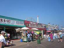
Currently, Coney Island has two amusement parks — Luna Park and Deno's Wonder Wheel Amusement Park — as well as several rides that are not incorporated into either theme park. Coney Island also has several other visitor attractions and hosts renowned events as well. Coney Island's amusement area is one of a few in the United States that is not mostly owned by any one entity.[21]:153
Rides


The current amusement park contains various rides, games such as skeeball and ball tossing, and a sideshow, including games of shooting, throwing, and tossing skills. The rides and other amusements at Coney Island are owned and managed by several different companies and operate independently of each other. It is not possible to purchase season tickets to the attractions in the area.
Three rides at Coney Island are protected as designated New York City landmarks and are listed in the National Register of Historic Places. These three rides are:
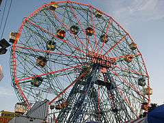
- Wonder Wheel – built in 1918 and opened in 1920, this steel Ferris wheel has both stationary cars and rocking cars that slide along a track. It holds 144 riders, stands 150 ft (46 m) tall, and weighs over 200 tons. At night, the Wonder Wheel's steel frame is outlined and illuminated by neon tubes.[46] It is located at Deno's Wonder Wheel Amusement Park.
- The Cyclone roller coaster – built in 1927, it is one of the United States's oldest wooden coasters still in operation. Popular with roller coaster aficionados, the Cyclone includes an 85 ft (26 m), 60-degree drop. It is owned by the City of New York, and was operated by Astroland, under a franchise agreement. It is now located in and operated by Luna Park.
- Parachute Jump – originally built as the Life Savers Parachute Jump at the 1939 New York World's Fair, this was the first ride of its kind. Patrons were hoisted 190 ft (58 m) in the air before being allowed to drop using guy-wired parachutes. Although the ride has been closed since 1968, it remains a Coney Island landmark and is sometimes referred to as Brooklyn's Eiffel Tower. Between 2002 and 2004, it was completely dismantled, cleaned, painted, and restored, but remains inactive. After an official lighting ceremony in July 2006, the Parachute Jump was slated to be lit year-round using different color motifs to represent the seasons. However, this idea was scrapped when New York City started conserving electricity in the summer months, and it has not been lit regularly since.
Other notable, currently operating attractions include:


- Thunderbolt – In March 2014, construction started on the new Thunderbolt coaster at Coney Island. The Thunderbolt will be manufactured by Zamperla at a cost of US$10 million and will have a 90-degree vertical drop, followed by a 100-foot loop and a zero-gravity roll, along with dives, hills and a corkscrew — all within two minutes. The ride will feature 2,000 feet (610 m) of track, a height of 125 feet (38 m), and a top speed of 65 miles per hour (105 km/h).[47] Thunderbolt will feature three inversions including a vertical loop, corkscrew, and an Immelmann loop.[48][49][50][51] The Thunderbolt, will be located near Surf Avenue and West 15th Street in Coney Island will be constructed with 2,233 feet of track that will stretch to a height of 115 feet and will be built next to the B&B Carousell, an antique merry-go-round that underwent an extensive restoration and reopened last summer. The opening of the Thunderbolt, expected to be by Memorial Day 2014,[52][53] was pushed back to June 6, 2014,[54][55][56] and in early June, it was delayed once again to later in summer 2014.[57] Finally, on June 14, the Thunderbolt was opened.[58]
- B&B Carousell [sic] (as spelled by the frame's builder, William F. Mangels) – this is Coney Island's last traditional carousel, near the old entrance to Luna Park but now surrounded by furniture stores. The carousel is faster than usual, with a traditional roll-operated fairground organ. When the long-term operator died unexpectedly, the carousel was put up for auction, with fears that it would leave Coney Island or be broken up for sale to collectors. However, the City of New York bought the B&B Carousell a few days before the auction; it has since been dismantled, with plans to operate it again in Coney Island in 2013 in a newly constructed carousel pavilion that will be built in Steeplechase Plaza, a 2.2-acre public plaza that is also scheduled to be open for the 2013 season. All the other carousels on Coney Island are kiddie park-style.[59][60] For the restoration, Theresa Rollison, a painter with Carousels and Carvings, custom-mixed more than 80 colors to replicate the original hues. She then applied salmon pink, lemon yellow, metallic silver and maroon, using natural brushes made from badger, squirrel, and hog bristle. “I wouldn’t have chosen to put some of the colors together, but overall it works,” she said.[61] The final part of the restoration was new horsehair tails for the 50 horses, and with that the New York City Economic Development Corp paid $1,700,000 for the restoration.[62] For decades, Coney Island was something of a carousel headquarters. In the late 1800s, carousel makers set up shops there, and by the turn of the century, two dozen merry-go-rounds were operating on the island. There even evolved a Coney Island school of carousel design, distinct from the more staid Philadelphia and County Fair styles. The Coney Island style was characterized by a flamboyant, aggressive-looking horse — neck straining, nostrils flaring, and tongue lolling. The B&B was built in Coney Island, with a frame dating to 1906, and at some point, it operated in New Jersey, although it is unclear for how long. In the early 1920s it received a new set of horses that were carved by Charles Carmel, one of Coney Island’s celebrated carousel makers. It had returned to Brooklyn by 1935.[63][64][65][66]
- Bumper cars – there are three separate bumper car rides on Coney Island, located on 12th street, Deno's Wonder Wheel Park, and Eldorado's Arcade on Surf Avenue.
- Haunted houses – two traditional dark ride haunted houses operate at Coney Island, Spook-a-Rama at Deno's and Ghost Hole on 12th street.

Former rides include:
- Thunderbolt – this roller coaster across the street from Steeplechase Park was constructed in 1925 and closed in 1983. It was torn down by the city "to protect public safety" in 2000 during the construction of nearby Keyspan Park. In the Woody Allen movie Annie Hall, Allen's character's family lives in the small house-like structure under the rear of the roller coaster track.
- Tornado – this roller coaster was constructed in 1926. It suffered a series of small fires which made the structure unstable, and was torn down in 1977.
- Steeplechase Park Horse Race – created by a Coney Island resident George C. Tilyou in 1897, this ride consisted of people riding wooden horses around the park on a steel track.[67]
Beach

Coney Island maintains a broad sandy beach from West 37th Street at Sea Gate, through the central Coney Island area and Brighton Beach, to the beginning of the community of Manhattan Beach, a distance of approximately 2.5 mi (4.0 km). The beach is continuous and is served for its entire length by the broad Riegelmann Boardwalk. A number of amusements are directly accessible from the land-side of the boardwalk, as is the aquarium and a variety of food shops and arcades.
The beach is groomed and replenished on a regular basis by the city. The position of the beach and lack of significant obstructions means virtually the entire beach is in sunlight all day. The beach is open to all without restriction, and there is no charge for use. The beach area is divided into "bays", areas of beach delineated by rock jetties, which moderate erosion and the force of ocean waves.
The Coney Island Polar Bear Club consists of a group of people who swim at Coney Island throughout the winter months, most notably on New Year's Day, when additional participants join them to swim in the frigid waters.
The beach serves as the training grounds for the Coney Island Brighton Beach Open Water Swimmers (CIBBOWS),[68] a group dedicated to promoting open water swimming for individuals of all levels. CIBBOWS hosts several open water swim races each year, such as Grimaldo's Mile and the New York Aquarium 5k, as well as regular weekend training swims.[68]
Other attractions
Nearby, the New York Aquarium, which opened in 1957 on the former site of the Dreamland amusement park, is another attraction on Coney Island. In 2001, KeySpan Park opened on the former site of Steeplechase Park to host the Brooklyn Cyclones minor league baseball team.
Events

The Coney Island Mermaid Parade takes place on Surf Avenue and the boardwalk, and features floats and various acts. It has been produced annually by Coney Island USA, a non-profit arts organization established in 1979, dedicated to preserving the dignity of American popular culture.
Coney Island USA has also sponsored the Coney Island Film Festival every October since 2000, as well as Burlesque At The Beach, and Creepshow at the Freakshow (an interactive Halloween-themed event). It also houses the Coney Island Museum.
The annual Cosme 5K Charity Run/Walk, supported by the Coney Island Sports Foundation (CISF), takes place on the last Sunday of June on the Riegelmann Boardwalk.
In August 2006, Coney Island hosted a major national volleyball tournament sponsored by the Association of Volleyball Professionals. The tournament, usually held on the west coast of the United States, was televised live on NBC. The league built a 4,000-seat stadium and twelve outer courts next to the boardwalk for the event.[69] The tournament returned to Coney Island in 2007 and 2008.
In April 2009, Feld Entertainment, parent company to Ringling Bros. and Barnum & Bailey Circus, announced that "The Greatest Show on Earth" would perform on Coney Island for the entire summer of 2009, the first time since July 16, 1956 that Ringling Bros. had performed in this location. The tents were located between the boardwalk and Surf Avenue, and the show was called The Coney Island Boom-A-Ring. In 2010, they returned to the same location with The Coney Island Illuscination.[70]
Demographics

At the 2000 census, there were 51,205 people living in Coney Island. Of those people, 51.2% were White, 29.3% were Black, 18% were Hispanic or Latino, 3.8% were Asian, 0.5% were Native American, 0.1% were Pacific Islander, 7.6% were some other race, and 3.7% described themselves as two or more races. 70.5% had a high school diploma or higher, and 20.7% had a bachelor's degree or higher. The median household income in 1999 was $21,281.
The neighborhoods on Coney Island, from west to east, are Sea Gate, Coney Island proper, Brighton Beach, and Manhattan Beach. Sea Gate is a private community, one of only a handful of neighborhoods in New York City where the streets are co-owned by the residents and the city. Sea Gate residents pay both, city and Sea Gate taxes. Sea Gate and the Breezy Point Cooperative are the only city neighborhoods cordoned off by a fence and gate houses.
The majority of Coney Island's population resides in approximately thirty 18- to 24-story towers, mostly various forms of public housing. In between the towers are many blocks that were filled with vacant and burned out buildings. Since the 1990s there has been steady revitalization of the area. Many townhouses were built on empty lots, popular franchises opened, and Keyspan Park was built to serve as the home for the Brooklyn Cyclones baseball team. Once home to many Jewish residents, Coney Island's main population groups today are African American, Hispanic, and recent Russian immigrants.
Education
Primary and secondary schools

Coney Island is served by the New York City Department of Education. The Coney Island neighborhood is zoned to PS 90 Edna Cohen School for K-5 education[71][72] PS 329 (K-5), PS 188 The Michael E. Berdy School (K-5), PS 100 Coney Island School (K-5),[73][74] Mark Twain (6–8), IS 303 Herbert S. Eisenberg,[74][75][76] and PS/IS 288 The Shirley Tanyhill School (Pre-K-8) serve Coney Island. In 2006, David Scharfenberg of The New York Times said, "Coney Island’s elementary schools are a mixed lot, with only some exceeding citywide averages on the state’s testing regimen."[74]
There are no zoned high schools, though Abraham Lincoln High School, an academic high school, is in Coney Island.[74][77] Rachel Carson High School for Coastal Studies is located in Coney Island.[78] Nearby high schools include:
- John Dewey High School
- The Leon M. Goldstein High School for the Sciences
- William E. Grady Vocational High School
- The High School Of Sports Management
- Liberation High School
- Mark Twain Intermediate School for the Gifted and Talented
Public libraries

Brooklyn Public Library (BPL) operates the Coney Island Library. It opened in 1911 as an unmanned deposit station. In 1921 it moved to the former Coney Island Times offices and became fully staffed. In 1954 another branch was built. BLP stated that the library was referred to as "the first-ever library built on stilts over the Atlantic Ocean."[79]
Transportation
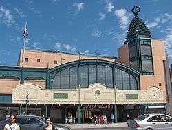
Coney Island's main subway stop is Coney Island – Stillwell Avenue and is served by the D F N Q trains. The terminal is the largest elevated metro station in North America and one of the largest elevated metro stations in the world, with eight tracks serving four platforms in the station. The entire station was rebuilt in 2002–2004.
The bus terminal beneath the station serves the B68 to Prospect Park, the B74 to the Coney Island/Sea Gate border, the B64 to Bay Ridge, and the B82 to Starrett City. The B36 runs from the Sea Gate border at West 37th Street to Nostrand Avenue at Avenue U in Sheepshead Bay, Brooklyn. The X28 provides express bus service to Manhattan on weekdays.
The three main west-east arteries in the Coney Island community, are, from north to south, Neptune Avenue (which crosses travels through Brighton Beach before becoming Emmons Avenue at Sheepshead Bay), Mermaid Avenue, and Surf Avenue (which becomes Ocean Parkway and then runs north toward Prospect Park). The cross streets in the Coney Island neighborhood proper are numbered with "West" prepended to their numbers, running from West 1st Street to West 37th Street at the border of Sea Gate (except for Cropsey Avenue, which becomes West 17th Street south of Neptune Avenue).
The Ocean Parkway bicycle path, the oldest designated bicycle path in the United States, terminates in Coney Island. The Shore Parkway bikeway runs east along Jamaica Bay, and west and north along New York Harbor. Street bike lanes are marked in Neptune Avenue and other streets in Coney Island.
Coney Island is expected to be served by the Citywide Ferry Service[80] at a date not yet determined.[81][82]
In popular culture
Coney Island has been featured in many films, television shows, cartoons, and theatrical plays.[83][84][85][86]
References
Notes
- ↑ JONAH OWEN LAMB (August 6, 2006). "The Ghost Ships of Coney Island Creek". The New York Times. Retrieved June 11, 2014.
- ↑ "Coney Island" (PDF). Retrieved March 1, 2014.
- ↑ Brooklyn before the bridge: American paintings from the Long Island Historical Society, Long Island Historical Society, Brooklyn Museum Brooklyn Museum – 1982, page 54
- ↑ Evan T. Pritchard, Native New Yorkers: The Legacy of the Algonquin People of New York, Council Oak Books – 2002, page 105
- ↑ Evan T. Pritchard, Native New Yorkers: The Legacy of the Algonquin People of New York, Council Oak Books - 2002, page 106
- ↑ Douglass, Harvey (1933). "Coney Island Scenes Shift, Never Change". The Brooklyn Daily Eagle (online, 23 March). Retrieved March 23, 2016.
- 1 2 3 "American Experience — Coney Island Gets a Name". pbs.org.
- ↑ Robert Morden, "A Map of ye English Empire in the Continent of America", 1690. Coney Island is labelled "Conney Ifle". Image of Morden map at SUNY Stony Brook.
- ↑ Henry Popple, "A Map of the British Empire in America", Sheet 12, 1733. Coney Island is labelled "Coney Island". Image of Popple Map can be found at David Rumsey Map Collection Archived October 24, 2012, at the Wayback Machine.
- ↑ John H. Eddy, "Map Of The Country Thirty Miles Round the City of New York", 1811. Coney Island is labeled "Coney I." Image of Eddy Map can be found at David Rumsey Map Collection Archived October 24, 2012, at the Wayback Machine..
- ↑ Sijs van der, Nicoline (2009). Cookies, Coleslaw, and Stoops: The Influence of Dutch on the North American Languages. p. 51. ISBN 978-9089641243.
- ↑ "The Atlantic World: Dutch Place Names". The Dutch in America, 1609-1664. The Library of Congress. Retrieved 10 May 2016.
- 1 2 3 "American Experience. Coney Island. People & Events". PBS. Retrieved November 13, 2015.
- ↑ Berman, J.S.; York, Museum of the City of New (2003). Coney Island. Portraits of America. Barnes and Noble Books. ISBN 978-0-7607-3887-0. Retrieved November 13, 2015.
- 1 2 3 4 5 6 7 Stanton, Jeffrey (1997). "Coney Island — Luxury Hotels". Coney Island History Site. Retrieved November 12, 2015.
- ↑ Weinstein, Stephen (2000). "Brighton Beach". In Jackson, Kenneth T.; Keller, Lisa; Flood, Nancy. The Encyclopedia of New York City (2nd ed.). New York, NY, and New Haven, CT, USA: The New York Historical Society and Yale University Press. pp. 139–140. ISBN 0-300-11465-6. Retrieved November 11, 2015.
- 1 2 Williams, Keith. "Brighton Beach: Old World mentality, New World reality". The Weekly Nabe. Retrieved July 29, 2012.
- 1 2 3 4 Feinman, Mark S. (February 17, 2001). "Early Rapid Transit in Brooklyn, 1878–1913". nycsubway.org. Retrieved November 12, 2015.
- 1 2 3 "The Upper-Class Brooklyn Resorts of the Victorian Era". Curbed NY. June 27, 2013. Retrieved November 12, 2015.
- ↑ http://query.nytimes.com/gst/abstract.html?res=9502E2D71F3DE633A25750C1A9619C946797D6CF
- 1 2 3 4 5 6 7 8 9 10 11 12 13 14 15 Judith N. DeSena; Timothy Shortell (2012). The World in Brooklyn: Gentrification, Immigration, and Ethnic Politics in a Global City. Lexington Books. pp. 147–176. ISBN 978-0-7391-6670-3.
- ↑ David A. Sullivan. "Coney Island History: How 'West Brighton' became Modern-day Coney Island". heartofconeyisland.com. Retrieved November 19, 2016.
- ↑ "Coney - Carousel List". Westland Network. 1997-08-27. Retrieved 2015-11-13.
- ↑ David A. Sullivan. "Coney Island History: The Elephant Hotel and Roller Coaster (1885-1896)". www.heartofconeyisland.com. Retrieved November 19, 2016.
- ↑ Coney Island History Project, “The Face Of Steeplechase” Opening May 24 at the Coney Island History Project Monday, May 19th, 2014
- 1 2 Matus, Paul. "The New BMT Coney Island Terminal". The Third Rail Online. Retrieved August 29, 2007.
- ↑ Caro, R.A. (1974). The Power Broker: Robert Moses and the Fall of New York. A borzoi book. Alfred A. Knopf. Retrieved 2015-11-13.
- ↑ Matassa, Elizabeth (2003). "WHADDYA WANT? IT'S CONEY ISLAND!: TOURISM, PLAY AND MEMORY IN THE ILLEGIBLE CITY" (PDF). University of Delaware. Retrieved 2015-11-13.
- ↑ Amusing the Zillion, Video & Photos of the Day: Riding Coney Island’s Abandoned Giant Slide (1973) February 8, 2015
- ↑ Farrell, Bill (1998-01-21). "BASEBALL PITCH BACK IN SPORTSPLEX MIX RALLY FOR CONEY VENUE". NY Daily News. Retrieved 2015-11-13.
- ↑ Martin, Douglas (1998-11-23). "Back to the Drawing Board in Coney Island". The New York Times. Retrieved 2015-11-13.
- 1 2 Fung, Amanda (2009-06-28). "Coney Island keeper". Crain's New York Business. Retrieved 2015-11-14.
- ↑ 1.5 Billion Development Plan For Coney Island Publication: The New York Sun Date: November 13, 2006
- ↑ "Imagineconey". Imagineconey. Retrieved August 13, 2012.
- ↑ "New York City Department of City Planning — Amanda M. Burden, Director". Nyc.gov. Retrieved August 13, 2012.
- ↑ "Coney Island amusement park closing: News & Videos about Coney Island amusement park closing — CNN iReport". Ireport.com. Retrieved March 17, 2010.
- ↑ "Uniform Land Use Review Procedure (ULURP) – New York City Department of City Planning". Nyc.gov. Archived from the original on July 19, 2012. Retrieved August 13, 2012.
- ↑ See Bloomberg News, November 29, 2006.
- ↑ http://www.allmediany.com/scroll_article.php?scr_id=14
- ↑ "Plans Coming Together For Coney Island Amusement Park Expansion" Archived October 8, 2007, at the Wayback Machine., NY1, November 14, 2006
- ↑ "Archived copy". Archived from the original on July 3, 2009. Retrieved 2009-06-17. Planning Commission Approves Unloved Coney Plan: The Village Voice: 6/17/09
- ↑ Calder, Rich (September 5, 2007). "Ride Over for Coney Classics". New York Post. Retrieved September 5, 2007.
- ↑ "Coney Island gets first new roller coasters in 80 years". Reuters.
- ↑ Nathan's to recover Brooklyn Daily
- ↑ "Despite Sandy's Wrath, Coney Island's Luna Park To Reopen On Schedule Sunday". CBS News New York. Retrieved March 22, 2013.
- ↑ "Deno's Wonder Wheel".
- ↑ NYCEDC Announces New "Thunderbolt" Roller Coaster to be Built at Coney Island Archived March 11, 2014, at the Wayback Machine.
- ↑ Marden, Duane. "Thunderbolt (Luna Park)". Roller Coaster DataBase. Retrieved November 16, 2013.
- ↑ luna-park-breaks-ground-on-new-roller-coaster-the-thunderbolt-on-coney-island
- ↑ New Roller Coaster Promises Coney Island a Return of Thrills
- ↑ coney-islands-luna-park-to-get-new-roller-coaster
- ↑ Originally built in 1906 – Restored B&B Carousell, Coney Island
- ↑ "Coming Soon! The Thunderbolt". Official Website of Luna Park. Retrieved January 10, 2014.
- ↑ "Memorial Day kicks off summer with a splash". NY Daily News.
- ↑ "News and Rumors — Luna Park". Screamscape.com. Retrieved May 27, 2014.
- ↑ Anthony Bell (June 3, 2014). "New Thunderbolt Roller Coaster to Open Friday in Coney Island". ALL MEDIA NY. Retrieved June 4, 2014.
- ↑ Kensinger, Nathan (June 5, 2014). "Change Comes Once Again for Coney Island's Thunderbolt". Curbed NY. Retrieved June 10, 2014.
- ↑ Brown, Stephen R. (June 14, 2014). "Coney Island's new Thunderbolt roller coaster officially opens". NY Daily News. Retrieved June 29, 2014.
- ↑ "Coney Island". NYCEDC.
- ↑ "City breaks ground on Coney Island's Steeplechase Plaza". NY Daily News.
- ↑ "Coney Island’s historic B&B Carousell is open to the public after a mammoth five year restoration", The New York Times
- ↑ "Historic Coney Island Carousel Spins Once Again".
- ↑ "NY1 Exclusive: Historic Carousel Is Jewel Of New Coney Island Park".
- ↑ "Visiting NYC's Coney, Rockaway beaches post-Sandy". Yahoo News. June 20, 2013.
- ↑ "Nathan's, aquarium, B & B Carousell, and Brooklyn Nets store open in Coney". Brooklyn Daily.
- ↑ "Forgotten Tour 10, Coney Island, Brooklyn".
- ↑ "Roller Coasters, Theme Parks, Thrill Rides".
- 1 2 "Coney Island Brighton Beach Open Water Swimmers (CIBBOWS)".
- ↑ "CONEY ISLAND ON THE BALL. Beach volleyball is hitting New York ...& the boardwalk is the place to be". NY Daily News. Retrieved 2016-01-20.
- ↑ The Planet, D (May 1, 2011). "Coney Island — Park, Ferris Wheel, Sight seeing". Retrieved June 2, 2014.
- ↑ Tartar, Andre. "Teacher Exodus at Coney Island School Where Principal Banned ‘God Bless the USA’." New York Magazine. August 19, 2012. Retrieved on October 17, 2012.
- ↑ "PS 90, New York City Schools portal". November 20, 2014.
- ↑ "Home." PS 100 The Coney Island School. Retrieved on October 17, 2012.
- 1 2 3 4 Scharfenberg, David. "Safety Belts On? Renewal Has Its Hazards." The New York Times. November 19, 2006. "Coney Island, which has a residential population of about 53,000, is bounded by the Belt Parkway to the north, Ocean Parkway to the east and the Atlantic Ocean to the south." – Map, Archive
- ↑ Hughes, C. J. "Waterfront Living That Doesn’t Break the Bank." The New York Times. April 30, 2010. p.2. Retrieved on October 15, 2012.
- ↑ "Home." I.S. 303 Herbert S. Eisenberg. Retrieved on October 17, 2012. "501 WEST AVENUE, BROOKLYN, NY 11224"
- ↑ "Home." Abraham Lincoln High School. Retrieved on October 17, 2012. "2800 OCEAN PARKWAY, BROOKLYN, NY 11235"
- ↑ "Teachers Boycott Hs To Protest An Arrest." New York Daily News. Wednesday May 3, 2007. Retrieved on October 11, 2012.
- ↑ "Coney Island Library." Brooklyn Public Library. Retrieved on October 17, 2012.
- ↑ DNAinfoNewYork. "Proposed Routes for NYC's Expanded Ferry Service". Scribd. Retrieved September 22, 2016.
- ↑ "Citywide Ferry Service to Launch in June 2017, Official Says". DNAinfo New York. 2016-03-03. Retrieved 2016-09-22.
- ↑ "New York City's Ferry Service Set to Launch in 2017". NBC New York. Retrieved 9 May 2016.
- ↑ List of mentions at Google Books.
- ↑ "Coney Island: The People's Playground," by Michael Immerso.
- ↑ Immerso, Michael (2002). Coney Island: the people's playground (illustrated ed.). Rutgers University Press. p. 176. ISBN 978-0-8135-3138-0.
- ↑ Rabinovitz, Lauren (2004). "The Coney Island Comedies". In Charlie Keil, Shelley Stamp. American cinema's transitional era: audiences, institutions, practices (illustrated ed.). University of California Press. ISBN 978-0-520-24027-8.
Sources
- Rem Koolhaas, Delirious New York: A retroactive Manifesto for Manhattan (Academy Editions, London, 1978; republished, The Monacelli Press, 1994 — a large part of the book focuses on Coney Island amusement parks)
- John F. Kasson, Amusing The Million: Coney Island at the Turn of the Century (Hill and Wang, New York, 1978; Distributed in Canada by Douglas and McIntyre Ltd.)
- Charles Denson, Coney Island: Lost and Found (Ten Speed Press, 2002)
- Coney Island, a 1991 documentary film by Ric Burns for American Experience
- Townsend Percy (1880), Percy's Pocket dictionary of Coney Island, New York: E. Leypoldt, OCLC 5926329
- J. Perkins Tracy (1887), The tourists companion and guide to Coney Island, Fort Hamilton, Bath Beach, Sheepshead Bay, Rockaway Beach and Far Rockaway, New York: Austin Publishing Co.
Further reading
- The Comprehensive History of Coney Island at Heart of Coney Island
- Coney Island History Articles
- Bland as Sand: Developers Stalk Coney Island, The Indypendent
- Gritty and Trashy... That’s Why I Love It, The Indypendent
- Bruce, Jeannette. "Where The Fun Was," Sports Illustrated, August 28, 1967
- Coney Island History Project
- 1911 Britannica article
External links
| Wikivoyage has a travel guide for Brooklyn/Coney Island and Brighton Beach. |
-
 Media related to Coney Island, Brooklyn at Wikimedia Commons