Watoga, West Virginia
| Watoga, West Virginia | |
|---|---|
| Unincorporated community | |
 Watoga, West Virginia  Watoga, West Virginia | |
| Coordinates: 38°08′44″N 80°09′04″W / 38.14556°N 80.15111°WCoordinates: 38°08′44″N 80°09′04″W / 38.14556°N 80.15111°W | |
| Country | United States |
| State | West Virginia |
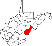
| County | Pocahontas |
| Elevation | 2,113 ft (644 m) |
| Time zone | Eastern (EST) (UTC-5) |
| • Summer (DST) | EDT (UTC-4) |
| Area code(s) | 304 & 681 |
| GNIS feature ID | 1555926[1] |
Watoga is an unincorporated community in Pocahontas County, West Virginia, United States. Watoga is located on the east bank of the Greenbrier River 3.5 miles (5.6 km) east-northeast of Hillsboro.
Watoga is a name derived from a Native American language (possibly Cherokee).[2]
References
- ↑ U.S. Geological Survey Geographic Names Information System: Watoga, West Virginia
- ↑ Kenny, Hamill (1945). West Virginia Place Names: Their Origin and Meaning, Including the Nomenclature of the Streams and Mountains. Piedmont, WV: The Place Name Press. p. 661.
This article is issued from Wikipedia - version of the 7/28/2016. The text is available under the Creative Commons Attribution/Share Alike but additional terms may apply for the media files.