U.S. Route 6 in Nevada
| ||||
|---|---|---|---|---|
| Grand Army of the Republic Highway | ||||
_map.svg.png) | ||||
| Route information | ||||
| Maintained by NDOT | ||||
| Length: | 305.647 mi[1] (491.891 km) | |||
| Existed: | 1937 – present | |||
| Major junctions | ||||
| West end: |
| |||
|
| ||||
| East end: |
| |||
| Highway system | ||||
| ||||

In the U.S. state of Nevada, U.S. Route 6 (US 6) cuts across the middle portion of the state, serving the cities of Tonopah and Ely, en route to Utah and points further east.
The entire highway in Nevada is designated as part of the Grand Army of the Republic Highway.
Route description
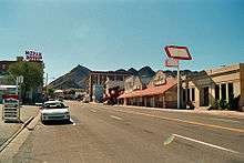
US 6 enters Nevada near the town of Benton, where it is signed east–west for the first time on its journey. The route follows the Midland Trail for much of its length across central Nevada. Shortly after entering Nevada, it climbs Montgomery Pass and then descends into Coaldale, where it meets US 95. The two routes run concurrently for 41 miles (66 km) until Tonopah, where US 95 splits southward towards Las Vegas. US 6 then heads eastward towards Ely.
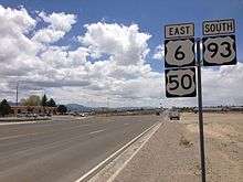
There are no services anywhere between Tonopah and Ely (a distance of about 168 miles), and although US 50 has the nickname "The Loneliest Road in America", US 6 has a solid case for the title, as Tonopah and Ely are the only cities it goes through in the 306 miles (492 km) it traverses in Nevada. In addition, there is not much traffic for US 6, as it ends 38 miles (61 km) south of the California/Nevada border in the small town of Bishop, CA (with connections to the former western terminus of US 6 in Los Angeles). The most heavily traveled portion of US 6 is the portion that is concurrent with US 95, as the latter route connects Las Vegas and Reno, the two largest metropolitan areas in Nevada. Upon reaching Ely, US 6 Business branches off into the central business district before meeting US 50 and US 93. The three routes run southeast out of town for 26 miles (42 km) until Majors Place, where US 93 splits off southward towards Interstate 15 and Las Vegas. US 6 and US 50 both spend the last 37 miles (60 km) running concurrently into Utah.
History
US 6 was one of the original U.S. highways in the 1925 Bureau of Public Roads plan.[2] It was commissioned in 1926, but was not extended west into Nevada until 1937. The alignment of US 6 in Nevada has remained largely unchanged since then.
US 6 was routed entirely over existing state highways in Nevada as follows:
- California state line west of Montgomery Pass to Basalt, concurrently routed with State Route 10
- Basalt to Coaldale, concurrently routed with State Route 15
- Coaldale to Tonopah, concurrently routed with State Route 3
- Tonopah to Ely, concurrently routed with State Route 4 (also called the Midland Trail).
- Ely to present-day Major's Place, concurrently routed with US 93 and State Route 7
- Major's Place to the Utah state line southeast of Baker, concurrently routed with State Route 14
All of the concurrent state routes were removed from US 6 by 1939 except for SR 3 between Coaldale and Tonopah. Also, US 6 was realigned to enter Utah north of Baker instead of passing through the town. In 1940, SR 3 was replaced by US 95 between Coaldale and Tonopah. In 1954, US 50 was realigned between Ely and the Utah border and was concurrently routed over US 6.
Major intersections
- Note: Mileposts in Nevada reset at county lines; the start and end mileposts for each county are given in the county column.
| County | Location | mi[3] | km | Destinations | Notes |
|---|---|---|---|---|---|
| Mineral 0.00–15.20 | | 0.00 | 0.00 | ||
| Basalt | |||||
| Esmeralda 0.00–57.74 | | ||||
| | |||||
| Coaldale | West end of US 95 overlap | ||||
| | |||||
| Nye 0.00–132.02 | Tonopah | East end of US 95 overlap | |||
| | |||||
| Warm Springs | |||||
| Currant | |||||
| White Pine 0.00–101.88 | | ||||
| Ely | 37.96 | 61.09 | West end of US 50 & US 93 overlap | ||
| | Old SR 486 | Serves Cave Lake State Park | |||
| Majors Place | East end of US 93 overlap | ||||
| | |||||
| | Serves Great Basin National Park | ||||
| | 101.88 | 163.96 | |||
1.000 mi = 1.609 km; 1.000 km = 0.621 mi
| |||||
See also
 Nevada portal
 U.S. Roads portal
References
- ↑ Nevada Department of Transportation (January 2013). "State Maintained Highways of Nevada: Descriptions and Maps". Retrieved January 26, 2013.
- ↑ Droz, Robert V. (2007). "U.S. Highways from U.S. 1 to (U.S. 830)". us-highways.com. Retrieved 2008-01-28.
- ↑ Nevada Department of Transportation (May 2008). Maps of Milepost Location on Nevada's Federal and State Highway System by County (PDF). Archived (PDF) from the original on August 10, 2009. Retrieved 2009-09-10.
- Official Road Map of the State of Nevada (Map). State of Nevada – Department of Highways. 1937.
- Official Road Map of the State of Nevada (Map). State of Nevada – Department of Highways. 1939.
- Official Road Map of the State of Nevada (Map). State Highway Department. 1940.
- Official Highway Map of Nevada (Map). Nevada Department of Highways. 1954.
External links
 Media related to U.S. Route 6 in Nevada at Wikimedia Commons
- AARoads: U.S. Highway 6 – Nevada
| Previous state: California |
Nevada | Next state: Utah |
