U.S. Route 95 in Nevada
| ||||
|---|---|---|---|---|
| Veterans Memorial Highway | ||||
_map.svg.png) | ||||
| Route information | ||||
| Maintained by NDOT | ||||
| Length: |
646.71 mi[1] (1,040.78 km) 508.410 miles (818.207 km) independent of other routes[2] | |||
| Existed: | 1940 – present | |||
| Major junctions | ||||
| South end: |
| |||
| North end: |
| |||
| Highway system | ||||
| ||||

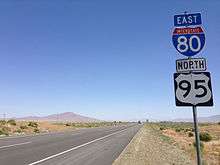
U.S. Route 95 (US 95) is a major U.S. highway traversing the U.S. state of Nevada from north to south directly through Las Vegas and providing connections to both Carson City (via US 50) and Reno (via Interstate 80). US 95 is cosigned with Interstate 80 for 95 miles (153 km) between a junction in Churchill County and Winnemucca before heading north into Oregon at McDermitt.
Along much of its course through Nevada, US 95 has signs designating it as the Veterans Memorial Highway. A portion of the route in Las Vegas northwest of downtown is also called the Oran K. Gragson Freeway, named for the Las Vegas mayor who advocated for construction of that portion of freeway in the 1960s.
Route description
U.S. Route 95 enters Nevada near Cal-Nev-Ari in Clark County and heads north towards Railroad Pass, where it meets US 93. The two routes are then cosigned in the Las Vegas area and east of Henderson, Interstate 515 begins. I-515 is cosigned with US 93/95 for its entire route around eastern Las Vegas. The freeway then heads west into downtown Las Vegas, where it intersects Interstate 15. At the Spaghetti Bowl interchange, US 93 follows I-15 northbound and I-515 ends. US 95 heads west, then north at the Rainbow Curve. The freeway portion then ends and then it becomes a brief four-lane divided highway. US 95 exits Clark County and heads into eastern Nye County for 107 miles. It then enters Esmeralda and continues for 44 miles before meeting US 6 in Tonopah, back in Nye County. US 6/95 leave Tonopah, after two miles, enters Esmeralda County again, and heads west for 41 miles (66 km) until Coaldale, where US 6 splits west towards California and its western terminus in Bishop, California. US 95 then heads northwest towards Hawthorne and Schurz, where US 95 Alternate splits west towards US 50, providing an alternate route towards Carson City and Reno. US 95 itself goes north towards Fallon, where it intersects US 50. US 95 meets Interstate 80 and US 95 Alternate about halfway between Lovelock and Fernley. The two routes then run concurrently for 95 miles (153 km) until reaching Winnemucca, where US 95 splits from I-80 and follows Interstate 80 Business into downtown Winnemucca. In downtown Winnemucca, US 95 turns north in the general direction of Paradise Valley, leaving Interstate 80 Business to follow SR 289 east. North of Winnemucca, US 95 meets the eastern terminus of SR 140, which connects to Lakeview (U.S. Route 395) and Klamath Falls, Oregon and the Pacific Northwest. US 95 finally exits Nevada at McDermitt and heads into Oregon.[3]
History
Extension into Nevada
When the original plan for the U.S. highway system was adopted by the American Association of State Highway Officials (AASHO) in 1926, US 95 was one of the routes created. At that time, however, the route only existed in Idaho from the Canadian border near Eastport to Weiser near the Oregon state line.[4][5] A proposal to extend US 95 south to Winnemucca was considered by AASHO in 1937; however, action was deferred due to incomplete sections in Oregon. AASHO reconsidered the idea at its meeting on June 28, 1939, as part of a larger plan to extend the highway south to Blythe, California. This plan was adopted, officially establishing US 95 throughout Nevada effective January 1, 1940.[5][6] The route was marked along several preexisting state highways as follows:[7][8]
- From the Oregon state line at McDermitt, US 95 followed State Route 8 for 74 miles (119 km) to Winnemucca.
- At Winnemucca, the route joined U.S. Route 40 (State Route 1), traveling 131 miles (211 km) southwest via Lovelock to Fernley.
- In Fernley, US 95 followed State Route 2 for 28 miles (45 km) to Fallon (with a short overlap on U.S. Route 50 west of Fallon).
- The highway turned south at Fallon, running 39 miles (63 km) concurrently with the southern segment of State Route 1A to Schurz.
- At Schurz, US 95 was routed along State Route 3, zigzagging 178 miles (286 km) south and east through Hawthorne, Luning, Coaldale, Tonopah and Goldfield (including an overlap with U.S. Route 6 between Coaldale and Tonopah).
- South of Goldfield, the highway overlapped the entire 236 miles (380 km) of State Route 5, traveling southeast through Beatty and Indian Springs to Las Vegas, joining U.S. Route 93/U.S. Route 466 through Henderson to near Boulder City, then splitting from US 93/466 heading south through Searchlight towards the California state line en route to Needles.
The new Nevada portion of US 95 covered a distance of approximately 686 miles (1,104 km). The entire route was on paved roads, except for a small portion of SR 5 between the California state line and Searchlight.[8]
_near_Melarkey_Street_and_Nevada_State_Route_289_(Winnemucca_Boulevard)_in_Winnemucca%2C_Nevada.JPG)
Fallon to Winnemucca realignment
When U.S. Route 95 was designated through Nevada, it avoided using a shorter alignment between Winnemucca and Fallon. The northern segment of State Route 1A had been previously established running north from Fallon to connect with US 40 southwest of Lovelock. At the time, however, this portion of SR 1A was mostly an unimproved road.[8] State Route 1A had been completely paved by 1959,[9] and the US 95 designation was moved over it by 1960. This new alignment eliminated the need to drive west to Fernley and then double back eastward, shortening the highway's length by about 26 miles (42 km).[10]
When US 95 was realigned, the former route via Fernley was redesignated as alternate route. This would be the second highway to bear this designation, as another U.S. Route 95 Alternate had been created between Schurz and Fernley years earlier.[10] The two separate alternate routes would continue to meet in Fernley until circa 1978, when U.S. Route 50 Alternate replaced the section of US 95 Alternate (original US 95) heading east towards Fallon.[11]

Improvements in Las Vegas
When US 95 was extended through the Las Vegas Valley around 1940, it used the existing roadways traversed by State Route 5. Crossing the valley from the southeast, the U.S. highway traveled along Boulder Highway (now SR 582) through Henderson and the town of Whitney. Reaching the city limits of Las Vegas, the road changed names to Fremont Street as it headed into downtown. The route followed Las Vegas Boulevard northward briefly before going west on Bonanza Road (now SR 579). US 95 finally turned northwest on Rancho Drive (now SR 599), which became the Tonopah Highway as it traveled northwest out of the Vegas valley.[2][12] Over the years, this routing of US 95 along city streets would slowly be replaced with newer, high-speed facilities.
%2C_Main_Street.jpg)
Las Vegas Expressway
Elected in 1959, Las Vegas mayor Oran Gragson began advocating for regional street and planning initiatives in the growing Las Vegas Valley.[13] In the early 1960s, Gragson had become instrumentally involved in planning what was then referred to as the "West Fremont Expressway".[14] By 1968, the expressway was beginning to take shape, beginning at Las Vegas Boulevard downtown, interchanging with Interstate 15 and spurring west towards Rancho Drive.[15]
.JPG)
The Las Vegas Expressway was slowly constructed over the next decade, reaching west to Rainbow Boulevard by 1978.[16] A northward extension, linking the expressway to the Tonopah Highway northwest of downtown was completed around 1980.[17] By 1982, US 95 was moved from Rancho Drive to the completed expressway alignment.[18] Also in 1982, as the result of a petition drive, the new US 95 expressway was renamed to the "Oran K. Gragson Expressway" in honor of the four-term mayor.[13] The Nevada Department of Transportation now recognizes this portion of US 95 as the "Oran K. Gragson Freeway".[19]
_in_Las_Vegas%2C_Nevada.jpg)
Henderson spur
The first section of the future I-515 freeway in Las Vegas opened from the east end of the 1968-era Las Vegas Expressway at Las Vegas Boulevard to Charleston Boulevard in 1984. It was extended south to Boulder Highway (at current exit 70) by 1986. US 95 was moved from Las Vegas Boulevard, Fremont Street, and Boulder Highway onto the new freeway at that time. As additional sections of freeway were completed, both US 95 and the concurrently routed US 93 were moved to the new facility. The I-515 designation was added in 1990, but not widely signed until the completion of the entire freeway to just north of Railroad Pass in 1994. The former alignment on Fremont Street and Boulder Highway is now SR 582, though some portions of that route are now being decommissioned by the state and turned over to local entities for maintenance.
In May 2006, a new system (freeway-to-freeway) interchange was completed to replace the former diamond junction at Lake Mead Parkway/SR 564 (formerly known as Lake Mead Drive) and the new I-215/Bruce Woodbury Beltway. A brand new interchange at Galleria Drive (exit 64B) was opened on November 4, 2009, resulting in the renumbering of the existing junction at Sunset Road (from exit 64 to exit 64A).
Major intersections
Note: Mileposts in Nevada reset at county lines. The start and end mileposts for each county are given in the county column.
| County | Location | mi[2] | km | Exit | Destinations | Notes | ||
|---|---|---|---|---|---|---|---|---|
| Clark 0.00–132.14 | | 0 | 0.0 | Continuation into California | ||||
| | 1 | 1.6 | ||||||
| Searchlight | 20 | 32 | ||||||
| | 46 | 74 | ||||||
| Boulder City | 56 | 90 | Interchange; southern end of US 93 overlap | |||||
| Henderson–Las Vegas line | Southern end of freeway; US 95 overlaps with US 93 & I-515 (exits 56 to 76) | |||||||
| Las Vegas | 76 | Northern end of I-515/US 93 overlap; signed as exits 76A (south) and 76B (north) northbound & exits 76A (north) & 76B (south) southbound; I-15 exit 42 | ||||||
| 76C | Martin Luther King, Jr. Boulevard | Southbound exit is part of exit 76B; no northbound access for exit and entrance until March 2017[20] | ||||||
| 77 | ||||||||
| 78 | Valley View Boulevard | Southbound exit is part of exit 79 | ||||||
| 79 | Decatur Boulevard | |||||||
| 80 | Jones Boulevard (SR 596) | |||||||
| 81 | Summerlin Parkway, Rainbow Boulevard (SR 595 south) | Signed as exits 81A (Summerlin Parkway) and exit 81B (Rainbow Boulevard) northbound | ||||||
| 82 | Lake Mead Boulevard | Signed as exits 82A (east) and 82B (west/Rainbow Boulevard) northbound | ||||||
| 83 | Cheyenne Avenue (SR 574 east) | |||||||
| 85 | Craig Road (SR 573 east) | |||||||
| 90A | Southbound exit signed as part of exit 91 | |||||||
| 90B | Ann Road | Southbound exit signed as part of exit 91 | ||||||
| 91 | Centennial Center Boulevard | Southbound exit and entrance | ||||||
| 91 | No southbound exit | |||||||
| 93 | Durango Drive | Also signed southbound as To CC 215 | ||||||
| 95 | Skye Canyon Park Drive | |||||||
| Northern end of freeway | ||||||||
| 92.36 | 148.64 | |||||||
| | 99 | Snow Mountain | Interchange; serves Las Vegas Paiute Indian Reservation | |||||
| | 106.00 | 170.59 | ||||||
| Nye 0.00–107.24 | | 6 | 9.7 | Mercury | Interchange | |||
| | 14 | 23 | ||||||
| Amargosa Valley | 30 | 48 | ||||||
| Beatty | 60 | 97 | ||||||
| | 95 | 153 | ||||||
| Esmeralda 0.00–44.20 | | 4 | 6.4 | |||||
| Nye 151.41–152.63 | Tonopah | 152.63 | 245.63 | Southern end of US 6 overlap | ||||
| Esmeralda 57.74–19 85.40–99.08 | | 25 | 40 | |||||
| Coaldale | 85.40 | 137.44 | Northern end of US 6 overlap | |||||
| Mineral 0.00–92.56 | | 7 | 11 | |||||
| Luning | 25.55 | 41.12 | ||||||
| Hawthorne | 49.00 | 78.86 | Hazardous cargo route around Hawthorne | |||||
| 50 | 80 | |||||||
| 50 | 80 | Hazardous cargo route around Hawthorne | ||||||
| Schurz | 83.16 | 133.83 | ||||||
| Lyon |
No major junctions | |||||||
| Churchill 0.00–59.02 | | 17 | 27 | Pasture Road (SR 120 east) | ||||
| | 21 | 34 | Lone Tree Road (SR 718 west) | |||||
| | 21 | 34 | Berney Road (SR 119 east) | |||||
| | 22 | 35 | Union Lane (SR 720 east) – Naval Air Station Fallon | |||||
| Fallon | 25.07 | 40.35 | ||||||
| 26 | 42 | Southern end of US 50 overlap | ||||||
| Northern end of US 50 overlap | ||||||||
| | Old River Road (SR 726 east) | |||||||
| | 59.02 | 94.98 | Interchange; southern end of I-80 overlap | |||||
| | US 95 overlaps I-80 (exits 83 to 176) | |||||||
| Humboldt 0.00–73.76 | Winnemucca | Interchange; northern end of I-80 overlap | ||||||
| Hanson Street (SR 787 east) | ||||||||
| Paradise Hill | ||||||||
| | ||||||||
| Orovada | ||||||||
| | Continuation into Oregon | |||||||
1.000 mi = 1.609 km; 1.000 km = 0.621 mi
| ||||||||
Special routes
- U.S. Route 95 Alternate, an alternate route beginning in Schurz serving Yerington, Silver Springs and Fernley
- U.S. Route 95 Business, a business route in Las Vegas
- U.S. Route 95 Truck, a truck bypass of Hawthorne
See also
-
 Nevada portal
 -
 U.S. Roads portal
References
- ↑ Federal Highway Administration, National Highway Planning Network GIS data version 2005.08
- 1 2 3 Nevada Department of Transportation (January 2013). "State Maintained Highways of Nevada: Descriptions and Maps". Retrieved January 26, 2013.
- ↑ Google Maps street maps and USGS topographic maps, accessed December 2007 via ACME Mapper
- ↑ Droz, Robert V. (28 Feb 2005). "US Highways in 1927". U.S. Highways: from US 1 to (US 830). Retrieved 19 Feb 2010.
- 1 2 "U.S. 95 and Idaho's North and South Highway". Highway History. Federal Highway Administration. 17 Oct 2008. Retrieved 20 March 2010.
- ↑ Droz, Robert V. (15 July 2009). "North–South U.S. Highways from US 1 to US 101". U.S. Highways: from US 1 to (US 830). Retrieved 20 Feb 2010.
- ↑ Official Road Map of the State of Nevada (Map) (1939 ed.). Nevada Department of Highways. Retrieved 19 Feb 2010.
- 1 2 3 Official Road Map of the State of Nevada (Map) (1940 ed.). Nevada Department of Highways. Retrieved 19 Feb 2010.
- ↑ Official Highway Map of Nevada (Map) (1959 ed.). Nevada Department of Highways. § D2. Retrieved 21 Feb 2010.
- 1 2 Official Highway Map of Nevada (Map) (1960 ed.). Nevada Department of Highways. § D2. Retrieved 21 Feb 2010.
- ↑ Official Highway Map of Nevada (Map) (1978-79 ed.). Nevada State Highway Department. 1978. § C1-C2. Retrieved 21 Feb 2010.
- ↑ General Highway Map – Clark County, Nevada (Map). Nevada Department of Highways. 1952. Retrieved 24 March 2010. ("Clark County 1952 004" ZIP file contains map image.)
- 1 2 "Gragson, Las Vegas' longest-serving mayor, dies". Las Vegas Sun. Greenspun Media Group. 8 October 2002. Retrieved 24 March 2010.
- ↑ Evans, K.J. "Oran K. Gragson: Mayor Who Made His Mark". Las Vegas Review Journal – The First 100. Stephens Press. Retrieved 24 March 2010.
- ↑ General Highway Map – Las Vegas Quadrangle, Nevada (PDF) (Map). Nevada Department of Highways. 1968. Retrieved 26 March 2011.
- ↑ Official Highway Map of Nevada (Map) (1978-79 ed.). Nevada State Highway Department. 1978. Las Vegas Region inset. Retrieved 24 March 2010.
- ↑ Official Highway Map of Nevada (Map) (1980-81 ed.). Nevada Department of Transportation. 1980. Las Vegas Region inset. Retrieved 24 March 2010.
- ↑ Official Highway Map of Nevada (Map). Nevada Department of Transportation. 1982. Las Vegas Region inset. Retrieved 24 March 2010.
- ↑ Named Highways of Nevada (PDF) (Map). Nevada Department of Transportation. 2008. Retrieved 26 March 2011.
- ↑ Marroquin, Art (October 31, 2016). "Car-nado cluster avoided as Las Vegas motorists heed closure warnings". Las Vegas Review-Journal. Retrieved November 16, 2016.
| Wikimedia Commons has media related to U.S. Route 95 in Nevada. |
| Previous state: California |
Nevada | Next state: Oregon |