Benton, California
| Benton | |
|---|---|
| Census designated place | |
|
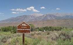
Benton Hot Springs and White Mountains | |
 Benton Location in California | |
| Coordinates: 37°49′09″N 118°28′35″W / 37.81917°N 118.47639°WCoordinates: 37°49′09″N 118°28′35″W / 37.81917°N 118.47639°W | |
| Country |
|
| State |
|
| County | Mono |
| Area[1] | |
| • Total | 28.503 sq mi (73.823 km2) |
| • Land | 28.483 sq mi (73.771 km2) |
| • Water | 0.020 sq mi (0.052 km2) 0.07% |
| Elevation[2] | 5,387 ft (1,642 m) |
| Population (April 1, 2010) | |
| • Total | 280 |
| • Density | 9.8/sq mi (3.8/km2) |
| Time zone | Pacific (UTC-8) |
| • Summer (DST) | PDT (UTC-7) |
| ZIP code | 93512 |
| Area codes | 442/760 |
| GNIS feature IDs | 256836, 2582943 |
| [2] [3] | |
Benton (formerly, Benton Station) is a census-designated place[4] in Mono County, California, United States.[2] It is located 3 miles (4.8 km) east-northeast of the community of Benton Hot Springs and 32 miles (51 km) north of the community of Bishop, at an elevation of 5387 feet (1642 m).[2] The population was 280 at the 2010 census, up from 196 reported at 2000 by Mono County.[5]
Benton is in area codes 442 and 760 and ZIP code 93512. It is also known as Benton Hot Springs because of the hot springs it features. Benton was once a small mining town with up to 5,000 inhabitants. Many of the original buildings still remain, but the town has never completely died.[6] The 160 acre (65 hectare) Benton Paiute reservation is in the vicinity with about 50 full-time residents.[7]
History
Benton is one of the oldest existing towns in Mono County. Benton was originally founded by the western Indians who came to make use of its hot springs. As the nearby towns of Bodie and Aurora grew in size and population, Benton soon became a check-point for travelers on the way south in 1852.[8]
Gold was discovered in the hills of Benton in 1862, and its population quickly grew. After hitting the initial strike of gold, not much more was found, but Benton's profits were soon primarily from silver. Unlike other mining towns, Benton was able to provide enough for the town to thrive and flourish for approximately 50 years. Although most mining activity occurred between 1862 and 1890, the town never completely collapsed.[8]
The Carson and Colorado Railroad reached Benton in 1883.[9]
Location
Benton lies along U.S. Route 6, outside of Bishop, enroute to remote areas of Nevada. The terrain is described as high desert at an elevation of 5,377 feet (1,639 m) above sea level.[10]
Although Benton is a small town, it is surrounded by other small towns and cities including Mammoth Lakes, Bishop, Death Valley, Lee Vining, June Lake, Tom's Place, Crowley Lake, and Convict Lake.[10]
The Nevada state line is about 6 miles (10 km) northeast of Benton. US Route 6 crosses this border, then climbs over 7,150 ft. (2,180m) Montgomery Pass at the northern end of the White Mountains. Benton has excellent views of 13,141 ft. (4,006m) Boundary Peak, Nevada's highest, and 13,441 ft. (4,097m) Montgomery Peak just inside California.
Geography
According to the United States Census Bureau, the CDP covers an area of 28.5 square miles (73.8 km²), 99.93% of it land, and 0.07% of it water.
Climate
| Climate data for Benton Inspection Station | |||||||||||||
|---|---|---|---|---|---|---|---|---|---|---|---|---|---|
| Month | Jan | Feb | Mar | Apr | May | Jun | Jul | Aug | Sep | Oct | Nov | Dec | Year |
| Record high °F (°C) | 94 (34) |
69 (21) |
98 (37) |
84 (29) |
96 (36) |
99 (37) |
104 (40) |
101 (38) |
98 (37) |
88 (31) |
72 (22) |
95 (35) |
104 (40) |
| Average high °F (°C) | 53.9 (12.2) |
54.3 (12.4) |
62.4 (16.9) |
68.3 (20.2) |
79.7 (26.5) |
88.7 (31.5) |
92.4 (33.6) |
93.4 (34.1) |
86.1 (30.1) |
70.3 (21.3) |
59.3 (15.2) |
53.3 (11.8) |
71.84 (22.15) |
| Average low °F (°C) | 21.7 (−5.7) |
21.1 (−6.1) |
25.9 (−3.4) |
31.6 (−0.2) |
40.4 (4.7) |
46.5 (8.1) |
51.8 (11) |
51.6 (10.9) |
43.0 (6.1) |
32.2 (0.1) |
25.2 (−3.8) |
19.6 (−6.9) |
34.22 (1.23) |
| Record low °F (°C) | 4 (−16) |
5 (−15) |
10 (−12) |
17 (−8) |
19 (−7) |
34 (1) |
41 (5) |
34 (1) |
30 (−1) |
16 (−9) |
3 (−16) |
9 (−13) |
3 (−16) |
| Average precipitation inches (mm) | 1.08 (27.4) |
1.22 (31) |
0.89 (22.6) |
0.35 (8.9) |
0.42 (10.7) |
0.39 (9.9) |
0.47 (11.9) |
0.44 (11.2) |
0.31 (7.9) |
0.30 (7.6) |
0.66 (16.8) |
0.98 (24.9) |
7.51 (190.8) |
| Average snowfall inches (cm) | 4.9 (12.4) |
2.2 (5.6) |
1.3 (3.3) |
0.6 (1.5) |
0.3 (0.8) |
0.0 (0) |
0.0 (0) |
0.0 (0) |
0.0 (0) |
0.0 (0) |
1.3 (3.3) |
3.0 (7.6) |
13.6 (34.5) |
| Source: [11] | |||||||||||||
Demographics
The 2010 United States Census[12] reported that Benton had a population of 280. The population density was 9.8 people per square mile (3.8/km²). The racial makeup of Benton was 199 (71.1%) White,0 (0.4%) African American, 37 (21.1%) Native American, 1 (0.4%) Asian, 0 (0.0%) Pacific Islander, 15 (5.4%) from other races, and 5 (1.8%) from two or more races. Hispanic or Latino of any race were 38 persons (13.6%).
The Census reported that 280 people (100% of the population) lived in households, 0 (0%) lived in non-institutionalized group quarters, and 0 (0%) were institutionalized.
There were 122 households, out of which 29 (23.8%) had children under the age of 18 living in them, 59 (48.4%) were opposite-sex married couples living together, 9 (7.4%) had a female householder with no husband present, 7 (5.7%) had a male householder with no wife present. There were 14 (11.5%) unmarried opposite-sex partnerships, and 1 (0.8%) same-sex married couples or partnerships. 40 households (32.8%) were made up of individuals and 10 (8.2%) had someone living alone who was 65 years of age or older. The average household size was 2.30. There were 75 families (61.5% of all households); the average family size was 2.81.
The population was spread out with 54 people (19.3%) under the age of 18, 10 people (3.6%) aged 18 to 24, 58 people (20.7%) aged 25 to 44, 123 people (43.9%) aged 45 to 64, and 35 people (12.5%) who were 65 years of age or older. The median age was 48.8 years. For every 100 females there were 105.9 males. For every 100 females age 18 and over, there were 103.6 males.
There were 159 housing units at an average density of 5.6 per square mile (2.2/km²), of which 86 (70.5%) were owner-occupied, and 36 (29.5%) were occupied by renters. The homeowner vacancy rate was 1.1%; the rental vacancy rate was 15.6%. 191 people (68.2% of the population) lived in owner-occupied housing units and 89 people (31.8%) lived in rental housing units.
Education
Benton is in the Eastern Sierra Unified School District.[13] An elementary school, Edna Beaman Elementary, is located in town. There was a high school, which was closed at the end of the 2011-2012 school year.
Attractions
The hot springs are one of the major attractions in Benton, as well as fine bed and breakfast rooms and overnight soaking tubs. With the abandonment of travelers' services at nearby Montgomery Pass, it offers the only lodging, restaurant and gas station services within a 30 mile (50 km) radius. There are several old mines in the surrounding hills that have also been a source of interest to tourists as well as the hiking and mountain biking trails in the area.[10] Many of the original buildings from the old mine town still exist and are open to exploration, including the cemetery.[6] Benton is a departure point for hiking to Nevada high point Boundary Peak via a (rough) 2WD road to Queen Mine at 9,200 ft (2,800m) or a 4WD extension to Kennedy Saddle at 9,900 ft (3,020m).[14]
References
- ↑ "2010 Census U.S. Gazetteer Files – Places – California". United States Census Bureau.
- 1 2 3 4 "Benton". Geographic Names Information System. United States Geological Survey. Retrieved May 13, 2015.
- ↑ "Benton Census Designated Place". Geographic Names Information System. United States Geological Survey. Retrieved May 13, 2015.
- ↑ U.S. Geological Survey Geographic Names Information System: Benton, California
- ↑ Mono County populations
- 1 2 Benton Hot Springs, retrieved 2008-03-12
- ↑ Barry M Prtitzker (2000) A Native American Encyclopedia. (New York: Oxford University Press), p. 227.
- 1 2 Evans, Cat, Benton, retrieved 2008-03-12
- ↑ Durham, David L. (1998). California's Geographic Names: A Gazetteer of Historic and Modern Names of the State. Clovis, Calif.: Word Dancer Press. p. 1146. ISBN 1-884995-14-4.
- 1 2 3 town.Benton, 1996–2008, retrieved 2008-03-12
- ↑ "BENTON INSPECTION STN, CALIFORNIA (040684)". Western Regional Climate Center. Retrieved June 5, 2016.
- ↑ "2010 Census Interactive Population Search: CA - Benton CDP". U.S. Census Bureau. Retrieved July 12, 2014.
- ↑ Mono County Office of Education
- ↑ http://www.summitpost.org/trip-report/339203/scenic-route-to-boundary-peak.html
Municipalities and communities of Mono County, California, United States | ||
|---|---|---|
| Town | 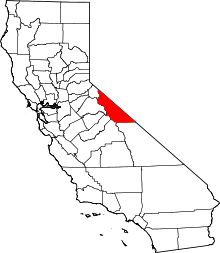 | |
| CDPs | ||
| Unincorporated communities | ||
| Indian reservations | ||
| Former settlements | ||