Taylors Beach, New South Wales
| Taylors Beach New South Wales | |||||||||||||
|---|---|---|---|---|---|---|---|---|---|---|---|---|---|
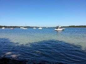 A picture taken of Taylors Beach from the shoreline | |||||||||||||
|
Taylors Beach | |||||||||||||
| Coordinates | 32°45′04″S 152°04′04″E / 32.75111°S 152.06778°ECoordinates: 32°45′04″S 152°04′04″E / 32.75111°S 152.06778°E | ||||||||||||
| Population | 99 (2011 census)[1] | ||||||||||||
| • Density | 18.7/km2 (48/sq mi) | ||||||||||||
| Postcode(s) | 2316 | ||||||||||||
| Elevation | 3 m (10 ft)[Note 1] | ||||||||||||
| Area | 5.3 km2 (2.0 sq mi)[Note 2] | ||||||||||||
| Time zone | AEST (UTC+10) | ||||||||||||
| • Summer (DST) | AEDT (UTC+11) | ||||||||||||
| Location |
| ||||||||||||
| LGA(s) | Port Stephens Council[2] | ||||||||||||
| Region | Hunter[2] | ||||||||||||
| County | Gloucester[3] | ||||||||||||
| Parish | Tomaree[3] | ||||||||||||
| State electorate(s) | Port Stephens[4] | ||||||||||||
| Federal Division(s) | Paterson[5] | ||||||||||||
| |||||||||||||
| |||||||||||||
Taylors Beach is a suburb of the Port Stephens local government area in the Hunter Region of New South Wales, Australia.[2][3] It is largely undeveloped except for some commercial and light industrial developments in the southern part of the suburb The largest population centre is at Taylors Beach itself, in the western part of the suburb, adjacent to Tilligerry Creek and Port Stephens.[7] At the 2011 census Taylors Beach had a population of 99.[1]
Industry
Taylors Beach is home to some big-box stores which include a Bunnings Warehouse, Supercheap Auto, Boating Camping and Fishing and Repco.
Taylors Beach also home to the Port Stephens Fisheries Institute. Which is responsible for Fisheries Research and Compliance. As well as Aquaculture and Aquatic Bio-security.
The institute employs approximately 85 people[8] and is run under the Department of Primary Industries (New South Wales)
Notes
References
- 1 2 Australian Bureau of Statistics (31 October 2012). "Taylors Beach (State Suburb)". 2011 Census QuickStats. Retrieved 23 October 2012.
- 1 2 3 "Suburb Search - Local Council Boundaries - Hunter (HT) - Port Stephens". New South Wales Division of Local Government. Retrieved 15 June 2008.
- 1 2 3 "Taylors Beach". Geographical Names Register (GNR) of NSW. Geographical Names Board of New South Wales. Retrieved 15 June 2008.
- ↑ "Port Stephens". New South Wales Electoral Commission. 24 March 2007. Retrieved 15 June 2008.
- ↑ "Paterson". Australian Electoral Commission. 19 October 2007. Retrieved 15 June 2008.
- 1 2 3 "Nelson Bay (Nelson Head)". Climate statistics for Australian locations. Bureau of Meteorology. Retrieved 15 June 2008.
- ↑ "Taylors Beach". Land and Property Management Authority - Spatial Information eXchange. New South Wales Land and Property Information. Retrieved 15 June 2008.
- ↑ "Port Stephens Fisheries Institute | NSW Department of Primary Industries". www.dpi.nsw.gov.au. Retrieved 2016-11-11.