One Mile, New South Wales
| One Mile New South Wales | |||||||||||||
|---|---|---|---|---|---|---|---|---|---|---|---|---|---|
 Road sign at the northern entrance to One Mile | |||||||||||||
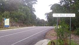 Road signs identifying suburb as both One Mile and (incorrectly) One Mile Beach | |||||||||||||
| Coordinates | 32°46′S 152°6.76′E / 32.767°S 152.11267°ECoordinates: 32°46′S 152°6.76′E / 32.767°S 152.11267°E | ||||||||||||
| Population | 277 (2011 census)[1] | ||||||||||||
| • Density | 58.9/km2 (153/sq mi) | ||||||||||||
| Postcode(s) | 2316 | ||||||||||||
| Area | 4.7 km2 (1.8 sq mi)[Note 1] | ||||||||||||
| Time zone | AEST (UTC+10) | ||||||||||||
| • Summer (DST) | AEDT (UTC+11) | ||||||||||||
| Location |
| ||||||||||||
| LGA(s) | Port Stephens Council | ||||||||||||
| Region | Hunter | ||||||||||||
| County | Gloucester[2] | ||||||||||||
| Parish | Tomaree[2] | ||||||||||||
| State electorate(s) | Port Stephens | ||||||||||||
| Federal Division(s) | Paterson | ||||||||||||
| |||||||||||||
| |||||||||||||
One Mile is a suburb of the Port Stephens local government area in the Hunter Region of New South Wales, Australia.[4] The suburb is semi-rural with a small urban settlement west of Gan Gan Road, a residential park (Middlerock Home Village) and a number of caravan parks to the east of Gan Gan Road. The parks are positioned to provide quick access to the suburb's two beaches.[5]
One Mile Beach, after which the area was named, is a family-friendly surf beach that is popular with tourists while Samurai Beach is clothing optional. Both beaches, like a large percentage of the locality, lie within the Tomaree National Park. The beaches form most of the coastline in Anna Bay which gave the adjacent suburb of Anna Bay its name.[6]
Although the suburb is formally called One Mile residents often refer to it as One Mile Beach. Even some road signs identify the area incorrectly as One Mile Beach.
Notes
- ↑ Area calculation is based on 1:100000 map 9232 NEWCASTLE.
References
- ↑ Australian Bureau of Statistics (31 October 2012). "One Mile (State Suburb)". 2011 Census QuickStats. Retrieved 17 October 2012.
- 1 2 "One Mile (suburb)". Geographical Names Register (GNR) of NSW. Geographical Names Board of New South Wales. Retrieved 31 May 2008.
- 1 2 3 "Nelson Bay (Nelson Head)". Climate statistics for Australian locations. Bureau of Meteorology. Retrieved 2 June 2008.
- ↑ "Suburb Search - Local Council Boundaries - Hunter (HT)". New South Wales Division of Local Government. Retrieved 31 May 2008.
- ↑ "One Mile". Land and Property Management Authority - Spatial Information eXchange. New South Wales Land and Property Information. Retrieved 31 May 2008.
- ↑ "Anna Bay (bay)". Geographical Names Register (GNR) of NSW. Geographical Names Board of New South Wales. Retrieved 31 May 2008.
![]() Media related to One Mile, New South Wales at Wikimedia Commons
Media related to One Mile, New South Wales at Wikimedia Commons
| North of Sydney Harbour |
|
|---|---|
| Within Sydney Harbour | |
| South of Sydney Harbour | |
| |