Mallabula, New South Wales
| Mallabula New South Wales | |||||||||||||
|---|---|---|---|---|---|---|---|---|---|---|---|---|---|
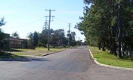 Main road of Mallabula | |||||||||||||
|
Mallabula | |||||||||||||
| Coordinates | 32°44.1′S 152°0.6′E / 32.7350°S 152.0100°ECoordinates: 32°44.1′S 152°0.6′E / 32.7350°S 152.0100°E | ||||||||||||
| Population | 851 (2011 census)[1] | ||||||||||||
| • Density | 315.2/km2 (816/sq mi) [Note 1] | ||||||||||||
| Postcode(s) | 2319 | ||||||||||||
| Elevation | 3 m (10 ft)[Note 2] | ||||||||||||
| Area | 2.7 km2 (1.0 sq mi)[Note 3] | ||||||||||||
| Time zone | AEST (UTC+10) | ||||||||||||
| • Summer (DST) | AEDT (UTC+11) | ||||||||||||
| Location |
| ||||||||||||
| LGA(s) | Port Stephens Council | ||||||||||||
| Region | Hunter | ||||||||||||
| County | Gloucester[2] | ||||||||||||
| Parish | Sutton[2] | ||||||||||||
| State electorate(s) | Port Stephens | ||||||||||||
| Federal Division(s) | Paterson | ||||||||||||
| |||||||||||||
| |||||||||||||
Mallabula is a primarily residential suburb of the Port Stephens local government area in the Hunter Region of New South Wales, Australia. It is located on the Tilligerry Peninsula between Lemon Tree Passage and Tanilba Bay.[4][5] The origin of the name may mean "three swamps" in the local Aboriginal language.[6]
Geography
Mallabula is a low-lying suburb, almost at sea level.Note3 It is bisected by Lemon Tree Passage Road, which stretches for the full length of the peninsula, from Salt Ash in the south-west, to Lemon Tree Passage. In the northern part of the suburb is a small subdivision covering 0.5 square kilometres (0.2 sq mi) on the banks of Tanilba Bay.
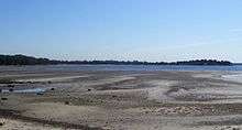
The beach consists mainly of sand flats that are exposed at low tide and almost completely covered at high tide preventing the beach from being useful as either a swimming or surfing beach. Near Rookes Point, at the mouth of Tanilba Bay, the land rises to a height of 9.1 metres (30 ft) AMSL. At the eastern extremity of this area the land reaches a peak of 18.3 m (60 ft) in a heavily forested area. However, between these two points and throughout the remainder of the suburb the land is generally no more than 3 m (10 ft) AMSL and is predominantly sandy.
The land south of Lemon Tree Passage Road is generally uninhabited, occupied only by a handful of homes in a single cul-de-sac and a sewage treatment plant.[5]
Demographics
At the 2011 census Mallabula had a population of 851.[1] Almost all of the population resides in a small, residential subdivision occupying only 18.5% of the entire suburb.[7] The population density in this area is 1,702/km2 (4,410/sq mi). The remaining population resides in four homes in a single cul-de-sac south of Tanilba Bay and is accounted for in the ABS population data for that suburb.[8]
Notes
- ↑ This is the average density of the whole suburb. However, approximately 2.1 km2 (0.8 sq mi) (77.8%) of the suburb is uninhabited or consists of non-residential zones at the edge of the suburb and the average population density in the inhabited portion of the suburb is much higher.
- ↑ Elevation data as shown on 1:100000 map 9232 NEWCASTLE and 1:25000 map 93324S PORT STEPHENS.
- ↑ Area calculation is based on 1:100000 map 9232 NEWCASTLE. The area presented is that of the whole suburb. The residential portion of the suburb is only 0.5 km2 (0.2 sq mi) or 22.2% of the total area.
References
- 1 2 Australian Bureau of Statistics (31 October 2012). "Mallabula (State Suburb)". 2011 Census QuickStats. Retrieved 16 October 2012.
- 1 2 "Mallabula". Geographical Names Register (GNR) of NSW. Geographical Names Board of New South Wales. Retrieved 28 May 2008.
- 1 2 3 "Nelson Bay (Nelson Head)". Climate statistics for Australian locations. Bureau of Meteorology. Retrieved 2 June 2008.
- ↑ "Suburb Search - Local Council Boundaries - Hunter (HT)". New South Wales Division of Local Government. Retrieved 28 May 2008.
- 1 2 "Mallabula". Land and Property Management Authority - Spatial Information eXchange. New South Wales Land and Property Information. Retrieved 28 May 2008.
- ↑ "Townships". Port Stephens Visitor Information Centre. Retrieved 26 January 2013.
- ↑ Australian Bureau of Statistics (31 October 2012). "2011 Community Profiles: Mallabula (State Suburb)". 2011 Census of Population and Housing. Retrieved 16 October 2012.
- ↑ "Tanilba Bay CCD map". 2006 Census QuickStats. Australian Bureau of Statistics. 25 October 2007. Retrieved 28 May 2008.
![]() Media related to Mallabula, New South Wales at Wikimedia Commons
Media related to Mallabula, New South Wales at Wikimedia Commons