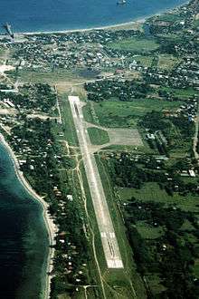
San Fernando Airport (Philippines)
| San Fernando Airport Paliparan ng San Fernando Pagtayaban ti San Fernando | |||||||||||
|---|---|---|---|---|---|---|---|---|---|---|---|
 | |||||||||||
| IATA: SFE – ICAO: RPUS | |||||||||||
| Summary | |||||||||||
| Airport type | Public | ||||||||||
| Operator | Civil Aviation Authority of the Philippines | ||||||||||
| Serves | San Fernando | ||||||||||
| Location | Barangay Poro, San Fernando, La Union | ||||||||||
| Elevation AMSL | 4 m / 13 ft | ||||||||||
| Coordinates | 16°35′44.12″N 120°18′11.59″E / 16.5955889°N 120.3032194°ECoordinates: 16°35′44.12″N 120°18′11.59″E / 16.5955889°N 120.3032194°E | ||||||||||
| Runways | |||||||||||
| |||||||||||
San Fernando Airport (Filipino: Paliparan ng San Fernando, Ilokano: Pagtayaban ti San Fernando) (IATA: SFE, ICAO: RPUS) is an airport serving the general area of San Fernando, located in the province of La Union in the Philippines. The airport is classified as a community airport by the Civil Aviation Authority of the Philippines, a body of the Department of Transportation and Communications that is responsible for the operations of not only this airport but also of all other airports in the Philippines except the major international airports.
It was extensively used as a landing strip by American forces when Wallace Air Station was still in operation.
No airlines currently serve the airport.
External links
This article is issued from Wikipedia - version of the 1/16/2016. The text is available under the Creative Commons Attribution/Share Alike but additional terms may apply for the media files.