Sally Rocks
 Location of Hurd Peninsula on Livingston Island in the South Shetland Islands. | |
| Geography | |
|---|---|
| Location | Antarctica |
| Coordinates | 62°42′08.8″S 60°25′45.7″W / 62.702444°S 60.429361°W |
| Archipelago | South Shetland Islands |
| Administration | |
| Demographics | |
| Population | 0 |
| Additional information | |
| Administered under the Antarctic Treaty System | |
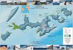
Topographic map of Livingston Island, Greenwich, Robert, Snow and Smith Islands.
Sally Rocks is a small group of rocks trending southwestwards in South Bay just off the west coast of Hurd Peninsula, Livingston Island in the South Shetland Islands, Antarctica.
The feature's name derives from the name 'Sallys Cove' applied in 1820-23 by James Weddell to a cove in the vicinity.
Location
The rocks are centred at 62°42′08.8″S 60°25′45.7″W / 62.702444°S 60.429361°W which is 1.78 km (1.11 mi) south of Salisbury Bluff, 2.04 km (1.27 mi) north of Miers Bluff and 10.82 km (6.72 mi) southeast of Hannah Point (British mapping in 1968, detailed Spanish mapping in 1991, Bulgarian mapping in 2005 and 2009).
See also
- Composite Antarctic Gazetteer
- List of Antarctic islands south of 60° S
- SCAR
- Territorial claims in Antarctica
Maps
- Isla Livingston: Península Hurd. Mapa topográfico de escala 1:25 000. Madrid: Servicio Geográfico del Ejército, 1991.
- L.L. Ivanov et al., Antarctica: Livingston Island and Greenwich Island, South Shetland Islands (from English Strait to Morton Strait, with illustrations and ice-cover distribution), Scale 1: 100000 map, Antarctic Place-names Commission of Bulgaria, Ministry of Foreign Affairs, Sofia, 2005.
- L.L. Ivanov. Antarctica: Livingston Island and Greenwich, Robert, Snow and Smith Islands. Scale 1:120000 topographic map. Troyan: Manfred Wörner Foundation, 2009.
References
External links
This article is issued from Wikipedia - version of the 11/17/2016. The text is available under the Creative Commons Attribution/Share Alike but additional terms may apply for the media files.