Maglizh Rocks
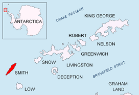 Location of Smith Island in the South Shetland Islands | |
 Maglizh Rocks | |
| Geography | |
|---|---|
| Location | Antarctica |
| Coordinates | 63°01′06″S 62°38′11″W / 63.01833°S 62.63639°WCoordinates: 63°01′06″S 62°38′11″W / 63.01833°S 62.63639°W |
| Archipelago | South Shetland Islands |
| Area | 10.6 ha (26 acres) |
| Administration | |
|
None | |
| Demographics | |
| Population | Uninhabited |
| Additional information | |
| Administered under the Antarctic Treaty System | |
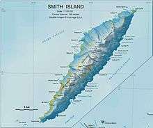
Topographic map of Smith Island.
Maglizh Rocks (Bulgarian: Мъглижки скали, ‘Maglizhki Skali’ m&-'glizh-ki ska-'li) are a group of rocks off the northwest coast of Smith Island, South Shetland Islands. The two adjacent principal rocks extending 460 m (503 yd) in east-west direction and 140 m (153 yd) wide are situated 300 m (328 yd) north of Lista Point, with the third major one, 300 by 100 m, situated 320 m (350 yd) northwest of them. Combined surface area 10.6 hectares (26 acres).[1] Bulgarian early mapping in 2009. Named after the town of Maglizh in southern Bulgaria.
See also
- Composite Antarctic Gazetteer
- List of Antarctic islands south of 60° S
- SCAR
- Territorial claims in Antarctica
References
- ↑ L.L. Ivanov. Antarctica: Livingston Island and Greenwich, Robert, Snow and Smith Islands. Scale 1:120000 topographic map. Troyan: Manfred Wörner Foundation, 2009. ISBN 978-954-92032-6-4
External links
This article includes information from the Antarctic Place-names Commission of Bulgaria which is used with permission.
This article is issued from Wikipedia - version of the 11/17/2016. The text is available under the Creative Commons Attribution/Share Alike but additional terms may apply for the media files.