Salisbury Bluff

Location of Hurd Peninsula in the South Shetland Islands.
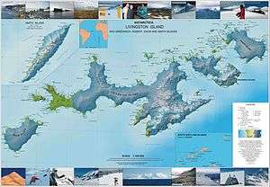
Topographic map of Livingston Island, Greenwich, Robert, Snow and Smith Islands.
Salisbury Bluff is the point forming the south side of the entrance to Las Palmas Cove in Hurd Peninsula, Livingston Island in the South Shetland Islands, Antarctica and surmounted by a 161 m height. The area was visited by early 19th century sealers operating from nearby Johnsons Dock.
The feature is named after the British sealing vessel Salisbury under Captain Thomas Hodges that visited the South Shetlands in 1820-21.
Location
The point is located at 62°41′10.9″S 60°25′35.6″W / 62.686361°S 60.426556°W which is 1.39 km south-southwest of Henry Bluff, 3.82 km north by east of Miers Bluff and 10.19 km east-southeast of Hannah Point (British mapping in 1968, detailed Spanish mapping in 1991, Bulgarian mapping in 2005 and 2009).
Maps
- Isla Livingston: Península Hurd. Mapa topográfico de escala 1:25 000. Madrid: Servicio Geográfico del Ejército, 1991.
- L.L. Ivanov et al., Antarctica: Livingston Island and Greenwich Island, South Shetland Islands (from English Strait to Morton Strait, with illustrations and ice-cover distribution), Scale 1: 100000 map, Antarctic Place-names Commission of Bulgaria, Ministry of Foreign Affairs, Sofia, 2005.
- L.L. Ivanov. Antarctica: Livingston Island and Greenwich, Robert, Snow and Smith Islands. Scale 1:120000 topographic map. Troyan: Manfred Wörner Foundation, 2009.
References
This article is issued from Wikipedia - version of the 11/21/2015. The text is available under the Creative Commons Attribution/Share Alike but additional terms may apply for the media files.