Bilyana Island
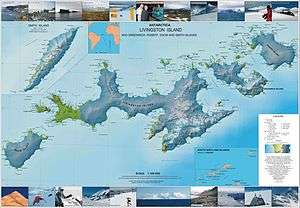 Topographic map of Livingston Island, Greenwich, Robert, Snow and Smith Islands. | |
 Location of Aitcho Islands in the South Shetland Islands. | |
| Geography | |
|---|---|
| Coordinates | 62°23′05″S 59°45′47″W / 62.38472°S 59.76306°WCoordinates: 62°23′05″S 59°45′47″W / 62.38472°S 59.76306°W |
| Archipelago | Aitcho group |
| Area | 10 ha (25 acres) |
| Length | 450 m (1,480 ft) |
| Width | 900 m (3,000 ft) |
| Administration | |
|
None | |
| Additional information | |
| Administered under the Antarctic Treaty System | |
Bilyana Island (Bulgarian: остров Биляна, ‘Ostrov Bilyana’ \'os-trov bi-'lya-na\) is an ice-free island in the Aitcho group on the west side of English Strait in the South Shetland Islands, Antarctica. Extending 450 by 290 m (490 by 320 yd), surface area 10 hectares (25 acres).[1] The area was visited by early 19th century sealers.
The island’s name derives from Bilyana, a name from Bulgarian music folklore.[2]
Location
The midpoint is located at 62°23′05″S 59°45′47″W / 62.38472°S 59.76306°W and the island is lying 100 m (110 yd) south of Jorge Island, 1.9 km (1.2 mi) north-northwest of Barrientos Island and 1.45 km (0.90 mi) northeast of Emeline Island (Bulgarian mapping in 2009).
See also
- Aitcho Islands
- Composite Antarctic Gazetteer
- List of Antarctic islands south of 60° S
- SCAR
- South Shetland Islands
- Territorial claims in Antarctica
References
- ↑ L.L. Ivanov. Antarctica: Livingston Island and Greenwich, Robert, Snow and Smith Islands. Scale 1:120000 topographic map. Troyan: Manfred Wörner Foundation, 2010. ISBN 978-954-92032-9-5 (First edition 2009. ISBN 978-954-92032-6-4)
- ↑ Bilyana Island. SCAR Composite Antarctic Gazetteer.
External links
- Bulgarian Antarctic Gazetteer. Antarctic Place-names Commission. (details in Bulgarian, basic data in English)
This article includes information from the Antarctic Place-names Commission of Bulgaria which is used with permission.