Saint-Aubin, Indre
| Saint-Aubin | |
|---|---|
|
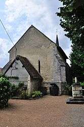
The church of Saint-Aubin, in Saint-Aubin | |
 Saint-Aubin | |
|
Location within Centre-Val de Loire region  Saint-Aubin | |
| Coordinates: 46°51′08″N 2°01′30″E / 46.8522°N 2.025°ECoordinates: 46°51′08″N 2°01′30″E / 46.8522°N 2.025°E | |
| Country | France |
| Region | Centre-Val de Loire |
| Department | Indre |
| Arrondissement | Issoudun |
| Canton | Issoudun-Sud |
| Intercommunality | Champagne berrichonne |
| Government | |
| • Mayor (2008–2014) | René Normant |
| Area1 | 28.32 km2 (10.93 sq mi) |
| Population (2009)2 | 187 |
| • Density | 6.6/km2 (17/sq mi) |
| Time zone | CET (UTC+1) |
| • Summer (DST) | CEST (UTC+2) |
| INSEE/Postal code | 36181 / 36100 |
| Elevation |
142–181 m (466–594 ft) (avg. 160 m or 520 ft) |
|
1 French Land Register data, which excludes lakes, ponds, glaciers > 1 km² (0.386 sq mi or 247 acres) and river estuaries. 2 Population without double counting: residents of multiple communes (e.g., students and military personnel) only counted once. | |
Saint-Aubin is a commune in the Indre department in central France.
Population
| Historical population | ||
|---|---|---|
| Year | Pop. | ±% |
| 1793 | 375 | — |
| 1800 | 333 | −11.2% |
| 1806 | 318 | −4.5% |
| 1821 | 348 | +9.4% |
| 1831 | 355 | +2.0% |
| 1836 | 381 | +7.3% |
| 1841 | 338 | −11.3% |
| 1846 | 381 | +12.7% |
| 1851 | 378 | −0.8% |
| 1856 | 406 | +7.4% |
| 1861 | 388 | −4.4% |
| 1866 | 377 | −2.8% |
| 1872 | 390 | +3.4% |
| 1876 | 412 | +5.6% |
| 1881 | 413 | +0.2% |
| 1886 | 391 | −5.3% |
| 1891 | 401 | +2.6% |
| 1896 | 386 | −3.7% |
| 1901 | 374 | −3.1% |
| 1906 | 400 | +7.0% |
| 1911 | 402 | +0.5% |
| 1921 | 334 | −16.9% |
| 1926 | 326 | −2.4% |
| 1931 | 336 | +3.1% |
| 1936 | 286 | −14.9% |
| 1946 | 311 | +8.7% |
| 1954 | 272 | −12.5% |
| 1962 | 217 | −20.2% |
| 1968 | 183 | −15.7% |
| 1975 | 142 | −22.4% |
| 1982 | 126 | −11.3% |
| 1990 | 155 | +23.0% |
| 1999 | 169 | +9.0% |
| 2006 | 162 | −4.1% |
| 2009 | 187 | +15.4% |
See also
References
| Wikimedia Commons has media related to Saint-Aubin (Indre). |
This article is issued from Wikipedia - version of the 2/12/2016. The text is available under the Creative Commons Attribution/Share Alike but additional terms may apply for the media files.
