Bélâbre
| Bélâbre | ||
|---|---|---|
|
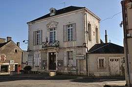
Town hall | ||
| ||
 Bélâbre | ||
|
Location within Centre-Val de Loire region  Bélâbre | ||
| Coordinates: 46°33′08″N 1°09′32″E / 46.5522°N 1.1589°ECoordinates: 46°33′08″N 1°09′32″E / 46.5522°N 1.1589°E | ||
| Country | France | |
| Region | Centre-Val de Loire | |
| Department | Indre | |
| Arrondissement | Le Blanc | |
| Canton | Bélâbre | |
| Intercommunality | Val d'Anglin | |
| Area1 | 40.14 km2 (15.50 sq mi) | |
| Population (2009)2 | 999 | |
| • Density | 25/km2 (64/sq mi) | |
| Time zone | CET (UTC+1) | |
| • Summer (DST) | CEST (UTC+2) | |
| INSEE/Postal code | 36016 / 36370 | |
| Elevation |
95–156 m (312–512 ft) (avg. 107 m or 351 ft) | |
|
1 French Land Register data, which excludes lakes, ponds, glaciers > 1 km² (0.386 sq mi or 247 acres) and river estuaries. 2 Population without double counting: residents of multiple communes (e.g., students and military personnel) only counted once. | ||
.svg.png)
Bélâbre is a commune in the Indre department in central France. It is the site of the Gallic city of Vosagum during the era of the Roman Empire's domination of this part of western [1]Gaul (France).
Geography
The commune is located in the parc naturel régional de la Brenne.
The river Anglin flows northwest through the commune and crosses the village.
Population
| Historical population | ||
|---|---|---|
| Year | Pop. | ±% |
| 1793 | 1,126 | — |
| 1800 | 898 | −20.2% |
| 1806 | 920 | +2.4% |
| 1821 | 1,031 | +12.1% |
| 1831 | 2,000 | +94.0% |
| 1836 | 2,136 | +6.8% |
| 1841 | 2,165 | +1.4% |
| 1846 | 2,234 | +3.2% |
| 1851 | 2,346 | +5.0% |
| 1856 | 2,217 | −5.5% |
| 1861 | 2,221 | +0.2% |
| 1866 | 2,210 | −0.5% |
| 1872 | 2,125 | −3.8% |
| 1876 | 2,105 | −0.9% |
| 1881 | 2,120 | +0.7% |
| 1886 | 2,085 | −1.7% |
| 1891 | 2,011 | −3.5% |
| 1896 | 1,918 | −4.6% |
| 1901 | 1,875 | −2.2% |
| 1906 | 1,874 | −0.1% |
| 1911 | 1,813 | −3.3% |
| 1921 | 1,556 | −14.2% |
| 1926 | 1,545 | −0.7% |
| 1931 | 1,507 | −2.5% |
| 1936 | 1,492 | −1.0% |
| 1946 | 1,515 | +1.5% |
| 1954 | 1,363 | −10.0% |
| 1962 | 1,277 | −6.3% |
| 1968 | 1,336 | +4.6% |
| 1975 | 1,260 | −5.7% |
| 1982 | 1,067 | −15.3% |
| 1990 | 1,062 | −0.5% |
| 1999 | 1,028 | −3.2% |
| 2009 | 999 | −2.8% |
See also
References
| Wikimedia Commons has media related to Bélâbre. |
This article is issued from Wikipedia - version of the 8/16/2016. The text is available under the Creative Commons Attribution/Share Alike but additional terms may apply for the media files.