Sainte-Fauste
| Sainte-Fauste | |
|---|---|
|
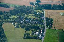
An aerial view of Sainte-Fauste | |
 Sainte-Fauste | |
|
Location within Centre-Val de Loire region  Sainte-Fauste | |
| Coordinates: 46°51′29″N 1°51′58″E / 46.8581°N 1.8661°ECoordinates: 46°51′29″N 1°51′58″E / 46.8581°N 1.8661°E | |
| Country | France |
| Region | Centre-Val de Loire |
| Department | Indre |
| Arrondissement | Issoudun |
| Canton | Issoudun-Sud |
| Intercommunality | Champagne berrichonne |
| Government | |
| • Mayor (2008–2014) | Jean Marc Brunaud |
| Area1 | 23.07 km2 (8.91 sq mi) |
| Population (2009)2 | 293 |
| • Density | 13/km2 (33/sq mi) |
| Time zone | CET (UTC+1) |
| • Summer (DST) | CEST (UTC+2) |
| INSEE/Postal code | 36190 / 36100 |
| Elevation |
142–168 m (466–551 ft) (avg. 141 m or 463 ft) |
|
1 French Land Register data, which excludes lakes, ponds, glaciers > 1 km² (0.386 sq mi or 247 acres) and river estuaries. 2 Population without double counting: residents of multiple communes (e.g., students and military personnel) only counted once. | |
Sainte-Fauste is a commune in the Indre department in central France.
Population
| Historical population | ||
|---|---|---|
| Year | Pop. | ±% |
| 1793 | 385 | — |
| 1800 | 396 | +2.9% |
| 1806 | 408 | +3.0% |
| 1821 | 483 | +18.4% |
| 1831 | 504 | +4.3% |
| 1836 | 473 | −6.2% |
| 1841 | 463 | −2.1% |
| 1846 | 449 | −3.0% |
| 1851 | 475 | +5.8% |
| 1856 | 482 | +1.5% |
| 1861 | 467 | −3.1% |
| 1866 | 460 | −1.5% |
| 1872 | 467 | +1.5% |
| 1876 | 442 | −5.4% |
| 1881 | 483 | +9.3% |
| 1886 | 484 | +0.2% |
| 1891 | 500 | +3.3% |
| 1896 | 445 | −11.0% |
| 1901 | 427 | −4.0% |
| 1906 | 448 | +4.9% |
| 1911 | 439 | −2.0% |
| 1921 | 461 | +5.0% |
| 1926 | 438 | −5.0% |
| 1931 | 371 | −15.3% |
| 1936 | 330 | −11.1% |
| 1946 | 325 | −1.5% |
| 1954 | 332 | +2.2% |
| 1962 | 299 | −9.9% |
| 1968 | 256 | −14.4% |
| 1975 | 218 | −14.8% |
| 1982 | 230 | +5.5% |
| 1990 | 229 | −0.4% |
| 1999 | 253 | +10.5% |
| 2006 | 258 | +2.0% |
| 2009 | 293 | +13.6% |
See also
References
| Wikimedia Commons has media related to Sainte-Fauste. |
This article is issued from Wikipedia - version of the 2/9/2015. The text is available under the Creative Commons Attribution/Share Alike but additional terms may apply for the media files.