Jeu-Maloches
| Jeu-Maloches | |
|---|---|
|
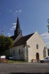
The church of Saint-Sulpice, in Jeu-Maloches | |
 Jeu-Maloches | |
|
Location within Centre-Val de Loire region  Jeu-Maloches | |
| Coordinates: 47°02′17″N 1°27′32″E / 47.0381°N 1.4589°ECoordinates: 47°02′17″N 1°27′32″E / 47.0381°N 1.4589°E | |
| Country | France |
| Region | Centre-Val de Loire |
| Department | Indre |
| Arrondissement | Châteauroux |
| Canton | Écueillé |
| Intercommunality | Pays d'Écueillé |
| Government | |
| • Mayor (2008–2014) | Claude Bonneau |
| Area1 | 12.73 km2 (4.92 sq mi) |
| Population (2009)2 | 129 |
| • Density | 10/km2 (26/sq mi) |
| Time zone | CET (UTC+1) |
| • Summer (DST) | CEST (UTC+2) |
| INSEE/Postal code | 36090 / 36240 |
| Elevation |
127–189 m (417–620 ft) (avg. 134 m or 440 ft) |
|
1 French Land Register data, which excludes lakes, ponds, glaciers > 1 km² (0.386 sq mi or 247 acres) and river estuaries. 2 Population without double counting: residents of multiple communes (e.g., students and military personnel) only counted once. | |
Jeu-Maloches is a commune in the Indre department in central France.
Population
| Historical population | ||
|---|---|---|
| Year | Pop. | ±% |
| 1793 | 343 | — |
| 1800 | 370 | +7.9% |
| 1806 | 318 | −14.1% |
| 1821 | 323 | +1.6% |
| 1831 | 334 | +3.4% |
| 1836 | 336 | +0.6% |
| 1841 | 320 | −4.8% |
| 1846 | 343 | +7.2% |
| 1851 | 335 | −2.3% |
| 1856 | 321 | −4.2% |
| 1861 | 308 | −4.0% |
| 1866 | 342 | +11.0% |
| 1872 | 363 | +6.1% |
| 1876 | 371 | +2.2% |
| 1881 | 356 | −4.0% |
| 1886 | 366 | +2.8% |
| 1891 | 401 | +9.6% |
| 1896 | 403 | +0.5% |
| 1901 | 383 | −5.0% |
| 1906 | 385 | +0.5% |
| 1911 | 378 | −1.8% |
| 1921 | 341 | −9.8% |
| 1926 | 311 | −8.8% |
| 1931 | 294 | −5.5% |
| 1936 | 312 | +6.1% |
| 1946 | 334 | +7.1% |
| 1954 | 320 | −4.2% |
| 1962 | 269 | −15.9% |
| 1968 | 230 | −14.5% |
| 1975 | 190 | −17.4% |
| 1982 | 175 | −7.9% |
| 1990 | 160 | −8.6% |
| 1999 | 121 | −24.4% |
| 2009 | 129 | +6.6% |
See also
References
| Wikimedia Commons has media related to Jeu-Maloches. |
This article is issued from Wikipedia - version of the 7/16/2016. The text is available under the Creative Commons Attribution/Share Alike but additional terms may apply for the media files.
