Røldalsvatnet
| Røldalsvatnet | |
|---|---|
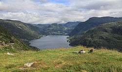 View of the lake | |
| Location | Odda, Hordaland |
| Coordinates | 59°48′27″N 6°46′53″E / 59.8075°N 6.7813°E / 59.8075; 6.7813Coordinates: 59°48′27″N 6°46′53″E / 59.8075°N 6.7813°E / 59.8075; 6.7813 |
| Basin countries | Norway |
| Max. length | 8.8 kilometres (5.5 mi) |
| Max. width | 1.3 kilometres (0.81 mi) |
| Surface area | 6.99 km2 (2.70 sq mi) |
| Shore length1 | 20.64 kilometres (12.83 mi) |
| Surface elevation | 380 metres (1,250 ft) |
| References | NVE |
| 1 Shore length is not a well-defined measure. | |
Røldalsvatnet is a lake in the municipality of Odda in Hordaland county, Norway. The 6.99-square-kilometre (2.70 sq mi) lake is located about 35 kilometres (22 mi) south of the town of Odda. The village of Røldal is located at the northern tip of the lake and the village of Botnen is located at the southern end. The European route E134 highway runs along the northern end of the lake, and the Norwegian National Road 13 runs along the western shore of the lake.[1]
See also
References
- ↑ Store norske leksikon. "Røldalsvatnet" (in Norwegian). Retrieved 2014-06-13.
This article is issued from Wikipedia - version of the 6/14/2014. The text is available under the Creative Commons Attribution/Share Alike but additional terms may apply for the media files.