Progreso Municipality, Yucatán
| Progreso | ||
|---|---|---|
| Municipality | ||
|
Municipal Palace of Progreso, Yucatán | ||
| ||
 Region 2 Noroeste #059 | ||
|
Progreso Location of the Municipality in Mexico | ||
| Coordinates: 21°16′58″N 89°39′49″W / 21.28278°N 89.66361°WCoordinates: 21°16′58″N 89°39′49″W / 21.28278°N 89.66361°W | ||
| Country |
| |
| State |
| |
| Government | ||
| • Type |
| |
| • Municipal President | Daniel Zacarias Martinez[2] | |
| Area | ||
| • Total | 270.10 km2 (104.29 sq mi) | |
| [2] | ||
| Elevation[2] | 2 m (7 ft) | |
| Population (2010[3]) | ||
| • Total | 53,958 | |
| Time zone | Central Standard Time (UTC-6) | |
| • Summer (DST) | Central Daylight Time (UTC-5) | |
| INEGI Code | 009 | |
| Major Airport | Merida (Manuel Crescencio Rejón) International Airport | |
| IATA Code | MID | |
| ICAO Code | MMMD | |
| Website | Official Website | |
.jpg)

Progreso Municipality (In the Spanish language: “progress”) is one of the 106 municipalities in the Mexican state of Yucatán containing (270.10 km2) of land and located roughly 25 km north of the city of Mérida.[2]
History
Progreso is one of the youngest towns in the Yucatán.[2] Juan Miguel Castro Martín, owner of several sisal haciendas, including an estate called Hacienda San Pedro Chimay was the founder of the Port of Progreso.[4] He began urging development of a new port in 1840 to further the henequen trade.[5] The town was authorized under President Ignacio Comonfort on 25 February 1856 and was officially founded on 1 July 1871 as the Port of Progreso.[2]
On 8 January 1875, the first City Council was formed and the town was elevated to a villa, soon after decreed a city by the state government, and construction of the city hall commenced. In 1881, freight and passenger rail service began and in 1893, the lighthouse opened.[2]
In 1936, the Danish company "Christiane & Nielsen" began construction of malecón (sea wall), which was completed in 1947. It was upgraded in 1968[2] In 2011, work began to rebuild the malecón and upgrade the entrance of the port.[6]
Governance
The municipal president is elected for a term of three years. The president appoints nine Councilpersons to serve on the board for three year terms, as the Secretary and councilors who oversee police and police stations; health and public works; transportation and education; special events; disability regulations; recruitment; and parks and public gardens.[7]
The Municipal Council administers the business of the municipality. It is responsible for budgeting and expenditures and producing all required reports for all branches of the municipal administration. Annually it determines educational standards for schools.[7]
The Police Commissioners ensure public order and safety. They are tasked with enforcing regulations, distributing materials and administering rulings of general compliance issued by the council.[7]
Communities
The head of the municipality is Progreso, Yucatán. The populated communities include Campestre Flamboyanes, Chelem, Chen Huayún, Chicxulub Puerto, Chuburná, El Divino Redentor, El Paraíso, Estopas Peninsulares, Ha Uay, Jesús Nazareno, La Gracia de Dios, La Perseverancia, Montesino, Progreso, Rancho San Pedro, San Antonio, San Ignacio, San Juan, and Yucmich.[8] The major population areas are shown below:[2]
| Community | Population |
|---|---|
| Entire Municipality (2010) | 53,958[3] |
| Campestre Flamboyanes | 3022 in 2005[9] |
| Chelem | 3017 in 2005[10] |
| Chicxulub Puerto | 5052 in 2005[11] |
| Chuburná | 1720 in 2005[12] |
| Progreso | 35519 in 2005[13] |
| San Ignacio | 767 in 2005[14] |
Local festivals
Every year a carnival is celebrated from 15 to 30 April and 1 June is a fiesta for the Navy. On 7 August, the feast of San Telmo, patron of fishermen, is recognized.[2]
Notable citizens
- Juan Miguel Castro Martín
Tourist attractions
- 19th Century Maritime Customs Building
- Municipal Palace
- Progreso lighthouse
- Customs Pier considered the longest in the country
- Chapel of San Antonio Yaxactún
- Hacienda Cuyo de Ancona
- Hacienda San Ignacio
References
- ↑ "Daniel Zacarías será el abanderado del PRI para la alcaldía de Progreso: Ernesto Martínez va por la diputación". Progreso Hoy (in Spanish). Progreso Hoy. December 10, 2011. Retrieved 5 June 2015.
- 1 2 3 4 5 6 7 8 9 10 "Municipios de Yucatán » Progreso" (in Spanish). Retrieved 5 June 2015.
- 1 2 "Mexico In Figures:Progreso, Yucatán". INEGI (in Spanish and English). Aguascalientes, México: Instituto Nacional de Estadística y Geografía (INEGI). Retrieved 5 June 2015.
- ↑ "Hacienda San Pedro Chimay". Haciendas en Yucatan (in Spanish). Mérida, Mexico: Gobierno del Estado de Yucatán. Retrieved 10 May 2015.
- ↑ "Ayuntamiento Constitucional de Progreso" (PDF). Diario Oficial del Gobierno del Estado (in Spanish). Progreso, Mexico: Ayuntamiento de Progreso: 1–3. 12 April 2006. Retrieved 5 June 2015.
- ↑ Escárcega, Mary (14 March 2011). "Yucatán construye Malecón en Puerto Progreso" (in Spanish). Mexico City, Mexico: El Universal. Retrieved 5 June 2015.
- 1 2 3 "Progreso". inafed (in Spanish). Mérida, Mexico: Enciclopedia de Los Municipios y Delegaciones de México. Retrieved 5 June 2015.
- ↑ "Municipio de Progreso". PueblosAmerica (in Spanish). PueblosAmerica. 2005. Retrieved 5 June 2015.
- ↑ "Flamboyanes". PueblosAmerica (in Spanish). PueblosAmerica. 2005. Retrieved 3 June 2015.
- ↑ "Chelem". PueblosAmerica (in Spanish). PueblosAmerica. 2005. Retrieved 3 June 2015.
- ↑ "Chicxulub". PueblosAmerica (in Spanish). PueblosAmerica. 2005. Retrieved 3 June 2015.
- ↑ "Chuburná". PueblosAmerica (in Spanish). PueblosAmerica. 2005. Retrieved 5 June 2015.
- ↑ "Progreso". PueblosAmerica (in Spanish). PueblosAmerica. 2005. Retrieved 5 June 2015.
- ↑ "San Ignacio". PueblosAmerica (in Spanish). PueblosAmerica. 2005. Retrieved 3 June 2015.
Mérida (capital) | |||||||||||||||||||||||||||
| Topics | 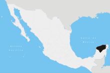 | ||||||||||||||||||||||||||
| Metros | |||||||||||||||||||||||||||
| Larger cities | |||||||||||||||||||||||||||
| Smaller cities |
| ||||||||||||||||||||||||||
| Municipalities |
| ||||||||||||||||||||||||||
