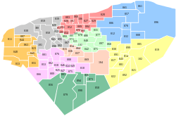
Kantunil Municipality
| Kantunil | |
|---|---|
| Municipality | |
 Region 3 Centro #042 | |
|
Kantunil Location of the Municipality in Mexico | |
| Coordinates: 20°47′45″N 89°02′05″W / 20.79583°N 89.03472°WCoordinates: 20°47′45″N 89°02′05″W / 20.79583°N 89.03472°W | |
| Country |
|
| State |
|
| Government | |
| • Type |
|
| • Municipal President | Felipe Pech Padilla[2] |
| Area | |
| • Total | 153.29 km2 (59.19 sq mi) |
| [2] | |
| Elevation[2] | 16 m (52 ft) |
| Population (2010[3]) | |
| • Total | 5,502 |
| Time zone | Central Standard Time (UTC-6) |
| • Summer (DST) | Central Daylight Time (UTC-5) |
| INEGI Code | 009 |
| Major Airport | Merida (Manuel Crescencio Rejón) International Airport |
| IATA Code | MID |
| ICAO Code | MMMD |
| Website | Official Website |
Kantunil Municipality (In the Yucatec Maya Language: “place of yellow or precious stone”) is one of the 106 municipalities in the Mexican state of Yucatán containing (153.29 km2) of land and located roughly 65 km southeast of the city of Mérida.[2]
History
There are no records indicating the history of pre-Hispanic times for this area. After the conquest the area became part of the encomienda system.[2] The known encomenderos for Kantunil are: Juan de Aguilar (1549)l Francisco López de Cieza (1552), Diego López de Cieza (1607), Pedro de Magaña Pacheco de la Cámara (1632), Pedro de Magaña y Contreras, José de Arrúe (1648), Alonso Chacón de Aguilar (1664-1688), Ignacio Chacón.[4]
Yucatán declared its independence from the Spanish Crown in 1821 and in 1825, the area was assigned to the Coast region with its headquarters in Izamal Municipality. In 1910, Kantunil and Holcá were the only settlements in the area.[2]
Governance
The municipal president is elected for a three year term. The town council has four aldermen, who serve as Secretary of the Town Hall; and councilors of heritage and patrimony; parks, public gardens and cemeteries; and public lighting.[5]
The Municipal Council administers the business of the municipality. It is responsible for budgeting and expenditures and producing all required reports for all branches of the municipal administration. Annually it determines educational standards for schools.[5]
The Police Commissioners ensure public order and safety. They are tasked with enforcing regulations, distributing materials and administering rulings of general compliance issued by the council.[5]
Communities
The head of the municipality is Kantunil, Yucatán. The other populated areas in the municipality are Guadalupe, Holcá, San Adrián, San Diego, San Dimas, San Felipe, San Pedro, Santa María, and Sualahtún. The significant populations are shown below:[2]
| Community | Population |
|---|---|
| Entire Municipality (2010) | 5,502[3] |
| Holcá | 1916 in 2005[6] |
| Kantunil | 3428 in 2005[7] |
Local festivals
Every year from 31 January to 4 February 4, is held a celebration in of the Virgin of Candelaria.[2]
Tourist attractions
- Church of the Virgin of Candelaria, built in the seventeenth century
- archaeological site at Coloba
- Cenote Chihuan
References
- ↑ "Listado oficial de los precandidatos del PRI a las 106 alcaldías de Yucatán" (in Spanish). Progreso, Mexico: Progreso Hoy. 18 December 2011. Retrieved 8 June 2015.
- 1 2 3 4 5 6 7 8 "Municipios de Yucatán » Kantunil" (in Spanish). Retrieved 9 June 2015.
- 1 2 "Mexico In Figures: Kantunil, Yucatán". INEGI (in Spanish and English). Aguascalientes, México: Instituto Nacional de Estadística y Geografía (INEGI). Retrieved 8 June 2015.
- ↑ García Bernal, Manuela Cristina (1978). Población y encomienda en Yucatán bajo los Austrias (in Spanish). Sevilla: Escuela de Estudios Hispano-Americanos. p. 492. ISBN 84-00-04399-5. Retrieved 9 June 2015.
- 1 2 3 "Kantunil". inafed (in Spanish). Mérida, Mexico: Enciclopedia de Los Municipios y Delegaciones de México. Retrieved 4 June 2015.
- ↑ "Holcá". PueblosAmerica (in Spanish). PueblosAmerica. 2005. Retrieved 8 June 2015.
- ↑ "Kantunil". PueblosAmerica (in Spanish). PueblosAmerica. 2005. Retrieved 8 June 2015.
Mérida (capital) | |||||||||||||||||||||||||||
| Topics | 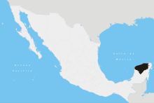 | ||||||||||||||||||||||||||
| Metros | |||||||||||||||||||||||||||
| Larger cities | |||||||||||||||||||||||||||
| Smaller cities |
| ||||||||||||||||||||||||||
| Municipalities |
| ||||||||||||||||||||||||||