Pine Township, Clearfield County, Pennsylvania
| Pine Township, Clearfield County, Pennsylvania | |
|---|---|
| Township | |
|
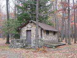
A CCC built latrine at S. B. Elliott State Park | |
|
Map of Clearfield County, Pennsylvania highlighting Pine Township | |
|
Map of Clearfield County, Pennsylvania | |
| Country | United States |
| State | Pennsylvania |
| County | Clearfield |
| Incorporated | 1873 |
| Area | |
| • Total | 32.0 sq mi (83.0 km2) |
| Population (2010) | |
| • Total | 60 |
| • Density | 2.4/sq mi (0.9/km2) |
| Time zone | Eastern (EST) (UTC-5) |
| • Summer (DST) | EDT (UTC-4) |
| Area code(s) | 814 |
| Historical population | |||
|---|---|---|---|
| Census | Pop. | %± | |
| 2000 | 77 | — | |
| 2010 | 60 | −22.1% | |
Pine Township is a township in Clearfield County, Pennsylvania, United States. The population was 60 at the 2010 census.[1] S. B. Elliott State Park a Pennsylvania state park is in Pine Township. Many of the structures at the park were built by the Civilian Conservation Corps during the Great Depression and are now on the National Register of Historic Places.
Geography
According to the United States Census Bureau, the township has a total area of 32.0 square miles (83.0 km²), all of it land.
Communities
- Anderson Creek
Demographics
As of the census[2] of 2000, there were 77 people, 34 households, and 24 families residing in the township. The population density was 2.4 people per square mile (0.9/km²). There were 117 housing units at an average density of 3.7/sq mi (1.4/km²). The racial makeup of the township was 100.00% White.
There were 34 households, out of which 26.5% had children under the age of 18 living with them, 67.6% were married couples living together, 2.9% had a female householder with no husband present, and 26.5% were non-families. 26.5% of all households were made up of individuals, and 11.8% had someone living alone who was 65 years of age or older. The average household size was 2.26 and the average family size was 2.52.
In the township the population was spread out, with 18.2% under the age of 18, 3.9% from 18 to 24, 36.4% from 25 to 44, 31.2% from 45 to 64, and 10.4% who were 65 years of age or older. The median age was 41 years. For every 100 females there were 102.6 males. For every 100 females age 18 and over, there were 90.9 males.
The median income for a household in the township was $53,750, and the median income for a family was $61,875. Males had a median income of $36,500 versus $33,750 for females. The per capita income for the township was $26,319. There were no families and 6.8% of the population living below the poverty line, including no under eighteens and 27.3% of those over 64.
School district
References
- ↑ http://www.census.gov/2010census/
- ↑ "American FactFinder". United States Census Bureau. Retrieved 2008-01-31.
Municipalities and communities of Clearfield County, Pennsylvania, United States | ||
|---|---|---|
| City | ||
| Boroughs | ||
| Townships | ||
| CDPs | ||
| Unincorporated communities | ||
| Footnotes | ‡This populated place also has portions in an adjacent county or counties | |
Coordinates: 41°07′36″N 78°29′55″W / 41.12667°N 78.49861°W