Meurthe-et-Moselle
| Meurthe-et-Moselle | ||
|---|---|---|
| Department | ||
|
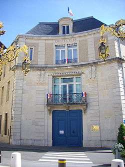
Prefecture building of the Meurthe-et-Moselle department, in Nancy | ||
| ||
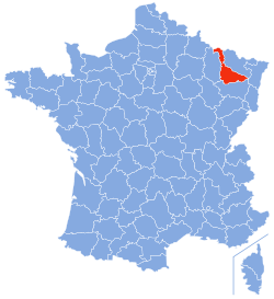 Location of Meurthe-et-Moselle in France | ||
| Coordinates: 48°40′N 06°10′E / 48.667°N 6.167°ECoordinates: 48°40′N 06°10′E / 48.667°N 6.167°E | ||
| Country | France | |
| Region | Grand Est | |
| Prefecture | Nancy | |
| Subprefectures |
Briey Lunéville Toul | |
| Government | ||
| • President of the General Council | Mathieu Klein | |
| Area1 | ||
| • Total | 5,246 km2 (2,025 sq mi) | |
| Population (2013) | ||
| • Total | 731,004 | |
| • Rank | 33rd | |
| • Density | 140/km2 (360/sq mi) | |
| Time zone | CET (UTC+1) | |
| • Summer (DST) | CEST (UTC+2) | |
| Department number | 54 | |
| Arrondissements | 4 | |
| Cantons | 23 | |
| Communes | 594 | |
| ^1 French Land Register data, which exclude estuaries, and lakes, ponds, and glaciers larger than 1 km2 | ||

| Part of the series on |
| Lorraine |
|---|
 Flag of Lorraine since the 13th century |
|
|
Administrative divisions
|
|
Lorraine in the EU |
|
Related topics |
|
Meurthe-et-Moselle (French pronunciation: [mœʁte mɔzɛl]) is a department in the Grand Est region of France, named after the Meurthe and Moselle rivers.
History
Meurthe-et-Moselle was created in 1871 at the end of the Franco-Prussian War from the parts of the former departments of Moselle and Meurthe which remained French territory.
The current boundary between Meurthe-et-Moselle and Moselle was the border between France and Germany from 1871 to 1919 and again between 1940 and 1944. The only subsequent change took place in 1997 and involved the incorporation, for administrative reasons, of the little commune of Han-devant-Pierrepont which had previously fallen within the Meuse department.
Geography
Meurthe-et-Moselle is part of the administrative region of Grand Est and the traditional region of Lorraine and is surrounded by the departments of Meuse, Vosges, Bas-Rhin, and Moselle; and by the nations of Luxembourg and Belgium. Parts of Meurthe-et-Moselle belong to the Lorraine Regional Natural Park.
The department extends for 130 km from north to south and is between 7 and 103 km wide.
Its chief rivers are:
| Rank | Commune | Canton | Arrondissement | Population |
|---|---|---|---|---|
| 1 | Nancy | Nancy-1 Nancy-2 Nancy-3 |
Nancy | 104,072 |
| 2 | Vandœuvre-lès-Nancy | Vandœuvre-lès-Nancy | Nancy | 29,836 |
| 3 | Lunéville | Lunéville-1 Lunéville-2 |
Lunéville | 19,516 |
| 4 | Toul | Toul | Toul | 16,128 |
| 5 | Pont-à-Mousson | Pont-à-Mousson | Nancy | 14,792 |
| 6 | Laxou | Laxou | Nancy | 14,681 |
| 7 | Villers-lès-Nancy | Laxou | Nancy | 14,133 |
| 8 | Longwy | Longwy | Briey | 14,092 |
| 9 | Dombasle-sur-Meurthe | Lunéville-1 | Nancy | 9,953 |
| 10 | Maxéville | Val de Lorraine Sud | Nancy | 9,796 |
Economy
The economy was highly dependent on mining until the 1960s. There are iron, salt, and lime extraction sites. The urban area around Nancy has a very dynamic economy based largely on services, research, and higher education.
Demographics
The inhabitants of the department are known as Meurthe-et-Mosellans. The area around Nancy has become highly urbanized, whereas the Saintois in the south is quite rural.
Tourism

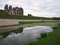 Walls and cathedral of Toul
 House near the château of Prény
 General Lasalle monument in Lunéville
 The Moselle river near Pont-à-Mousson
See also
- Arrondissements of the Meurthe-et-Moselle department
- Cantons of the Meurthe-et-Moselle department
- Communes of the Meurthe-et-Moselle department
References
- ↑ "Insee - Populations légales 2013". Insee. Retrieved September 11, 2016.
External links
| Wikimedia Commons has media related to Meurthe-et-Moselle. |
- Prefecture website (French)
- General council website (French)
- Tourism website (French)
| Members |  | |||||||||||||||
|---|---|---|---|---|---|---|---|---|---|---|---|---|---|---|---|---|
| Institutions | ||||||||||||||||
