Haute-Vienne
| Haute-Vienne | ||
|---|---|---|
| Department | ||
|
Prefecture building of the Haute-Vienne department, in Limoges | ||
| ||
 Location of Haute-Vienne in France | ||
| Coordinates: 45°50′N 1°16′E / 45.833°N 1.267°ECoordinates: 45°50′N 1°16′E / 45.833°N 1.267°E | ||
| Country | France | |
| Region | Nouvelle-Aquitaine | |
| Prefecture | Limoges | |
| Subprefectures |
Bellac Rochechouart | |
| Government | ||
| • President of the General Council | Marie-Françoise Pérol-Dumont (PS) | |
| Area1 | ||
| • Total | 5,520 km2 (2,130 sq mi) | |
| Population (2013) | ||
| • Total | 375,856 | |
| • Rank | 63rd | |
| • Density | 68/km2 (180/sq mi) | |
| Time zone | CET (UTC+1) | |
| • Summer (DST) | CEST (UTC+2) | |
| Department number | 87 | |
| Arrondissements | 3 | |
| Cantons | 21 | |
| Communes | 200 | |
| ^1 French Land Register data, which exclude estuaries, and lakes, ponds, and glaciers larger than 1 km2 | ||


Haute-Vienne (French pronunciation: [ot vjɛn]) is a French department named after the river Vienne. It is one of the 12 departments that together constitute the French region of Nouvelle-Aquitaine. The neighbouring departments are: Creuse, Corrèze, Dordogne, Charente, Vienne and Indre.
There are three arrondissements (administrative regions) in the department; the Arrondissement of Limoges, the capital of which is Limoges; the Arrondissement of Bellac, the capital of which is Bellac, some 45 km (28 mi) to the northwest of Limoges; and the Arrondissement of Rochechouart, with its capital, Rochechouart to the west of Limoges. The chief and largest city in the department is Limoges, the other towns in the department each having fewer than twenty thousand inhabitants.
Geography
Haute-Vienne is part of the Nouvelle-Aquitaine region. It is bordered by six departments; Creuse lies to the east, Corrèze to the south, Dordogne to the southwest, Charente to the west, Vienne to the northwest and Indre to the north. The department has two main rivers which cross it from east to west; the Vienne, on which the two main cities, Limoges and Saint-Junien, are situated, and the Gartempe, a tributary of the Creuse. To the southeast of the department lies the Massif Central, and the highest point in the department is Puy Lagarde, 795 m (2,608 ft). The source of the Charente is in the department, in the commune of Chéronnac, near Rochechouart.[1]
At the west end of the department is the Rochechouart crater, an impact crater caused by a meteorite that crashed into the earth's surface over 200 million years ago; because of subsequent erosion, little sign of the crater is in evidence today apart from the geologic effects on the surrounding rock.[2]
History
A few Paleolithic and Mesolithic remains have been found in the department, Neolithic inhabitants are attested to by standing stones and by burial chambers, like the dolmen Chez Boucher in La Croix-sur-Gartempe, and others at Berneuil and Breuilaufa.[3] Artefacts from the Bronze Age include axe heads found at Châlus. With the coming of the Romans, trade was opened up and gold and tin were mined. Agriculture developed and grapes were grown; amphorae for storing wine were found at Saint-Gence. During the reign of Augustus, the city of Augustoritum was founded (later to become Limoges) at a strategic ford across the Vienne. The Romans built roads from here to Brittany, Lyon and the Mediterranean. The city declined in the 3rd Century when barbarian invasions of the region took place.
The domination of the Visigoths was short-lived and Clovis I seized control of Limousin after the battle of Vouillé in 507.[4] By 674, the region was attached to the duchy of Aquitaine, and the Viscount of Limoges was created. There followed an unsettled period with various powers vying for control. In 1199, Richard Cœur de Lion was mortally wounded during the siege of the Château de Châlus-Chabrol. The region was much involved in the Hundred Years' War and at the Treaty of Brétigny in 1360, France granted England a large area of territory comprising much of Limousin. Limoges city rebelled and gave its allegiance to the French crown, and as a result was sacked in 1370. Further troubled years followed but when peace was restored, the department benefited economically; tanneries sprang up by the Vienne, paper was produced, printing developed and the area became known for fine enamelwork. After a revolt by the peasants, Henri IV brought peace and prosperity to the region of Limousin. He visited Limoges in 1607 and was greeted enthusiastically. The Counter-Reformation led to the creation of numerous convents and religious orders, especially in Limoges. In 1761, Anne Robert Jacques Turgot was appointed intendent (tax collector) of Limoges. He negotiated a reduction in taxes payable by the region and developed fairer methods of collecting taxes, as well as improving the road system and encouraging agricultural development.[5] Around 1765, kaolin was discovered near Saint-Yrieix-la-Perche in the south of the department, and the porcelain industry developed.
The department was created on 4 March 1790, during the French Revolution, the southern half being a subdivision of the Region of Limousin while the northern half was carved out of the county of Marche, as well as some parts of Angoumois and Poitou. At first it was given the number 81, but in the nineteenth century, the number was changed to the 87th department, when further land to the east and northeast was added. It takes its name from the upper reaches of the Vienne which flows through it. In 1998, the southwest part of the department, together with the northern part of the region of Périgord was designated as the Parc Naturel Régional Périgord-Limousin.[6]
Economy
In 2013, twenty million euros were earned from agriculture in the province, as against twenty-one million three hundred thousand from Limousin. There were 351,475 cattle in Haute-Vienne, 22,780 pigs, 320,500 sheep and 6,500 goats. 723,340 hectolitres of milk were produced from cows and 30,690 hectolitres from sheep. In the same year, 1,897,800 hectares of cereals were grown and in the previous year, 12,294 hectares of land were producing organic foodstuffs.[7]
Demographics
In 1801, the population of the department was 245,150. It grew steadily over the next century so that in 1901 it was 381,753. It peaked at 385,732 in 1906, fell back slightly in 1911 to 384,736 and fell sharply to 350,235 in 1921, after the Great War. By 1954 it had dwindled to 324,429 but after that it began to rise again, and in 2007 stood at 371,102.[8]
The three arrondissements of the Haute-Vienne department are:
- Arrondissement of Bellac, (subprefecture: Bellac) with 63 communes. The population of the arrondissement was 42,687 in 1990 and 40,120 in 1999, a decrease of 6.01%.
- Arrondissement of Limoges, (prefecture of the Haute-Vienne department: Limoges) with 108 communes. The population of the arrondissement was 274,643 in 1990 and 278,439 in 1999, an increase of 1.38%.
- Arrondissement of Rochechouart, (subprefecture: Rochechouart) with 30 communes. The population of the arrondissement was 36,263 in 1990 and 35,334 in 1999, a decrease of 2.56%.
Tourism
.jpg)
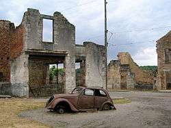 Ruins of Oradour-sur-Glane


%2C_paysage_matinal.JPG)
Notable people
- Richard the Lion Heart (September 8, 1157, Beaumont Palace in Oxford - April 6, 1199, the castle of Chalus Chabrol) was King of England, Duke of Normandy, Duke of Aquitaine, count of Poitiers, Count of Maine and Count of Anjou 1189 until his death in 1199. Son of Henry II of England and Eleanor of Aquitaine
- Jean-Baptiste Jourdan (1762-1833), Marshal of France
- Pierre Victurnien Vergniaud (1753-1793), revolutionary.
- Joseph Louis Gay-Lussac (1778-1850), chemist and physicist
- Maryse Bastié (1898-1952) aviator
- Jean Giraudoux (1882-1944) novelist and diplomat.
- Paul Rebeyrolle (1926-2005), artist
- Auguste Renoir (1841-1919), impressionist painter
- Sadi Carnot (1837-1894), French president
- Jean-Joseph Sanfourche (1929-2010), painter
- Nathanaël de Rincquesen born Nathanael Willecot Rincquesen of March 9, 1972 in Paris, is a French journalist and television presenter.
- Pierre Desproges, born May 9, 1939 in Pantin and died April 18, 1988 in Paris, is a French comedian known for his dark humor, his nonconformity and sense of the absurd.
- Suzanne Valadon (1865-1938), painter and artist's model
- Xavier Darcos (1947), politician
- Jean-Paul Denanot, is a French politician, member of the Socialist Party (PS).
- Pascal Sevran (1945-2008), songwriter, television host, who died in Limoges.
- Theo Sarapo is a singer and actor of Greek origin, born Theophanis Lamboukas January 26, 1936 in Paris and died August 28, 1970 in Limoges.
- Georges-Emmanuel Clancier, born May 3, 1914 in Limoges, was a French writer and poet.
- Roland Dumas (1922), politician.
- Robert Hébras (born June 29, 1925 in Oradour-sur-Glane) is one of six people who survived the massacre at Oradour-sur-Glane June 10, 1944 which became the France post -war a national symbol of Nazi atrocities.
- Raymond Poulidor, said "Poupou" is a French cyclist, born April 15, 1936 in Masbaraud-Mérignat in the department of Creuse. Its popularity ( "poupoularité") was exceptional in France, despite its status of "eternal second" in the Tour de France, a race he never won and in which he never carried the yellow jersey, but he holds the record of podium finishes (eight).
- Martial Valin (1898-1980), commander of the Free French Air Force.
- François Mitterrand is linked in Limoges because his grandfather Joseph was born September 27, 1873 in Limoges, died in 1946 in Jarnac
- Edmond Gondinet (1828-1888) is a French playwright.
- Laetitia Milot, an actress, model and French writer born on July the 5th, 1980. She is known for her role as Melanie Rinato in the popular soap opera Plus belle la vie and participated in the fourth season of Dancing with the Stars in which she finished third.
See also
- Cantons of the Haute-Vienne department
- Communes of the Haute-Vienne department
- Arrondissements of the Haute-Vienne department
References
- ↑ Philips' Modern School Atlas. George Philip and Son, Ltd. 1973. p. 43. ISBN 0-540-05278-7.
- ↑ "Rochechouart". Earth impact database. Planetary and Space Science Centre, University of New Brunswick, Canada. Retrieved 2015-09-14.
- ↑ "Circuit des Mégalithes (CIEUX - Monts de Blond)" (in French). Tourisme Intercommunal du Haut Limousin. Retrieved 2015-09-12.
- ↑ J.A.A. Barny de Romanet; Rougnard; Bibliothèque du Palais des Arts (1821). Histoire de Limoges et du Haut et Bas Limousin, mise en harmonie avec les points les plus curieux de l'histoire de France... H. et P. Barbou Frères. pp. 347–.
- ↑ Anne Robert Jacques Turgot, 1727-1781: Volume 27 of Short list, Bernard Quaritch (Firma). Bernard Quaritch. 2000.
- ↑ Abram, David (2003). The Rough Guide to France. Rough Guides. p. 683. ISBN 978-1-84353-056-5.
- ↑ "Limousin region: Agricultural statistics" (in French). Institut National de la statistique. Retrieved 2015-09-12.
- ↑ "Évolution de la population". Historique de la Haute-Vienne. Retrieved 2015-09-12.
External links
- (French) Prefecture website
- (French) General Council website
- (French) tourism